Master 1 Q2: Spoorzone Haarlem
17
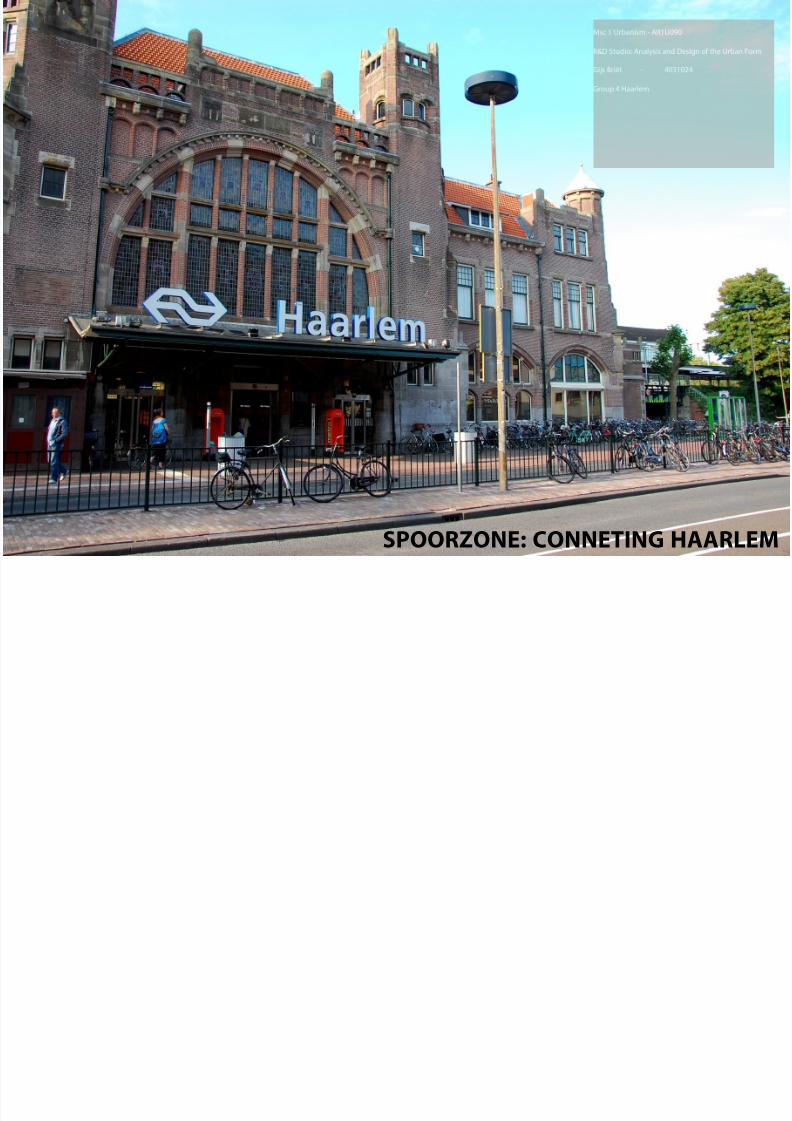
1 SPOORZONE: CONNETING HAARLEM
-
Upload
gijs-briet -
Category
Documents
-
view
222 -
download
0
Transcript of Master 1 Q2: Spoorzone Haarlem
8/6/2019 Master 1 Q2: Spoorzone Haarlem
http://slidepdf.com/reader/full/master-1-q2-spoorzone-haarlem 1/17
1
SPOORZONE: CONNETING HAARLEM
8/6/2019 Master 1 Q2: Spoorzone Haarlem
http://slidepdf.com/reader/full/master-1-q2-spoorzone-haarlem 2/17
CONCLUSION
gijs jasper
INDIVIDUAL
yawen domantas
GENERAL2
Msc 1 Urbanism
AR1U090 R&D Studio: Analysis and Design of the Urban Form
Delft, 1 november 2010
Group 4
City: Haarlem
Gijs Briët # 4031024 [email protected]
Mentor: Dr. ir. F.D. van der Hoeven
keywords:Haarlem, connections, green structure, infrastructure, train terminal, orientation
8/6/2019 Master 1 Q2: Spoorzone Haarlem
http://slidepdf.com/reader/full/master-1-q2-spoorzone-haarlem 3/17
MSc 1 • Q1 • AR1U090 R&D Studio • HAARLEM • Dr. ir. F.D. van der Hoeve
J a s p e r B r a s - 1 4 0 2 5 7 9 • Y a w e n D e n g - 4 1 2 3 3 3 6 • D o m a n t a s S t u k a s - 4 1 1 6 2 6 7 • G i j s B r i e t - 4 0 3 1 0 2 4
3
I N D E X
INTRODUCTION
ANALYSIS
Current Infrastructure
Current Green Structure
Current Pedestrian Routes
Current Functions
Current Disorientation
Current Public TransportSummary Analysis
DESIGN PRINCIPLES
Future Infrastructure
Future Green Structure
Future Pedestrian Routes
Future Functions
Future Disorientation
Future Public Transport
Summary Design Principles
IMPLIMENTATION
MASTERPLAN
IMPRESSIONS
EVALUATION
p. 4
p. 5
p. 5
p. 6
p. 6
p. 7
p. 7p. 8
p. 9
p. 9
p. 10
p. 10
p. 11
p. 11
p. 12
p. 13
p. 14
p. 15
p. 16
8/6/2019 Master 1 Q2: Spoorzone Haarlem
http://slidepdf.com/reader/full/master-1-q2-spoorzone-haarlem 4/17
I N T R O D U C T I O N
CONCLUSION
gijs jasper
INDIVIDUAL
yawen domantas
GENERAL4
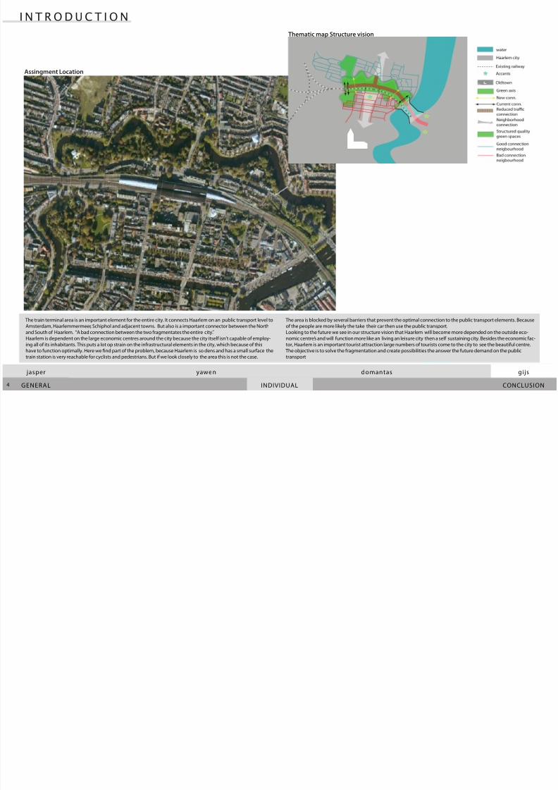
The area is blocked by several barriers that prevent the optimal connection to the public transport elements. Because
of the people are more likely the take their car then use the public transport.
Looking to the future we see in our structure vision that Haarlem will become more depended on the outside eco-
nomic centre’s and will function more like an living an leisure city then a self sustaining city. Besides the economic fac-
tor, Haarlem is an important tourist attraction large numbers of tourists come to the city to see the beautiful centre.
The objective is to solve the fragmentation and create possibilities the answer the future demand on the public
transport
The train terminal area is an important element for the entire city. It connects Haarlem on an public transport level to
Amsterdam, Haarlemmermeer, Schiphol and adjacent towns. But also is a important connector between the North
and South of Haarlem. “A bad connection between the two fragmentates the entire city.”
Haarlem is dependent on the large economic centres around the city because the city itself isn’t capable of employ-
ing all of its inhabitants. This puts a lot op strain on the infrastructural elements in the city, which because of this
have to function optimally. Here we nd part of the problem, because Haarlem is so dens and has a small surface the
train station is very reachable for cyclists and pedestrians. But if we look closely to the area this is not the case.
Assingment Location
Thematic map Structure vision
8/6/2019 Master 1 Q2: Spoorzone Haarlem
http://slidepdf.com/reader/full/master-1-q2-spoorzone-haarlem 5/17
MSc 1 • Q1 • AR1U090 R&D Studio • HAARLEM • Dr. ir. F.D. van der Hoeve
J a s p e r B r a s - 1 4 0 2 5 7 9 • Y a w e n D e n g - 4 1 2 3 3 3 6 • D o m a n t a s S t u k a s - 4 1 1 6 2 6 7 • G i j s B r i e t - 4 0 3 1 0 2 4
5
The green structures are separated by the road and the two housing blocks. The little green near the centre should
by dominant in the area currently it is overshadowed by the large infrastructure.
The fragmentation of the green on the North and South side causes the green structures to be unused. Decreasing
the amount of fast trac and increasing the connections for pedestrians and cyclists could attract more people to
the green structures and therefore become more used which would increase the potential and attraction of the area.
The road through the Bolwerken area is an important connection for the west side of Haarlem and beyond. It forms
a direct connection, which makes it alluring to use instead of giong around to city. This road is the main barrier in
the area, it makes the area unattracktive for slow trac and the train terminal hard to reach. Because the road is the
primary axis to the West a lot of trac has to go over it, which causes a lot of congestion. The road decreases to con-
nectivity of the important area, where there is supposed to be an even ow of slow trac from North to South it is
cut o/slowed down by this large barrier.
A N A L Y S E S
Current Infrastructure Current Green Structure
- The primary road the Zandvoort is a large barrier
- Barrier causes separation and fragmentation
- Car trac dominates the area
- Large number of connections/crossing to the primary road causes lots of congestion
- Very low percentage of green near city centre
- Green structure separated by road and railway
- Functions in the greenstructure create confusion of park is private of public.
8/6/2019 Master 1 Q2: Spoorzone Haarlem
http://slidepdf.com/reader/full/master-1-q2-spoorzone-haarlem 6/17
CONCLUSION
gijs jasper
INDIVIDUAL
yawen domantas
GENERAL6
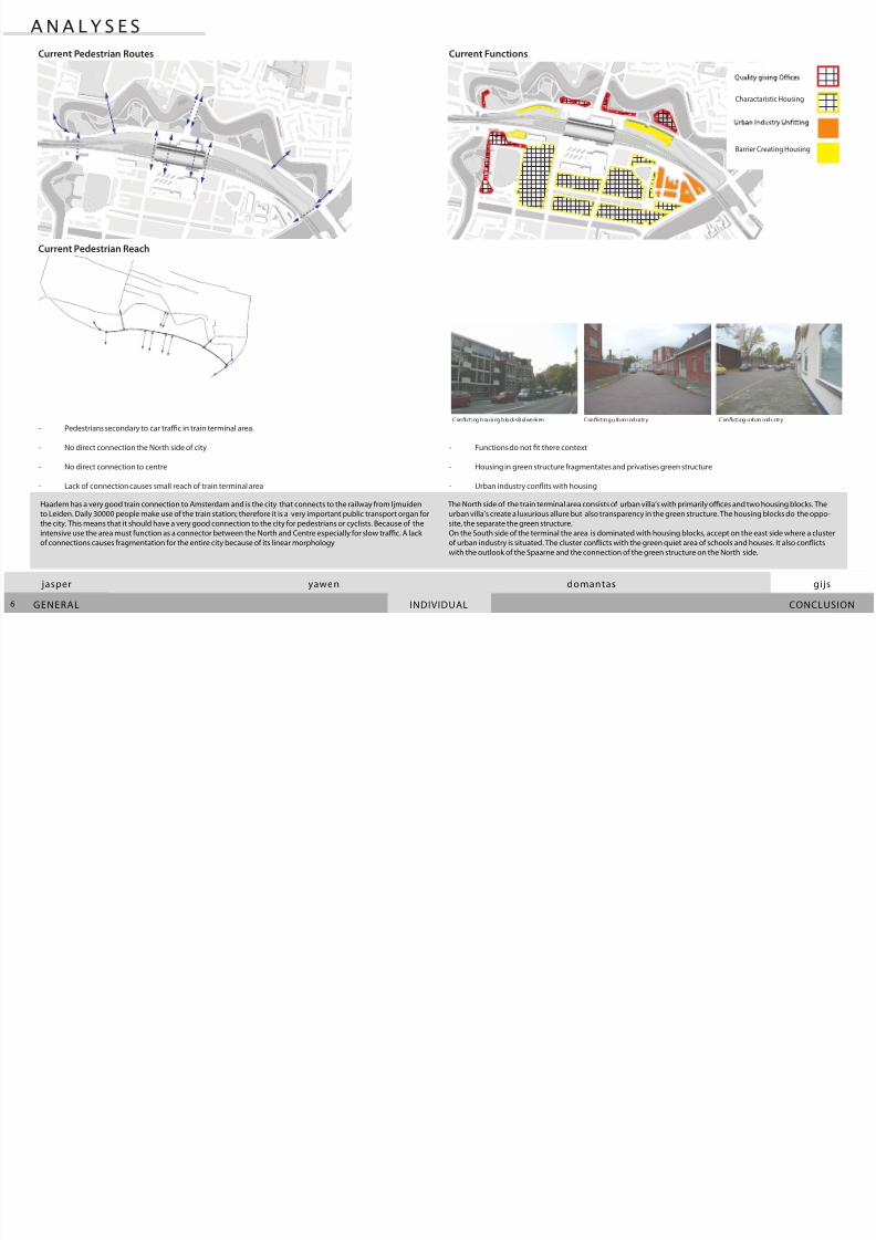
The North side of the train terminal area consists of urban villa’s with primarily oces and two housing blocks. The
urban villa’s create a luxurious allure but also transparency in the green structure. The housing blocks do the oppo-
site, the separate the green structure.
On the South side of the terminal the area is dominated with housing blocks, accept on the east side where a cluster
of urban industry is situated. The cluster conicts with the green quiet area of schools and houses. It also conicts
with the outlook of the Spaarne and the connection of the green structure on the North side.
Haarlem has a very good train connection to Amsterdam and is the city that connects to the railway from Ijmuiden
to Leiden. Daily 30000 people make use of the train station; therefore it is a very important public transport organ for
the city. This means that it should have a very good connection to the city for pedestrians or cyclists. Because of the
intensive use the area must function as a connector between the North and Centre especially for slow trac. A lack
of connections causes fragmentation for the entire city because of its linear morphology
A N A L Y S E S
Charactaristic Housing
Barrier Creating Housing
Current Pedestrian Routes Current Functions
Current Pedestrian Reach
- Pedestrians secondary to car trac in train terminal area.
- No direct connection the North side of city
- No direct connection to centre
- Lack of connection causes small reach of train terminal area
- Functions do not t there context
- Housing in green structure fragmentates and privatises green structure
- Urban industry conits with housing
Conict ing housing b locks B olwerken Conict ing urb an industry Conict ing urb an industry
8/6/2019 Master 1 Q2: Spoorzone Haarlem
http://slidepdf.com/reader/full/master-1-q2-spoorzone-haarlem 7/17
MSc 1 • Q1 • AR1U090 R&D Studio • HAARLEM • Dr. ir. F.D. van der Hoeve
J a s p e r B r a s - 1 4 0 2 5 7 9 • Y a w e n D e n g - 4 1 2 3 3 3 6 • D o m a n t a s S t u k a s - 4 1 1 6 2 6 7 • G i j s B r i e t - 4 0 3 1 0 2 4
7
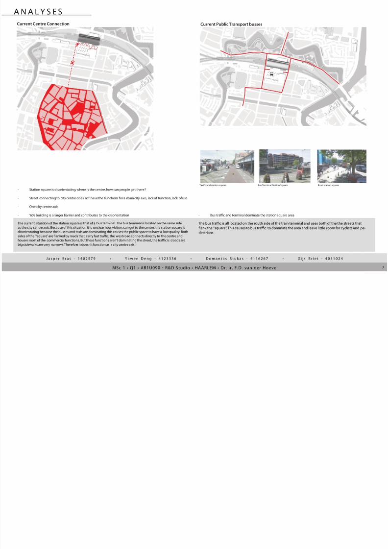
The bus trac is all located on the south side of the train terminal and uses both of the the streets that
ank the “square”. This causes to bus trac to dominate the area and leave little room for cyclists and pe-
destrians.
The current situation of the station square is that of a bus terminal. The bus terminal is located on the same side
as the city centre axis. Because of this situation it is unclear how visitors can get to the centre, the station square is
disorientating, because the busses and taxis are dominating this causes the public space to have a low quality. Both
sides of the ‘“square” are anked by roads that carry fast trac, the west road connects directly to the centre and
houses most of the commercial functions. But these functions aren’t dominating the street, the trac is (roads are
big sidewalks are very narrow). Therefore it doesn’t function as a city centre axis.
A N A L Y S E S
Current Centre Connection Current Public Transport busses
- Station square is disorientating, where is the centre, how can people get there?
- Street connecting to city centre does not have the functions for a main city axis, lack of function, lack of use
- One city centre axis
- ‘60s building is a larger barrier and contributes to the disorientation - Bus trac and terminal dominate the station square area
Taxi Stand station square Bus Terminal Station Square Road station square
8/6/2019 Master 1 Q2: Spoorzone Haarlem
http://slidepdf.com/reader/full/master-1-q2-spoorzone-haarlem 8/17CONCLUSION
gijs jasper
INDIVIDUAL
yawen domantas
GENERAL8
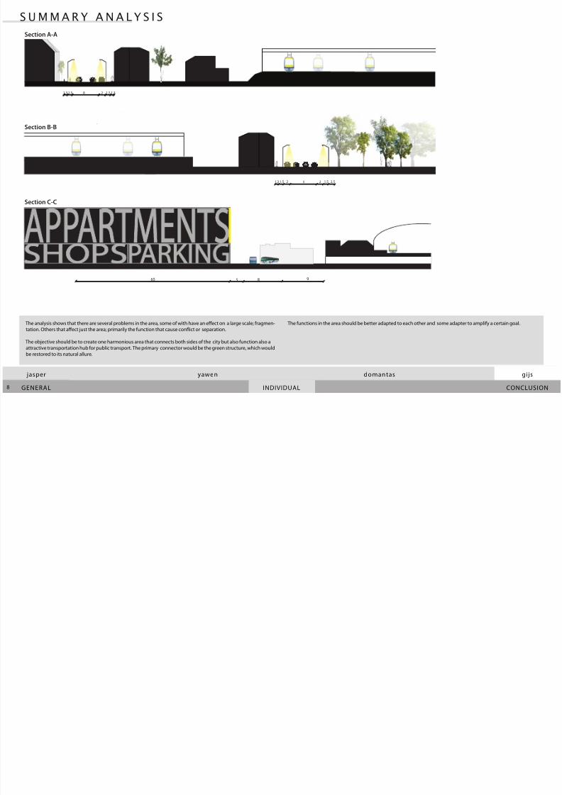
The functions in the area should be better adapted to each other and some adapter to amplify a certain goal. The analysis shows that there are several problems in the area, some of with have an eect on a large scale; fragmen-
tation. Others that aect just the area; primarily the function that cause conict or separation.
The objective should be to create one harmonious area that connects both sides of the city but also function also a
attractive transportation hub for public transport. The primary connector would be the green structure, which would
be restored to its natural allure.
S U M M A R Y A N A L Y S I S
3 .
28 1,51,3 1,5 1,3
28 1,51,3 1,5 2,52
9865 5
Section A-A
Section B-B
Section C-C
8/6/2019 Master 1 Q2: Spoorzone Haarlem
http://slidepdf.com/reader/full/master-1-q2-spoorzone-haarlem 9/17MSc 1 • Q1 • AR1U090 R&D Studio • HAARLEM • Dr. ir. F.D. van der Hoeve
J a s p e r B r a s - 1 4 0 2 5 7 9 • Y a w e n D e n g - 4 1 2 3 3 3 6 • D o m a n t a s S t u k a s - 4 1 1 6 2 6 7 • G i j s B r i e t - 4 0 3 1 0 2 4
khjgkydfhhhhhhhhhhhhhhhhhhhhhhhhhhhhhhhhhhhhhhhhhhhhhhhhhhhhhhhhhhhhhhhhhhhhhhh-
hhhhhhhhhhhhhhhhhhhhhhhhhhhhhhhhhhhhhhhhhhh
khjgkydfhhhhhhhhhhhhhhhhhhhhhhhhhhhhhhhhhhhhhhhhhhhhhhhhhhhhhhhhhhhhhhhhhhhhhhh-
hhhhhhhhhhhhhhhhhhhhhhhhhhhhhhhhhhhhhhhhhhh
9
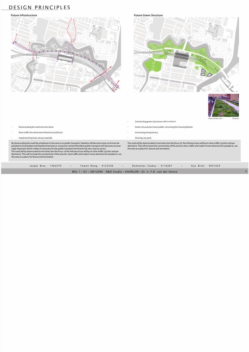
The road will by downscaled to two lanes but the focus of the infrastructure will by on slow trac (cyclists and pe-
destrians). This will increase the connectivity of the area for slow trac and make it more attractive for people to use
the area as a place for leisure and recreation.
By downscaling the road the emphases in the area is on public transport. Haarlem will become more a nd more de-
pended on Amsterdam and Haarlemmermeer as economic centre’s therefore public transport will becomes increas-
ingly important which makes it necessary for the public transport terminal to be very easy to access.
The road will by downscaled to two lanes but the focus of the infrastructure will by on slow trac (cyclists and pe-
destrians). This will increase the connectivity of the area for slow trac and make it more attractive for people to use
the area as a place for leisure and recreation.
D E S I G N P R I N C I P L E S
Future Infrastructure Future Green Structure
- Downscaling the road into two lanes
- Slow trac the dominant infrastructural factor
- Implementing trees along roadside
- Connecting green structures with ecoducts
- Green strucutures more public, removing the housing blocks
- Increasing transparency
- One big city park.
High Line New York - Ecoducts

8/6/2019 Master 1 Q2: Spoorzone Haarlem
http://slidepdf.com/reader/full/master-1-q2-spoorzone-haarlem 10/17
khjgkydfhhhhhhhhhhhhhhhhhhhhhhhhhhhhhhhhhhhhhhhhhhhhhhhhhhhhhhhhhhhhhhhhhhhhhhh-
hhhhhhhhhhhhhhhhhhhhhhhhhhhhhhhhhhhhhhhhhhh
CONCLUSION
gijs jasper
INDIVIDUAL
yawen domantas
GENERAL
khjgkydfhhhhhhhhhhhhhhhhhhhhhhhhhhhhhhhhhhhhhhhhhhhhhhhhhhhhhhhhhhhhhhhhhhhhhhh-
hhhhhhhhhhhhhhhhhhhhhhhhhhhhhhhhhhhhhhhhhhh
10
To create more transparency in the park to housing block are replaced with urban villa for mixed functions
this will create more openness and space for the public. The city centre axis are will be adapted to a more
centre like function with the west side intensifying in commercial functions and the east side with a an
alternating intensities in housing and commercial use.
To unify the housing areas the urban industry in replaced with now housing blocks incorporated in the
green structure thereby complimenting the park an intensifying the use of the park.
The ecoduct function also an an connector for pedestrians on either side of the railroad. It connects directly to the
station platforms. This causes the train terminal to become better connected to the North side, therefore making it
more attractive for people to use public transport (train) rather then use the car.
A direct connection from the North to the centre has been realized via a bridge through the park for increase the
North-South connection of Haarlem for pedestrians and cyclistst.
D E S I G N P R I C I P L E S
Future FunctionsFuture Pedestrian Routes
Future Pedestrian Reach
- Increasing connections to station terminal through park and ecoducts
- One dominant city axis from North to South
- West side city centre axis dominant for pedestrians
- Increasing the reach of the area via direct connections
- City centre axis focused on pedestrians use day and night
- Harmonious function in green structures urban villa’s with mixed functions public/oces
- Alternating spaces in green structure, urban alcoves/green alcoves
- Housing and green area’s on east side of area.
Folkingestraat Groningen - West side city axis Parklife - Multi function urban villa Oosterstraat Groningen - East side centre axis
8/6/2019 Master 1 Q2: Spoorzone Haarlem
http://slidepdf.com/reader/full/master-1-q2-spoorzone-haarlem 11/17MSc 1 • Q1 • AR1U090 R&D Studio • HAARLEM • Dr. ir. F.D. van der Hoeve
J a s p e r B r a s - 1 4 0 2 5 7 9 • Y a w e n D e n g - 4 1 2 3 3 3 6 • D o m a n t a s S t u k a s - 4 1 1 6 2 6 7 • G i j s B r i e t - 4 0 3 1 0 2 4
khjgkydfhhhhhhhhhhhhhhhhhhhhhhhhhhhhhhhhhhhhhhhhhhhhhhhhhhhhhhhhhhhhhhhhhhhhhhh-
hhhhhhhhhhhhhhhhhhhhhhhhhhhhhhhhhhhhhhhhhhh
khjgkydfhhhhhhhhhhhhhhhhhhhhhhhhhhhhhhhhhhhhhhhhhhhhhhhhhhhhhhhhhhhhhhhhhhhhhhh-
hhhhhhhhhhhhhhhhhhhhhhhhhhhhhhhhhhhhhhhhhhh
11
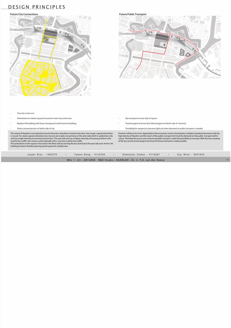
The centre of Haarlem is an important tourist attraction, therefore it needs to be clear how to get, a good orientation
is crucial. To create a good orientation two city axis are create; one primary on the west side which is pedestrian only
and has a high intensity of commercial functions. The east side axis has a higher intensity of housing and forms the
road for bus trac, this means a wide sidewalk with a one lane road for bus trac.
The orientation on the square is focused to the West side by moving the bus terminal to the east side (one former ‘60
building location) thereby opening up the square for pedestrians.
Haarlem will become more depended on the economic centres (Amsterdam, Schiphol, Haarlemmermmer) with the
high density of Haarlem and the reach of the public transport terminal the demand on the public transport will in-
crease. Therefore the access and amount of public transport needs the possibility to increase. With the new locating
of the bus terminal and tangent terminal this future demand is made possible.
D E S I G N P R I N C I P L E S
Future City Connections
- Two city centre axis
- Orientation on station square focused on main city centre axis
- Replace ‘60 building with linear transparent multi function building
- Direct connection axis to North side of city
- Bus transport on east side of square
- South tangent and new East-West tangent on North side of terminal
- Possibility for tangents to become light rail when demand on public transport is needed
Future Public Transport
8/6/2019 Master 1 Q2: Spoorzone Haarlem
http://slidepdf.com/reader/full/master-1-q2-spoorzone-haarlem 12/17CONCLUSION
gijs jasper
INDIVIDUAL
yawen domantas
GENERAL12
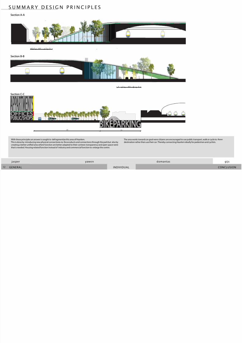
The area works towards an goal were citizens are encouraged to use public transport, walk or cycle to there
destination rather then use their car. Thereby connecting Haarlem ideally for pedestrian and cyclists.
With these principles an answer is sought to defragmentize this area of Haarlem.
This is done by introducing new physical connections via the ecoducts and connections through the park but also by
creating a better unied area where function are better adapted to their context; transparency and open space were
that is needed. Housing related function instead of industry and commercial function to enlarge the centre.
S U M M A R Y D E S I G N P R I N C I P L E S
26,52 3
32.2
1,5
2 6,5 23 3
2165
Section A-A
Section B-B
Section C-C
8/6/2019 Master 1 Q2: Spoorzone Haarlem
http://slidepdf.com/reader/full/master-1-q2-spoorzone-haarlem 13/17MSc 1 • Q1 • AR1U090 R&D Studio • HAARLEM • Dr. ir. F.D. van der Hoeve
J a s p e r B r a s - 1 4 0 2 5 7 9 • Y a w e n D e n g - 4 1 2 3 3 3 6 • D o m a n t a s S t u k a s - 4 1 1 6 2 6 7 • G i j s B r i e t - 4 0 3 1 0 2 4
13
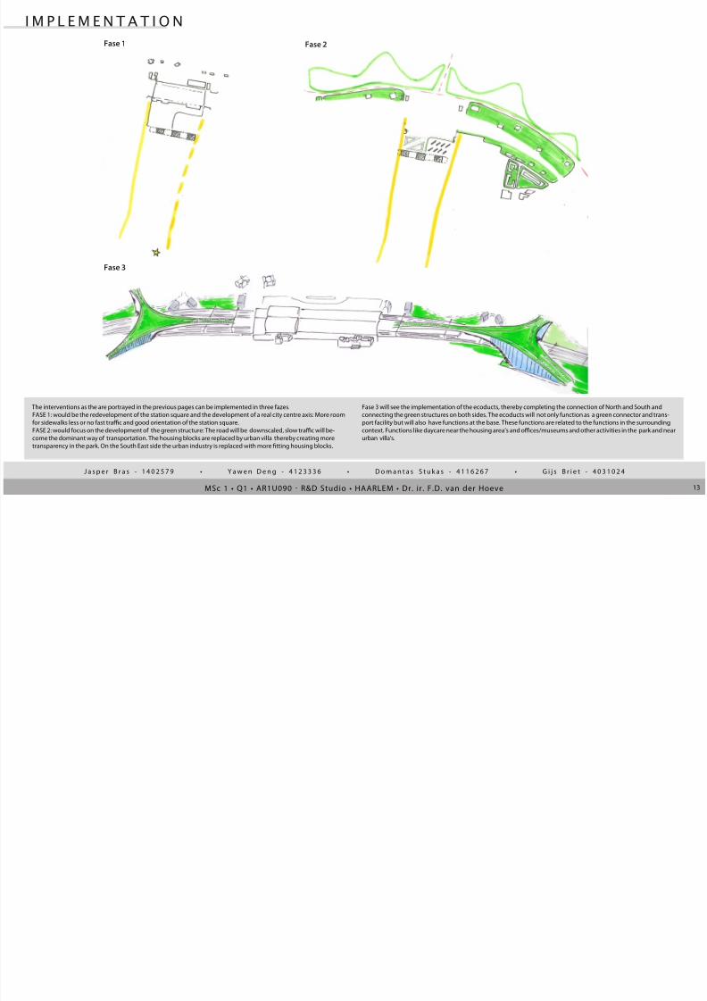
Fase 3 will see the implementation of the ecoducts, thereby completing the connection of North and South and
connecting the green structures on both sides. The ecoducts will not only function as a green connector and trans-
port facility but will also have functions at the base. These functions are related to the functions in the surrounding
context. Functions like daycare near the housing area’s and oces/museums and other activities in the park and near
urban villa’s.
The interventions as the are portrayed in the previous pages can be implemented in three fazes.
FASE 1: would be the redevelopment of the station square and the development of a real city centre axis: More room
for sidewalks less or no fast trac and good orientation of the station square.
FASE 2: would focus on the development of the green structure: The road will be downscaled, slow trac will be-
come the dominant way of transportation. The housing blocks are replaced by urban villa thereby creating more
transparency in the park. On the South East side the urban industry is replaced with more tting housing blocks.
I M P L E M E N T A T I O N
Fase 1 Fase 2
Fase 3

8/6/2019 Master 1 Q2: Spoorzone Haarlem
http://slidepdf.com/reader/full/master-1-q2-spoorzone-haarlem 14/17CONCLUSION
gijs jasper
INDIVIDUAL
yawen domantas
GENERAL14
The station area is tranfomed into a green area that is ready for the intensifying use of the public transport
with the future growth of Schiphol/Amsterdam/Haarlemmermeer. The provides direct connection to t he
north and the centre with the use of green ecoducts that primarily have a transport function but function
also a recreation and viewpoint for the city.
M A S T E R P L A N
A
A
B
B
C
C
New Building
Station Square
Park open area
Current Buildings
Park Trees
Ecoducts
Bus Terminal
Park Path
Water
Traintrack
New Urban Villa’s
Zuid/East Tangent

8/6/2019 Master 1 Q2: Spoorzone Haarlem
http://slidepdf.com/reader/full/master-1-q2-spoorzone-haarlem 15/17MSc 1 • Q1 • AR1U090 R&D Studio • HAARLEM • Dr. ir. F.D. van der Hoeve
J a s p e r B r a s - 1 4 0 2 5 7 9 • Y a w e n D e n g - 4 1 2 3 3 3 6 • D o m a n t a s S t u k a s - 4 1 1 6 2 6 7 • G i j s B r i e t - 4 0 3 1 0 2 4
15
I M P R E S S I O N S
Birds eye view
Perspective Station Square
8/6/2019 Master 1 Q2: Spoorzone Haarlem
http://slidepdf.com/reader/full/master-1-q2-spoorzone-haarlem 16/17CONCLUSION
gijs jasper
INDIVIDUAL
yawen domantas
GENERAL16
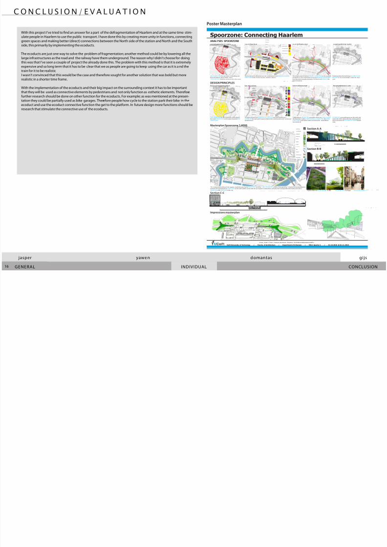
With this project I’ve tried to nd an answer for a part of the defragmentation of Haarlem and at the same time stim-
ulate people in Haarlem to use the public transport. I have done this by creating more unity in functions, connecting
green spaces and making better (direct) connections between the North side of the station and North and the South
side, this primarily by implementing the ecoducts.
The ecoducts are just one way to solve the problem of fragmentation; another method could be by lowering all the
large infrastructures as the road and the railway have them underground. The reason why I didn’t choose for doing
this was that I’ve seen a couple of project the already done this. The problem with this method is that it is extremely
expensive and so long term that it has to be clear that we as people are going to keep using the car as it is a nd thetrain for it to be realistic.
I wasn’t convinced that this would be the case and therefore sought for another solution that was bold but more
realistic in a shorter time frame.
With the implementation of the ecoducts and their big impact on the surrounding context it has to be important
that they will be used as connective elements by pedestrians and not only function as esthetic elements. Therefore
further research should be done on other function for the ecoducts. For example; as was mentioned at the presen-
tation they could be partially used as bike garages. Therefore people how cycle to the station park their bike in the
ecoduct and use the ecoduct connective function the get to the platform. In future design more functions should be
research that stimulate the connective use of the ecoducts.
C O N C L U S I O N / E V A L U A T I O N
26,52 3
32 .2
1,5
28 1,51 ,3 1, 5 1, 3
28 1,51,31,5 2,52
2 6 ,5 23 3
Spoorzone: Connecting Haarlem
Delft University of Technology / Faculty of Architecture / Department of Urbanism / MSc1 Quarter 1 / 22-10-2010 & 02-11-2010
Group: Group 4 /Tutor: Frankvan derHoeven /Students: Gijs Brië[email protected]
A
A
B
B
C
C
NewBuilding
Station Square
Park open area
CurrentBuildings
Park Trees
Ecoducts
BusTerminal
Park Path
Water
Traintrack
NewUrban Villa’s
Zuid/EastTangent
u l i t i in c
C h r c t r i t i c H u i n
Un t ti n Ur n I n u t r
r r i r Cr t i n H u
ANALYSES SPOORZONE
DESIGN PRINCIPLES
currentconnection to centre
NewBuilding
StationSquare
Parkopenarea
CurrentBuildings
ParkTrees
Ecoducts
BusTerminal
ParkPath
Water
Traintrack
NewUrbanilla’s
Zuid/EastTangent
QualitygivingOces
CharactaristicHousing
UnttingUrbanIndustry
BarrierCreatingHouses
current functions current infrastructure current pedestrian routes
BAD CONNECTIONthe city centre, ‘60 building andbusterminalform abarrier.Main routes
LACK FUNCTIONtherefore unclearroute to the centre.
The functionsin the Bolwerken are not contribution to an HARMONIOUS GREENSTRUCTURE forthe city,the housing stripfrom abarrier.
The infrastructure formsthe PRIMARY CONNECTIONto the westsideof Haarlem en the sea.Thislarge structure PREVENTS SLOW TRAFFIC
from the station to easily connectto the North and SEPARATESthegreen structures.
Pedestriansfrom the North have NO DIRECT CON-NECTION to the centre,bridges endat the busy
road.
Highline NewYork
26,52 3
3 .
1,5
28 1,51, 31 ,5 1, 3
28 1,51,3 1,5 2,52
2 6 ,5 23 3
152570
Masterplan Spoorzone 1:4000
Section A-A
Section B-B
NewBuilding
StationSquare
Parkopenarea
CurrentBuildings
ParkTrees
Ecoducts
BusTerminal
ParkPath
Water
Traintrack
NewUrbanilla’s
Zuid/EastTangent
u a l ityg i v i ng ce s
CharactaristicHousing
UnttingUrbanIndustry
BarrierCreatingHouses
future functions future infrastructure future pedestrian routesfuture connection to centre
TWO URBAN AXES to city centre,one connecting tothe north.ORIENTATION on the square towards MAINCENTRE AXES.
The park consistof one HARMONIOUS FUNCTION were work/publicuse isALTERNATEDby open green spaces.Urban centre axesfocuseson 24/7 use by variating functions.
Trachasbeen REDIRECTED aroundthe centre via DOWN SCALING the Bolwerken roadto a GREEN AVENUE, CONNECTINGthe GREENSTRUCTURES andcreating betterconnectionsfor slowtracto/
from the North
ECOBRIDGES connectthe green on the north andsouth side of the station,thereby creating adirectgreen connection to STATION PLATFORMS forboth
sides.
Impressions masterplan
Section C-CParklife GroningenUs e: Ec ob ri dge Us e: Ur ban v ill a Us e: Ce nt re c it y axe s
The station areaistranfomed into agreen areathatisready forthe INTENSIFYING use of the PUBLIC TRANSPORT with the future growth of Schiphol/Amsterdam/Haarlemmermeer.The providesdirect CONNECTIONto the north andthe centre with the use of green ecoductsthat primarily have atransportfunction butfunction also a
RECREATIONand VIEWPOINT forthe city.
Poster Masterplan

8/6/2019 Master 1 Q2: Spoorzone Haarlem
http://slidepdf.com/reader/full/master-1-q2-spoorzone-haarlem 17/17
J a s p e r B r a s - 1 4 0 2 5 7 9 • Y a w e n D e n g - 4 1 2 3 3 3 6 • D o m a n t a s S t u k a s - 4 1 1 6 2 6 7 • G i j s B r i e t - 4 0 3 1 0 2 4
SOURCES:
Google corp., ‘Bird’s eye view Haarlem, streetview prinsen bolwerken, Folkingestraat Groningen, Oosterstraat Groningen, ’ . Google Maps, website: hp://maps.google.com/
Prof. dr. Ir. V.J. Meyer, prof dr. Ir. C.M. Steenberen (2010), ‘Quaterguide AR1U090 – Analysis and Design of the City Form’ . Del: Del University Press,
Archdaily pics., Arrhov Frick: Parklife, ’ . Archdaily: www. archdaily.com
L E G E N D