TFL 4 Bk. 3 - gov.bc.ca · 1993 20 1407 295 1413 15 6 83 265E&N 81E&N 425 60E&N 83 E&N ... 79E&N...
1
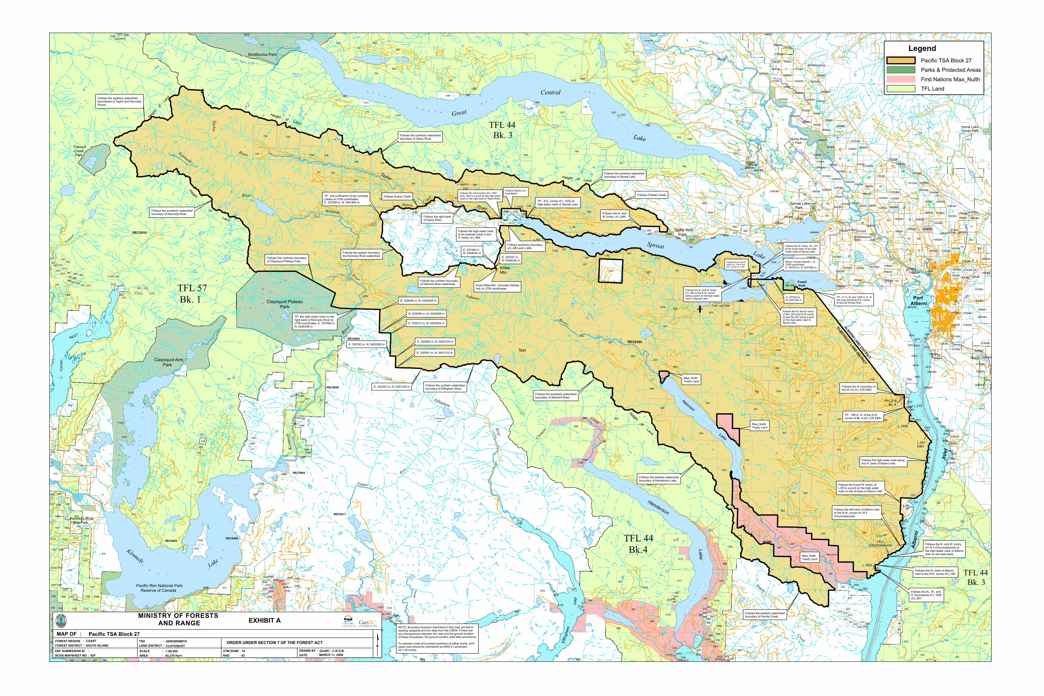
1 657 617 657 614 204E&N 629 937 631 935 5 882 879 720 616 544 877 780 878 860 779 761 500 838 713 768 793 792 855 250 570 896 550 564 845 563 555 562 561 501 873 840 841 843 876 549 872 927 930 871 766 893 903 565 895 894 568 360 938 718 886 794 714 839 767 556 359 944 784 781 844 884 258E&N 554 833 788 785 789 408 847 880 251 358 613 834 7 751 786 557 885 748 923 2173 790 749 777 120E&N 787 6 374 245 887 1211 1019 1220 40 889 569 545 48 4 9 883 69 1087 862 750 875 1215 2 1020 547 546 375 1245 1216 897 3 618 1212 940 859 904A 791 1218 1214 648 257E&N 783 1213 622 874 1088 266 615 41 783 252 36 52 10 56 39 29 263E&N 26 38 23 24 51 197E&N 34 32 50 28 61 20 27 947 12 65 262E&N 14 37 33 53 45 46 13 17 16 30 791 31 733 18 268E&N 59 58 650 35 25 19 630 83E&N 15 21 1548 42 612 1543 951 11 1389 259E&N 715 366 22 1549 313 1542 1544 103E&N 124 1018 1081 683 1021 42AE&N 870 684 1412 1547 948 1545 950 1083 267 1386 952 1319 1321 1425 1421 1320 1423 1496 1025 1396 1411 1395 949 1410 269E&N 80E&N 1318 1414 946 407 2091 1415 1993 420 1407 295 1413 1516 83 265E&N 81E&N 425 60E&N 83E&N 76E&N 166E&N 88E&N 84E&N 77E&N 98E&N 71E&N 85E&N 109E&N 507 91E&N 1218A 432 1387 94E&N 72E&N 497 105E&N 74E&N 92E&N 78E&N 55E&N 82E&N 1614 86E&N 54E&N 126E&N 266E&N 1385 1397 112E&N 79E&N 102E&N 503 1082 252E&N 138E&N 111E&N 116E&N 1497 113E&N 1422 195E&N 49 249E&N 48 151E&N 133E&N 103E&N 132E&N 123E&N 100E&N 117E&N 171E&N 129E&N 194E&N 122E&N 164E&N 157E&N 144E&N 154E&N 121E&N 106E&N 139E&N 1498 73AE&N 161E&N 167E&N 135E&N 99E&N 108E&N 130 181E&N 145E&N 172E&N 670 93E&N 273E&N 514 372 1023 162E&N 163E&N 255E&N 613 449 562 179E&N 160E&N 328 234E&N 169E&N 976 319 518 335 978 143E&N 294 389 455 977 1230 326 229G 526 256E&N 305 1248 349 522 348 276E&N 293 2089 1520 333 321 350 521 1062 375 229G 539 454 2160 362 379 153E&N 107E&N 1546 390 538 413 324 388 1079 417 327 304 176E&N 97E&N 170E&N 2025 1282 1587 519 318 1486 2033 1853 137E&N 1283 1491 245E&N 258G 2054 2055 1487 156E&N 1279 1490 302 525 2037 1489 535 1392 1105 1106 358 437 267E&N 536 253E&N 290E&N 261G 75E&N 2173 148E&N 95E&N 96E&N 90E&N 146E&N 260E&N 115E&N 128E&N 140E&N 125E&N 2A 1424 1983 1408 57E&N 790 1024 127E&N 165E&N 149E&N 733 1409 295E&N 141E&N 589 101E&N 590 193E&N 279E&N 168E&N 1394 110E&N 1393 1688 880 297E&N 1013 152E&N 134E&N 136E&N 452 271E&N 287E&N 289G 373 142E&N 487 524 282E&N 495 1427 232 320 523 688 300 260G 303 158E&N 453 192E&N 277G 1855 387 278G 1590 600 975 299 2104 1588 1281 301 264E&N 288G 1586 1391 345 153E&N 298 307E&N 261E&N 1854 1280 1107 344 1222 364 1022 325 2103 246E&N 361 2057 280E&N 159E&N 136G 762 527 2178 2039 314 1686 1672 2056 322 292G 520 270E&N 2102 2051 510 755 1499 836 410 1495 288E&N 733 449 1684 1685 1675 1658 311 280G 741 291E&N 1677 274E&N 272E&N 196E&N 312 1655 2092 290E&N 2177 1518 252G 284E&N 284G 290G 756 275E&N 1488 283E&N 687 1589 2053 1674 1856 380 2034 1059 599 1609 619 1657 807 567 979 771 611 294G 448 162G 1857 279G 2052 286G 285E&N 293E&N 680 119 2027 980 1673 293G 537 2035 281E&N 346 764 101G 102G 1803 278E&N 1624 104G 386 365 281G 2090 447 1960 172E&N 2038 516 1970 386 1656 291G 2101 118 953 47 369 738 2079 1623 299E&N 2072 298E&N 2093 587 2004 66E&N 1960 2028 103G 370 502 296G 391 2100 504 446 588 802 1596 500A 1960 377 111 332 2179 2180 2131 282G 351 1960 2058 505 300E&N 371 378 772 868 298G 295G 294E&N 296E&N 376 2011 310E&N 673 987 163G Clayoquot Plateau Park Clayoquot Arm Park Tranquil Creek Park Height of Land Height of Land Follows the westerly watershed boundaries of Taylor and Kennedy Rivers. Follows the southerly watershed boundary of Kennedy River. Strathcona Park Kennedy River Bog Park Pacific Rim National Park Reserve of Canada TFL 57 Bk. 1 Height of Land Follows the northerly boundary of Clayoquot Plateau Park. Horne Lake Caves Park TFL 44 Bk. 3 REC0464 REC5910 REC6403 REC6400 Legend Pacific TSA Block 27 Parks & Protected Areas First Nations Maa_Nulth TFL Land NOTE: Boundary locations described on this map are tied to existing cadastral and trim data from the LRDW. If there are any discrepancies between the map and the ground location of these boundaries, the ground location shall take precidence. To maintain scale and present positions of callup boxes, print paper size should be maintained as ANSI E Landscape. 24 x 36 inches Great Central Inlet TOFINO INLET Kennedy Cr. Tranquil Cr. Taylor River Kennedy River Follows the northerly watershed boundary of Taylor River TP- the high-water mark on the right bank of Kennedy River at UTM coordinates: E: 327656 m, N: 5455338 m E: 329456 m, N: 5455283 m E: 329408 m, N: 5453659 m E: 330212 m, N: 5453634 m E: 330163 m, N: 5452026 m E: 330564 m, N: 5452104 m E: 330541 m, N: 5451210 m E: 332333 m, N: 5451156 m Follows the southerly watershed boundary of Nahmint River. Follows the easterly watershed boundary of Henderson Lake. Maa_Nulth Treaty Land RP7668 Follows the easterly watershed boundary of Handy Creek. Follows Friesen Creek Follows the N. and W. bndry. of L.946 TP - S.E. corner of L.1022 at high-water mark of Sproat Lake. Follows District Lot boundaries Follows southerly boundary of L.683 and L.684. Follows the right bank of Taylor River. Follows the high-water mark of an unamed creek to the S. bndry. of L.684. Follows the N. and W. bndry of L.375 to the N.E. corner of L.364 Follows the N. and W. bndry. of L.364 to the S.W. corner being a point on the high-water mark of Sproat Lake. E: 357023 m N: 5457380 m Bndry. crosses Sproat L. to UTM coordinates; E: 357023 m, N: 5457380 m. Follows the W. bndry. of L.373 to the south bank of the high -water mark of Sproat Lake. Follows the W. and N. bndry. of Sec. 80 to the N.W corner of said Sec.80, being a point on the high-water mark of Sproat Lake. TP - 21 m. N. and 1292 m. E. of the most southerly S.E. corner of Sec.89 (Fossli Park. ALBERNI LAND DISTRICT CLAYOQUOT LAND DISTRICT Follows the N.and W. bndry. of L.69 to a point on the high-water mark on the W.bank of Alberni Inlet. Follows the left bank of Alberni Inlet to the N.W. corner of I.R.4 (Chuchakacook). Follows the N. and W. bndry. of I.R.4 (Chuchakacook) to the high-water mark of Alberni Inlet on the west bank. Follows the W. bank of Alberni Inlet to the N.E. corner of L.165. Follows the N., W., and S. boundaries of L.1655 of L.657. Stump River Park Sproat Lake Park Taylor Arm Park Height of Land Sec.80 TFL 44 Bk. 3 TFL 44 Bk.4 Follows the N. boundary of the W.1/2 of L.276 E&N. TP - 196 m. S. of the S.W. corner of Bk. A of L.276 E&N. Follows the high-water mark along the W. bank of Alberni Inlet. Follows the northerly watershed boundary of Sproat Lake. Height of Land Fossli Park REC6394 REC5940 REC0217 REC6405 Follows Sutton Creek Follows the northern boundary of Nahmint River watershed. TP - the confluence of two unamed creeks at UTM coordinates; E: 327656 m, N: 5461865 m Follows the eastern boundary the Kennedy River watershed. E: 337480 m N: 5458434 m E: 337547 m N: 5458226 m Kiltsa Mtn. From Kiltsa Mtn., boundary follows HoL to UTM coordinates. REC0015 L.364 L.1022 Follows the west bndry's of L.1062 and L.684 to a point on the high water mark on the right bank of Taylor River. L.1655 L.69 L.297 E&N L.1658 L.270 L.276 Bk, A I.R.4 (Chuchakacook) Lake Sproat Lake Taylor River Alberni Nahmint Lake Henderson Lake Effingham Inlet Toquart Port Alberni L.783 L.85 L. 372 L.86 L.779 L.84 Sutton Creek Kennedy River Nahmint River Handy Creek Clemens Creek Sec.89 Toquart River Effingham River Follows the northern watershed boundary of Effingham River. Cats Ears Creek Effingham Lake River Kennedy Lake Text MINISTRY OF FORESTS AND RANGE EXHIBIT A SCALE AREA : : 64,279 Ha+/- ESF SUBMISSION ID BCGS MAPSHEET NO : : 92F FOREST REGION FOREST DISTRICT : : SOUTH ISLAND COAST MAP OF : Pacific TSA Block 27 TSA LAND DISTRICT : : CLAYOQUOT ARROWSMITH ORDER UNDER SECTION 7 OF THE FOREST ACT UTM ZONE NAD : : 83 10 DRAWN BY DATE : : MARCH 11, 2009 GeoBC - C.R.G.B. ¢ 1:80,000 Maa_Nulth Treaty Land Maa_Nulth Treaty Land
Transcript of TFL 4 Bk. 3 - gov.bc.ca · 1993 20 1407 295 1413 15 6 83 265E&N 81E&N 425 60E&N 83 E&N ... 79E&N...
1
657
617
657
614
204E&N
629
937
631
935
5
882879
720
616
544
877
780
878
860
779
761
500
838
713
768
793
792
855
250
570
896
550
564
845
563555
562561
501
873
840
841
843
876
549
872
927
930
871
766
893
903
565
895
894
568
360
938
718
886
794
714
839
767
556
359
944
784
781
844
884
258E&N
554
833
788
785
789
408
847
880
251
358
613
834
7
751
786
557
885
748
923
2173
790
749
777
120E&N
787
6
374
245
887
1211
1019
1220
40
889
569
545
48
4
9
883
69
1087
862
750
875
1215
21020
547 546
375
1245
1216
897
3
618
1212
940
859
904A
791
1218
1214
648
257E&N
783
1213
622
874
1088
266
615
41
783
252
36
52
10
56
39
29
263E&N
26
3823
24
51
197E&N
34
32
50
28
61
20
27
947
12
65
262E&N
14
37
33
53
45
46
13
17
16
30791
31
733
18
268E&N
59
58
650
35 25
19
630
83E&N
1521
1548
42612
1543
95111
1389
259E&N
715
366
22
1549
313
443
427
430
439
1542
1544
428
441
431
419
442429
103E&N
440
124
1018
426
1081
683
1021
42AE&N
870
684
1412
1547
948
1545
950
13101311
1083
1312
267
1313
1386
952
1314
13191321
1316
1425
1421
1320
1423
1496
1315
1025
1396
1411
1395
949
1410
269E&N
80E&N
1318
1414
946
438
407
2091
1415
1993
420
1407
295
1413
1516 83
265E&N
81E&N
425
60E&N
83E&N
76E&N
166E&N
88E&N
84E&N
77E&N
98E&N
71E&N
85E&N
109E&N
1317
507
91E&N
1218A
432
1387
94E&N
72E&N
497
105E&N
74E&N
92E&N
78E&N55E&N
82E&N
1614
86E&N
54E&N
126E&N
266E&N
1385
1397
112E&N
79E&N
102E&N
503
1082
252E&N
138E&N
111E&N
116E&N
1497
113E&N
1422
195E&N
49
249E&N
48
151E&N
133E&N
103E&N
132E&N
123E&N
100E&N
117E&N
171E&N
129E&N
194E&N
122E&N
164E&N
157E&N
144E&N
154E&N
121E&N
106E&N
139E&N
1498
73AE&N
161E&N
167E&N
135E&N
99E&N
108E&N
130
181E&N
145E&N
172E&N
670
93E&N
273E&N
514
372
1023162E&N 163E&N
255E&N
613
449
562
179E&N
160E&N
328
234E&N
169E&N
976
319
518
335
978
143E&N
294
389
455
977
1230
326
229G
526
256E&N
305
1248
349
522
348
276E&N293
2089
1520
333
321
350
521
1062
375
229G
539
454
2160
362
379
153E&N
107E&N
1546
390
538
413
324
388
1079
417
327
304
176E&N
97E&N
170E&N
2025
1282
1587
519
318
1486
2033
1853
137E&N
1283
1491
245E&N
258G
2054
2055
1487
156E&N
1279
1490
302 525
2037
1489
535
1392
11051106
358
437
267E&N
536
253E&N
290E&N
261G
75E&N
2173
148E&N
95E&N 96E&N
90E&N
146E&N
260E&N
115E&N
128E&N
140E&N
125E&N
2A
1424
659
1983
1408
57E&N
790
1024
127E&N
165E&N
149E&N
733
1409
295E&N
141E&N
589
101E&N
590
193E&N
279E&N
168E&N
1394
110E&N
1393
1688
880
297E&N
1013
152E&N
134E&N
136E&N
452
271E&N
287E&N
289G
373
142E&N
487
524
282E&N
495
1427
232
320
523
688
300
260G
303
158E&N
453
192E&N
277G
1855
387
278G
1590
600
975
299
2104
1588
1281
301
264E&N
288G
1586
1391
345
153E&N
298
307E&N
261E&N
1854
1280
1107
344
1222
364
1022
325
2103
246E&N
361
2057
280E&N
159E&N
136G
2073
762
527
2178
2039
314
1686
1672
2056
322
292G
520
270E&N
2102
2051
510
755
1499
836
382
410
1495
288E&N
1626
733
449
1684
1685
1675
1658
311
280G
741
1628
291E&N
1677
274E&N
272E&N196E&N
312
1655
2092
290E&N
2177
1518
252G
284E&N
284G
1597
290G
756
2078
275E&N
1488
283E&N
687
1589
2053
1674
1856
380
2034
1059
599
1609
619
1657
807
567
979
771
611
1519
294G
448
162G
1857
279G
2052
286G
285E&N
293E&N
680
119
2027
980
1673
293G
537
2035
281E&N
346
764
101G
102G
1803
278E&N
1624
677
104G
386
381365
281G
660
2090
447
1960
172E&N
2038
516
1970
386
1656
1964
291G
2101
118
953
47
369
738
2079
1623
299E&N
2072
298E&N
2093
1093587
412
2004
66E&N
1960
2028
676
103G
370 502
296G
391
2100
504
446
588
802
1596
500A
1960
377
111
332
2179
2180
2131
282G
351
1960
2058
505
300E&N
371
378
772
868
298G
295G
294E&N
296E&N
376 2011
310E&N
673
987
163G
Clayoquot Plateau Park
Clayoquot Arm Park
Tranquil Creek Park
Height
ofLand
Height
of L
andFollows the westerly watershedboundaries of Taylor and KennedyRivers.
Follows the southerly watershedboundary of Kennedy River.
Strathcona Park
Kennedy River Bog Park
Pacific Rim National Park Reserve of Canada
TFL 57 Bk. 1
Height of Land
Follows the northerly boundaryof Clayoquot Plateau Park.
Horne LakeCaves Park
TFL 44 Bk. 3
REC0464
REC5910
REC6403 REC6400
LegendPacific TSA Block 27Parks & Protected AreasFirst Nations Maa_NulthTFL Land
NOTE: Boundary locations described on this map are tied toexisting cadastral and trim data from the LRDW. If there areany discrepancies between the map and the ground locationof these boundaries, the ground location shall take precidence.To maintain scale and present positions of callup boxes, printpaper size should be maintained as ANSI E Landscape.24 x 36 inches
Great
Central
Inlet
TOFIN
O
INLET
Kenn
edy
Cr.
Tranquil
Cr.
Taylor
RiverKennedy
River
Follows the northerly watershedboundary of Taylor River
TP- the high-water mark on the right bank of Kennedy River atUTM coordinates: E: 327656 m,N: 5455338 m
E: 329456 m, N: 5455283 m
E: 329408 m, N: 5453659 m
E: 330212 m, N: 5453634 m
E: 330163 m, N: 5452026 m E: 330564 m, N: 5452104 m
E: 330541 m, N: 5451210 m
E: 332333 m, N: 5451156 m
Follows the southerly watershedboundary of Nahmint River.
Follows the easterly watershedboundary of Henderson Lake.
Maa_NulthTreaty Land
RP7668
Follows the easterly watershedboundary of Handy Creek.
Follows Friesen Creek
Follows the N. and W. bndry. of L.946
TP - S.E. corner of L.1022 athigh-water mark of Sproat Lake.
Follows District Lot boundaries
Follows southerly boundary of L.683 and L.684.
Follows the right bankof Taylor River.
Follows the high-water mark of an unamed creek to theS. bndry. of L.684.
Follows the N. and W.bndry of L.375 to the N.E. corner of L.364
Follows the N. and W. bndry.of L.364 to the S.W. cornerbeing a point on the high-watermark of Sproat Lake. E: 357023 m
N: 5457380 m
Bndry. crosses Sproat L. toUTM coordinates;E: 357023 m, N: 5457380 m.
Follows the W. bndry. of L.373to the south bank of the high-water mark of Sproat Lake.
Follows the W. and N. bndry.of Sec. 80 to the N.W cornerof said Sec.80, being a point on the high-water mark of Sproat Lake.
TP - 21 m. N. and 1292 m. E. ofthe most southerly S.E. cornerof Sec.89 (Fossli Park.
ALBERNI LAND DISTRICT
CLAYOQUOT LAND DISTRICT
Follows the N.and W. bndry. ofL.69 to a point on the high-watermark on the W.bank of Alberni Inlet.
Follows the left bank of Alberni Inletto the N.W. corner of I.R.4(Chuchakacook).
Follows the N. and W. bndry.of I.R.4 (Chuchakacook) to the high-water mark of AlberniInlet on the west bank.
Follows the W. bank of AlberniInlet to the N.E. corner of L.165.
Follows the N., W., and S. boundaries of L.1655of L.657.
Stump River Park
Sproat Lake Park
Taylor Arm Park
Height of Land
Sec.80
TFL 44 Bk. 3
TFL 44 Bk.4
Follows the N. boundary ofthe W.1/2 of L.276 E&N.
TP - 196 m. S. of the S.W.corner of Bk. A of L.276 E&N.
Follows the high-water mark along the W. bank of Alberni Inlet.
Follows the northerly watershedboundary of Sproat Lake.Height of Land
Fossli Park
REC6394
REC5940
REC0217
REC6405
Follows Sutton Creek
Follows the northern boundaryof Nahmint River watershed.
TP - the confluence of two unamedcreeks at UTM coordinates; E: 327656 m, N: 5461865 m
Follows the eastern boundarythe Kennedy River watershed.
E: 337480 mN: 5458434 m
E: 337547 mN: 5458226 m
KiltsaMtn.
From Kiltsa Mtn., boundary followsHoL to UTM coordinates.
REC0015
L.364
L.1022
Follows the west bndry's of L.1062and L.684 to a point on the high watermark on the right bank of Taylor River.
L.1655
L.69
L.297E&N
L.1658
L.270L.276Bk, A
I.R.4(Chuchakacook)
Lake
Sproat Lake
Taylor
River
Albe
rni
Nahmint
Lake
Henderson
Lake
Effing
ham
Inlet
Toquart
PortAlberni
L.783
L.85 L.372
L.86L.779
L.84
Sutton Creek
Kennedy
River
Nahmint
River
Handy
Creek
Clemens
Creek
Sec.89
Toquart
River
Effingham
River
Follows the northern watershedboundary of Effingham River.
CatsEars
Creek
Effingham Lake
River
Kennedy Lake
Text
MINISTRY OF FORESTS AND RANGE EXHIBIT A
SCALEAREA
:: 64,279 Ha+/-
ESF SUBMISSION IDBCGS MAPSHEET NO
:: 92F
FOREST REGIONFOREST DISTRICT
:: SOUTH ISLAND
COASTMAP OF : Pacific TSA Block 27
TSALAND DISTRICT
:: CLAYOQUOT
ARROWSMITH ORDER UNDER SECTION 7 OF THE FOREST ACTUTM ZONENAD
:: 83
10 DRAWN BYDATE
:: MARCH 11, 2009
GeoBC - C.R.G.B. ¢1:80,000
Maa_NulthTreaty Land
Maa_NulthTreaty Land


![jog ]h kljh gby · =HKL 21.510-83 ( KL KW< 4407-83) (\ j_^ . Baf_g_gby N 1, ml\ . IhklZgh\e_gb_f =hkkljhy KKKJ hl 12.12.1984 N 208) =jmiiZ @ 01 Kjhd \\_^_gby k 1 yg\Zjy 1984 ]h^Z](https://static.fdocuments.nl/doc/165x107/5f54c845faac5b545d506a3c/jog-h-kljh-gby-hkl-21510-83-kl-kw-4407-83-j-bafggby-n-1-ml.jpg)