Yolita II - josvddool.nl Info.pdf · Yolita II Route A, 5 dagen (zondag - donderdag) Dag Bezochte...
35
Yolita II Route A, 5 dagen (zondag - donderdag) Dag Bezochte sites 1 Aankomst vliegveld Baltra PM - Seymour Norte 2 AM - León Dormido (San Cristóbal) PM - Cerro Brujo / Isla Lobos (San Cristóbal) 3 AM - Bahía Gardner (Española) PM - Punta Suárez (Española) 4 AM - Santa Fé PM - Plaza Sur 5 AM - Charles Darwin Research Station (Santa Cruz) Transfer vliegveld Baltra Route B, 4 dagen (donderdag - zondag) Dag Bezochte sites 1 Aankomst vliegveld Baltra PM - Los Gemelos (Santa Cruz) 2 AM - Punta Cormorant / Corona del Diablo (Floreana) PM - Post Office Bay (Floreana) 3 AM - Bahía Ballena (Santa Cruz) PM - Cerro Dragón (Santa Cruz) 4 AM - Caleta Tortuga Negra (Santa Cruz) Transfer vliegveld Baltra Route C, 8 dagen (zondag - zondag) Dag Bezochte sites 1 Aankomst vliegveld Baltra PM - Playa las Bachas (Santa Cruz) 2 AM - Bahía Darwin (Genovesa) PM - El Barranco (Genovesa) 3 AM - Bartolomé PM - Bahía Sullivan (Santiago) 4 AM - Humedales / Muro de las Lágrimas (Isabela) PM - Volcán Sierra Negra (Isabela) 5 AM - Bahía Elizabeth (Isabela) PM - Caleta Tagus (Isabela) 6 AM - Bahía Urbina (Isabela) PM - Punta Espinoza (Fernandina) 7 AM - Playa Espumilla (Santiago) PM - Caleta Bucanero (Santiago) / Rábida 8 AM - Daphne Transfer vliegveld Baltra
Transcript of Yolita II - josvddool.nl Info.pdf · Yolita II Route A, 5 dagen (zondag - donderdag) Dag Bezochte...

Yolita II
Route A, 5 dagen (zondag - donderdag)
Dag Bezochte sites 1 Aankomst vliegveld Baltra
PM - Seymour Norte
2 AM - León Dormido (San Cristóbal)
PM - Cerro Brujo / Isla Lobos (San Cristóbal)
3 AM - Bahía Gardner (Española)
PM - Punta Suárez (Española)
4 AM - Santa Fé
PM - Plaza Sur
5 AM - Charles Darwin Research Station (Santa Cruz)
Transfer vliegveld Baltra
Route B, 4 dagen (donderdag - zondag)
Dag Bezochte sites 1 Aankomst vliegveld Baltra
PM - Los Gemelos (Santa Cruz)
2 AM - Punta Cormorant / Corona del Diablo (Floreana)
PM - Post Office Bay (Floreana)
3 AM - Bahía Ballena (Santa Cruz)
PM - Cerro Dragón (Santa Cruz)
4 AM - Caleta Tortuga Negra (Santa Cruz)
Transfer vliegveld Baltra
Route C, 8 dagen (zondag - zondag)
Dag Bezochte sites 1 Aankomst vliegveld Baltra
PM - Playa las Bachas (Santa Cruz)
2 AM - Bahía Darwin (Genovesa)
PM - El Barranco (Genovesa)
3 AM - Bartolomé
PM - Bahía Sullivan (Santiago)
4 AM - Humedales / Muro de las Lágrimas (Isabela)
PM - Volcán Sierra Negra (Isabela)
5 AM - Bahía Elizabeth (Isabela)
PM - Caleta Tagus (Isabela)
6 AM - Bahía Urbina (Isabela)
PM - Punta Espinoza (Fernandina)
7 AM - Playa Espumilla (Santiago)
PM - Caleta Bucanero (Santiago) / Rábida
8 AM - Daphne
Transfer vliegveld Baltra
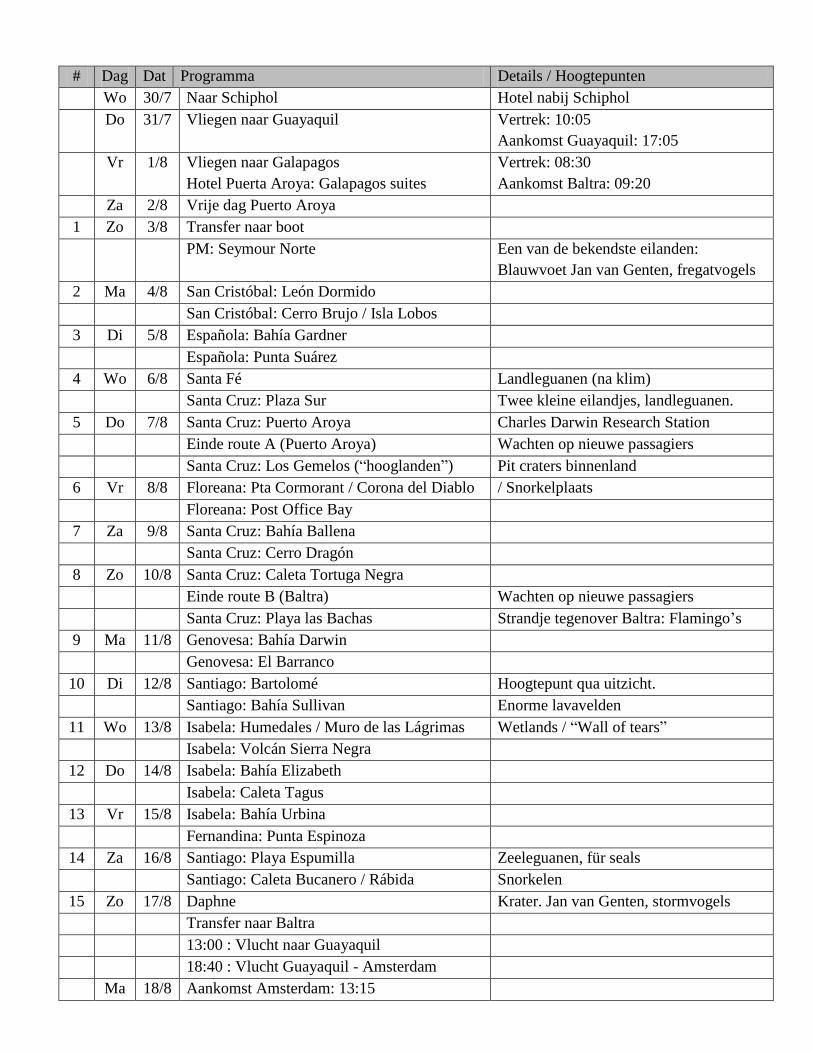
# Dag Dat Programma Details / Hoogtepunten
Wo 30/7 Naar Schiphol Hotel nabij Schiphol
Do 31/7 Vliegen naar Guayaquil Vertrek: 10:05
Aankomst Guayaquil: 17:05
Vr 1/8 Vliegen naar Galapagos
Hotel Puerta Aroya: Galapagos suites
Vertrek: 08:30
Aankomst Baltra: 09:20
Za 2/8 Vrije dag Puerto Aroya
1 Zo 3/8 Transfer naar boot
PM: Seymour Norte Een van de bekendste eilanden:
Blauwvoet Jan van Genten, fregatvogels
2 Ma 4/8 San Cristóbal: León Dormido
San Cristóbal: Cerro Brujo / Isla Lobos
3 Di 5/8 Española: Bahía Gardner
Española: Punta Suárez
4 Wo 6/8 Santa Fé Landleguanen (na klim)
Santa Cruz: Plaza Sur Twee kleine eilandjes, landleguanen.
5 Do 7/8 Santa Cruz: Puerto Aroya Charles Darwin Research Station
Einde route A (Puerto Aroya) Wachten op nieuwe passagiers
Santa Cruz: Los Gemelos (“hooglanden”) Pit craters binnenland
6 Vr 8/8 Floreana: Pta Cormorant / Corona del Diablo / Snorkelplaats
Floreana: Post Office Bay
7 Za 9/8 Santa Cruz: Bahía Ballena
Santa Cruz: Cerro Dragón
8 Zo 10/8 Santa Cruz: Caleta Tortuga Negra
Einde route B (Baltra) Wachten op nieuwe passagiers
Santa Cruz: Playa las Bachas Strandje tegenover Baltra: Flamingo’s
9 Ma 11/8 Genovesa: Bahía Darwin
Genovesa: El Barranco
10 Di 12/8 Santiago: Bartolomé Hoogtepunt qua uitzicht.
Santiago: Bahía Sullivan Enorme lavavelden
11 Wo 13/8 Isabela: Humedales / Muro de las Lágrimas Wetlands / “Wall of tears”
Isabela: Volcán Sierra Negra
12 Do 14/8 Isabela: Bahía Elizabeth
Isabela: Caleta Tagus
13 Vr 15/8 Isabela: Bahía Urbina
Fernandina: Punta Espinoza
14 Za 16/8 Santiago: Playa Espumilla Zeeleguanen, für seals
Santiago: Caleta Bucanero / Rábida Snorkelen
15 Zo 17/8 Daphne Krater. Jan van Genten, stormvogels
Transfer naar Baltra
13:00 : Vlucht naar Guayaquil
18:40 : Vlucht Guayaquil - Amsterdam
Ma 18/8 Aankomst Amsterdam: 13:15

do 31/07 10:05u Amsterdam (AMS) Schiphol do 31/07 17:05u Guayaquil (GYE) KL 751 (13u00m) vr 01/08 08:30u Guayaquil (GYE) vr 01/08 09:20u Galapagos Island (GPS) EQ 191 (1u50m) zo 17/08 13:00u Galapagos Island (GPS) zo 17/08 15:50u Guayaquil (GYE) EQ 192 (1u50m) zo 17/08 18:45u Guayaquil (GYE) ma 18/08 13:15u Amsterdam (AMS) Schiphol KL 755 (12u30m)
Sites:
Officiële Galapagos
site
http://www.galapagospark.org/sitio.php?page=isla_daphne_mayor Supersite !

CERRO BRUJO San Cristóbal (Chatham) Island
Cerro Brujo is located on the north coast of San Cristóbal Island; the trail at this visitors site can
be done in about three hours, including the panga ride. Its main attraction is the powder-like
sandy beach, other than species of flora and fauna.
It is an eroding tuff cone that at several locations is composed of lava type a - a. It is formed by
low-viscosity lava that contains little gas and breaks while it solidifies and is pushed by lava
continuing to flow from behind.
In the lagoon located at Cerro Brujo, the people of Port Baquerizo Moreno mine salt for preserving
cod, beef and tortoise. Today it is a place for watching lake and coastal birds.
Cerro Brujo offers an excellent landscape, where you can see Kicker Rock (geologic formation),
the southern part of Upper San Cristobal and the coast adjacent to Cerro Brujo.
There are two halophytes (Salicornia fructirosa and Scaevola plumieri), these species grow in soils
with high salt content.
Special Indications
It is a good place for swimming and snorkeling.
The beach is an open area, but if walking towards the lake, one should follow a single line
and only cross by the path indicated to avoid destroying the halophytic vegetation of the
place.
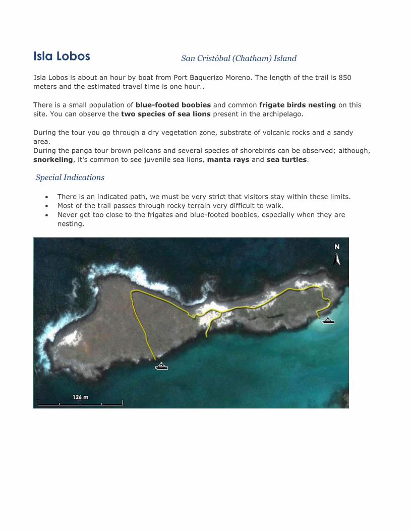
Isla Lobos San Cristóbal (Chatham) Island
ISLA LOBOS (San Christobal)
Isla Lobos is about an hour by boat from Port Baquerizo Moreno. The length of the trail is 850
meters and the estimated travel time is one hour..
There is a small population of blue-footed boobies and common frigate birds nesting on this
site. You can observe the two species of sea lions present in the archipelago.
During the tour you go through a dry vegetation zone, substrate of volcanic rocks and a sandy
area.
During the panga tour brown pelicans and several species of shorebirds can be observed; although,
snorkeling, it's common to see juvenile sea lions, manta rays and sea turtles.
Special Indications
There is an indicated path, we must be very strict that visitors stay within these limits.
Most of the trail passes through rocky terrain very difficult to walk.
Never get too close to the frigates and blue-footed boobies, especially when they are
nesting.
POST OFFICE Floreana Island
Post Office or Post Office Bay is a historic site that recalls the days of the whalers, when they came
for supplies of Galapagos tortoises and water. Presumably a whaling boat captain placed a barrel in
the eighteenth century for those who pass through the bay to leave mail and deliver those with the
same destination. In history the first appearance is on a map of the whaler James Colnett in 1793.
Today, this tradition is alive with tourists visiting the Galapagos. Remind passengers before
disembarking to take any letter or postcard for family members or friends. They do not need
stamps. All they have to do is pick up a letter that is directed to where they live.
At Post Office Bay remains are also found of a Norwegian settlement effort made in the early
twentieth century, who installed a fish cannery.
Another point of interest is a lava tunnel, which is formed when lava cools on the sides and base,
but the core material continues to flow downward. Eventually, the lava, still liquid, leaks and spills
outward leaving a hollow cavity.
Special Indications
The path to the cave (lava tube) is indicated. Take flashlights.
Do not use sunscreens with strong fragrances or bright colors, because in this island there
are a lot of introduced wasps (Polistes versicolor), which are attracted by both, and their
sting is strong.
PUNTA CORMORANT Floreana Island
The visitor site Punta Cormorant is located on the north coast of Floreana Island. The trail has an
approximate distance of 720 meters; the same goes for a lagoon, vistas and a fine sand beach.
In the lagoon one can find a large population of flamingos (Phoenicopterus ruber) and on the
beach a nesting area for sea turtles (Chelonia mydas). Also you can see other species of flora
and fauna.
At Punta Cormorant there are two plant species endemic to the place: Scalesia vellosa and
Lecocarpus pinaffitidus.
The beach landing contains a large amount of olivine crystals, giving it greenish color. These
crystals have been expelled from the wind of nearby tuff cones. The glass was formed when the
magma was still underground. Its content is of magnesium, iron and silica.
There is a beach composed of polished Hermatypic coral sand, the reason for its smooth texture.
These types of areas are ideal for stingrays, which prefer places with surf that has fine sand,
which allows them to escape natural predators.
Special Indications
No swimming from the white sand beach. Be careful not to step on the rays that frequent
this site. A prick on the foot from them can be dangerous.
On the white sand beach, do not step on the sand above the high tide level, because it is a
nesting site for sea turtles and you could crush their eggs, and/or disturb the females that
rest on the shore.
Near the landing site is an ideal place for snorkeling.
Vegetation must be treated carefully, if you want to see the form or smell any plant, do so
without lacerating or breaking them.

Whale Bay (Bahia Ballena) Santa Cruz Island
The visitor site of whale Bay is a cove of green sand at the base of Dragon Hill on the west coast of
Santa Cruz Island. The beach contains a large amount of olivine crystals, the same that originate
from volcanic materials. The crystals were formed when the magma was still underground. The
content is magnesium, iron and silica.
Near the beach there are ceramic relics, which reflect the same antiques of human settlements
that were close to the beach in 1846. According to the accounts of the French captain Genie, a
path originated from this site to the top of the island, which was used to collect fresh water. It is
thought that in this place lived a group of people who were dedicated to the collection of lichen
(Rocella tinctoria), used for tinting.
In this place there existed a small population of tortoises from the island Pinzón, that were
probably taken by whalers or the ancient inhabitants of the place.
Special Indications
Visitors are not allowed to carry out pieces of pottery or other remains that are of
archaeological interest.
The trail up to the top of the mountain requires special physical conditioning and is of
special interest to visitors who wish to make a difficult hike. It is therefore considered
suitable for those visitors with a more adventurous profile, who desire physical effort to
observe and enjoy nature.

CERRO DRAGON (Dragon hill)
Santa Cruz (Indefatigable)
Island
The visitors site at Dragon Hill is located in northwestern Santa Cruz Island, and consists of a trail
that runs through three different environments at just 1,600 m long.
It gets its name because in 1975, was one of the only places in the Santa Cruz Island where there
were land iguanas (Conolophus subcristatus) in healthy state. That same year, the Galapagos
National Park and the Charles Darwin Foundation initiated a program to conserve land iguanas. The
iguanas on North Seymour (originally from Baltra), iguanas from Cartago Bay (Isabela Island) and
iguanas of Santa Cruz Island were studied and then transported to pens especially designed for
these animals to breed in captivity. By 1979 first iguana were born.
The entire iguana population of Cerro Dragon was transported to the Venice Islet to keep the away
from the wild dogs which in those days abounded in the place. Soil from the base of Cerro Dragon
was also transported to Islet to create an appropriate environment for nesting iguanas. It was
necessary to separate the Venice Islet from Santa Cruz Island with a barbed wire fence to prevent
predator dogs from crossing to the Islet, which is separated from the island by a very narrow
channel. Several iguanas that were reproduced in Venice were returned to Cerro Dragon in 1990.
Currently there are no dogs in Cerro Dragon, and the Galapagos National Park Service performs
constant monitoring of cats and donkeys.
In the lagoons at this site, there is shrimp (Artemia salina), the same as is the food of flamingos;
at certain times of year they are more abundant and therefore the population of these birds is
larger. During rainier times the water of the lagoons become too sweet and therefore shellfish
populations decline, and shorebirds also become scarce.
Special Indications
Dragon Hill has been open for tourism since 1993. The repatriation of land iguanas to this
site presents a good option to avoid the overhead of tourism in the South Plaza Island.
The beach is very rocky. At high tide it's a nice place for snorkeling.
At this visiting site you can find vegetation of typical the intertidal zone and dry zone.
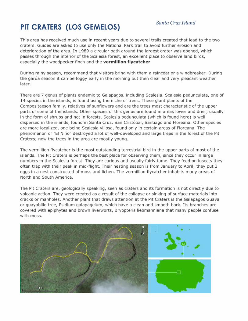
PIT CRATERS (LOS GEMELOS) Santa Cruz Island
This area has received much use in recent years due to several trails created that lead to the two
craters. Guides are asked to use only the National Park trail to avoid further erosion and
deterioration of the area. In 1989 a circular path around the largest crater was opened, which
passes through the interior of the Scalesia forest, an excellent place to observe land birds,
especially the woodpecker finch and the vermillion flycatcher.
During rainy season, recommend that visitors bring with them a raincoat or a windbreaker. During
the garúa season it can be foggy early in the morning but then clear and very pleasant weather
later.
There are 7 genus of plants endemic to Galapagos, including Scalesia. Scalesia pedunculata, one of
14 species in the islands, is found using the niche of trees. These giant plants of the
Compositaeson family, relatives of sunflowers and are the trees most characteristic of the upper
parts of some of the islands. Other species of this genus are found in areas lower and drier, usually
in the form of shrubs and not in forests. Scalesia pedunculata (which is found here) is well
dispersed in the islands, found in Santa Cruz, San Cristóbal, Santiago and Floreana. Other species
are more localized, one being Scalesia villosa, found only in certain areas of Floreana. The
phenomenon of "El Niño" destroyed a lot of well-developed and large trees in the forest of the Pit
Craters; now the trees in the area are mostly young.
The vermillion flycatcher is the most outstanding terrestrial bird in the upper parts of most of the
islands. The Pit Craters is perhaps the best place for observing them, since they occur in large
numbers in the Scalesia forest. They are curious and usually fairly tame. They feed on insects they
often trap with their peak in mid-flight. Their nesting season is from January to April; they put 3
eggs in a nest constructed of moss and lichen. The vermillion flycatcher inhabits many areas of
North and South America.
The Pit Craters are, geologically speaking, seen as craters and its formation is not directly due to
volcanic action. They were created as a result of the collapse or sinking of surface materials into
cracks or manholes. Another plant that draws attention at the Pit Craters is the Galapagos Guava
or guayabillo tree, Psidium galapageium, which have a clean and smooth bark. Its branches are
covered with epiphytes and brown liverworts, Bryopteris liebmanniana that many people confuse
with moss.
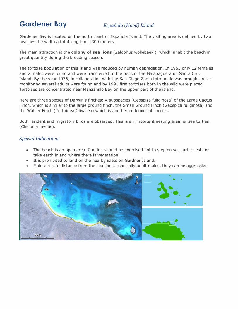
Gardener Bay Española (Hood) Island
Gardener Bay is located on the north coast of Española Island. The visiting area is defined by two
beaches the width a total length of 1300 meters.
The main attraction is the colony of sea lions (Zalophus wollebaeki), which inhabit the beach in
great quantity during the breeding season.
The tortoise population of this island was reduced by human depredation. In 1965 only 12 females
and 2 males were found and were transferred to the pens of the Galapaguera on Santa Cruz
Island. By the year 1976, in collaboration with the San Diego Zoo a third male was brought. After
monitoring several adults were found and by 1991 first tortoises born in the wild were placed.
Tortoises are concentrated near Manzanillo Bay on the upper part of the island.
Here are three species of Darwin's finches: A subspecies (Geospiza fuliginosa) of the Large Cactus
Finch, which is similar to the large ground finch, the Small Ground Finch (Geospiza fuliginosa) and
the Wabler Finch (Certhidea Olivacea) which is another endemic subspecies.
Both resident and migratory birds are observed. This is an important nesting area for sea turtles
(Chelonia mydas).
Special Indications
The beach is an open area. Caution should be exercised not to step on sea turtle nests or
take earth inland where there is vegetation.
It is prohibited to land on the nearby islets on Gardner Island.
Maintain safe distance from the sea lions, especially adult males, they can be aggressive.
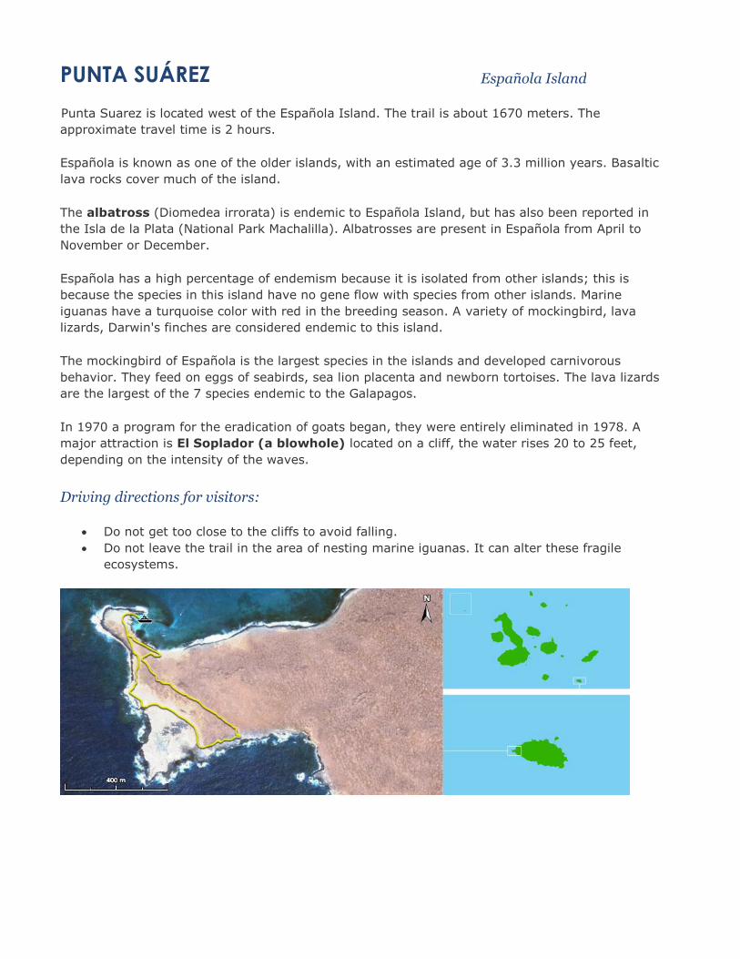
PUNTA SUÁREZ Española Island
Punta Suarez is located west of the Española Island. The trail is about 1670 meters. The
approximate travel time is 2 hours.
Española is known as one of the older islands, with an estimated age of 3.3 million years. Basaltic
lava rocks cover much of the island.
The albatross (Diomedea irrorata) is endemic to Española Island, but has also been reported in
the Isla de la Plata (National Park Machalilla). Albatrosses are present in Española from April to
November or December.
Española has a high percentage of endemism because it is isolated from other islands; this is
because the species in this island have no gene flow with species from other islands. Marine
iguanas have a turquoise color with red in the breeding season. A variety of mockingbird, lava
lizards, Darwin's finches are considered endemic to this island.
The mockingbird of Española is the largest species in the islands and developed carnivorous
behavior. They feed on eggs of seabirds, sea lion placenta and newborn tortoises. The lava lizards
are the largest of the 7 species endemic to the Galapagos.
In 1970 a program for the eradication of goats began, they were entirely eliminated in 1978. A
major attraction is El Soplador (a blowhole) located on a cliff, the water rises 20 to 25 feet,
depending on the intensity of the waves.
Driving directions for visitors:
Do not get too close to the cliffs to avoid falling.
Do not leave the trail in the area of nesting marine iguanas. It can alter these fragile
ecosystems.
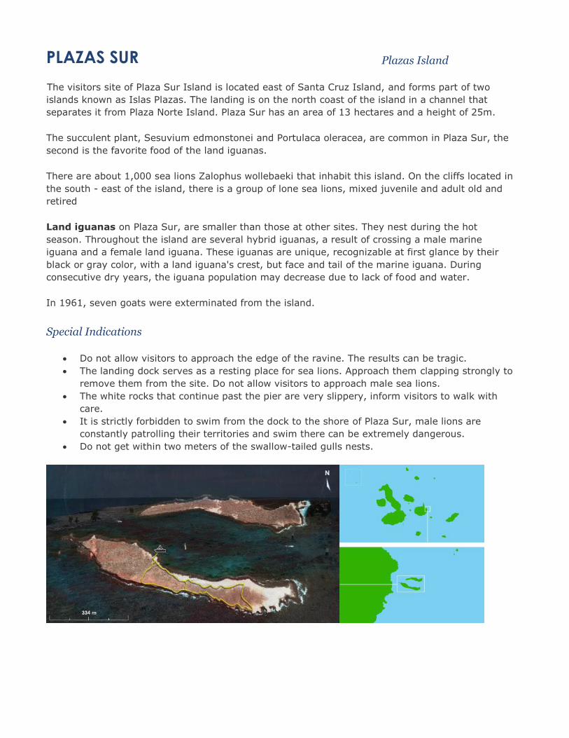
PLAZAS SUR Plazas Island
The visitors site of Plaza Sur Island is located east of Santa Cruz Island, and forms part of two
islands known as Islas Plazas. The landing is on the north coast of the island in a channel that
separates it from Plaza Norte Island. Plaza Sur has an area of 13 hectares and a height of 25m.
The succulent plant, Sesuvium edmonstonei and Portulaca oleracea, are common in Plaza Sur, the
second is the favorite food of the land iguanas.
There are about 1,000 sea lions Zalophus wollebaeki that inhabit this island. On the cliffs located in
the south - east of the island, there is a group of lone sea lions, mixed juvenile and adult old and
retired
Land iguanas on Plaza Sur, are smaller than those at other sites. They nest during the hot
season. Throughout the island are several hybrid iguanas, a result of crossing a male marine
iguana and a female land iguana. These iguanas are unique, recognizable at first glance by their
black or gray color, with a land iguana's crest, but face and tail of the marine iguana. During
consecutive dry years, the iguana population may decrease due to lack of food and water.
In 1961, seven goats were exterminated from the island.
Special Indications
Do not allow visitors to approach the edge of the ravine. The results can be tragic.
The landing dock serves as a resting place for sea lions. Approach them clapping strongly to
remove them from the site. Do not allow visitors to approach male sea lions.
The white rocks that continue past the pier are very slippery, inform visitors to walk with
care.
It is strictly forbidden to swim from the dock to the shore of Plaza Sur, male lions are
constantly patrolling their territories and swim there can be extremely dangerous.
Do not get within two meters of the swallow-tailed gulls nests.

DARWIN BAY Genovesa Island
Tower Island has a shield volcano; the crater is about 600 meters wide at the edges and a depth of
60 meters. The total route of the trail is approximately 1,500 meters. The trail is part coral sand
and the other part is slabs of lava.
Initial highlights are the nesting colonies of the common frigate, the Nazca booby and the
swallow-tailed gulls. We also find here nests of red-footed booby, which is the largest nesting
colony of Galapagos for pelagic bird.
Swallow-tailed gulls feed at night on squid and fish. They usually nests in cliffs and rocks, but at
this place they do so on sand to camouflage their black spotted eggs. When they nest on black
substrate, they add pieces of black coral and on white substrate they add small lava rocks to their
nests.
The Great Frigatebird is abundant here and is one of the main attractions of the island. Genovesa
has no reptiles, possibly due to lack of proper conditions for the nesting of these vertebrates.
The Galápagos Mockingbird (Nesomimus parvulus) and the Large Cactus Finch (Geospiza
conirostris) are tagged because Dr. Peter Grant has made long-term studies of behavior and
evolution of terrestrial birds. The Genovese mockingbirds have been studied for their cooperative
behavior. As for the Large Cactus Finch, on this island there are two sets of the same species that
differ in their singing. Females are attracted to chanting similar to their ancestral males, behavior
that demonstrates the evolutionary divergence within a species.
Special Indications
At this site during high tide, most of the trail is covered with water. Do not wet your shoes,
in order to complete the journey without any discomfort and problems.
Once one crosses the nesting area of the frigates, the trail continues on a platform of lava
and climbs the cliff. Do not step on the vegetation, or get into the area of Salt Bush
(Cryptocarpus pyriformis), the Swallow-Tailed Gulls (Creagrus furcatus) nest under these
bushes and on the beach, where one is likely to step on the birds or their eggs.
The birds on this site are usually very tame and it seems that the proximity of the visitors
do not bothered them much. However, as a rule, keep within 2 feet away.
Genovesa has remained unaltered by man due to its geographic isolation and lack of fresh
water. Be sure not to carry organisms in your clothing or shoes when dry landing, nor any
food, either here or in any other island.
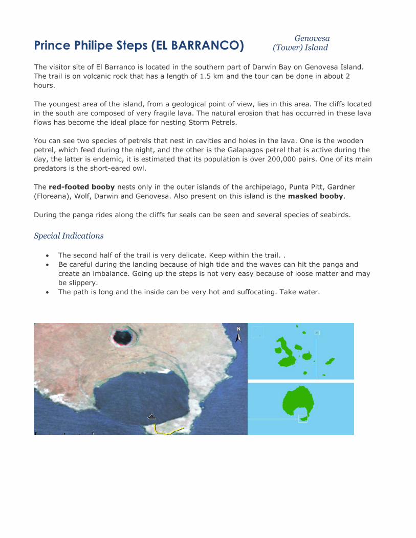
Prince Philipe Steps (EL BARRANCO) Genovesa
(Tower) Island
The visitor site of El Barranco is located in the southern part of Darwin Bay on Genovesa Island.
The trail is on volcanic rock that has a length of 1.5 km and the tour can be done in about 2
hours.
The youngest area of the island, from a geological point of view, lies in this area. The cliffs located
in the south are composed of very fragile lava. The natural erosion that has occurred in these lava
flows has become the ideal place for nesting Storm Petrels.
You can see two species of petrels that nest in cavities and holes in the lava. One is the wooden
petrel, which feed during the night, and the other is the Galapagos petrel that is active during the
day, the latter is endemic, it is estimated that its population is over 200,000 pairs. One of its main
predators is the short-eared owl.
The red-footed booby nests only in the outer islands of the archipelago, Punta Pitt, Gardner
(Floreana), Wolf, Darwin and Genovesa. Also present on this island is the masked booby.
During the panga rides along the cliffs fur seals can be seen and several species of seabirds.
Special Indications
The second half of the trail is very delicate. Keep within the trail. .
Be careful during the landing because of high tide and the waves can hit the panga and
create an imbalance. Going up the steps is not very easy because of loose matter and may
be slippery.
The path is long and the inside can be very hot and suffocating. Take water.

Urbina Bay Isabela Island
The visitor site Urbina Bay is located at the east base of the Alcedo volcano. The trail starts on the
beach where a wet landing is made, the tour is approximately 3200m, and runs through sand
substrates, pumice rock, lava, coral and vegetable formations in a coastal area that has had a lift;
in addition burrows of land iguanas can be seen.
The trail passes through the foundations of what was a coral structure. During the uprising that
occurred in 1954, 6 km of reef were elevated 5 masl, the coast was extended 3/4 of a mile out. It
is said, in that same year and after the uprising, there was an eruption in the northeast side at a
height of 650 m of Alcedo Volcano, but there is no concrete evidence. There is an area where there
rhyolite (igneous rock that occurs at the violent exit to the outside of the earth) on this site where
no vegetation grows due to the acidity that this type of substrate. This extrusive rock forms when
magma of the same chemical structure as granite, acidic or felsic magma, reaches Earth's surface.
It is an ideal place to observe spiny lobster (Panulirus penicillatus) and green (Panulirus gracilis).
Special Indications
Protect your camera equipment well as the landing can be problematic due to the strong
waves that occur often on this site.
Bring water for the hike because the trail is long and the place is very hot.
Do not take pieces of coral. Corals exposed to air will deteriorate quickly and should not be
touched.
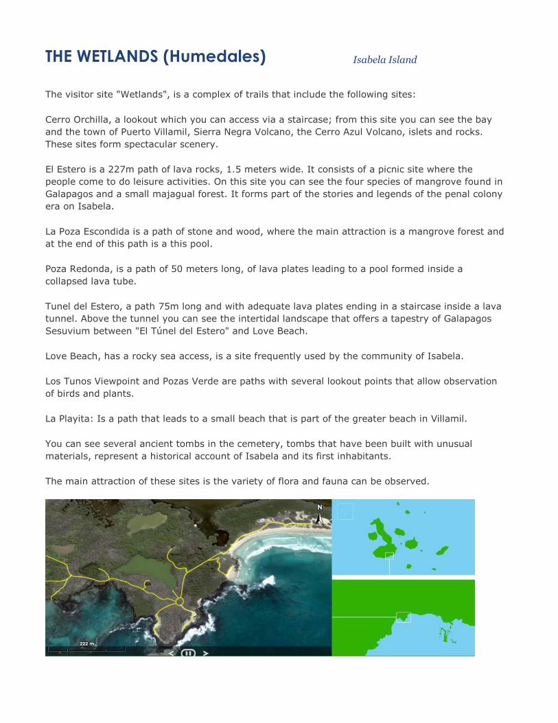
THE WETLANDS (Humedales) Isabela Island
The visitor site "Wetlands", is a complex of trails that include the following sites:
Cerro Orchilla, a lookout which you can access via a staircase; from this site you can see the bay
and the town of Puerto Villamil, Sierra Negra Volcano, the Cerro Azul Volcano, islets and rocks.
These sites form spectacular scenery.
El Estero is a 227m path of lava rocks, 1.5 meters wide. It consists of a picnic site where the
people come to do leisure activities. On this site you can see the four species of mangrove found in
Galapagos and a small majagual forest. It forms part of the stories and legends of the penal colony
era on Isabela.
La Poza Escondida is a path of stone and wood, where the main attraction is a mangrove forest and
at the end of this path is a this pool.
Poza Redonda, is a path of 50 meters long, of lava plates leading to a pool formed inside a
collapsed lava tube.
Tunel del Estero, a path 75m long and with adequate lava plates ending in a staircase inside a lava
tunnel. Above the tunnel you can see the intertidal landscape that offers a tapestry of Galapagos
Sesuvium between "El Túnel del Estero" and Love Beach.
Love Beach, has a rocky sea access, is a site frequently used by the community of Isabela.
Los Tunos Viewpoint and Pozas Verde are paths with several lookout points that allow observation
of birds and plants.
La Playita: Is a path that leads to a small beach that is part of the greater beach in Villamil.
You can see several ancient tombs in the cemetery, tombs that have been built with unusual
materials, represent a historical account of Isabela and its first inhabitants.
The main attraction of these sites is the variety of flora and fauna can be observed.
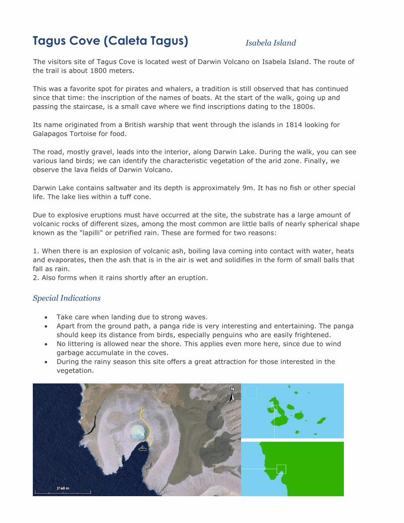
Tagus Cove (Caleta Tagus) Isabela Island
The visitors site of Tagus Cove is located west of Darwin Volcano on Isabela Island. The route of
the trail is about 1800 meters.
This was a favorite spot for pirates and whalers, a tradition is still observed that has continued
since that time: the inscription of the names of boats. At the start of the walk, going up and
passing the staircase, is a small cave where we find inscriptions dating to the 1800s.
Its name originated from a British warship that went through the islands in 1814 looking for
Galapagos Tortoise for food.
The road, mostly gravel, leads into the interior, along Darwin Lake. During the walk, you can see
various land birds; we can identify the characteristic vegetation of the arid zone. Finally, we
observe the lava fields of Darwin Volcano.
Darwin Lake contains saltwater and its depth is approximately 9m. It has no fish or other special
life. The lake lies within a tuff cone.
Due to explosive eruptions must have occurred at the site, the substrate has a large amount of
volcanic rocks of different sizes, among the most common are little balls of nearly spherical shape
known as the "lapilli" or petrified rain. These are formed for two reasons:
1. When there is an explosion of volcanic ash, boiling lava coming into contact with water, heats
and evaporates, then the ash that is in the air is wet and solidifies in the form of small balls that
fall as rain.
2. Also forms when it rains shortly after an eruption.
Special Indications
Take care when landing due to strong waves.
Apart from the ground path, a panga ride is very interesting and entertaining. The panga
should keep its distance from birds, especially penguins who are easily frightened.
No littering is allowed near the shore. This applies even more here, since due to wind
garbage accumulate in the coves.
During the rainy season this site offers a great attraction for those interested in the
vegetation.
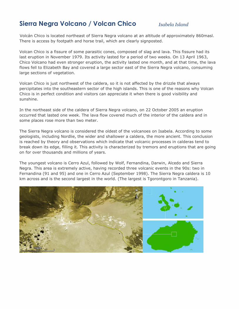
Sierra Negra Volcano / Volcan Chico Isabela Island
Volcán Chico is located northeast of Sierra Negra volcano at an altitude of approximately 860masl.
There is access by footpath and horse trail, which are clearly signposted.
Volcan Chico is a fissure of some parasitic cones, composed of slag and lava. This fissure had its
last eruption in November 1979. Its activity lasted for a period of two weeks. On 13 April 1963,
Chico Volcano had even stronger eruption, the activity lasted one month, and at that time, the lava
flows fell to Elizabeth Bay and covered a large sector east of the Sierra Negra volcano, consuming
large sections of vegetation.
Volcan Chico is just northwest of the caldera, so it is not affected by the drizzle that always
percipitates into the southeastern sector of the high islands. This is one of the reasons why Volcan
Chico is in perfect condition and visitors can appreciate it when there is good visibility and
sunshine.
In the northeast side of the caldera of Sierra Negra volcano, on 22 October 2005 an eruption
occurred that lasted one week. The lava flow covered much of the interior of the caldera and in
some places rose more than two meter.
The Sierra Negra volcano is considered the oldest of the volcanoes on Isabela. According to some
geologists, including Nordlie, the wider and shallower a caldera, the more ancient. This conclusion
is reached by theory and observations which indicate that volcanic processes in calderas tend to
break down its edge, filling it. This activity is characterized by tremors and eruptions that are going
on for over thousands and millions of years.
The youngest volcano is Cerro Azul, followed by Wolf, Fernandina, Darwin, Alcedo and Sierra
Negra. This area is extremely active, having recorded three volcanic events in the 90s: two in
Fernandina (91 and 95) and one in Cerro Azul (September 1998). The Sierra Negra caldera is 10
km across and is the second largest in the world. (The largest is Tgorontgoro in Tanzania).


PUNTA ESPINOZA Fernandina Island
Fernandina is the third largest island in the archipelago and has a single visitor site: Punta
Espinoza, located at the northeastern tip of the island.
Punta Espinoza is a narrow ledge of lava and sand that extends from the base of the volcano to the
sea. There is a vivid description given by Captain Benjamin Morrell that from its anchorage at Bay
Banks witnessed and recorded an eruption of Fernandina in the decade of the 1820s that probably
gave rise to the Point. In 1975, there was an uprising, about 90 cm, which is why the pier built for
landing can only be used during high tide.
The last recorded eruption occurred in May 2005 that lasted three days. The greatest explosive
eruption was in 1968, where two thirds of the caldera floor collapsed inwards to a depth of 300m.
Later there have been eruptions in 1972 and 1973 (mild and effusive) in 1977 (the collapse of the
caldera), in 1986 (mild activity), and 1988 (collapse of the south-east side), in November 1991
(cloud of ash - eruption), 1995 (spewed along a fissure).
Punta Espinoza is a place famous for its large colonies of marine iguanas and as the habitat of
unique species like the flightless cormorant, Galapagos penguin, Galapagos hawk, Galapagos
snake, among others. It is an ideal place to observe the lava cactus (Brachycerus nesioticus),
which grow on young lava and survive with little water.
In the past two land iguanas could be found at this site, but in 1989 they died of starvation. These
iguanas came down from the flanks of the volcano, where they are numerous.
In 1825 an American ship, the Tartar, was anchored in Bay Banks and witnessed a very strong
eruption at Fernandina. The lava reached the sea and the air temperature rose to 50 ° C and the
sea at 40 ° C. After being caught in the bay for a whole night, the ship escaped southward and
while they passed through Fernandina the temperature rose to 65 ° C.
Special Indications
Fernandina is the only island, which has no introduced mammals. Be careful not to
introduce organisms or take food of any kind. The area open to visitors is very fragile, stay
on the trail at all times.
Stay within 2m of the cormorants and penguins.
Land when the tide is high, if the tide is low you can not use the dock, you have to land on
the rocks.


Galapagos Info
Santa Cruz Galapagos Island
The central island in the Galapagos and home to the main port, Puerto Ayora and the Charles Darwin Research Station, which you will visit during your tour. The largest town in Galapagos hosts numerous hotels, restaurants, shops, a post office, small supermarket and two diving companies. A 2½ km walk will bring you to one of the best beaches in the Galapagos, Tortuga Bay. Trips can be made to the Parte Alta, or the high ground behind Puerto Ayora to visit the incredible lava tunnels, the tortoise reserve at Bellavista and the Gemelos, two twin craters. A paved road now crosses the island connecting the port with the main airport in the archipelago, used by the airline TAME, on the island of Baltra. A five minute boat crossing between Baltra and Santa Cruz completes the bus journey.
Santa Cruz, the most frequently visited island in the archipelago, is often described as the point of embarkation for any Galapagos journey. Centrally located, it is only a short ferry ride away from the Baltra airstrip, the most common means of entry to the islands. Here, in the town of Puerto Ayora, travelers can charter small boats to farther-flung Galapagos destinations, and here, too, one mile to the east on the coast of Academy Bay, one may experience a positive result of human habitation-the Charles Darwin Research Station, a haven of scientific inquiry and information and a breeding spot for the famed giant tortoise
Santa Cruz is truly an island of diversity, from its precarious balance of settlement and conservation to its wildly differing landscape, vegetation, and animal life. Reaching almost 3,000 feet above sea level, Santa Cruz offers visible, dramatic changes in its flora and fauna from one area to another. At the sea's edge is a tangled fringe of mangroves and green, salt-tolerant plants. The area just inland from this littoral "zone" is arid forest, dominated by polo santo trees (the name polo santo is Spanish for "holy stick," which refers to this normally leafless (to conserve water), silver-barked plant's characteristic of coming into flower around Christmastime the start of the rainy season) and the Opuntia, or prickly pear cactus. Lava lizards, mockingbirds, and ground finches are the most obvious denizens of this region. Farther inland and upward, the vegetation becomes denser and more varied, slowly becoming transformed into an almost magical, mist-shrouded region of tall trees, covered with mosses and liverworts. This area, originally marked by the native evergreen scalesia, was one of the earliest regions to become cultivated, and consequently much of the zone has given way to pastures and small plantations. Tropical, yet temperate, these beautiful forests are home to the vermilion flycatcher and many species of tree finch. Beyond lies the Miconia (a dense bush endemic to two of the islands) zone, above which, instead of shrubs or trees, looms a prehistoric-looking jungle of ferns, sedges, and grasses, wrapped in fog.
The variety found on Santa Cruz is also geological. In terms of geology, Santa Cruz is relatively old. The "younger" parts of the island are marked by eroded volcanic cones called "cerros' (the most famous being Cerro Crocker). Other features include spatter cones (such as Puntudo) , formed by the "spattering" of molten material from an active volcano, and pit craters, small calderas, of which the Gemelos (or "twins") are the most notable.

Santiago Galapagos Island
Located to the north-west of Santa Cruz Island and is famous for its earlier human use, such as attempts to mine salt and its natural resources; a flamingo lagoon, lava flows at Sullivan Bay and fur seal grottos, to name a few. James Bay is the most visited point on the west side of the island for its salt crater (Puerto Egas), Sugarloaf Volcano (450 m), fur seal grottos and Espumilla Beach with its flamingo lagoon. On the east side of Santiago you will visit Sullivan Bay famous for its conical volcano and for the study of various types of lava rock, some of which is as young as 90 years.
Named after Hector Egas, the owner of an ill-fated salt-mining company during the 1960s, Puerto Egas carves out a corner of James Bay, on the western end of the lava coated island of Santiago. Like many commercial ventures in the Galapagos, this attempt (and its predecessor in the 1 920s) to extract a profitable mineral from the salt lake crater immediately beyond the shiny volcanic fields that make up the coast at Puerto Egas was doomed to failure. Today, a few roads and the remains of abandoned buildings serve as reminders of these abortive efforts.
Most visitors to this area of James Bay come to see the shoreline south of Puerto Egas, with its striated yellow, brown, and black cliffs of tuff stone, or hardened volcanic ash, which has also been eroded, molded, and polished by the sea into coves and elaborately patterned rocky beaches. Hikers on the coastal trail may be privileged to spot whales or dolphins cruising by offshore or a feeding frenzy of hundreds of boobies or pelicans attacking a school of fish. At the end of the trail is a magnificent lava-walled grotto whose shady crevices shelter a small group of fur seals.
Perhaps the single dominant feature of the Puerto Egas / James Bay region is a volcanic cone called Sugarloaf, which rises almost 1,300 feet. Formed as the result of the explosive interaction of hot molten rock and cool seawater, this tuft cone and its 700-foot neighbor to the south produced the sandy layers of volcanic ash visible in the nearby cliffs. To the north and east is a large lava flow (noted by Charles Darwin in his journals in 1835), in which fragments of ceramic pots stashed by buccaneers and dated 1684 were later found establishing an age bracket for this volcanic activity.
The landscape surrounding James Bay is harsh, covered primarily by a sparse forest of polo Santa trees, which is threatened by the large population of feral goats on the island who have consumed all but the most unpalatable and heavily armored of native vegetation. The land is consequently turning into an open savannah. and a herd of coats moving across the island calls to mind wildlife on the plains of East Africa. The National Parks Department hopes to remove most of the goats, but without adequate funds for doing so on this relatively large islands, temporary measures, such as fencing off some areas of native plant life, must suffice.
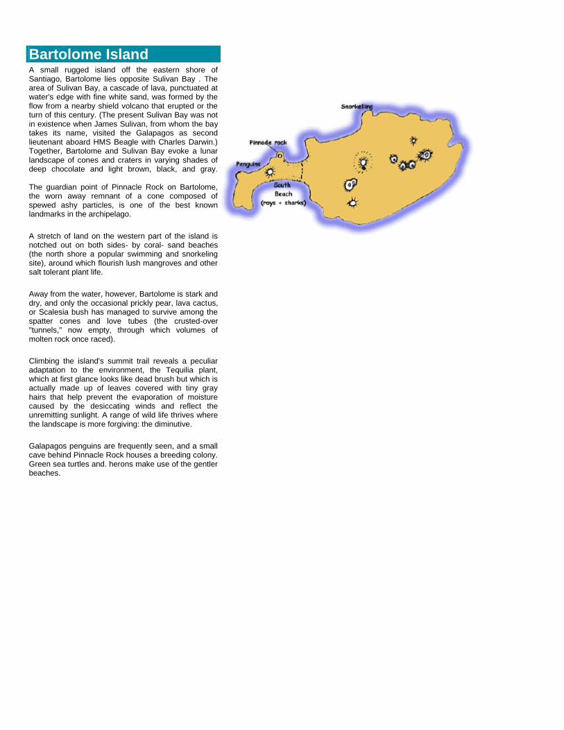
Bartolome Island
A small rugged island off the eastern shore of Santiago, Bartolome lies opposite Sulivan Bay . The area of Sulivan Bay, a cascade of lava, punctuated at water's edge with fine white sand, was formed by the flow from a nearby shield volcano that erupted or the turn of this century. (The present Sulivan Bay was not in existence when James Sulivan, from whom the bay takes its name, visited the Galapagos as second lieutenant aboard HMS Beagle with Charles Darwin.) Together, Bartolome and Sulivan Bay evoke a lunar landscape of cones and craters in varying shades of deep chocolate and light brown, black, and gray. The guardian point of Pinnacle Rock on Bartolome, the worn away remnant of a cone composed of spewed ashy particles, is one of the best known landmarks in the archipelago.
A stretch of land on the western part of the island is notched out on both sides- by coral- sand beaches (the north shore a popular swimming and snorkeling site), around which flourish lush mangroves and other salt tolerant plant life.
Away from the water, however, Bartolome is stark and dry, and only the occasional prickly pear, lava cactus, or Scalesia bush has managed to survive among the spatter cones and love tubes (the crusted-over "tunnels," now empty, through which volumes of molten rock once raced).
Climbing the island's summit trail reveals a peculiar adaptation to the environment, the Tequilia plant, which at first glance looks like dead brush but which is actually made up of leaves covered with tiny gray hairs that help prevent the evaporation of moisture caused by the desiccating winds and reflect the unremitting sunlight. A range of wild life thrives where the landscape is more forgiving: the diminutive.
Galapagos penguins are frequently seen, and a small cave behind Pinnacle Rock houses a breeding colony. Green sea turtles and. herons make use of the gentler beaches.
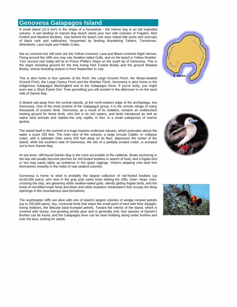
Genovesa Galapagos Island
A small island (10.5 km²) in the shape of a horseshoe - the interior bay is an old imploded volcano. A wet landing on Darwin Bay beach starts your tour with colonies of Frigates, Red Footed and Masked Boobies. Just behind the beach one sees inland tide pools and outcrops of black rock and saltbushes, frequented by feeding Wandering Tattlers, Turnstones, Whimbrels, Lava Gulls and Fiddler Crabs.
Not so common but still seen are the Yellow-crowned, Lava and Black-crowned Night Herons. Flying around the cliffs one may see Swallow-tailed Gulls, and on the beach a Yellow Warbler. Your second visit today will be to Prince Phillip's Steps on the south tip of Genovesa. This is the major breeding ground for the tree loving Red Footed Booby and the ground Masked Booby, whose breeding season is from September to July.
This is also home to four species of the finch; the Large Ground Finch, the Sharp-beaked Ground Finch, the Large Cactus Finch and the Warbler Finch. Genovesa is also home to the indigenous Galapagos Mockingbird and to the Galapagos Dove. If you're lucky, you might even see a Short Eared Owl. Time permitting you will snorkel in the afternoon in on the west side of Darwin Bay.
A distant sail away from the central islands, at the north-eastern edge of the archipelago, lies Genovesa. One of the most pristine of the Galapagos group, it is the remote refuge of many thousands of oceanic birds. Genovesa, as a result of its isolation, remains an undisturbed nesting ground for these birds, who fish in its rich waters, and lacks introduced as well as native land animals and reptiles-the only reptile, in fact, is a small subspecies of marine iguana.
The island itself is the summit of a huge inactive undersea volcano, which protrudes above the water a scant 250 feet. The main vent of the volcano, a large circular Calder, or collapse crater, with a saltwater Glee some 200 feet deep on its floor, depresses the center of the island, while the southern side of Genovesa, the site of a partially eroded crater, is scooped out to form Darwin Bay.
At sea level, cliff-bound Darwin Bay is the most accessible of the calderas. Boats anchoring in the bay will usually become perches for red-footed boobies in search of food, and a frigate bird or two may easily talkie up residence in the upper riggings. Visitors stepping onto land find themselves instantly in the midst of vast seabird colonies.
Genovesa is home to what is probably the largest collection of red-footed boobies (up to140,000 pairs), who nest in the gray polo santo trees dotting the cliffs. Over- head, cries-crossing the slay, are gleaming white swallow-tailed gulls, silently gliding frigate birds, and the hosts of red-billed tropic birds and black and white Audubon shearwaters that occupy the deep openings in the mountainous lava formations.
The southeaster cliffs are alive with one of island's largest colonies of wedge romped petrels (up to 200,000 pairs), tiny, nocturnal birds that share the small point of land with their daylight-loving relatives, the delicate band-trumped petrels. Toward the interior of the island, which is covered with stocky, low-growing prickly pear and is generally arid, four species of Darwin's finches can be found, and the Galapagos dove can be seen bobbing along under bushes and over the lava, looking for seeds.

Isabela Galapagos Island
The largest island in the Galapagos Archipelago and is over 100 kms long and extremely narrow. Six volcanoes are found on Isabella, of which two are over 1,700 meters, which are Wolf and Cerro Azul. The most commonly visited sites are Punta Garcia to see the Flightless Cormorants, Punta Garcia also for Flightless Cormorants, Volcan Alcedo for Land Tortoises, Tagus Cove for Blue Footed Boobies, Flightless Cormorant, Galapagos Penguins and Marine Iguanas, and Urbina Bay for Marine Turtles.
At the mouth of the "sea horse's head" that forms northern Isabella, the small promontory known as Punta Vicente Roca presides over a pair of jewel-like coves. The coves lie on either side of the eroded remains of a tuft, or volcanic ash cone, which make up the point. Facing the ocean is a bay, shielded from the open swells.
The bay is a popular anchorage for boats, from which visitors may transfer to dinghies and ride around the surrounding cliffs-actually the interior walls of a fallen volcano and perhaps into the partly flooded cave.
The area is also a rewarding scuba-diving site, its abundant ocean life the product of cool, nutrient-rich waters up welling off the volcano's steep submarine slopes. On the other side of the point is a secluded cove, accessible from the sea only through water-filled subterranean passages. Sea lions travel through these passageways and gather on the protected beaches of the hidden waters. Large numbers of blue-footed and masked boobies inhabit the point and the sheer cliffs, and flightless cormorants can be seen along the shoreline.
Punta Vicente Roca itself rests on the southwestern edge of Volcano Ecuador. Rising some 2,600 feet, Isabella's sixth volcano is really half a volcano the other half having slid into the oceaneons ago. Travelers rounding Cape Berkeley by boat, heading out from the central islands, are treated to the magnificent cutaway view of the volcano and its caldera.
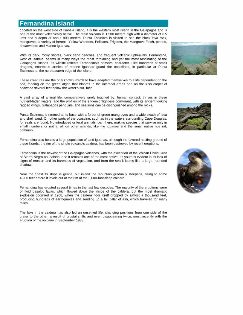
Fernandina Island
Located on the west side of Isabela Island, it is the western most island in the Galapagos and is one of the most volcanically active. The main volcano is 1,500 meters high with a diameter of 6.5 kms and a depth of about 800 meters. Punta Espinoza is visited to see the black lava rock, mangroves, a variety of herons, Yellow Warblers, Pelicans, Frigates, the Mangrove Finch, petrels, shearwaters and Marine Iguanas.
With its dark, rocky shores, black sand beaches, and frequent volcanic upheavals, Fernandina, west of Isabela, seems in many ways the most forbidding and yet the most fascinating of the Galapagos islands. Its wildlife reflects Fernandina's primeval character. Like hundreds of small dragons, enormous armies of marine iguanas guard the coastlines, in particular at Punta Espinosa, at the northeastern edge of the island.
These creatures are the only known lizards to have adapted themselves to a life dependent on the sea, feeding on the green algae that blooms in the intertidal areas and on the lush carpet of seaweed several feet below the water's sur, face.
A vast array of animal life, comparatively rarely touched by, human contact, thrives in these nutrient-laden waters, and the profiles of the endemic flightless cormorant, with its ancient looking ragged wings, Galapagos penguins, and sea lions can be distinguished among the rocks.
Punta Espinosa is rimmed at its base with a forest of green mangroves and a wide swath of lava and shell sand. On other parts of the coastline, such as in the waters surrounding Cape Douglas, for seals are found. No introduced or feral animals roam here, making species that survive only in small numbers or not at all on other islands, like the iguanas and the small native rice rat, common.
Fernandina also boasts a large population of land iguanas, although the favored nesting ground of these lizards, the rim of the single volcano's caldera, has been destroyed by recent eruptions.
Fernandina is the newest of the Galapagos volcanos, with the exception of the Volcan Chico Oreo of Sierra Negro on Isabela, and it remains one of the most active. Its youth is evident in its lack of signs of erosion and its bareness of vegetation, and from the sea it looms like a large, rounded shadow.
Near the coast its slope is gentle, but inland the mountain gradually steepens, rising to some 4,900 feet before it levels out at the rim of the 3,000-foot-deep caldera.
Fernandina has erupted several times in the last few decodes. The majority of the eruptions were of fluid basaltic lavas, which flowed down the inside of the caldera, but the most dramatic explosion occurred in 1968, when the caldera floor itself dropped by almost a thousand feet, producing hundreds of earthquakes and sending up a tall pillar of ash, which traveled for many miles.
The lake in the caldera has also led an unsettled life, changing positions from one side of the crater to the other; a result of crustal shifts and even disappearing twice, most recently with the eruption of the volcano in September 1988..

Darwin Island (Culpepper)
This island is named after Charles Darwin. It has an area of 1.1 km 2 and a maximum altitude of 168 meters. Here fur seals, frigates, marine iguanas, swallow-tailed gulls, sea lions, Whales, marine turtles, dolphins, red footed and masqued boobies can be seen.
Rabida Galapagos Island
A small island just over 2 kms in width and 400 meters at its highest point, located to the south of Santiago Island. Rabida is known for its unusual red colored beaches. The vegetation consists mainly of Opuntia Cactus, Palo Santo tress and scrubby bushes. Upon your wet landing you will probably see various sea lions and after a short hike you will reach the lagoon to see Flamingos and Pelicans.

Baltra GalapagosIsland
The origin of the name is unknown. Area: 27 Km2 Maximum Altitude approximately 100 meters above sea level. We will find animals such as land iguanas, marine iguanas and marine turtles.
For most visitors, Baltra is their entry point into the Galapagos. Once a North American airbase, the airlines TAME and Aerogal flies to and from here on a daily basis. From here you will either catch a five minute bus ride to the dock and embark your yacht, or you'll take a bus to the south of the island, a ten minute journey to the channel that separates Baltra and Santa Cruz. Here a ten minute boat ride brings you to the northern most point on Santa Cruz where a bus will take you across the island arriving forty five minutes later in Puerto Ayora.
Seymour Galapagos Island
Located directly to the north of Baltra Island, Seymour is famous
for its colony of Frigates found on the southwest side of this
small island.
Also found on this island are Blue Footed Boobies, Land
Iguanas, Swallow-tailed Gulls, Pelicans and Red-billed Tropic Birds
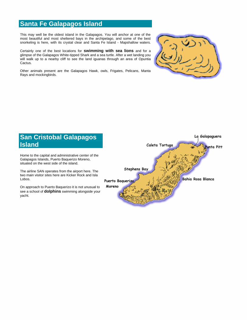
Santa Fe Galapagos Island
This may well be the oldest island in the Galapagos. You will anchor at one of the most beautiful and most sheltered bays in the archipelago, and some of the best snorkeling is here, with its crystal clear and Santa Fe Island - Mapshallow waters.
Certainly one of the best locations for swimming with sea lions and for a
glimpse of the Galapagos White-tipped Shark and a sea turtle. After a wet landing you will walk up to a nearby cliff to see the land iguanas through an area of Opuntia Cactus. Other animals present are the Galapagos Hawk, owls, Frigates, Pelicans, Manta Rays and mockingbirds.
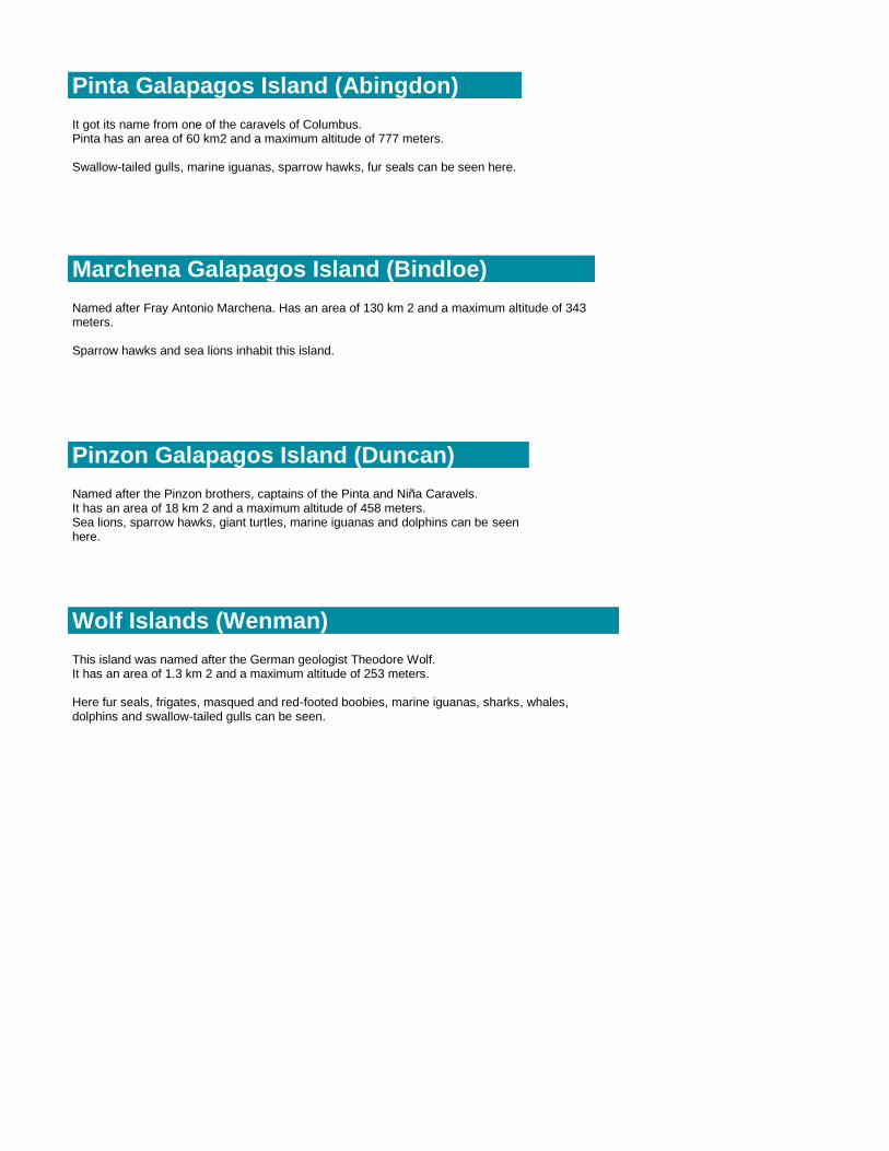
San Cristobal Galapagos Island
Home to the capital and administrative center of the Galapagos Islands, Puerto Baquerizo Moreno, situated on the west side of the island. The airline SAN operates from the airport here. The two main visitor sites here are Kicker Rock and Isla Lobos. On approach to Puerto Baquerizo it is not unusual to
see a school of dolphins swimming alongside your
yacht.

Floreana Galapagos Island
The best known site on this island is Post Office Bay where in the past sailors used to leave and receive their letters in a barrel to be delivered by other sailors coming or going to Europe and North America. The tradition continues - leave your postcard in the barrel and see how long it takes to be delivered - at the same time your guide will go through the postcards that are already in the barrel and if there is a postcard with an address close to your home, please take it with you and mail it when you finish your vacation! Close to Post Office Bay is the place where the first families arrived to live in the Galapagos - your guide will explain the history and mystery of this story.
Your next visit will be to Punta Cormoran, a green olivine beach to see Sea Lions and a short walk past a lagoon to see Flamingos and finally onto a white beach, whose sand is as fine as talcum powder. A good chance to see Rays,
Sea Turtles and Ghost and Sally Lightfoot Crabs. After lunch, you will have a
chance to snorkel at Devil's Crown, an old imploded volcano just off the coast of the main island. As soon as you get in the water, look down! This will be your best chance to see a shark. There is no need to swim as the strong current will pull you all the way round to the other side seeing on your way a great variety of multi-colored reef fish and playful sea lions.
The island of Floreana rests south of Santa Cruz, rising and falling in a proliferation of volcanic cones, which are often gentled by a thin mantle of polo santo forest. The sterner, western part of the island consists of bare lava flows and a striking black sand beach.
At the northeastern corner, however, one finds Punta Cormorant, whose lagoon frequently harbors the elegant flamingo as well as several other species of birds that feed in the still, clouded waters.
Only some five hundred of the proud pink flamingos inhabit the entire Galapagos Islands, spread out over several lagoons and ponds. As conditions dictate, they move from one lagoon to an-other, so that they are rarely seen in groups of more than a few dozen at a time.
Despite their small numbers, flamingos are social breeders and nest together
following an elaborate courtship display during which the birds perform in choreographed "parades" back and forth with their uncles stretched up and feathers fluffed.
Floreana has the most interesting human history of the settled islands, (which encompass Santa Cruz, Isabela, Floreana, and San Cristobal), in addition to being a place of great natural beauty. The first colonist of the Galapagos, an Irishman named Patrick Watkins, is thought to have been stranded on Floreana in 1807 and sub-sisted by selling food supplies to visiting whaling ships.
In 1832 the Galapagos were officially claimed by Ecuador and "Charles" Island was renamed Floreana, after the first president of Ecuador.

Española Island
This is one of the most popular islands visited due to the variety of animals seen here. The two visitor sites are Punta Suarez on the western tip and Gardner Bay on the eastern side. The former offers its visitors spectacular 30 meter high cliffs inhabited by numerous birds; Masked Boobies, Blue Footed Boobies, Galapagos Doves, the indigenous Hood Mockingbird, the Cactus and Warbler
Finches, Waved Albatrosses.
Walking on the edge of the cliffs you will have a spectacular view of the blowhole, a tunnel connected with the sea that spurts a shower of water 15 to 30 meters high.
You will also see sea lions and Marine Iguanas basking in the sun,
and the largest Lava Lizard in the Galapagos. Gardner Bay offers a
fantastic golden beach for walking amongst Sea Lions and fabulous
snorkeling in the Bay.
Plaza Galapagos Island
Located directly east of Santa Cruz Island this is the smallest of the 3 large islands at 1 km by 130 meters. After a dry landing your hike will you from the shore which is usually covered in sea lions to the other side of the island to see
the Land Iguanas.
On your return, you may see various Sea Iguanas.
Pinta Galapagos Island (Abingdon)
It got its name from one of the caravels of Columbus. Pinta has an area of 60 km2 and a maximum altitude of 777 meters. Swallow-tailed gulls, marine iguanas, sparrow hawks, fur seals can be seen here.
Marchena Galapagos Island (Bindloe)
Named after Fray Antonio Marchena. Has an area of 130 km 2 and a maximum altitude of 343 meters. Sparrow hawks and sea lions inhabit this island.
Pinzon Galapagos Island (Duncan)
Named after the Pinzon brothers, captains of the Pinta and Niña Caravels. It has an area of 18 km 2 and a maximum altitude of 458 meters. Sea lions, sparrow hawks, giant turtles, marine iguanas and dolphins can be seen here.
Wolf Islands (Wenman)
This island was named after the German geologist Theodore Wolf. It has an area of 1.3 km 2 and a maximum altitude of 253 meters. Here fur seals, frigates, masqued and red-footed boobies, marine iguanas, sharks, whales, dolphins and swallow-tailed gulls can be seen.


![LTIF Classic II [EUR] * Classic y Classic II combinados ...](https://static.fdocuments.nl/doc/165x107/62dbcba85650e42ab35044ac/ltif-classic-ii-eur-classic-y-classic-ii-combinados-.jpg)