SOMALIA - Mogadishu IDP Profile, October 2015 · SOMALIA - Mogadishu IDP Profile, October 2015...
1
Wadajir Dharkenley Daynile Indian Ocean Ethiopia Kenya Somalia ² 0 200 400 600 Meters For Humanitarian Purposes Only Production date: 26 January 2016 Note: Data, designations and boundaries contained on this map are not warranted to be error-free and do not imply acceptance by the REACH partners, associates, donors or any other stakeholder mentioned on this map. Funded by Indian Ocean Kahda SOMALIA - Mogadishu IDP Profile, October 2015 Data Sources: Settlements and assessment data: REACH - October 2015 Administrative units: OCHA COD, 2015 Imagery: ESRI base layers Coordinate System:GCS WGS 1984 Contact: [email protected] File: REACH_SOM_Map_Mogadishu_IDP_Profile_Kahda_Settlement_Surfacearea_per_Person_05NOV2015_A3 Contributing partners: IOM DRC NRC UNHCR Save the Children HINNA Elman DBG DMA BRA UNICEF UNOCHA REACH SSWC Mercy Corps Concern ORDO Mogadishu Assessment Area 1:15,000 Scale for A3 Settlement perimeter (120) IDP settlements Mogadishu city zones Kahda zone boundary Other city zones Surface area per person per settlement Doesn't meet Sphere standards (<45m² per person) Meets Sphere standards (>=45m² per person)
Transcript of SOMALIA - Mogadishu IDP Profile, October 2015 · SOMALIA - Mogadishu IDP Profile, October 2015...
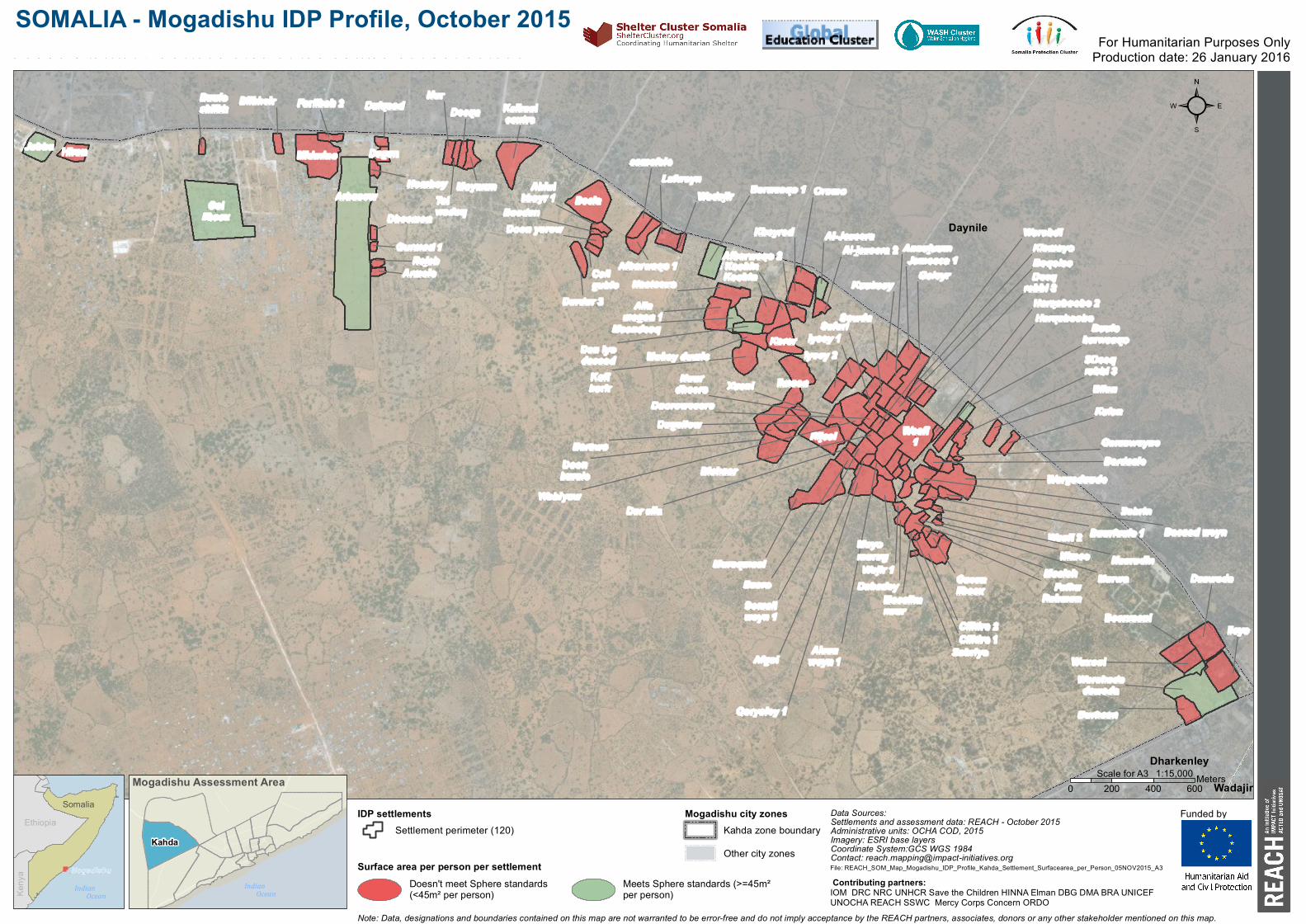
Armale
Beela
Bu u losh iikh
Dagan
Dh eeman
Du lqaad
Gu rmad 1
Hiran
Homboy
Ju bba
Kalkaalcentre
Rajab
Deeqa
Maymu n
Bilkh eir
Midmino
Farlibah 2
samafale
Du rdu r 3
LafweynWadajir Barwaaqo 1
Allamagan 1
Nasteexo
Dan iyodacaadKofih arir
Kh eyrad
Oromo
Al-jazeera 2
SowdaSafari
Dooroweeere
Boqolso
Waafi1
Galeyr Deeqrabbi 3
Annu ju u mJameeca 1
Somaliweyn 1
BasroMu raqmaal
Rijaal
Xu sni
BarawoDu gsilow
Doonbu rale
Sabrin
Alaaaweyn 1
Wajir 1
Waafi 2
BardaaleGarasweyne
SDeeqrabbi 3
Bu u lobarwaaqo
Bilan
Bu rh aan
ileys
Daawada
Beerxaani
Waxool
ArbacowGallibaax
iimaan
Kosh in
Korar
Nu u rdh eere
iyeey 2iyeey 1
Ku u kaay
Bu u rfu u le 1
Wargadu u do
Maslah
Ciiltire 2
Gacanlibaax
Ku lan
Warsh adadawada
Doon yarow
Wabiyow
Nu r
Talwadaq
Ah lu lkh ayr 1
Boodan
Caligu ble
Afbarwaqo 1
Maandeeq
Kosh inAfbarwaqo 2
Al-Jazeera
Mu kay du mis
MarwaFath uRah manMacalim
nu u r
Ciiltire 1Sabriye
Bacaad weyn
Nasru dinNimco
Dabadey
Afgoi
Qoryoley 1
Mayomu ru g
Kismayo
Harqaboobe 2Harqaboobe
Warabdi
Dar alla
Bish aar
Wadajir
Dharkenley
Daynile
Mogadish uIndian Ocean
Ethiopia
Keny
a
Somalia
²
0 200 400 600Meters
For Humanitarian Purposes OnlyProduction date: 26 January 2016
Note: Data, designations and boundaries contained on this map are not warranted to be error-free and do not imply acceptance by the REACH partners, associates, donors or any other stakeholder mentioned on this map.
Funded by
Indian Ocean
Kahda
SOMALIA - Mogadishu IDP Profile, October 2015Kah da District – Su rface area of th e settlement per person
Data Sources:Settlements and assessment data: REACH - October 2015Administrative units: OCHA COD, 2015Imagery: ESRI base layersCoordinate System:GCS WGS 1984Contact: [email protected]: REACH_SOM_Map_Mogadishu_IDP_Profile_Kahda_Settlement_Surfacearea_per_Person_05NOV2015_A3
Contributing partners: IOM DRC NRC UNHCR Save the Children HINNA Elman DBG DMA BRA UNICEF UNOCHA REACH SSWC Mercy Corps Concern ORDO
Mogadishu Assessment Area 1:15,000Scale for A3
Settlement perimeter (120)IDP settlements Mogadishu city zones
Kahda zone boundaryOther city zones
Surface area per person per settlementDoesn't meet Sphere standards(<45m² per person)
Meets Sphere standards (>=45m²per person)


![[MAG] October 2010](https://static.fdocuments.nl/doc/165x107/568bf2331a28ab893395cb5b/mag-october-2010.jpg)