The di Fernandina and Sierra Negra volcanoes (Galápagos ...
7
O V L O V NI O V REPORT O V L O V NI O V REPORT O V L O V NI O V REPORT The different characteristics of the recent eruptions of Fernandina and Sierra Negra volcanoes (Galápagos, Ecuador) Francisco Vasconez * α , Patricio Ramón α , Stephen Hernandez α , Silvana Hidalgo α , Benjamin Bernard α , Mario Ruiz α , Alexandra Alvarado α , Peter La Femina β , Gorki Ruiz γ α Instituto Geofísico, Escuela Politécnica Nacional. Quito, Ecuador. β The Pennsylvania State University. Pennsylvania, USA. γ Universidad Central del Ecuador. Quito, Ecuador. Abstract After eight years of quiescence, Fernandina volcano experienced two short-lived eruptions, on 4 September 2017 and 16 June 2018. The eruptions were characterized by very short periods of unrest that started a few hours before the initiation of the eruptive activity. On the other hand, Sierra Negra volcano (Isabela Island) began a new eruptive period on 26 June 2018, after almost one year of persistent unrest characterized by an increase in the magnitude and number of seismic events and more than 5 meters of uplift since its last eruption in 2005. The Sierra Negra and Fernandina eruptions were located in remote zones where access is extremely complex. Thus, satellite images complement the continuous monitoring data of the Instituto Geofísico (IG-EPN) with remote observations and allow rapid response mapping in order to identify the areas affected by the lava flows. Finally, the aim of this Report is to encourage other scientists to investigate the behaviors of both pre-eruptive and eruptive periods registered during these eruptions. Resumen Después de ocho años de reposo, el volcán Fernandina experimentó dos periodos eruptivos de corta duración, el 4 de Septiembre del 2017 y el 16 de Junio del 2018. Dichas erupciones se caracterizaron por etapas muy cortas de agitación que iniciaron pocas horas antes de la erupción. Por otro lado, el volcán Sierra Negra, localizado en la Isla Isabela, inició un nuevo periodo eruptivo el 26 de Junio del 2018, después de casi un año de persistente agitación caracterizada por el incremento en la magnitud y número de eventos sísmicos y más de cinco metros de levanta- miento del piso de la caldera desde su última erupción en 2005. Las erupciones de Sierra Negra y Fernandina se localizaron en zonas remotas, donde el acceso es extremadamente difícil. Es así que, imágenes satelitales comple- mentaron el monitoreo continuo realizado por el Instituto Geofísico (IG-EPN) y permitieron identificar las zonas afectadas por los flujos de lava. Finalmente, uno de los propósitos de este reporte es alentar a otros científicos a investigar el funcionamiento de estos volcanes durante las etapas pre-eruptivas y eruptivas registradas. Keywords: Galapagos; Sierra Negra; Fernandina; Remote sensing; Monitoring; Hazard Assessment 1 Introduction The Galapágos Islands are a group of basaltic shield volcanoes related to a hotspot that currently lies 170 km south of the Galápagos Spreading Center [Allan and Simkin 2000]. The western volcanoes located on Isabela and Fernandina islands show frequent activ- ity with approximately 69 eruptions reported since the early 1800s [Global Volcanism Program 2013c]. For in- stance, Fernandina volcano has had at least 28 histor- ical eruptions [Global Volcanism Program 2013a] in- cluding one in 2017 and 2018, and Sierra Negra had 13 [Global Volcanism Program 2013b] including one in 2018. Nonetheless, geophysical studies have been * Corresponding author: [email protected] limited due to the islands’ remote location [Rowland et al. 2003; Chadwick et al. 2011] and also because the only permanent human settlement in the area is the small town of Puerto Villamil at the south of Isabela. Thus, according to Rowland et al. 2003, p. 314 "many of the eruptions have gone unnoticed [...]. Although the human population has grown, access to eruption sites is still difficult". Only since the 1990s have eruptions been systematically observed and instrumentally mon- itored [e.g. Allan and Simkin 2000; Rowland et al. 2003; Chadwick et al. 2011; Geist et al. 2008; Bagnardi et al. 2013; Bernard et al. 2015; Xu et al. 2016]. In 2014, Instituto Geofísico (IG-EPN) installed new broadband seismometers on Fernandina (2) and Isabela (4), allowing a much better follow-up of the activity and for the first time allowing the study of seismic unrest
Transcript of The di Fernandina and Sierra Negra volcanoes (Galápagos ...
OV L
OV
NI
OV
REPORT OV L
OV
NI
OV
REPORT OV L
OV
NI
OV
REPORT
The different characteristics of the recent eruptions ofFernandina and Sierra Negra volcanoes (Galápagos, Ecuador)
Francisco Vasconez*α, Patricio Ramónα, Stephen Hernandezα, Silvana Hidalgoα,Benjamin Bernardα, Mario Ruizα, Alexandra Alvaradoα, Peter La Feminaβ , Gorki Ruizγ
αInstituto Geofísico, Escuela Politécnica Nacional. Quito, Ecuador.βThe Pennsylvania State University. Pennsylvania, USA.γUniversidad Central del Ecuador. Quito, Ecuador.
Abstract
After eight years of quiescence, Fernandina volcano experienced two short-lived eruptions, on 4 September 2017and 16 June 2018. The eruptions were characterized by very short periods of unrest that started a few hours beforethe initiation of the eruptive activity. On the other hand, Sierra Negra volcano (Isabela Island) began a new eruptiveperiod on 26 June 2018, after almost one year of persistent unrest characterized by an increase in the magnitudeand number of seismic events and more than 5 meters of uplift since its last eruption in 2005. The Sierra Negraand Fernandina eruptions were located in remote zones where access is extremely complex. Thus, satellite imagescomplement the continuous monitoring data of the Instituto Geofísico (IG-EPN) with remote observations and allowrapid response mapping in order to identify the areas affected by the lava flows. Finally, the aim of this Report is toencourage other scientists to investigate the behaviors of both pre-eruptive and eruptive periods registered duringthese eruptions.
Resumen
Después de ocho años de reposo, el volcán Fernandina experimentó dos periodos eruptivos de corta duración, el4 de Septiembre del 2017 y el 16 de Junio del 2018. Dichas erupciones se caracterizaron por etapas muy cortas deagitación que iniciaron pocas horas antes de la erupción. Por otro lado, el volcán Sierra Negra, localizado en la IslaIsabela, inició un nuevo periodo eruptivo el 26 de Junio del 2018, después de casi un año de persistente agitacióncaracterizada por el incremento en la magnitud y número de eventos sísmicos y más de cinco metros de levanta-miento del piso de la caldera desde su última erupción en 2005. Las erupciones de Sierra Negra y Fernandina selocalizaron en zonas remotas, donde el acceso es extremadamente difícil. Es así que, imágenes satelitales comple-mentaron el monitoreo continuo realizado por el Instituto Geofísico (IG-EPN) y permitieron identificar las zonasafectadas por los flujos de lava. Finalmente, uno de los propósitos de este reporte es alentar a otros científicos ainvestigar el funcionamiento de estos volcanes durante las etapas pre-eruptivas y eruptivas registradas.
Keywords: Galapagos; Sierra Negra; Fernandina; Remote sensing; Monitoring; Hazard Assessment
1 Introduction
The Galapágos Islands are a group of basaltic shieldvolcanoes related to a hotspot that currently lies 170km south of the Galápagos Spreading Center [Allanand Simkin 2000]. The western volcanoes located onIsabela and Fernandina islands show frequent activ-ity with approximately 69 eruptions reported since theearly 1800s [Global Volcanism Program 2013c]. For in-stance, Fernandina volcano has had at least 28 histor-ical eruptions [Global Volcanism Program 2013a] in-cluding one in 2017 and 2018, and Sierra Negra had13 [Global Volcanism Program 2013b] including onein 2018. Nonetheless, geophysical studies have been
*Corresponding author: [email protected]
limited due to the islands’ remote location [Rowland etal. 2003; Chadwick et al. 2011] and also because theonly permanent human settlement in the area is thesmall town of Puerto Villamil at the south of Isabela.Thus, according to Rowland et al. 2003, p. 314 "manyof the eruptions have gone unnoticed [...]. Although thehuman population has grown, access to eruption sitesis still difficult". Only since the 1990s have eruptionsbeen systematically observed and instrumentally mon-itored [e.g. Allan and Simkin 2000; Rowland et al. 2003;Chadwick et al. 2011; Geist et al. 2008; Bagnardi et al.2013; Bernard et al. 2015; Xu et al. 2016].
In 2014, Instituto Geofísico (IG-EPN) installed newbroadband seismometers on Fernandina (2) and Isabela(4), allowing a much better follow-up of the activity andfor the first time allowing the study of seismic unrest
The recent eruptions of Fernandina and Sierra Negra Vasconez et al., 2018
in detail. This Report presents an overview of the timeseries (seismic, ground deformation, SO2, thermal) be-fore and during recent eruptions in Galápagos (2017and 2018 Fernandina eruptions and 2018 Sierra Negra).This information allows us to illustrate significant dif-ferences between those volcanic systems and their be-havior.
2 Summary of the eruptions
The following summary is set in Coordinated UniversalTime (UTC) which for Galápagos Archipelago meansUTC-6 (local time).
2.1 Fernandina (Fernandina Island)
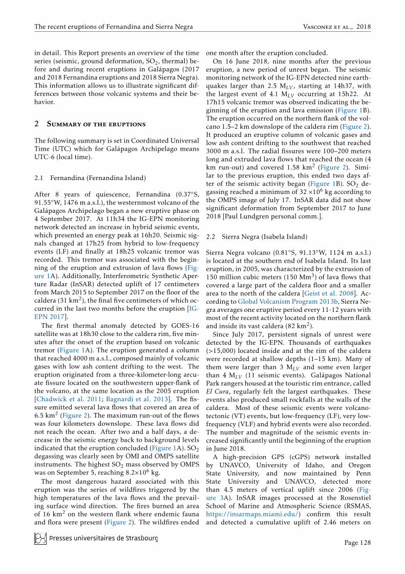
After 8 years of quiescence, Fernandina (0.37◦S,91.55◦W, 1476 m a.s.l.), the westernmost volcano of theGalápagos Archipelago began a new eruptive phase on4 September 2017. At 11h34 the IG-EPN monitoringnetwork detected an increase in hybrid seismic events,which presented an energy peak at 16h20. Seismic sig-nals changed at 17h25 from hybrid to low-frequencyevents (LF) and finally at 18h25 volcanic tremor wasrecorded. This tremor was associated with the begin-ning of the eruption and extrusion of lava flows (Fig-ure 1A). Additionally, Interferometric Synthetic Aper-ture Radar (InSAR) detected uplift of 17 centimetersfrom March 2015 to September 2017 on the floor of thecaldera (31 km2), the final five centimeters of which oc-curred in the last two months before the eruption [IG-EPN 2017].
The first thermal anomaly detected by GOES-16satellite was at 18h30 close to the caldera rim, five min-utes after the onset of the eruption based on volcanictremor (Figure 1A). The eruption generated a columnthat reached 4000 m a.s.l., composed mainly of volcanicgases with low ash content drifting to the west. Theeruption originated from a three-kilometer-long arcu-ate fissure located on the southwestern upper-flank ofthe volcano, at the same location as the 2005 eruption[Chadwick et al. 2011; Bagnardi et al. 2013]. The fis-sure emitted several lava flows that covered an area of6.5 km2 (Figure 2). The maximum run-out of the flowswas four kilometers downslope. These lava flows didnot reach the ocean. After two and a half days, a de-crease in the seismic energy back to background levelsindicated that the eruption concluded (Figure 1A). SO2degassing was clearly seen by OMI and OMPS satelliteinstruments. The highest SO2 mass observed by OMPSwas on September 5, reaching 8.2×10⁶ kg.
The most dangerous hazard associated with thiseruption was the series of wildfires triggered by thehigh temperatures of the lava flows and the prevail-ing surface wind direction. The fires burned an areaof 16 km2 on the western flank where endemic faunaand flora were present (Figure 2). The wildfires ended
one month after the eruption concluded.On 16 June 2018, nine months after the previous
eruption, a new period of unrest began. The seismicmonitoring network of the IG-EPN detected nine earth-quakes larger than 2.5 MLV , starting at 14h37, withthe largest event of 4.1 MLV occurring at 15h22. At17h15 volcanic tremor was observed indicating the be-ginning of the eruption and lava emission (Figure 1B).The eruption occurred on the northern flank of the vol-cano 1.5–2 km downslope of the caldera rim (Figure 2).It produced an eruptive column of volcanic gases andlow ash content drifting to the southwest that reached3000 m a.s.l. The radial fissures were 100–200 meterslong and extruded lava flows that reached the ocean (4km run-out) and covered 1.58 km2 (Figure 2). Simi-lar to the previous eruption, this ended two days af-ter of the seismic activity began (Figure 1B). SO2 de-gassing reached a minimum of 32 ×106 kg according tothe OMPS image of July 17. InSAR data did not showsignificant deformation from September 2017 to June2018 [Paul Lundgren personal comm.].
2.2 Sierra Negra (Isabela Island)
Sierra Negra volcano (0.81◦S, 91.13◦W, 1124 m a.s.l.)is located at the southern end of Isabela Island. Its lasteruption, in 2005, was characterized by the extrusion of150 million cubic meters (150 Mm3) of lava flows thatcovered a large part of the caldera floor and a smallerarea to the north of the caldera [Geist et al. 2008]. Ac-cording to Global Volcanism Program 2013b, Sierra Ne-gra averages one eruptive period every 11-12 years withmost of the recent activity located on the northern flankand inside its vast caldera (82 km2).
Since July 2017, persistent signals of unrest weredetected by the IG-EPN. Thousands of earthquakes(>15,000) located inside and at the rim of the calderawere recorded at shallow depths (1–15 km). Many ofthem were larger than 3 MLV and some even largerthan 4 MLV (11 seismic events). Galápagos NationalPark rangers housed at the touristic rim entrance, calledEl Cura, regularly felt the largest earthquakes. Theseevents also produced small rockfalls at the walls of thecaldera. Most of these seismic events were volcano-tectonic (VT) events, but low-frequency (LF), very low-frequency (VLF) and hybrid events were also recorded.The number and magnitude of the seismic events in-creased significantly until the beginning of the eruptionin June 2018.
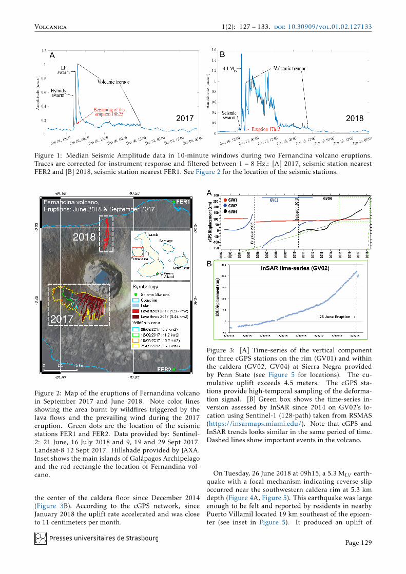
A high-precision GPS (cGPS) network installedby UNAVCO, University of Idaho, and OregonState University, and now maintained by PennState University and UNAVCO, detected morethan 4.5 meters of vertical uplift since 2006 (Fig-ure 3A). InSAR images processed at the RosenstielSchool of Marine and Atmospheric Science (RSMAS,https://insarmaps.miami.edu/) confirm this resultand detected a cumulative uplift of 2.46 meters on
Presses universitaires de �rasbourgPage 128
Volcanica 1(2): 127 – 133. doi: 10.30909/vol.01.02.127133
Figure 1: Median Seismic Amplitude data in 10-minute windows during two Fernandina volcano eruptions.Traces are corrected for instrument response and filtered between 1 – 8 Hz.: [A] 2017, seismic station nearestFER2 and [B] 2018, seismic station nearest FER1. See Figure 2 for the location of the seismic stations.
Figure 2: Map of the eruptions of Fernandina volcanoin September 2017 and June 2018. Note color linesshowing the area burnt by wildfires triggered by thelava flows and the prevailing wind during the 2017eruption. Green dots are the location of the seismicstations FER1 and FER2. Data provided by: Sentinel-2: 21 June, 16 July 2018 and 9, 19 and 29 Sept 2017.Landsat-8 12 Sept 2017. Hillshade provided by JAXA.Inset shows the main islands of Galápagos Archipelagoand the red rectangle the location of Fernandina vol-cano.
the center of the caldera floor since December 2014(Figure 3B). According to the cGPS network, sinceJanuary 2018 the uplift rate accelerated and was closeto 11 centimeters per month.
Figure 3: [A] Time-series of the vertical componentfor three cGPS stations on the rim (GV01) and withinthe caldera (GV02, GV04) at Sierra Negra providedby Penn State (see Figure 5 for locations). The cu-mulative uplift exceeds 4.5 meters. The cGPS sta-tions provide high-temporal sampling of the deforma-tion signal. [B] Green box shows the time-series in-version assessed by InSAR since 2014 on GV02’s lo-cation using Sentinel-1 (128-path) taken from RSMAS(https://insarmaps.miami.edu/). Note that cGPS andInSAR trends looks similar in the same period of time.Dashed lines show important events in the volcano.
On Tuesday, 26 June 2018 at 09h15, a 5.3 MLV earth-quake with a focal mechanism indicating reverse slipoccurred near the southwestern caldera rim at 5.3 kmdepth (Figure 4A, Figure 5). This earthquake was largeenough to be felt and reported by residents in nearbyPuerto Villamil located 19 km southeast of the epicen-ter (see inset in Figure 5). It produced an uplift of
Presses universitaires de �rasbourgPage 129
The recent eruptions of Fernandina and Sierra Negra Vasconez et al., 2018
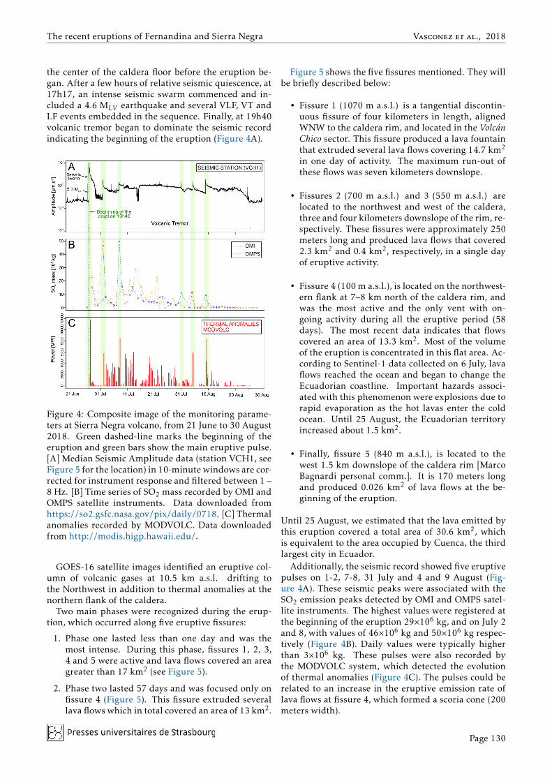
the center of the caldera floor before the eruption be-gan. After a few hours of relative seismic quiescence, at17h17, an intense seismic swarm commenced and in-cluded a 4.6 MLV earthquake and several VLF, VT andLF events embedded in the sequence. Finally, at 19h40volcanic tremor began to dominate the seismic recordindicating the beginning of the eruption (Figure 4A).
Figure 4: Composite image of the monitoring parame-ters at Sierra Negra volcano, from 21 June to 30 August2018. Green dashed-line marks the beginning of theeruption and green bars show the main eruptive pulse.[A] Median Seismic Amplitude data (station VCH1, seeFigure 5 for the location) in 10-minute windows are cor-rected for instrument response and filtered between 1 –8 Hz. [B] Time series of SO2 mass recorded by OMI andOMPS satellite instruments. Data downloaded fromhttps://so2.gsfc.nasa.gov/pix/daily/0718. [C] Thermalanomalies recorded by MODVOLC. Data downloadedfrom http://modis.higp.hawaii.edu/.
GOES-16 satellite images identified an eruptive col-umn of volcanic gases at 10.5 km a.s.l. drifting tothe Northwest in addition to thermal anomalies at thenorthern flank of the caldera.
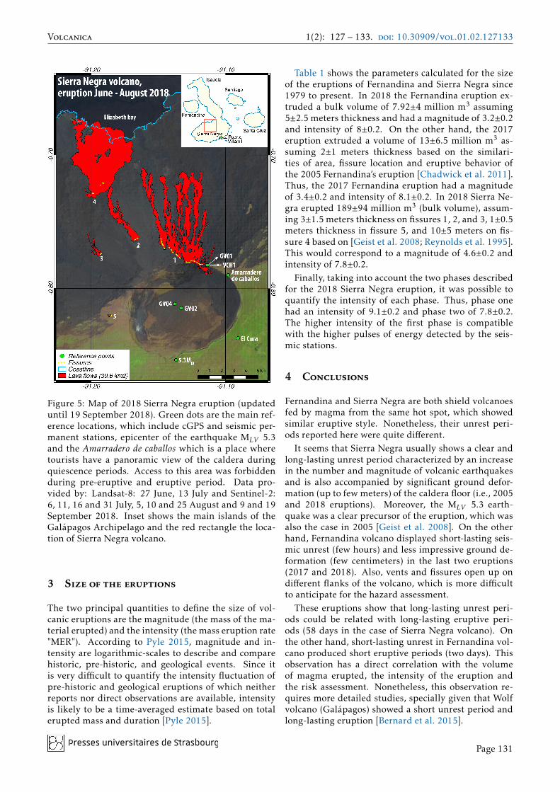
Two main phases were recognized during the erup-tion, which occurred along five eruptive fissures:
1. Phase one lasted less than one day and was themost intense. During this phase, fissures 1, 2, 3,4 and 5 were active and lava flows covered an areagreater than 17 km2 (see Figure 5).
2. Phase two lasted 57 days and was focused only onfissure 4 (Figure 5). This fissure extruded severallava flows which in total covered an area of 13 km2.
Figure 5 shows the five fissures mentioned. They willbe briefly described below:
• Fissure 1 (1070 m a.s.l.) is a tangential discontin-uous fissure of four kilometers in length, alignedWNW to the caldera rim, and located in the VolcánChico sector. This fissure produced a lava fountainthat extruded several lava flows covering 14.7 km2
in one day of activity. The maximum run-out ofthese flows was seven kilometers downslope.
• Fissures 2 (700 m a.s.l.) and 3 (550 m a.s.l.) arelocated to the northwest and west of the caldera,three and four kilometers downslope of the rim, re-spectively. These fissures were approximately 250meters long and produced lava flows that covered2.3 km2 and 0.4 km2, respectively, in a single dayof eruptive activity.
• Fissure 4 (100 m a.s.l.), is located on the northwest-ern flank at 7–8 km north of the caldera rim, andwas the most active and the only vent with on-going activity during all the eruptive period (58days). The most recent data indicates that flowscovered an area of 13.3 km2. Most of the volumeof the eruption is concentrated in this flat area. Ac-cording to Sentinel-1 data collected on 6 July, lavaflows reached the ocean and began to change theEcuadorian coastline. Important hazards associ-ated with this phenomenon were explosions due torapid evaporation as the hot lavas enter the coldocean. Until 25 August, the Ecuadorian territoryincreased about 1.5 km2.
• Finally, fissure 5 (840 m a.s.l.), is located to thewest 1.5 km downslope of the caldera rim [MarcoBagnardi personal comm.]. It is 170 meters longand produced 0.026 km2 of lava flows at the be-ginning of the eruption.
Until 25 August, we estimated that the lava emitted bythis eruption covered a total area of 30.6 km2, whichis equivalent to the area occupied by Cuenca, the thirdlargest city in Ecuador.
Additionally, the seismic record showed five eruptivepulses on 1-2, 7-8, 31 July and 4 and 9 August (Fig-ure 4A). These seismic peaks were associated with theSO2 emission peaks detected by OMI and OMPS satel-lite instruments. The highest values were registered atthe beginning of the eruption 29×106 kg, and on July 2and 8, with values of 46×106 kg and 50×106 kg respec-tively (Figure 4B). Daily values were typically higherthan 3×10⁶ kg. These pulses were also recorded bythe MODVOLC system, which detected the evolutionof thermal anomalies (Figure 4C). The pulses could berelated to an increase in the eruptive emission rate oflava flows at fissure 4, which formed a scoria cone (200meters width).
Presses universitaires de �rasbourgPage 130
Volcanica 1(2): 127 – 133. doi: 10.30909/vol.01.02.127133
Figure 5: Map of 2018 Sierra Negra eruption (updateduntil 19 September 2018). Green dots are the main ref-erence locations, which include cGPS and seismic per-manent stations, epicenter of the earthquake MLV 5.3and the Amarradero de caballos which is a place wheretourists have a panoramic view of the caldera duringquiescence periods. Access to this area was forbiddenduring pre-eruptive and eruptive period. Data pro-vided by: Landsat-8: 27 June, 13 July and Sentinel-2:6, 11, 16 and 31 July, 5, 10 and 25 August and 9 and 19September 2018. Inset shows the main islands of theGalápagos Archipelago and the red rectangle the loca-tion of Sierra Negra volcano.
3 Size of the eruptions
The two principal quantities to define the size of vol-canic eruptions are the magnitude (the mass of the ma-terial erupted) and the intensity (the mass eruption rate"MER"). According to Pyle 2015, magnitude and in-tensity are logarithmic-scales to describe and comparehistoric, pre-historic, and geological events. Since itis very difficult to quantify the intensity fluctuation ofpre-historic and geological eruptions of which neitherreports nor direct observations are available, intensityis likely to be a time-averaged estimate based on totalerupted mass and duration [Pyle 2015].
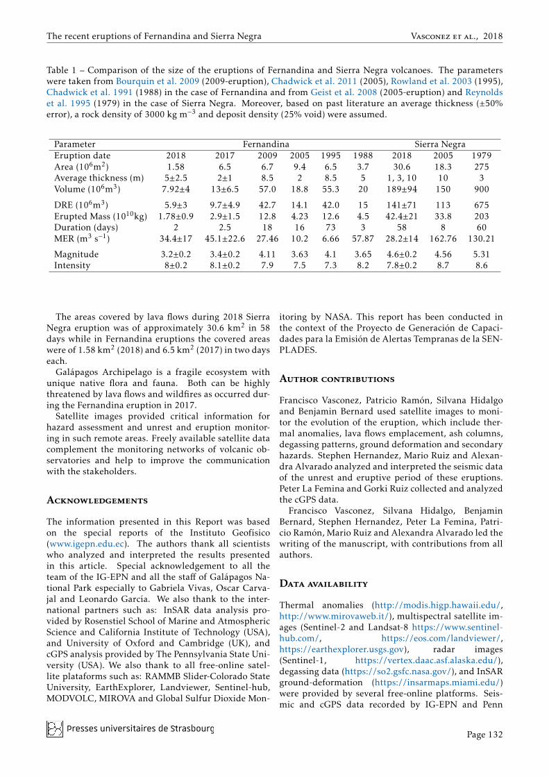
Table 1 shows the parameters calculated for the sizeof the eruptions of Fernandina and Sierra Negra since1979 to present. In 2018 the Fernandina eruption ex-truded a bulk volume of 7.92±4 million m3 assuming5±2.5 meters thickness and had a magnitude of 3.2±0.2and intensity of 8±0.2. On the other hand, the 2017eruption extruded a volume of 13±6.5 million m3 as-suming 2±1 meters thickness based on the similari-ties of area, fissure location and eruptive behavior ofthe 2005 Fernandina’s eruption [Chadwick et al. 2011].Thus, the 2017 Fernandina eruption had a magnitudeof 3.4±0.2 and intensity of 8.1±0.2. In 2018 Sierra Ne-gra erupted 189±94 million m3 (bulk volume), assum-ing 3±1.5 meters thickness on fissures 1, 2, and 3, 1±0.5meters thickness in fissure 5, and 10±5 meters on fis-sure 4 based on [Geist et al. 2008; Reynolds et al. 1995].This would correspond to a magnitude of 4.6±0.2 andintensity of 7.8±0.2.
Finally, taking into account the two phases describedfor the 2018 Sierra Negra eruption, it was possible toquantify the intensity of each phase. Thus, phase onehad an intensity of 9.1±0.2 and phase two of 7.8±0.2.The higher intensity of the first phase is compatiblewith the higher pulses of energy detected by the seis-mic stations.
4 Conclusions
Fernandina and Sierra Negra are both shield volcanoesfed by magma from the same hot spot, which showedsimilar eruptive style. Nonetheless, their unrest peri-ods reported here were quite different.
It seems that Sierra Negra usually shows a clear andlong-lasting unrest period characterized by an increasein the number and magnitude of volcanic earthquakesand is also accompanied by significant ground defor-mation (up to few meters) of the caldera floor (i.e., 2005and 2018 eruptions). Moreover, the MLV 5.3 earth-quake was a clear precursor of the eruption, which wasalso the case in 2005 [Geist et al. 2008]. On the otherhand, Fernandina volcano displayed short-lasting seis-mic unrest (few hours) and less impressive ground de-formation (few centimeters) in the last two eruptions(2017 and 2018). Also, vents and fissures open up ondifferent flanks of the volcano, which is more difficultto anticipate for the hazard assessment.
These eruptions show that long-lasting unrest peri-ods could be related with long-lasting eruptive peri-ods (58 days in the case of Sierra Negra volcano). Onthe other hand, short-lasting unrest in Fernandina vol-cano produced short eruptive periods (two days). Thisobservation has a direct correlation with the volumeof magma erupted, the intensity of the eruption andthe risk assessment. Nonetheless, this observation re-quires more detailed studies, specially given that Wolfvolcano (Galápagos) showed a short unrest period andlong-lasting eruption [Bernard et al. 2015].
Presses universitaires de �rasbourgPage 131
The recent eruptions of Fernandina and Sierra Negra Vasconez et al., 2018
Table 1 – Comparison of the size of the eruptions of Fernandina and Sierra Negra volcanoes. The parameterswere taken from Bourquin et al. 2009 (2009-eruption), Chadwick et al. 2011 (2005), Rowland et al. 2003 (1995),Chadwick et al. 1991 (1988) in the case of Fernandina and from Geist et al. 2008 (2005-eruption) and Reynoldset al. 1995 (1979) in the case of Sierra Negra. Moreover, based on past literature an average thickness (±50%error), a rock density of 3000 kg m−3 and deposit density (25% void) were assumed.
Parameter Fernandina Sierra NegraEruption date 2018 2017 2009 2005 1995 1988 2018 2005 1979Area (106m2) 1.58 6.5 6.7 9.4 6.5 3.7 30.6 18.3 275Average thickness (m) 5±2.5 2±1 8.5 2 8.5 5 1, 3, 10 10 3Volume (106m3) 7.92±4 13±6.5 57.0 18.8 55.3 20 189±94 150 900
DRE (106m3) 5.9±3 9.7±4.9 42.7 14.1 42.0 15 141±71 113 675Erupted Mass (1010kg) 1.78±0.9 2.9±1.5 12.8 4.23 12.6 4.5 42.4±21 33.8 203Duration (days) 2 2.5 18 16 73 3 58 8 60MER (m3 s−1) 34.4±17 45.1±22.6 27.46 10.2 6.66 57.87 28.2±14 162.76 130.21
Magnitude 3.2±0.2 3.4±0.2 4.11 3.63 4.1 3.65 4.6±0.2 4.56 5.31Intensity 8±0.2 8.1±0.2 7.9 7.5 7.3 8.2 7.8±0.2 8.7 8.6
The areas covered by lava flows during 2018 SierraNegra eruption was of approximately 30.6 km2 in 58days while in Fernandina eruptions the covered areaswere of 1.58 km2 (2018) and 6.5 km2 (2017) in two dayseach.
Galápagos Archipelago is a fragile ecosystem withunique native flora and fauna. Both can be highlythreatened by lava flows and wildfires as occurred dur-ing the Fernandina eruption in 2017.
Satellite images provided critical information forhazard assessment and unrest and eruption monitor-ing in such remote areas. Freely available satellite datacomplement the monitoring networks of volcanic ob-servatories and help to improve the communicationwith the stakeholders.
Acknowledgements
The information presented in this Report was basedon the special reports of the Instituto Geofísico(www.igepn.edu.ec). The authors thank all scientistswho analyzed and interpreted the results presentedin this article. Special acknowledgement to all theteam of the IG-EPN and all the staff of Galápagos Na-tional Park especially to Gabriela Vivas, Oscar Carva-jal and Leonardo García. We also thank to the inter-national partners such as: InSAR data analysis pro-vided by Rosenstiel School of Marine and AtmosphericScience and California Institute of Technology (USA),and University of Oxford and Cambridge (UK), andcGPS analysis provided by The Pennsylvania State Uni-versity (USA). We also thank to all free-online satel-lite plataforms such as: RAMMB Slider-Colorado StateUniversity, EarthExplorer, Landviewer, Sentinel-hub,MODVOLC, MIROVA and Global Sulfur Dioxide Mon-
itoring by NASA. This report has been conducted inthe context of the Proyecto de Generación de Capaci-dades para la Emisión de Alertas Tempranas de la SEN-PLADES.
Author contributions
Francisco Vasconez, Patricio Ramón, Silvana Hidalgoand Benjamin Bernard used satellite images to moni-tor the evolution of the eruption, which include ther-mal anomalies, lava flows emplacement, ash columns,degassing patterns, ground deformation and secondaryhazards. Stephen Hernandez, Mario Ruiz and Alexan-dra Alvarado analyzed and interpreted the seismic dataof the unrest and eruptive period of these eruptions.Peter La Femina and Gorki Ruiz collected and analyzedthe cGPS data.
Francisco Vasconez, Silvana Hidalgo, BenjaminBernard, Stephen Hernandez, Peter La Femina, Patri-cio Ramón, Mario Ruiz and Alexandra Alvarado led thewriting of the manuscript, with contributions from allauthors.
Data availability
Thermal anomalies (http://modis.higp.hawaii.edu/,http://www.mirovaweb.it/), multispectral satellite im-ages (Sentinel-2 and Landsat-8 https://www.sentinel-hub.com/, https://eos.com/landviewer/,https://earthexplorer.usgs.gov), radar images(Sentinel-1, https://vertex.daac.asf.alaska.edu/),degassing data (https://so2.gsfc.nasa.gov/), and InSARground-deformation (https://insarmaps.miami.edu/)were provided by several free-online platforms. Seis-mic and cGPS data recorded by IG-EPN and Penn
Presses universitaires de �rasbourgPage 132
Volcanica 1(2): 127 – 133. doi: 10.30909/vol.01.02.127133
University and UNAVCO can be requested for furtheranalysis and future work at https://www.igepn.edu.ec/and http://www.unavco.org/ respectively.
Copyright notice
© The Author(s) 2018. This article is distributed un-der the terms of the Creative Commons Attribution 4.0International License, which permits unrestricted use,distribution, and reproduction in any medium, pro-vided you give appropriate credit to the original au-thor(s) and the source, provide a link to the CreativeCommons license, and indicate if changes were made.
References
Allan, J. F. and T. Simkin (2000). “Fernandina Vol-cano’s evolved, well-mixed basalts: Mineralogicaland petrological constraints on the nature of theGalapagos plume”. Journal of Geophysical Research:Solid Earth 105.B3, pp. 6017–6041. doi: 10.1029/1999jb900417.
Bagnardi, M., F. Amelung, and M. P. Poland (2013). “Anew model for the growth of basaltic shields basedon deformation of Fernandina volcano, Galápagos Is-lands”. Earth and Planetary Science Letters 377-378,pp. 358–366. doi: 10.1016/j.epsl.2013.07.016.
Bernard, B., H. Wright, P. Ramon, A. Guevara, S. Hi-dalgo, D. Pacheco, D. Narváez, and F. Vásconez(2015). “Preliminary Results on the 2015 Eruptionof Wolf Volcano, Isabela Island, Galápagos: Chronol-ogy, Dispersion of the Volcanic Products, and Insightinto the Eruptive Dynamics”. AGU Fall Meeting Ab-stracts. V31B-3022.
Bourquin, J., S. Hidalgo, B. Bernard, P. Ramón, S.Vallejo, and A. Parmigiani (2009). Fernandina volcanoeruption, Galápagos Islands, Ecuador: SO2 and thermalfield measurements compared with satellite data: Infor-mal report, Instituto Geofísico Escuela Politécnica Na-cional (IGEPN).
Chadwick, W. W., S. Jónsson, D. J. Geist, M. Poland,D. J. Johnson, S. Batt, K. S. Harpp, and A. Ruiz(2011). “The May 2005 eruption of Fernandina vol-cano, Galápagos: The first circumferential dike intru-sion observed by GPS and InSAR”. Bulletin of Vol-canology 73.6, pp. 679–697. doi: 10.1007/s00445-010-0433-0.
Chadwick, W. W., T. D. Roy, and A. Carrasco (1991).“The September 1988 intracaldera avalanche anderuption at Fernandina volcano, Galapagos Islands”.Bulletin of Volcanology 53.4, pp. 276–286. doi: 10.1007/bf00414524.
IG-EPN (2017). Informe Especial del Volcán FernandinaN◦02.
Geist, D. J., K. S. Harpp, T. R. Naumann, M. Poland,W. W. Chadwick, M. Hall, and E. Rader (2008). “The2005 eruption of Sierra Negra volcano, Galápagos,Ecuador”. Bulletin of Volcanology 70.6, pp. 655–673.doi: 10.1007/s00445-007-0160-3.
Global Volcanism Program (2013a). [Fernandina(353010)] in Volcanoes of the World, v. 4.7.1. Ven-zke, E (ed.). Smithsonian Institution. url: https://volcano.si.edu/volcano.cfm?vn=353010 (visitedon 10/02/2018).
– (2013b). [Sierra Negra (353050)] in Volcanoes of theWorld, v. 4.7.1. Venzke, E (ed.). Smithsonian Institution.url: https://volcano.si.edu/volcano.cfm?vn=353050 (visited on 08/06/2018).
– (2013c). Volcanoes of the World, v. 4.7.1. Venzke,E (ed.). Smithsonian Institution. url: https : / /
volcano.si.edu (visited on 10/02/2018).Pyle, D. M. (2015). “Sizes of volcanic eruptions”. The
Encyclopedia of Volcanoes. Ed. by H. Sigurdsson, B.Houghton, S. McNutt, H. Rymer, and J. Stix. Elsevier,pp. 257–264.
Reynolds, R. W., D. Geist, and M. D. Kurz (1995).“Physical volcanology and structural developmentof Sierra Negra volcano, Isabela Island, Galápagosarchipelago”. Geological Society of America Bulletin107.12, pp. 1398–1410. doi: 10 . 1130 / 0016 -
7606(1995)107<1398:pvasdo>2.3.co;2.Rowland, S. K., A. J. L. Harris, M. J. Wooster, F.
Amelung, H. Garbeil, L. Wilson, and P. J. Mouginis-Mark (2003). “Volumetric characteristics of lavaflows from interferometric radar and multispectralsatellite data: the 1995 Fernandina and 1998 CerroAzul eruptions in the western Galapagos”. Bulletinof Volcanology 65.5, pp. 311–330. doi: 10 . 1007 /s00445-002-0262-x.
Xu, W., S. Jónsson, J. Ruch, and Y. Aoki (2016). “The2015 Wolf volcano (Galápagos) eruption studied us-ing Sentinel-1 and ALOS-2 data”. Geophysical Re-search Letters 43.18, pp. 9573–9580. doi: 10.1002/2016gl069820.
Presses universitaires de �rasbourgPage 133