Sh o relin M ast P g m - fortress.wa.gov · MYR EBO ST 1 S T V E N S U N S E TS N E V IK NG CREST...
6
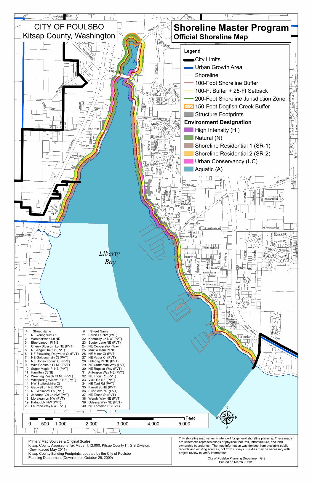
NW BOVELA LN (PVT) VIKING AVE NW NW BAY ST 19 18 20 17 21 22 5TH AVE NW 3RD AVE NW NW LIBERTY RD LN NW NILSEN NILSEN LN NW NW BRITE STAR LN NW ANDERSON LN NW CEDAR LN WINTON LN NW NW EDVARD ST STATE H NW RASMUSSEN CT NW TERRACE DR NW CAROLYN LN NW FINN HILL RD NW LINDVIG WAY BOND RD NE NE BERNT RD NE BERNT RD 1ST AVE NE NE BONDWOOD DR (PVT) NE GENE'S LN (PVT) FRONT ST NE NE HART CT TORVAL NE CANYON RD 2ND AVE NE LYSIR CT NE REIGN CT NE WODEN CT NE 11 12 13 10 9 8 7 6 5 4 16 15 23 23 NE ARBUTUS CT CREAT LP NE ASH JENSEN WAY NE NE UNION ST 2ND AVE NE NE MYREBOE ST 1ST AVE NE SUNSET ST NE N N HOVED RD NE BUR RUND LP NE PL NE MOSJON CIR NE ST 40 NE LINCOLN RD POWDER 8TH AVE NE NE IVERSON ST MOE ST JENSEN WAY NE BJERMELAND PL NE 3RD AVE NE BURNS PL NE NE VIEWMONT PL 5TH AVE NE NE LINCOLN RD 4TH AVE NE 31 ANDERSON PKWY FRONT ST NE NE ELIASON ST NESS PL NE NE HOSTMARK ST NE HOSTMARK ST 10TH AVE NE 11TH AVE NE 12TH AVE NE NE GILMAX LN FJORD DR NE NELSON PL NE 6TH AVE NE NE RYEN ST NE HARRISON ST 8TH AVE NE 9TH AVE NE NE SOMMERSETH ST NE HAUGEN ST TORGESON AVE NE NE MATSON ST NE TOLLEFSON ST NE SHOREWOOD CT 9TH AVE NE FJORD DR NE NE HOLM CT ENDEN PL NE NE NORDNESS ST THOMPSON PL NE STATE HIGHWAY 305 FISK CT NE 10TH AVE NE 11TH AVE NE NE SWANSON WAY RINDAL CT NE 10TH AVE NE NE SOL VEI 10TH PL NE BAYWATCH CT NE 13TH AVE NE NE ROGALAND CT NE RIGG CT NE ODIN CT SKOG CT NE 13TH AVE NE NE ODIN ST HAVN CT NE 15TH LP NE 15TH LP NE NE ODIN Liberty Bay CITY OF POULSBO Kitsap County, Washington Legend City Limits Urban Growth Area Shoreline 100-Foot Shoreline Buffer 100-Ft Buffer + 25-Ft Setback 200-Foot Shoreline Jurisdiction Zone 150-Foot Dogfish Creek Buffer Structure Footprints Environment Designation High Intensity (HI) Natural (N) Shoreline Residential 1 (SR-1) Shoreline Residential 2 (SR-2) Urban Conservancy (UC) Aquatic (A) Shoreline Master Program Official Shoreline Map City of Poulsbo Planning Department GIS Printed on March 9, 2012 This shoreline map series is intended for general shoreline planning. These maps are schematic representations of physical features, infrastructure, and land ownership boundaries. The map information was derived from available public records and existing sources, not from surveys. Studies may be necessary with project review to verify information. Primary Map Sources & Original Scales: Kitsap County Assessor's Tax Maps 1:12,000, Kitsap County IT, GIS Division. (Downloaded May 2011) Kitsap County Building Footprints, updated by the City of Poulsbo Planning Department (Downloaded October 26, 2009) 0 1,000 2,000 3,000 4,000 5,000 500 Feet # Street Name 1 NE Youngquist St 2 Weathervane Ln NE 3 Blue Lagoon Pl NE 4 Cherry Blossom Lp NE (PVT) 5 NE Angel Oak Ct (PVT) 6 NE Flowering Dogwood Ct (PVT) 7 NE Goldenchain Ct (PVT) 8 NE Honey Locust Ct (PVT) 9 Wild Chestnut Pl NE (PVT) 10 Sugar Maple Pl NE (PVT) 11 Hamilton Ct NE 12 Weeping Peach Ct NE (PVT) 13 Whispering Willow Pl NE (PVT) 14 NW Staffordshire Ct 15 Gadwell Ln NE (PVT) 16 NE Whimbrel Ln (PVT) 17 Johanna Vel Ln NW (PVT) 18 Morajean Ln NW (PVT) 19 Patriot LN NW (PVT) 20 Laurene Way NW (PVT) # Street Name 21 Baron Ln NW (PVT) 22 Kentucky Ln NW (PVT) 23 Scoter Lane NE (PVT) 24 NE Cooperation Way 25 Max William Pl NE 26 NE Minor Ct (PVT) 27 NE Vader Ct (PVT) 28 Hillsong Pl NE (PVT) 29 NE Craftsman Way (PVT) 30 NE Rugosa Way (PVT) 31 Antonson Way NE (PVT) 32 NE Tricia Rd (PVT) 33 Vicki Rd NE (PVT) 34 NE Tani Rd (PVT) 35 Farreil St NE (PVT) 36 Elliott Ave NE (PVT) 37 NE Tosha St (PVT) 38 Wendy Way NE (PVT) 39 Odessa Way NE (PVT) 40 NE Fontaine St (PVT)
Transcript of Sh o relin M ast P g m - fortress.wa.gov · MYR EBO ST 1 S T V E N S U N S E TS N E V IK NG CREST...
NW BOVELA LN (PVT)
VIKING
AVE N
W
NW BAY ST
1918
20
17
21 22
5TH A
VE NW
3RD A
VE NW
NW LIBERTY RD
LN NW
NILSEN
NILSE
N LN
NW
NW BRITE STARLN
NWANDERSONLN
NW CEDA
R LN
WINT
ON
LN NW
NW EDVARD ST
STATE HIGHWAY 3
NW KARKAINEN
NW RASMUSSEN CT
14
STAFFORDSHIRELN NW
GURLEY CTNW
TERRA
CE DR NW
NWCAROLYN LN
NW FINN HILL RD
NWLINDVIG WAY
BOND RD NE
NE BERNT RD
NE BERNT RD
1ST A
VE NE
NE BONDWOODDR (PVT)
LITTL
E VAL
LEY R
D NE
NE GENE'S LN (PVT)LN (PVT)
FRONT ST NE NEHARTCT
TORVALNE CANYON
RD
2ND A
VE NE
LYSIR
CT NE
REIGN
CT NE
WODEN CT NE
11 12 13
10
98765
4
1615
23
23
NE ARBUTUS
CT
4TH A
VE NE
CREAT
LP NE
ASH
JENSEN
WAYNE
NE UNION ST
2ND A
VE NE
NEMYREBOEST
1ST A
VE NE
SUNSET STNE
VIKINGCREST RD (PVT)
7TH A
VE NE
STAT
E HIGH
WAY 3
05
NELIBERTY RD 10T
H AVE
NE
NE LE
NA PL
12TH
AVE N
E
NENORDIC
HOVE
D
RD
NE
BUR R
UND
LP NE
NE FOREST ROCK LN
STAV
ANGE
RPL
NEST
AVAN
GER
LP NE MO
SJON
CIR NE
AMBERCT NE
CAMEOCT NE
TURQUOISE
CT NE
12TH A
VE NE
GARN
ET CT NE
NE WATLAND ST
ROSEBUD PL NE
3940
NE LINCOLN RD
POWDE
RHIL
LPL NE
(PVT)
8TH A
VE NENE
IVERSON ST
MOE ST
JENS
EN W
AY NE
BJER
MELA
NDPL
NE3R
D AVE
NEBU
RNS P
L NE
NEVIEWMONTPL
5TH
AV
E NE
NE LINCOLN RD
4TH A
VE NE
31
ANDERSON PKWY
FRONT ST NE
NE ELIASON STNESS
PL NE
NE HOSTMARK ST NE HOSTMARK ST
10TH A
VE NE
11TH A
VE NE
12TH A
VE NE
NE GILMAX LN
FJORD
DR NE
NELS
ON PL
NE
6TH A
VE NE
NE RYEN ST
NE HARRISON ST
8TH A
VE NE
9TH A
VE NE
NE SOMMERSETHST
NE HAUGEN ST
TORGESONAVE NE
NE MATSON ST NETOLLEFSONST
NESHOREWOOD
CT
9TH A
VE NE
FJORD DR NENE HOLM CT
ENDE
NPL
NE
NENORDNESSST
THOM
PSON
PL NE
STATE HIGHWAY 305
FISK
CT NE
10TH A
VE NE
11TH A
VE NE
NESWANSON WAY
RINDA
LCT
NE
10TH A
VE NE
NE SOL VEI
10THPL NE
BAYW
ATCH
CT N
E
13TH A
VE NE
NEROGALAND CT
NE RIGG CT
NE ODIN CT
SKOGCT NE
13TH A
VENE
NE ODIN ST
HAVN
CT NE
15TH L
P NE
15TH L
P NE
NEODIN ST
Liberty Bay
CITY OF POULSBOKitsap County, Washington
LegendCity LimitsUrban Growth AreaShoreline100-Foot Shoreline Buffer100-Ft Buffer + 25-Ft Setback200-Foot Shoreline Jurisdiction Zone150-Foot Dogfish Creek BufferStructure Footprints
Environment DesignationHigh Intensity (HI)Natural (N)Shoreline Residential 1 (SR-1)Shoreline Residential 2 (SR-2)Urban Conservancy (UC)Aquatic (A)
Shoreline Master ProgramOfficial Shoreline Map
City of Poulsbo Planning Department GISPrinted on March 9, 2012
This shoreline map series is intended for general shoreline planning. These maps are schematic representations of physical features, infrastructure, and land ownership boundaries. The map information was derived from available public records and existing sources, not from surveys. Studies may be necessary with project review to verify information.
Primary Map Sources & Original Scales:Kitsap County Assessor's Tax Maps 1:12,000, Kitsap County IT, GIS Division.(Downloaded May 2011)Kitsap County Building Footprints, updated by the City of Poulsbo Planning Department (Downloaded October 26, 2009)
0 1,000 2,000 3,000 4,000 5,000500Feet
# Street Name1 NE Youngquist St2 Weathervane Ln NE3 Blue Lagoon Pl NE4 Cherry Blossom Lp NE (PVT)5 NE Angel Oak Ct (PVT)6 NE Flowering Dogwood Ct (PVT)7 NE Goldenchain Ct (PVT)8 NE Honey Locust Ct (PVT)9 Wild Chestnut Pl NE (PVT)10 Sugar Maple Pl NE (PVT)11 Hamilton Ct NE12 Weeping Peach Ct NE (PVT)13 Whispering Willow Pl NE (PVT)14 NW Staffordshire Ct 15 Gadwell Ln NE (PVT)16 NE Whimbrel Ln (PVT)17 Johanna Vel Ln NW (PVT)18 Morajean Ln NW (PVT)19 Patriot LN NW (PVT)20 Laurene Way NW (PVT)
# Street Name21 Baron Ln NW (PVT)22 Kentucky Ln NW (PVT)23 Scoter Lane NE (PVT)24 NE Cooperation Way25 Max William Pl NE26 NE Minor Ct (PVT)27 NE Vader Ct (PVT)28 Hillsong Pl NE (PVT)29 NE Craftsman Way (PVT)30 NE Rugosa Way (PVT)31 Antonson Way NE (PVT)32 NE Tricia Rd (PVT)33 Vicki Rd NE (PVT)34 NE Tani Rd (PVT)35 Farreil St NE (PVT)36 Elliott Ave NE (PVT)37 NE Tosha St (PVT)38 Wendy Way NE (PVT)39 Odessa Way NE (PVT)40 NE Fontaine St (PVT)
NE L INCOLN RD
4TH A
VE NE
31
FRONT ST NE
N E ELIA SO N STNESS
PL NE
N E H O S TM A R K S T N E H O S TM A R K S T
FJORD
DR NE
NELS
ON PL
NE
6TH A
VE NE
N E RY E N S T
N E H A R R IS O N S T
8TH A
VE NE
9TH A
VE NE
N E SO M M E R S ET HST
N E H A U G E N ST
TORGESONAVE NE
N E M ATS O N ST N ETO LLEF S O NST
NESHO REW OOD
CT
9TH A
VE NE
FJO RD DR N EN E H O LM C T
ENDE
NPL
NEN EN O R D N E SSST
THOM
PSON
PL NE
STATE H IGHW AY 305
FIS K
CT N E
10TH A
VE NE
11TH A
VE NE
N ESW A N S O N W AY
RINDA
LCT
NE
10TH A
VE NE
NE SOL VE I
10THPL NE
BAYW
ATCH
13TH A
VE NE
NE O D IN CT
SKOGCT NE
13TH A
VENE
Liberty Bay
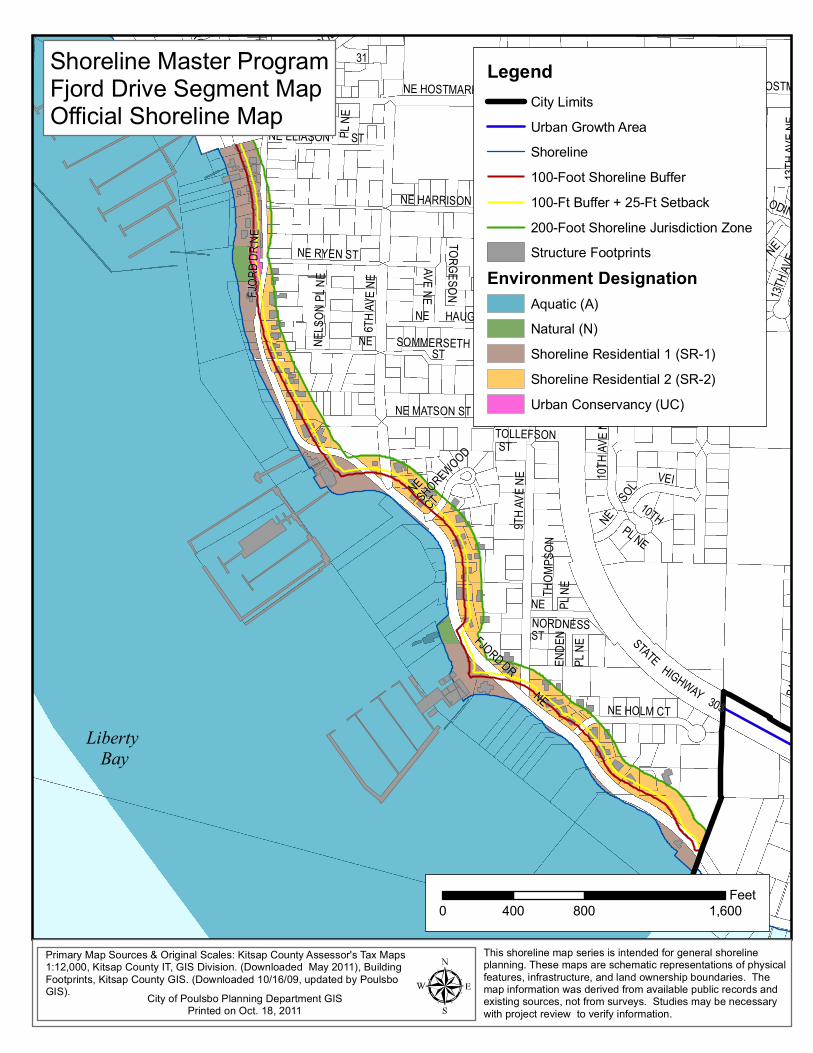
Shoreline M aster P rogramFjord D rive Segm ent M apO fficia l Shoreline M ap
This shore line m ap se ries is in tended for gene ral sho reline plann ing. These m aps a re schem atic rep resen ta tions o f physica lfea tures , infrastruc tu re, and land ow nership boundaries . The m ap inform ation w as de rived from available pub lic reco rds and ex is ting sources , not from su rveys. S tudies m ay be necessary w ith pro ject review to ve rify info rm ation .
LegendCity L im itsUrban G rowth A reaShore line100-Foot S hore line Buffer100-Ft Buffer + 25-Ft Setback200-Foot S hore line Jurisd ic tion ZoneStructure Footprin ts
Environment DesignationAquatic (A)Natura l (N )Shore line Res identia l 1 (SR -1)Shore line Res identia l 2 (SR -2)Urban C onservancy (U C )
0 800 1,600400Feet
C ity o f Poulsbo P lanning D epa rtm en t G ISPrin ted on O ct. 18 , 2011
Prim ary M ap Sources & O rig inal Scales : K itsap C ounty A ssessor's Tax M aps 1:12,000 , K itsap C oun ty IT, G IS D iv is ion. (D ow n loaded M ay 2011), Bu ild ing Foo tp rints, K itsap C ounty G IS . (D ow nloaded 10/16/09 , upda ted by Pou lsboGIS).

M O E STJE
NSEN
WAY
NEBJ
ERME
LAND
PL NE
3RD A
VE NE
BURN
S PL N
E
NEVIEW M O NT
PL
4TH A
VE NE
ANDERSON PKWY
FRONT ST NE
NE ELIASO N ST
Liberty Bay
Shoreline M aster ProgramDowntown Core Segm ent M apOfficial Shoreline M ap
This shore line map series is in tended for general shoreline plann ing. These maps a re schem atic represen ta tions o f physica lfea tures, infrastructu re, and land ownership boundaries. The map inform ation was derived from available pub lic records and ex is ting sources, not from surveys. S tudies m ay be necessary w ith pro ject review to verify in fo rmation.
0 200 400100Feet
LegendShoreline100-Foot Shoreline Buffer100-Ft Buffe r + 25-Ft Setback200-Foot Shoreline Jurisdiction ZoneStructure Footprints
Environment DesignationHigh Intensity (H I)Aquatic (A)
C ity o f Poulsbo P lanning Departm ent G ISPrin ted on O ct. 25 , 2011
Prim ary M ap Sources & O rig inal Scales: K itsap County A ssessor's Tax M aps 1:12,000 , K itsap County IT, G IS D iv is ion. (Down loaded M ay 2011), Bu ild ing Foo tp rints, K itsap County G IS. (Dow nloaded 10/16/09 , upda ted by Pou lsbo G IS).
Liberty Bay
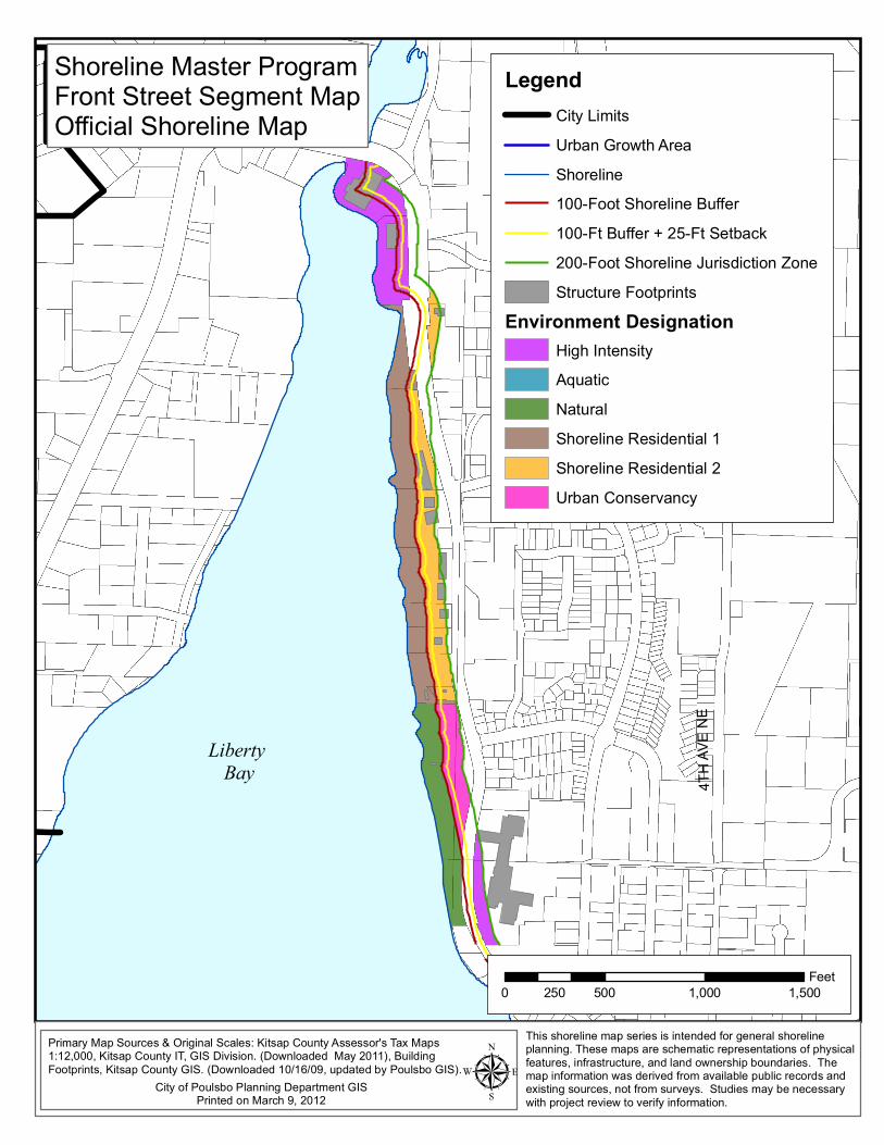
Shoreline Master ProgramFront Street Segment MapOfficial Shoreline Map
This shoreline map series is intended for general shoreline planning. These maps are schematic representations of physicalfeatures, infrastructure, and land ownership boundaries. The map information was derived from available public records and existing sources, not from surveys. Studies may be necessary with project review to verify information.
LegendCity LimitsUrban Growth AreaShoreline100-Foot Shoreline Buffer100-Ft Buffer + 25-Ft Setback200-Foot Shoreline Jurisdiction ZoneStructure Footprints
Environment DesignationHigh IntensityAquaticNaturalShoreline Residential 1Shoreline Residential 2Urban Conservancy
0 500 1,000 1,500250Feet
4TH A
VE N
E
City of Poulsbo Planning Department GISPrinted on March 9, 2012
Primary Map Sources & Original Scales: Kitsap County Assessor's Tax Maps 1:12,000, Kitsap County IT, GIS Division. (Downloaded May 2011), Building Footprints, Kitsap County GIS. (Downloaded 10/16/09, updated by Poulsbo GIS).
BO ND RD NE
1ST A
VE NE
NE BONDW OODDR (PVT)
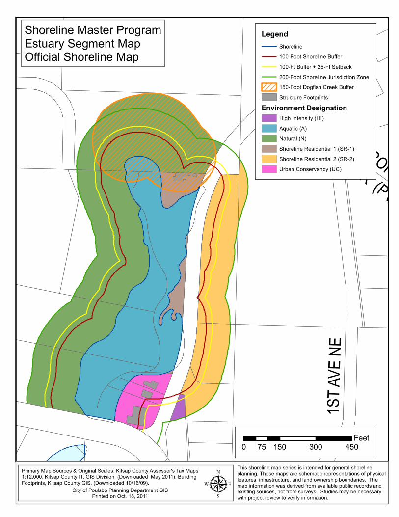
Shoreline M aster ProgramEstuary Segm ent M apO fficial Shoreline M ap
This shore line m ap se ries is in tended for general sho reline plann ing. These m aps a re schem atic rep resen ta tions o f physica lfea tures, infrastructu re, and land ow nership boundaries . The m ap inform ation w as de rived from available pub lic reco rds and ex is ting sources, not from su rveys. S tudies m ay be necessary w ith pro ject review to verify in fo rm ation.
LegendShoreline100-Foot Shoreline Bu ffer100-Ft Bu ffer + 25-F t S etback200-Foot Shoreline Jurisdic tion Zone150-Foot Dogfish C reek BufferStructu re Footp rints
Environment DesignationHigh In tens ity (H I)Aquatic (A )Natura l (N )Shore line R esiden tial 1 (SR -1)Shore line R esiden tial 2 (SR -2)Urban Conservancy (U C)
0 150 300 45075Feet
C ity o f Poulsbo P lanning D epartm en t G ISPrin ted on O ct. 18 , 2011
Prim ary M ap Sources & O rig inal Scales: K itsap C ounty A ssessor's Tax M aps 1:12,000 , K itsap C oun ty IT, G IS D iv is ion. (D ow n loaded M ay 2011), Bu ild ing Foo tp rints, K itsap C ounty G IS . (D ow nloaded 10/16/09 ).

Liberty Bay
Shoreline Master ProgramWestern Shoreline Segment MapOfficial Shoreline Map
This shoreline map series is intended for general shoreline planning. These maps are schematic representations of physicalfeatures, infrastructure, and land ownership boundaries. The map information was derived from available public records and existing sources, not from surveys. Studies may be necessary with project review to verify information.
0 500 1,000 1,500 2,000250Feet
LegendCity LimitsUrban Growth AreaShoreline100-Foot Shoreline Buffer100-Ft Buffer + 25-Ft Setback200-Foot Shoreline Jurisdiction ZoneStructure Footprints
Environment DesignationAquatic (A)High Intensity (HI)Natural (N)Shoreline Residential 1 (SR-1)Shoreline Residential 2 (SR-2)Urban Conservancy (UC)
Primary Map Sources & Original Scales: Kitsap County Assessor's Tax Maps 1:12,000, Kitsap County IT, GIS Division. (Downloaded May 2011), Building Footprints, Kitsap County GIS. (Downloaded 10/16/09, updated by Poulsbo GIS).
City of Poulsbo Planning Department GISPrinted on Oct. 25, 2011
VIKING
AVE N
W
NW LINDVIG WAY
NW BAY ST
NW LIBERTY RD