T:R0kNT AquifersNT GWater-Aquifers Map-2M-Updated-2018 …
1
Gas Pipeline Gas Pipeline Gas Pipeline Kata Tjuta Uluru Port McArthur Limmen Bight T r i a lB a y M e l v i l l e B a y M a l a y R o a d Brown Strait ARAFURA SEA GULF OF CARPENTARIA TIMOR SEA Juncti on Bay F i n k e B a y Gunn Point N a p i e r B a y C o b h a m B a y S n a k e B a y S h a r k B a y L e t h b r i d g e B a y Cape Cockburn Brogden Point Deception Point Rocky Point Cape Helvetlus Cape Keith Point Jahleel Vashon Head Cape Don Cape Scott Dooley Point Cape Hay Cape Ford Pearce Point P o r t K e at s H y l a n d B a y Cape Dombey VAN DIEMEN GULF BEAGLE GULF Point Blaze C h a n n e l P o i n t Cape Shield Cape Grey Cape Arnhem Pt Napier Cuthbert Point Cape Stewart Brathwaite Point Cape Wessel Cape Beatrice Cape Fourcroy Charles Point P o r t E s s i n g t o n JOSEPH BONAPARTE GULF D a lu m b u B a y C a le n d o n B a y P o r t B r a d s h a w Blue Mud Bay Arnhem Bay B u c ki n g h am B a y Boucaut Bay Castlereagh Bay Aurary Bay Dundas Strait C l arence S t ra i t G o r d o n B a y St Asaph B ay Anson Bay Fog Bay A d a m B a y S h o a l B a y Milner Bay D alyw oi B ay Chambers Bay Point Stuart Cape Croker Radford Point Cape Van Diemen TIMOR SEA ARAFURA SEA GULF OF CARPENTARIA TIMOR SEA ARAFURA SEA GULF OF CARPENTARIA TIMOR SEA ARAFURA SEA GULF OF CARPENTARIA TIMOR SEA ARAFURA SEA GULF OF CARPENTARIA North Island West Island Vanderlin Island South West I. Centre I. Hawknest Island Bickerton Island BATHURST ISLAND L a w so n I sl a n d O x l e y I sl a n d Vernon Islands GROOTE EYLANDT Bremer Island MELVILLE ISLAND COBURG PENINSULA Dum In Mirrie Island Peron Island North Peron Island South CROKER ISLAND McCluer Island Grant Island North Goulburn Is. South Goulburn Is. North West Crocodile Island Mooroongga Island Howard Island Elcho Island Drysdale Island Stevens Island WESSEL ISLANDS Marchinbar Island Guluwuru Island Wigram Island Truant Island Beatrice Island Maria Island Edward Island Sandy Island North East Isles Nicol Island Isle Woodah SIR EDWARD PELLEW GROUP PLENTY RIVER TODD RIVER K A T H E R I N E D U R A B U D B O I RIVER LANDER RIVER SANDOVER RIVER RANKEN RIVER RIVER HANSEN RIVER ROBINSON LIMMEN BIGHT RIVER RIVER MARY RIVER RIVER KEEP FINKE R I V E R N IC H O LSO N E L K E D R A R I V E R C A L V E R T RI V E R R I V E R M c A R T H U R R I V E R R O P E R G O Y D E R RIVER B L Y T H L I V E R P O O L R I V E R G O O M A D E E R R I V E R E A S T A L L I G A T O R R I V E R S O U T H R I V E R A L L I G A T O R W I L D M A N R I V E R F IN N IS S R I V E R D A L Y R I V E R M O Y L E R I V E R R I V E R F I T Z M A U R I C E R I V E R V IC T O R IA Sturt Creek FLORA RIVER RIVER RIVER DOUGLAS CATO R. R. Creek Jungle R. LATRAM Wonga Ck. Lake Argyle Nongra Lake Lake Sylvester Corella Lake Lake De Burgh Lake Bennett Lake Lewis Lake Dennis Lake White Lake Wills Lake Rapide Lake Amadeus Lake Neale Prentice Lake Lake Caroline Fiddlers Lake Lake Macdonald Lake Hopkins Lake Tarrabool Lake Buck (salt) Lake Woods Wickham River Spring Flora River Spring Rainbow Spring Bitter Springs Fig Tree Spring Coconut Spring Photo Spring Emerald River Spring Douglas Hot Spring Gakorrorodjh Wurrkal Spring Mt. Catt Spring Katherine Hot Spring Berry Springs Black Cockatoo Spring Nelson Spring Bubbling Sands Spring Nathan River Hot Spring Lorella Spring Howard Spring Hill Spring Bootu Creek McArthur River Gemco Mine Alcan Gove Mine Ranger Mine Tiwi Mineral Sands Granites / Tanami Operations (Groundrush) Granites / Tanami Operations (Dead Bullock Soak) Frances Creek Oil & Gas Pipeline Palm Valley Mereenie Gas Pipeline Bayu-Undan Gas Pipeline Pipeline Gas Bonaparte RN 5507 RN 7595 Mataranka Gunyangara Dhalinybuy Gurrumuru Birany Birany Baniyala Bing Bong Wandangula Yathalamarra Gochan Jiny-Jirra Weemol Rittarangu Cape Crawford Likkaparta Imangara Orrtipa-Thurra Engawala Manmoyi Eva Valley Djilkminggan Daly Waters Marlinja Mungkarta Wilora Iwupataka Batchelor Binjari Pigeon Hole Hatches Creek Larrimah Adelaide River Elliott Woodycupaldiya Gan Gan Rorruwuy Irrultja Tara Arawerr Mapurru Ngangalala Bulla Wurankuwu Urapunga Kybrook Farm Barkly Homestead (Roadhouse) Victoria River Roadhouse Pickertaramoor Hodgson River Lorella Curtin Springs (Roadhouse) Hayes Creek Emerald Springs Top Springs Cooinda Kulgera Tilmouth (Roadhouse) Barrow Creek Wauchope Wycliffe Well Renner Springs Mulga Park Rabbit Flat Dunmarra Bark Hut Inn Ti-Tree Chilla Well Gem Fields (Roadhouse) Three Ways (Roadhouse) Erldunda (Roadhouse) Burrundie Grove Hill Brocks Creek Union Town Rosewood Wallamunga Kirkimbie Newry Waterloo Birrindudu Legune Inverway Tanami Downs Limbunya Auvergne Bradshaw Mount Sanford Welltree Humbert River Fitzroy Victoria River Downs Coolibah Wombungi O/S Wave Hill Tipperary Camfield Innesvale Dorisvale Moolooloo O/S Douglas Willeroo Claravale Woolner Delamere Florina Jindare Montejinni Killarney Esmeralda Mary River Birrimba Dillinya Maud Creek Maranboy Koongarra Hidden Valley JaJa Anningie Nabarlek Highway Inn Kalala Maryfield Shenandoah Goomadeer Moroak Stirling Warrego Beetaloo Muckaty Orlando Banka Banka Mt Skinner Mainoru Woodgreen Ross River Brunchilly Todd River Mungabroom Cox River Kurundi Tanumbirini Eva Downs Ringwood Old Arafura Kurinelli O/S O T Downs Ammaroo Broadmere Elkedra Wallhallow Balbirini McArthur River Ooratippra Alroy Downs Lucy Creek Annitowa Argadargada Alexandria Tarlton Downs Warby O/S Manangoora Benmara Soudan Seven Emu Marqua Burramurra Avon Downs Tobermorey Andado Umbeara Lyndavale Mt Ebenezer Idracowra Allambi Henbury Tempe Downs Derwent Newhaven Mt Wedge Narwietooma Hamilton Downs Yambah Ambalindum Claraville Indiana Limbla Mt Denison Pine Hill Napperby Bushy Park Alcoota Dneiper Delny Arapunya Derry Downs Jinka Huckitta Singleton Tennant Creek Phillip Creek Bunda Dungowan Murranji Ucharonidge Mittiebah Greenbank Kiana Wyworrie Erldunda Atnarpa Numery Coniston Orange Creek Wongalara Wollogorang Cattle Creek Suplejack Downs Namul Namul Amburla Litchfield Brunette Downs McLaren Creek New Crown Victory Downs Mt. Cavenagh Lilla Creek The Garden Mt Riddock Georgina Downs Vaughan Springs Woola Downs Helen Springs Mistake Creek Powell Creek Litchfield OS Ban Ban Springs Elizabeth Downs Fergusson River Lewin Springs Bond Springs Nutwood Downs Mallapunyah Springs Bauhinia Downs Lonesome Dove Mountain Valley Spring Creek Austral Downs Bullo River Mount Ringwood Riveren Yariwoi District Rockhampton Downs Anthony Lagoon Macdonald Downs Deep Well Horseshoe Bend Victoria Settlement Granite / Tanami Operations Granite / Tanami Operations Kings Canyon Calvert Hills Manners Creek Glen Helen Scott Creek Nenen Larrizona Margaret Downs Bloodwood Downs Banjo Providence Gilnockie Tarlee Western Creek Middle Creek Birdum Creek Avago Sunday Creek Buchanan Downs Palmer Valley Aileron Murray Downs Neutral Junction Tandyidgee Amungee Mungee Vermelha Mount McMinn Conways Big River Flying Fox Goondooloo Manbulloo Lakefield Gorrie Cow Creek Cresswell Downs Dalmore Downs East Ranken West Ranken Epenarra Delmore Downs Jervois Ambalindum Lake Nash Rocklands Adder Mount Drummond Alexandria Pungalina Nturiya Borroloola Umbakumba Robinson River Alpurrurulam Gapuwiyak Bulman Numbulwar Ali Curung Ampilatwatja Atitjere Gunbalanya Jabiru Beswick Barunga Minyerri Willowra Pmara Jutunta Amoonguna Hermannsburg Wallace Rockhole Imanpa Belyuen Yarralin Daguragu Kalkarindji Lajamanu Nyirripi Haasts Bluff Mount Liebig Papunya Pirlangimpi Nguiu Wadeye Nganmarriyanga Peppimenarti Nauiyu Timber Creek Amanbidji Kintore Kaltukatjara Yulara Milingimbi Galiwinku Ramingining Yuelamu Yuendumu Canteen Creek Wutunugurra Warruwi Ngukurr Angurugu Maningrida Milikapiti Minjilang Laramba Mutitjulu Areyonga Finke Santa Teresa Titjikala Milyakburra Yirrkala Pine Creek Alyangula Finke Alyangula Papunya Areyonga Alpurrurulam Yuendumu Ali Curung Lajamanu Kalkarindji Wadeye Nguiu Numbulwar Ngukurr Bulman Maningrida Kulgera Daly Waters Mataranka Elliott Tanami Pine Creek Kaltukatjara Timber Creek Adelaide River Milikapiti Finke Alyangula Papunya Areyonga Alpurrurulam Yuendumu Ali Curung Lajamanu Kalkarindji Wadeye Nguiu Numbulwar Ngukurr Bulman Maningrida Kulgera Daly Waters Mataranka Elliott Tanami Pine Creek Kaltukatjara Timber Creek Adelaide River Milikapiti DARWIN KATHERINE TENNANT CREEK ALICE SPRINGS NHULUNBUY Tennant Creek Borroloola DARWIN Alice Springs Yulara Katherine Jabiru Nhulunbuy Tennant Creek Borroloola DARWIN Alice Springs Yulara Katherine Jabiru Nhulunbuy Tennant Creek Borroloola DARWIN Alice Springs Yulara Katherine Jabiru Nhulunbuy Tennant Creek Borroloola DARWIN Alice Springs Yulara Katherine Jabiru Nhulunbuy SANDOVER LURITJA BUCHANAN CALVERT ROAD NAMATJIRA ROAD ROAD ROAD HIGHWAY ROAD KINTORE ROAD PARK MULGA PARK DRIVE SANDOVER HIGHWAY ERNEST GILES HIGHWAY ROPER HIGHWAY DRIVE BUCHANAN ROAD MULGA LURITJA LARAPINTA HIGHWAY ROAD HIGHWAY BUNTINE ROAD HIGHWAY HIGHWAY HIGHWAY CARPENTARIA TANAMI ROAD HIGHWAY TABLELANDS HIGHWAY TANAMI PLENTY PLENTY CENTRAL ROAD CENTRAL ARNHEM ARNHEM KAKADU ARNHEM HIGHWAY LASSETER HIGHWAY BUNTINE HIGHWAY HIGHWAY STUART HIGHWAY STUART HIGHWAY BARKLY VICTORIA STUART HIGHWAY HIGHWAY VICTORIA STUART BARKLY HIGHWAY HIGHWAY HIGHWAY ARNHEM LAND TIWI ISLANDS DOUGLAS DALY REGION VICTORIA RIVER DISTRICT TANAMI DESERT SIMPSON DESERT BARKLY TABLELAND SOUTH AUSTRALIA QUEENSLAND WESTERN AUSTRALIA T A N A M I D E S E R T B A R K L Y T A B L E L A N D S I M P S O N D E S E R T A R N H E M L A N D V I C T O R I A R I V E R D I S T R I C T Great Artesian Basin D O U G L A S D A L Y R E G I O N T A N A M I D E S E R T B A R K L Y T A B L E L A N D S I M P S O N D E S E R T A R N H E M L A N D V I C T O R I A R I V E R D I S T R I C T D O U G L A S D A L Y R E G I O N T A N A M I D E S E R T B A R K L Y T A B L E L A N D S I M P S O N D E S E R T A R N H E M L A N D V I C T O R I A R I V E R D I S T R I C T Great Artesian Basin D O U G L A S D A L Y R E G I O N BULLWADDY CONSERVATION RESERVE CHAMBERS PILLAR HISTORICAL RESERVE WEST MACDONNELL NATIONAL PARK KEEP RIVER NATIONAL PARK RAINBOW VALLEY CONSERVATION RESERVE DULCIE RANGE NATIONAL PARK TREPHINA GORGE NATURE PARK ARLTUNGA HISTORICAL RESERVE ELSEY NATIONAL PARK MARY RIVER NATIONAL PARK KAKADU NATIONAL PARK KAKADU NATIONAL PARK LONGREACH WATERHOLE PROTECTED AREA JUNCTION RESERVE CONNELLS LAGOON CONSERVATION RESERVE WATARRKA NATIONAL PARK ULURU - KATA TJUTA NATIONAL PARK OWEN SPRINGS RESERVE FINKE GORGE NATIONAL PARK TNORALA (GOSSE BLUFF) CONSERVATION RESERVE RUBY GAP NATURE PARK LIMMEN NATIONAL PARK NITMILUK (KATHERINE GORGE) NATIONAL PARK LITCHFIELD NATIONAL PARK MARY RIVER NATIONAL PARK DAVENPORT RANGE NATIONAL PARK GARIG GUNAK BARLU NATIONAL PARK JUDBARRA / GREGORY NATIONAL PARK GIWINING / FLORA RIVER NATURE PARK JUDBARRA / GREGORY NATIONAL PARK FISH RIVER GORGE BLOCK HENBURY CONSERVATION PROJECT LIMMEN NATIONAL PARK LIMMEN NATIONAL PARK LIMMEN BIGHT MARINE PARK KARLU KARLU / DEVILS MARBLES CONSERVATION RESERVE BARRANYI (North Island) NATIONAL PARK CARANBIRINI CONSERVATION RESERVE KEEP RIVER NATIONAL PARK Extension (Proposed) WESTERN DAVENPORT ALICE SPRINGS TINDALL KATHERINE TENNANT CREEK GOVE DARWIN RURAL WESTERN DAVENPORT TI-TREE ALICE SPRINGS GREAT ARTESIAN BASIN DALY ROPER BEETALOO 1200 1300 1400 1500 200 300 400 500 600 700 800 900 1000 1100 E N W S 14^S 16^S 18^S 20^S 22^S 24^S 26^S 132^E 129^E 138^E 135^E 138^E 135^E 132^E 129^E 12^S 130^E 131^E 133^E 134^E 136^E 137^E 130^E 131^E 133^E 134^E 136^E 137^E 13^S 11^S 15^S 17^S 19^S 21^S 23^S 25^S 14^S 16^S 18^S 20^S 22^S 24^S 26^S 12^S 13^S 11^S 15^S 17^S 19^S 21^S 23^S 25^S All groundwaters contain dissolved salts, derived either from weathering of the host rock, from the minute amounts contained in rainfall or from evaporite deposits. The latter are salt deposits formed at the same time as the surrounding sedimentary rocks. The map depicts groundwater salinities measured from individual water bores. It shows generally low salinities in the north. In those areas, high rainfall, higher recharge rates and a faster through-flow of groundwater leads to less opportunity for salts to concentrate by evaporation in the soil before they are flushed down to the aquifer. The reverse is true in the arid zone to the south where salinities are highly variable and range up to values almost twice the concentration of seawater (34,000 mg/L TDS). Low salinities observed in the arid zone reflect localised areas of enhanced recharge such as along rivers and floodouts. Groundwater usually discharges at low-lying points in the landscape. It can take the form of individual springs or as diffuse seepage into stream beds. Recharge to groundwater is greatest in the higher rainfall zone in the north, so discharge is correspondingly greater. Many streams in the north maintain a flow for at least part of the long dry season because of groundwater discharge. Some streams, particularly those with major karstic or porous rock aquifers in their catchments, flow throughout the dry season. Springs with significant discharges (more than 100 L/s) only occur in karstic aquifers. Another mechanism for groundwater discharge is where trees in the riparian zone directly tap the watertable. This occurs throughout the Territory, but in the arid south it is thought to be the dominant process along with discharge through salt lakes. This map shows recorded springs and streams that flow throughout the dry season. The streams have been classified according to their flows at the end of the dry season. The classification only extends to the tidal limit, so some streams such as the Roper River appear to stop before reaching the coast. The map shows the most likely range of bore yields that can be expected for a particular area. Note that higher or lower yields can be encountered depending on local conditions. The higher yields (more than 5.0 Litres/second) occur in fractured and karstic aquifers. Most fractured rock aquifers give intermediate yields (0.5 - 5.0 Litres/second), while low yielding aquifers include granite and shale. This publication is protected by copyright law and remains the property of the Northern Territory of Australia. Apart from any uses as permitted under the Copyright Act 1968 for study research or training purposes, reproduction by whatever means is prohibited, without prior written permission from the custodian. The Northern Territory accepts no liability for the accuracy of the information provided. Furthermore the Northern Territory of Australia does not warrant that this product contains the latest information available nor that the information is free from errors. A relict drainage system that formed in the Tertiary era between 2 and 65 million years ago is preserved in the south western part of the Territory. It comprises small sedimentary basins and narrow palaeovalleys. Aquifers are developed in river sands and gravels that form part of the channel and basin fills. Shallow calcrete layers can host fractured and karstic aquifers. Apart from the Ti-Tree Basin and some palaeovalleys in the Tanami desert, few of these deposits have been investigated for their groundwater potential. This map has been compiled from geological maps, satellite imagery and water bore data. In many places it is highly speculative due to the sparse drilling in those areas. C Northern Territory of Australia This map was produced on the Geocentric Datum of Australia 1994 (GDA 94) A prominent area of saline groundwaters to the north east of Tennant Creek reflects extensive evaporites within the Georgina Basin. Both gypsum (calcium sulphate) and halite (sodium chloride) occur in the rocks of that area. Source: Hydstra Database and existing hydrogeological maps.Northern Territory Department of Environment and Natural Resources. Source: Paleovalley Groundwater Project, Northern Territory Department of Environment and Natural Resources and Geoscience Australia, Australian Government. Source: Hydstra Database. Northern Territory Department of Environment and Natural Resources. Median Annual Rainfall, 2003. Bureau of Meterology. Australian Government. Source: Hydstra Database. Northern Territory Department of Environment and Natural Resources. 1 : 2 500 000 scale digital geology, Geological Survey, Northern Territory Department of Mines and Energy. Produced by the Department of Environment and Natural Resources (DENR) Palmerston, Northern Territory, Australia. Original Map July 2013 Updated Water Control District and Allocation Plan, August 2018 Hydrogeology: S J Tickell, July 2013 Water Resources Division, DENR Cartography: L J Fritz, Geospatial Services, Water Resources Division, DENR For further Information and map availability, contact: Water Resources Division Department of Environment and Natural Resources (DENR) 4th floor Goyder Centre, 25 Chung Wah Terrace, Palmerston. T: (08) 8999 4455 Email: [email protected] P.O. Box 496, Palmerston, 0831. Northern Territory, Australia. Internet: www.denr.nt.gov.au Map Reference: Groundwater of the Northern Territory The recommended reference for this map is: Tickell SJ, 2013. Groundwater of the Northern Territory, 1:2 000 000 scale. Department of Environment and Natural Resources, Northern Territory. SPRINGS END OF DRY SEASON FLOWS DISCHARGE Salt Lake Greater than 100 Litres/second 10 to 100 Litres/second Up to 10 Litres/second AQUIFER Karstic Aquifers GROUNDWATER SALINITY BORE YIELD 250 km 0 500 km 0.05 - 0.5 Litres/second 0.5 - 2.5 Litres/second 0.5 - 5.0 Litres/second 5.0 - 10.0 Litres/second 5.0 - 50.0 Litres/second YIELD SALINITY and RAINFALL PALAEOVALLEYS GROUNDWATER DISCHARGE Gas pipeline Railway LEGEND Main Population Centre Major Population Centre Minor Population Centre Property boundary State / Territory border Road - State Arterial Road - National Highway Road - Secondary 50 0 100 kilometres 50 200 kilometres 150 Gas Field, Oil & Gas Field Locality Ti-Tree Barunga Jilkminggan Mine - Open Pit, Underground OWEN SPRINGS RESERVE Water Control District Barrow Creek Rainfall 5 Year Moving Average Rainfall Groundwater Level Bore RN 7595 Groundwater Level Bore RN 5507 Annual Rainfall (mm) TOTAL DISSOLVED SOLIDS (TDS) 400 0 - 500 mg/L Fresh 500 - 1000 mg/L 1000 - 3000 mg/L Fresh Brackish 3000 - 7000 mg/L 7000 - 14000 mg/L 14000 - 59000 mg/L Saline Saline Saline, unsuitable for most purposes Human Consumption Domestic Irrigation Stock Watercourse, Major Spring RN 5507 Observation Bore / Number Note: The observation bores RN 7595 (west of Katherine) and RN 5507 (near Ti-Tree) are marked on the main map Lamberts Conformal Conic Projection Standard Parallels, (1st) 12^40" South and (2nd) 23^20’ South Central Meridian 133^ 30’ East Geocentric Datum of Australia 1994 (GDA94) Warning: Colours will fade with prolonged exposure to light Palaeovalleys and Sedimentary Basins Florina DARWIN A U S T R A L I A NORTHERN TERRITORY WESTERN AUSTRALIA SOUTH AUSTRALIA QUEENSLAND NEW SOUTH WALES VICTORIA TASMANIA 250 km 0 500 km 250 km 0 500 km 250 km 0 500 km National Park, Reserve or managed for conservation Water Allocation Plan Water Control District and Water allocation Plan TI-TREE GOVE Pastoral property 0 2500 2000 1500 1000 500 60 30 1968 1970 1972 1974 1976 1978 1980 1982 1984 1986 1988 1990 1992 1994 1996 1998 2000 2002 2004 2006 1968 1970 1972 1974 1976 1978 1980 1982 1984 1986 1988 1990 1992 1994 1996 1998 2000 2002 2004 2006 0 2500 2000 1500 1000 500 55 50 45 40 35 No Record No Record KATHERINE BARROW CREEK Katherine Annual Rainfall ANNUAL RAINFALL (mm) ANNUAL RAINFALL (mm) GROUNDWATER LEVEL (metres above sea level) TI-TREE 2008 2010 2012 2008 2010 2012 5 Year Moving Average Rainfall 65 530 535 540 545 550 555 560 GROUNDWATER LEVEL (metres above sea level) 565 This refers to the distance over which groundwater flows through the aquifers from recharge to discharge areas. Local - less than 5 kilometres Intermediate - 5 to 50 kilometres Regional - more than 50 kilometres The majority of aquifers in the Northern Territory are developed in networks of fractures (cracks) in hard rocks. Their extent depends on the intensity of fracturing and the degree to which fractures are connected with each other. Fractures are more commonly open in weathered rock and so more capable of storing and transmitting groundwater. The highest yielding zones are often situated at the base of weathered rock. This typically varies between 30 and 80 metres, depending on the region. Extensive sedimentary basins containing limestone and dolomite support "Karstic" aquifers formed both by fractures and also by solution cavities ranging up to the size of caves. Aquifers that have primary intergranular porosity are formed in both unconsolidated sediments (e.g. river gravels) and in older sandstones. The extents of the former are poorly known. The Ti-Tree Basin and an alluvial aquifer in the Keep River area are the only "unconsolidated sediment" aquifers shown on the main map. Others are shown on the "Palaoevalleys" side map. Sedimentary rocks with intergranular porosity. Regional to local scale aquifers Fractured and Weathered Rocks with some intergranular porosity. Intermediate scale aquifers. Fractured and Weathered Rocks. Local scale aquifers. Fractured and Weathered Rocks with minor groundwater resources. Local scale aquifers. Fractured and Karstic Rocks. Local and intermediate scale aquifers. AQUIFER SCALE AQUIFERS AQUIFER TYPES GROUNDWATER of the NORTHERN TERRITORY Unconsolidated sediments with intergranular porosity. Intermediate scale aquifers Note: The boxes on the left give schematic view of the aquifers. Source: 1 : 2 500 000 scale digital geology, 1 : 2 500 000 scale digital geology, Geological Survey, Northern Territory Department of Mines and Energy. Fractured and Karstic Rocks. Regional scale aquifers. Springs Major Springs Hydstra Database and existing hydrogeological mapping. Northern Territory Department of Environment and Natural Resources.
Transcript of T:R0kNT AquifersNT GWater-Aquifers Map-2M-Updated-2018 …
KATH
ERINE
RIVER
RIVER
KATH
ERINE
Ga
s P
ipe
line
Ga
s P
ipe
line
Ga
s P
ipe
line
Kata TjutaUluru
Port
McArthur
LimmenBight
Trial Bay
Me
lvilleB
ay
Mala
y RoadBrow
n St
rait
ARAFURA SEA
GULF
OF
CARPENTARIA
TIMOR
SEA
Junction Bay
Fin
keBay
Gunn Point
Napier Bay
Co
bhamBay
Sna
keB
ay
Sh
ark
Bay
Let
hb
rid
ge
Bay
Cape Cockburn
Brogden Point
Deception Point
Rocky Point
Cape Helvetlus
Cape Keith
PointJahleel
Vashon Head
CapeDon
Cape Scott
Dooley Point
Cape Hay
Cape Ford
Pearce Point
Port
Kea
ts
Hyland Bay
CapeDombey
VAN DIEMEN GULF
BEAGLE GULF
Point Blaze
Channel Point
Cape Shield
Cape Grey
Cape Arnhem
Pt Napier
CuthbertPoint
CapeStewart
Brathwaite Point
CapeWessel
Cape Beatrice
Cape Fourcroy
Charles Point
Port Essingto
n
JOSEPH
BONAPARTE
GULF
Dalumbu Bay
Calendon Bay
Port Bradshaw
Blue
Mud
Bay
ArnhemBay
Buckingham Bay
Boucaut Bay
CastlereaghBay
AuraryBay
Du
nd
as S
trait
ClarenceStrait
Gordon Bay
St Asaph Bay
AnsonBay
FogBay
Ad
am
Ba
y
Shoal Bay
Milner Bay
Dalywoi Bay
Chambers Bay
PointStuart
CapeCroker
RadfordPoint
CapeVan Diemen
TIMOR
SEA
ARAFURA SEA
GULF
OF
CARPENTARIA
TIMOR
SEA
ARAFURA SEA
GULF
OF
CARPENTARIA
TIMOR
SEA
ARAFURA SEA
GULF
OF
CARPENTARIA
TIMOR
SEA
ARAFURA SEA
GULF
OF
CARPENTARIA
NorthIslandWest
Island
VanderlinIsland
SouthWest I.
Centre I.
HawknestIsland
BickertonIsland
BATHURST
ISLAND
Lawson IslandOxley Island
VernonIslands
GROOTE
EYLANDT
BremerIsland
MELVILLE ISLAND
COBURG PENINSULA
Dum In Mirrie Island
Peron Island North
Peron Island South
CROKERISLAND McCluer Island
Grant Island
North Goulburn Is.
South Goulburn Is.North West
Crocodile Island
MooroonggaIsland
HowardIsland
Elcho Island
Drysdale Island
Stevens Island WESSEL
ISLAN
DS Marchinbar Island
Guluwuru Island
WigramIsland
Truant Island
Beatrice Island
Maria Island
Edward Island
Sandy Island
North EastIsles
Nicol Island
Isle Woodah
SIR EDWARD PELLEW GROUP
PL
EN
TY
RIV
ER
TODD
RIV
ER
KATHERIN
E
DU
RA
BU
DB
OI
RIVER
LAN
DE
R
RIVER
SANDOVER
RIVER
RA
NK
EN
RIV
ER
RIVER
HA
NS
EN
RIVER
RO
BIN
SON
LIM
ME
N
BIG
HT
RIVER
RIV
ER
MA
RY
RIVER
RIV
ER
KE
EP
FIN
KE
RIVERNICHOLSON
ELKEDRA
RIV
E
R
CA
LV
ER
T
RIVE
R
RIV
ER
McA
RTH
UR
RIVERROPER
GO
YD
ER
RIV
ER
BLYTH
LIV
ER
PO
OL
RIV
ER
GO
OM
AD
EE
R
RIV
ER
EAST
ALLIGATOR
RIV
ER
SO
UT
H
RIVER
AL
LIG
AT
OR
WILDMAN
RIV
ER
FINNISS
RIV
ER
DALY
RIVER
MOYLE
RIV
ER
RIVERFITZMAURICE
RIV
ER
VICTORIA
Sturt
Cre
ek
FLORARIVER
RIVER
RIVER
DOUGLAS
CA
TO
R.
R.
Creek
Jung
le
R.
LATRAM
Wonga
Ck.
Lake
Argyle
NongraLake
LakeSylvester
CorellaLake
LakeDe Burgh
LakeBennett
LakeLewis
LakeDennis
Lake White
Lake Wills
LakeRapide
Lake Amadeus
Lake Neale
PrenticeLake
LakeCaroline
FiddlersLake
LakeMacdonald
LakeHopkins
LakeTarrabool
Lake Buck(salt)
LakeWoods
Wickham RiverSpring
FloraRiver
Spring
RainbowSpring
BitterSprings
Fig TreeSpring
Coconut Spring
Photo Spring
Emerald RiverSpring
DouglasHot Spring
Gakorrorodjh
Wurrkal Spring
Mt. Catt Spring
Katherine Hot Spring
BerrySprings
Black CockatooSpring
Nelson Spring
Bubbling SandsSpring
Nathan RiverHot Spring
LorellaSpring
HowardSpring
Hill Spring
Bootu Creek
McArthur River
Gemco Mine
Alcan Gove Mine
Ranger Mine
Tiwi Mineral Sands
Granites / Tanami Operations(Groundrush)
Granites / Tanami Operations(Dead Bullock Soak)
FrancesCreek
Oil & Gas Pipeline
Palm ValleyMereenie
GasPipelin
e
Bayu-Undan Gas Pipeline
Pipelin
e
Gas
Bonaparte
RN 5507
RN 7595
Mataranka
Gunyangara
Dhalinybuy
Gurrumuru
BiranyBirany
Baniyala
Bing Bong
Wandangula
Yathalamarra
GochanJiny-Jirra
Weemol
Rittarangu
Cape Crawford
Likkaparta
Imangara
Orrtipa-ThurraEngawala
Manmoyi
EvaValley
Djilkminggan
Daly Waters
Marlinja
Mungkarta
Wilora
Iwupataka
Batchelor
Binjari
Pigeon Hole
Hatches Creek
Larrimah
Adelaide River
Elliott
Woodycupaldiya
Gan Gan
Rorruwuy
Irrultja
Tara
Arawerr
MapurruNgangalala
Bulla
Wurankuwu
Urapunga
KybrookFarm
Barkly Homestead(Roadhouse)
Victoria RiverRoadhouse
Pickertaramoor
HodgsonRiver
Lorella
Curtin Springs(Roadhouse)
HayesCreek Emerald
Springs
Top Springs
Cooinda
Kulgera
Tilmouth (Roadhouse)
Barrow Creek
Wauchope
Wycliffe Well
Renner Springs
Mulga Park
Rabbit Flat
Dunmarra
Bark Hut Inn
Ti-Tree
Chilla Well
Gem Fields(Roadhouse)
Three Ways (Roadhouse)
Erldunda(Roadhouse)
Burrundie
Grove Hill
BrocksCreek
UnionTown
Rosewood
Wallamunga
Kirkimbie
Newry
Waterloo
Birrindudu
Legune
Inverway
Tanami Downs
Limbunya
Auvergne
Bradshaw
Mount Sanford
Welltree
Humbert River
Fitzroy
Victoria River Downs
Coolibah
Wombungi O/S
Wave Hill
Tipperary
Camfield
Innesvale
Dorisvale
Moolooloo O/S
Douglas
Willeroo
Claravale
Woolner
Delamere
Florina
Jindare
Montejinni
Killarney
Esmeralda
Mary River
Birrimba
Dillinya
Maud Creek
Maranboy
Koongarra
Hidden Valley
JaJa
Anningie
Nabarlek
Highway Inn
Kalala
Maryfield
Shenandoah
Goomadeer
Moroak
Stirling
Warrego
Beetaloo
Muckaty
Orlando
Banka Banka
Mt Skinner
Mainoru
Woodgreen
Ross River
Brunchilly
Todd River
Mungabroom
Cox River
Kurundi
Tanumbirini
Eva Downs
Ringwood
Old Arafura
Kurinelli O/S
O T Downs
Ammaroo
Broadmere
Elkedra
Wallhallow
Balbirini
McArthur River
Ooratippra
Alroy Downs
Lucy Creek
Annitowa
Argadargada
Alexandria
Tarlton Downs
Warby O/S
Manangoora
Benmara
Soudan
Seven Emu
Marqua
Burramurra
Avon Downs
Tobermorey
Andado
Umbeara
Lyndavale
Mt Ebenezer
Idracowra
Allambi
Henbury
Tempe Downs
Derwent
NewhavenMt Wedge
Narwietooma
Hamilton Downs
Yambah
Ambalindum Claraville Indiana
Limbla
Mt Denison
Pine Hill
Napperby
BushyPark
Alcoota
Dneiper
Delny
Arapunya
Derry Downs
JinkaHuckitta
Singleton
Tennant Creek
Phillip Creek
Bunda
Dungowan
Murranji
Ucharonidge
Mittiebah
Greenbank
Kiana
Wyworrie
Erldunda
Atnarpa
Numery
Coniston
Orange Creek
Wongalara
Wollogorang
Cattle Creek
Suplejack Downs
Namul Namul
Amburla
Litchfield
Brunette Downs
McLaren Creek
New Crown
Victory DownsMt. Cavenagh
Lilla Creek
The Garden
Mt Riddock
Georgina Downs
Vaughan Springs
Woola Downs
Helen Springs
Mistake Creek
Powell Creek
Litchfield OS
Ban BanSprings
ElizabethDowns
FergussonRiver
LewinSprings
BondSprings
Nutwood Downs
MallapunyahSprings
BauhiniaDowns
Lonesome Dove
MountainValley
SpringCreek
AustralDowns
Bullo River
MountRingwood
Riveren
YariwoiDistrict
RockhamptonDowns
AnthonyLagoon
MacdonaldDowns
DeepWell
HorseshoeBend
Victoria Settlement
Granite / TanamiOperations
Granite / TanamiOperations
Kings Canyon
CalvertHills
MannersCreek
GlenHelen
Scott Creek
Nenen
LarrizonaMargaretDowns
BloodwoodDowns
Banjo
ProvidenceGilnockie Tarlee
WesternCreek
MiddleCreek
BirdumCreek
AvagoSundayCreek
Buchanan Downs
Palmer Valley
Aileron
Murray Downs
NeutralJunction
Tandyidgee
Amungee Mungee
Vermelha
Mount McMinn
Conways
BigRiver
FlyingFox
Goondooloo
Manbulloo
Lakefield
Gorrie
CowCreek
Cresswell Downs
Dalmore Downs
EastRanken
WestRanken
Epenarra
DelmoreDowns
Jervois
Ambalindum
Lake Nash
Rocklands
Adder
Mount Drummond
Alexandria
Pungalina
Nturiya
Borroloola
Umbakumba
RobinsonRiver
Alpurrurulam
Gapuwiyak
Bulman
Numbulwar
Ali Curung
Ampilatwatja
Atitjere
Gunbalanya
Jabiru
Beswick
Barunga
Minyerri
Willowra
Pmara Jutunta
Amoonguna
Hermannsburg
WallaceRockhole
Imanpa
Belyuen
Yarralin
Daguragu
Kalkarindji
Lajamanu
Nyirripi
Haasts Bluff
Mount Liebig
Papunya
Pirlangimpi
Nguiu
Wadeye
Nganmarriyanga
Peppimenarti
Nauiyu
Timber Creek
Amanbidji
Kintore
Kaltukatjara
Yulara
MilingimbiGaliwinku
Ramingining
YuelamuYuendumu
Canteen Creek
Wutunugurra
Warruwi
Ngukurr
Angurugu
Maningrida
Milikapiti
Minjilang
Laramba
Mutitjulu
Areyonga
Finke
Santa Teresa
Titjikala
Milyakburra
Yirrkala
Pine Creek Alyangula
Finke
Alyangula
Papunya
Areyonga
Alpurrurulam
Yuendumu
Ali Curung
Lajamanu
Kalkarindji
Wadeye
Nguiu
Numbulwar
Ngukurr
Bulman
Maningrida
Kulgera
Daly Waters
Mataranka
Elliott
Tanami
Pine Creek
Kaltukatjara
TimberCreek
Adelaide River
Milikapiti
Finke
Alyangula
Papunya
Areyonga
Alpurrurulam
Yuendumu
Ali Curung
Lajamanu
Kalkarindji
Wadeye
Nguiu
Numbulwar
Ngukurr
Bulman
Maningrida
Kulgera
Daly Waters
Mataranka
Elliott
Tanami
Pine Creek
Kaltukatjara
TimberCreek
Adelaide River
Milikapiti
DARWIN
KATHERINE
TENNANT CREEK
ALICE SPRINGS
NHULUNBUY
Tennant Creek
Borroloola
DARWIN
Alice Springs
Yulara
Katherine
Jabiru
Nhulunbuy
Tennant Creek
Borroloola
DARWIN
Alice Springs
Yulara
Katherine
Jabiru
Nhulunbuy
Tennant Creek
Borroloola
DARWIN
Alice Springs
Yulara
Katherine
Jabiru
Nhulunbuy
Tennant Creek
Borroloola
DARWIN
Alice Springs
Yulara
Katherine
Jabiru
Nhulunbuy
SANDOVER
LUR
ITJA
BUCHANAN
CALVERT
ROAD
NAMATJIRA
ROAD
ROAD
RO
AD
HIGHWAY
RO
AD
KINTORE
ROAD
PAR
K
MULGA PARK
DRIVE
SANDOVER
HIGHWAY
ERNEST GILES
HIGHWAY
ROPER
HIGHWAY
DRIVE
BUCH
ANAN
ROAD
MU
LGA
LURITJA
LARAPINTA
HIGHWAY
ROAD
HIG
HW
AY
BUN
TINE
ROAD
HIGHWAY
HIG
HW
AY
HIGHWAY
CARPENTARIA
TANAMI
ROAD
HIGHWAY
TABLELANDS
HIGHWAY
TANAMI
PLENTY
PLENTY
CENTRAL
ROAD
CENTRAL
ARNHEM
ARNHEM
KAKA
DU
ARNHEM
HIG
HW
AY
LASSETER
HIGHWAY
BUNTINE
HIGHWAY
HIGHWAY
STUA
RT
HIG
HW
AY
STU
AR
T
HIG
HW
AY
BARKLY
VICTO
RIA
STUA
RT
HIGHW
AY
HIGHWAY
VICTORIA
STUART
BARKLYHIGHWAY
HIGHW
AY
HIGHWAY
A R N H E M L A N D
T I W I I S L A N D S
D O U G L A S D A L YR E G I O N
V I C T O R I A R I V E RD I S T R I C T
T A N A M I D E S E R T
S I M P S O N D E S E R T
B A R K L Y
T A B L E L A N D
SOUTH AUSTRALIA
QU
EE
NS
LA
ND
WE
ST
ER
N A
US
TR
AL
IA
T A N A M I
D E S E R T
B A R K L Y
T A B L E L A N D
S I M P S O N
D E S E R T
A R N H E M L A N D
V I C T O R I A
R I V E R
D I S T R I C T
Great Artesian Basin
D O U G L A SD A L Y
R E G I O N
T A N A M I
D E S E R T
B A R K L Y
T A B L E L A N D
S I M P S O N
D E S E R T
A R N H E M L A N D
V I C T O R I A
R I V E R
D I S T R I C T
D O U G L A SD A L Y
R E G I O N
T A N A M I
D E S E R T
B A R K L Y
T A B L E L A N D
S I M P S O N
D E S E R T
A R N H E M L A N D
V I C T O R I A
R I V E R
D I S T R I C T
Great Artesian Basin
D O U G L A SD A L Y
R E G I O N
BULLWADDYCONSERVATION
RESERVE
CHAMBERS PILLARHISTORICAL RESERVE
WEST MACDONNELLNATIONAL PARK
KEEP RIVERNATIONAL PARK
RAINBOW VALLEYCONSERVATION RESERVE
DULCIE RANGENATIONAL PARK
TREPHINA GORGENATURE PARK
ARLTUNGA HISTORICAL RESERVE
ELSEY NATIONAL PARK
MARYRIVER
NATIONALPARK
KAKADU NATIONAL PARK
KAKADU NATIONAL PARK
LONGREACH WATERHOLEPROTECTED AREA
JUNCTIONRESERVE
CONNELLSLAGOON
CONSERVATIONRESERVE
WATARRKANATIONAL PARK
ULURU - KATA TJUTANATIONAL PARK
OWEN SPRINGSRESERVE
FINKEGORGE
NATIONALPARK
TNORALA(GOSSE BLUFF)CONSERVATION
RESERVE
RUBY GAPNATURE PARK
LIMMEN
NATIONAL
PARK
NITMILUK(KATHERINE GORGE)
NATIONAL PARK
LITCHFIELD
NATIONAL
PARK
MARYRIVER
NATIONALPARK
DAVENPORTRANGE
NATIONALPARK
GARIG GUNAK BARLUNATIONAL PARK
JUDBARRA / GREGORY
NATIONAL
PARK
GIWINING / FLORA RIVERNATURE PARK
JUDBARRA /GREGORYNATIONAL
PARK
FISH RIVERGORGE BLOCK
HENBURY CONSERVATIONPROJECT
LIMMEN
NATIONAL PARK
LIMMEN
NATIONAL
PARK
LIMMEN BIGHTMARINE PARK
KARLU KARLU / DEVILS MARBLESCONSERVATION RESERVE
BARRANYI (North Island)NATIONAL PARK
CARANBIRINICONSERVATION
RESERVE
KEEP RIVERNATIONAL PARK
Extension (Proposed)
WESTERNDAVENPORT
ALICE SPRINGS
TINDALLKATHERINE
T E N N A N TC R E E K
G O V E
D A R W I NR U R A L
W E S T E R ND A V E N P O R T
T I - T R E E
A L I C ES P R I N G S
G R E A T A R T E S I A N B A S I N
D A L Y R O P E R B E E T A L O O
1200
1300
1400
1500
200
300
400
500
600
700
800
9001000
1100
E
N
W
S
14^S
16^S
18^S
20^S
22^S
24^S
26^S
132^E129^E 138^E135^E
138^E135^E132^E129^E
12^S
130^E 131^E 133^E 134^E 136^E 137^E
130^E 131^E 133^E 134^E 136^E 137^E
13^S
11^S
15^S
17^S
19^S
21^S
23^S
25^S
14^S
16^S
18^S
20^S
22^S
24^S
26^S
12^S
13^S
11^S
15^S
17^S
19^S
21^S
23^S
25^S
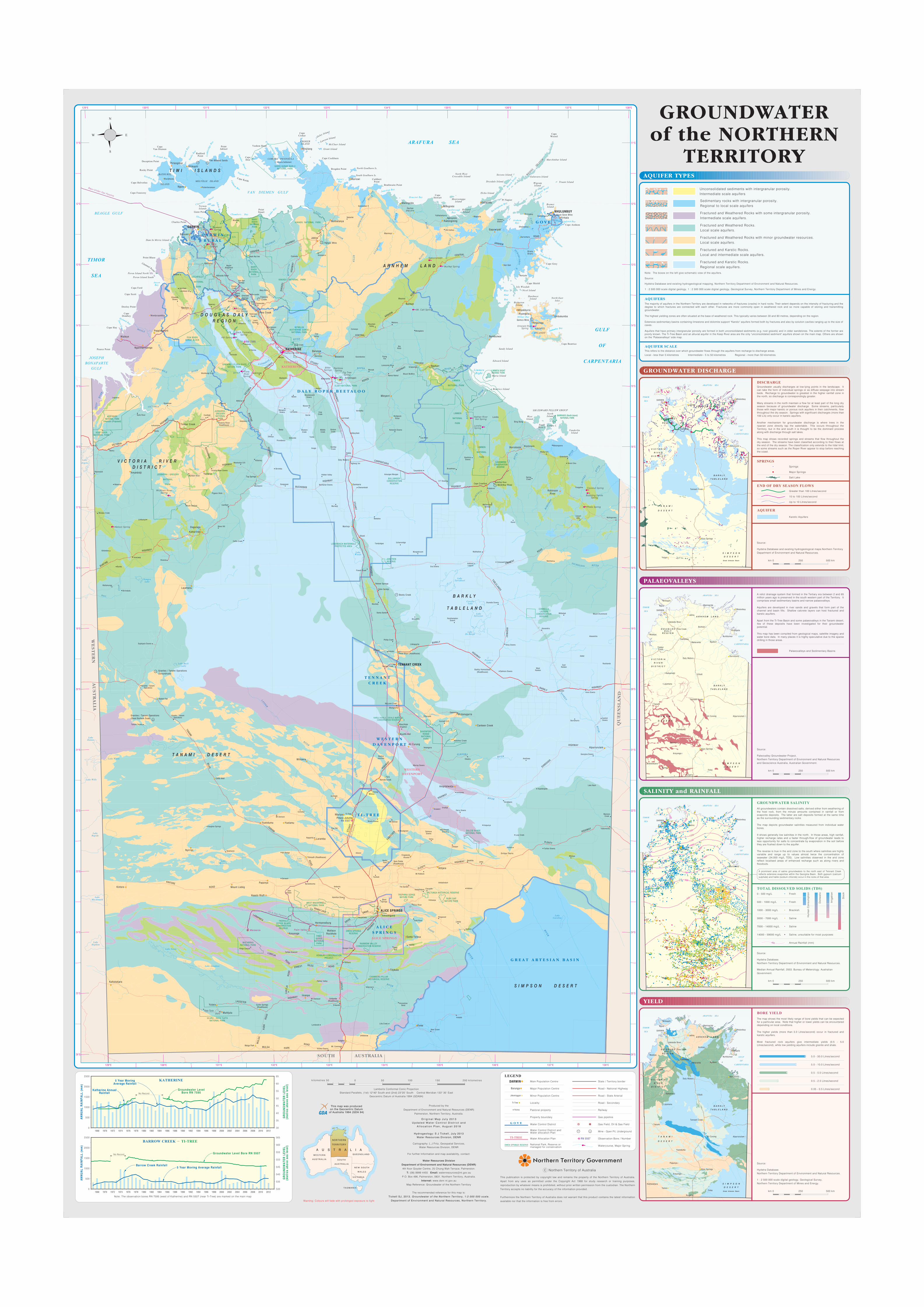
All groundwaters contain dissolved salts, derived either from weathering ofthe host rock, from the minute amounts contained in rainfall or fromevaporite deposits. The latter are salt deposits formed at the same timeas the surrounding sedimentary rocks.
The map depicts groundwater salinities measured from individual waterbores.
It shows generally low salinities in the north. In those areas, high rainfall,higher recharge rates and a faster through-flow of groundwater leads toless opportunity for salts to concentrate by evaporation in the soil beforethey are flushed down to the aquifer.
The reverse is true in the arid zone to the south where salinities are highlyvariable and range up to values almost twice the concentration ofseawater (34,000 mg/L TDS). Low salinities observed in the arid zonereflect localised areas of enhanced recharge such as along rivers andfloodouts.
Groundwater usually discharges at low-lying points in the landscape. Itcan take the form of individual springs or as diffuse seepage into streambeds. Recharge to groundwater is greatest in the higher rainfall zone inthe north, so discharge is correspondingly greater.
Many streams in the north maintain a flow for at least part of the long dryseason because of groundwater discharge. Some streams, particularlythose with major karstic or porous rock aquifers in their catchments, flowthroughout the dry season. Springs with significant discharges (more than100 L/s) only occur in karstic aquifers.
Another mechanism for groundwater discharge is where trees in theriparian zone directly tap the watertable. This occurs throughout theTerritory, but in the arid south it is thought to be the dominant processalong with discharge through salt lakes.
This map shows recorded springs and streams that flow throughout thedry season. The streams have been classified according to their flows atthe end of the dry season. The classification only extends to the tidal limit,so some streams such as the Roper River appear to stop before reachingthe coast.
The map shows the most likely range of bore yields that can be expectedfor a particular area. Note that higher or lower yields can be encountereddepending on local conditions.
The higher yields (more than 5.0 Litres/second) occur in fractured andkarstic aquifers.
Most fractured rock aquifers give intermediate yields (0.5 - 5.0Litres/second), while low yielding aquifers include granite and shale.
This publication is protected by copyright law and remains the property of the Northern Territory of Australia.
Apart from any uses as permitted under the Copyright Act 1968 for study research or training purposes,
reproduction by whatever means is prohibited, without prior written permission from the custodian. The Northern
Territory accepts no liability for the accuracy of the information provided.
Furthermore the Northern Territory of Australia does not warrant that this product contains the latest information
available nor that the information is free from errors.
A relict drainage system that formed in the Tertiary era between 2 and 65million years ago is preserved in the south western part of the Territory. Itcomprises small sedimentary basins and narrow palaeovalleys.
Aquifers are developed in river sands and gravels that form part of thechannel and basin fills. Shallow calcrete layers can host fractured andkarstic aquifers.
Apart from the Ti-Tree Basin and some palaeovalleys in the Tanami desert,few of these deposits have been investigated for their groundwaterpotential.
This map has been compiled from geological maps, satellite imagery andwater bore data. In many places it is highly speculative due to the sparsedrilling in those areas.
C Northern Territory of Australia
This map was producedon the Geocentric Datum
of Australia 1994 (GDA 94)
A prominent area of saline groundwaters to the north east of Tennant Creekreflects extensive evaporites within the Georgina Basin. Both gypsum (calciumsulphate) and halite (sodium chloride) occur in the rocks of that area.
Source:
Hydstra Database and existing hydrogeological maps.Northern TerritoryDepartment of Environment and Natural Resources.
Source:
Paleovalley Groundwater Project,Northern Territory Department of Environment and Natural Resourcesand Geoscience Australia, Australian Government.
Source:
Hydstra Database.Northern Territory Department of Environment and Natural Resources.
Median Annual Rainfall, 2003. Bureau of Meterology. AustralianGovernment.
Source:
Hydstra Database.Northern Territory Department of Environment and Natural Resources.
1 : 2 500 000 scale digital geology, Geological Survey,Northern Territory Department of Mines and Energy.
Produced by the
Department of Environment and Natural Resources (DENR)
Palmerston, Northern Territory, Australia.
O r i g i n a l M a p J u l y 2 0 1 3U p d a t e d W a t e r C o n t r o l D i s t r i c t a n d
A l l o c a t i o n P l a n , A u g u s t 2 0 1 8
Hydrogeology: S J Tickel l , Ju ly 2013Water Resources Div is ion, DENR
Cartography: L J Fritz, Geospatial Services,Water Resources Division, DENR
For further Information and map availability, contact:
Water Resources Division
Department of Environment and Natural Resources (DENR)
4th floor Goyder Centre, 25 Chung Wah Terrace, Palmerston.
T: (08) 8999 4455 Email: [email protected]
P.O. Box 496, Palmerston, 0831. Northern Territory, Australia.
Internet: www.denr.nt.gov.au
Map Reference: Groundwater of the Northern Territory
The recommended reference for this map is:
Tickel l SJ, 2013. Groundwater of the Nor thern Terr i tory , 1:2 000 000 scale.
Department of Envi ronment and Natura l Resources, Nor thern Terr i tory .
SPRINGS
END OF DRY SEASON FLOWS
DISCHARGE
Salt Lake
Greater than 100 Litres/second
10 to 100 Litres/second
Up to 10 Litres/second
AQUIFER
Karstic Aquifers
GROUNDWATER SALINITY
BORE YIELD
250km 0 500 km
0.05 - 0.5 Litres/second
0.5 - 2.5 Litres/second
0.5 - 5.0 Litres/second
5.0 - 10.0 Litres/second
5.0 - 50.0 Litres/second
YIELD
SALINITY and RAINFALL
PALAEOVALLEYS
GROUNDWATER DISCHARGE
Gas pipeline
Railway
LEGEND
Main Population Centre
Major Population Centre
Minor Population Centre
Property boundary
State / Territory border
Road - State Arterial
Road - National Highway
Road - Secondary
500 100k i lomet res 50 200 k i lomet res150
Gas Field, Oil & Gas Field
LocalityTi-Tree
Barunga
Jilkminggan
Mine - Open Pit, Underground
OWEN SPRINGS RESERVE
Water Control District
Barrow Creek Rainfal l5 Year Moving Average Rainfal l
Groundwater LevelBore RN 7595
Groundwater Level Bore RN 5507
Annual Rainfall (mm)
TOTAL DISSOLVED SOLIDS (TDS)
400
0 - 500 mg/L Fresh
500 - 1000 mg/L
1000 - 3000 mg/L
Fresh
Brackish
3000 - 7000 mg/L
7000 - 14000 mg/L
14000 - 59000 mg/L
Saline
Saline
Saline, unsuitable for most purposes
Hu
man
Co
nsu
mp
tion
Do
mes
tic
Irri
gat
ion
Sto
ck
Watercourse, Major Spring
RN 5507 Observation Bore / Number
Note: The observation bores RN 7595 (west of Katherine) and RN 5507 (near Ti-Tree) are marked on the main map
Lamberts Conformal Conic ProjectionStandard Parallels, (1st) 12^40" South and (2nd) 23^20’ South Central Meridian 133^ 30’ East
Geocentric Datum of Australia 1994 (GDA94)
Warning: Colours will fade with prolonged exposure to light
Palaeovalleys and Sedimentary Basins
Florina
DARWIN
A U S T R A L I A
NORTHERN
TERRITORY
WESTERN
AUSTRAL IA SOUTH
AUSTRAL IA
QUEENSLAND
NEW SOUTH
WALES
V ICTORIA
TASMANIA
250km 0 500 km
250km 0 500 km
250km 0 500 km
National Park, Reserve ormanaged for conservation
Water Allocation Plan
Water Control District andWater allocation Plan
TI-TREE
G O V E
Pastoral property
0
2500
2000
1500
1000
500
60
301968 1970 1972 1974 1976 1978 1980 1982 1984 1986 1988 1990 1992 1994 1996 1998 2000 2002 2004 2006
1968 1970 1972 1974 1976 1978 1980 1982 1984 1986 1988 1990 1992 1994 1996 1998 2000 2002 2004 20060
2500
2000
1500
1000
500
55
50
45
40
35
No Record
No Record
KATHERINE
BARROW CREEK
Katherine AnnualRainfal l
AN
NU
AL
RA
INFA
LL (
mm
)A
NN
UA
L R
AIN
FALL
(m
m)
GR
OU
ND
WA
TER
LE
VE
L(m
etre
s ab
ove
sea
leve
l)
TI-TREE
2008 2010 2012
2008 2010 2012
5 Year MovingAverage Rainfal l
65
530
535
540
545
550
555
560
GR
OU
ND
WA
TER
LE
VE
L(m
etre
s ab
ove
sea
leve
l)
565
This refers to the distance over which groundwater flows through the aquifers from recharge to discharge areas.
Local - less than 5 kilometres Intermediate - 5 to 50 kilometres Regional - more than 50 kilometres
The majority of aquifers in the Northern Territory are developed in networks of fractures (cracks) in hard rocks. Their extent depends on the intensity of fracturing and thedegree to which fractures are connected with each other. Fractures are more commonly open in weathered rock and so more capable of storing and transmittinggroundwater.
The highest yielding zones are often situated at the base of weathered rock. This typically varies between 30 and 80 metres, depending on the region.
Extensive sedimentary basins containing limestone and dolomite support "Karstic" aquifers formed both by fractures and also by solution cavities ranging up to the size ofcaves.
Aquifers that have primary intergranular porosity are formed in both unconsolidated sediments (e.g. river gravels) and in older sandstones. The extents of the former arepoorly known. The Ti-Tree Basin and an alluvial aquifer in the Keep River area are the only "unconsolidated sediment" aquifers shown on the main map. Others are shownon the "Palaoevalleys" side map.
Sedimentary rocks with intergranular porosity.Regional to local scale aquifers
Fractured and Weathered Rocks with some intergranular porosity.Intermediate scale aquifers.
Fractured and Weathered Rocks.Local scale aquifers.
Fractured and Weathered Rocks with minor groundwater resources.Local scale aquifers.
Fractured and Karstic Rocks.Local and intermediate scale aquifers.
AQUIFER SCALE
AQUIFERS
AQUIFER TYPES
GROUNDWATERof the NORTHERN
TERRITORYUnconsolidated sediments with intergranular porosity.Intermediate scale aquifers
Note: The boxes on the left give schematic view of the aquifers.
Source:
1 : 2 500 000 scale digital geology, 1 : 2 500 000 scale digital geology, Geological Survey, Northern Territory Department of Mines and Energy.
Fractured and Karstic Rocks.Regional scale aquifers.
Springs
Major Springs
Hydstra Database and existing hydrogeological mapping. Northern Territory Department of Environment and Natural Resources.