L&D Awards: The Sweet Spot: Cultuur van continu groeien bij Wijs
!.
!.
!.
!.
!.
!.
!.
!.
!.
!.
!.
!.
!.
!.
!.
6 5 4 3 2 1 6 5 4 3 2 1 6 5 4 3 2 1 6 5 4 3 2 1 6
7
5
8
4
9
3
10
2
11
1
12
6 5
7
4
8
3 2
9
1 6
10
5
11
4 3
12
2 1
7
6 5
8
4 3
9
62
10
1 5
11
4
12 7 8 9 10 11 12 7 8 9 10 11 12 7 8 9 10 11 12 7
18
8 9
17
10
16 15
11 12
14
7
13
8 9
18
10 11
17
12
16
7 8
15
9
14 13 18 17 16 15 14 13 18 17 16 15 14 13 18 17 16 15 14 13 18 17 16 15 14 13 18
19
17 16
20
15
21 22
14
23
13 18
24
17
19
16 15
20
14 13
21
18
22
17 16
23 24 19 20 21 22 23 24 19 2021
22 23 24 19 20 21 22 2324
19 20 21 22 23 24 19
30
20 21
29
22
28 27
23 24
26
19
25
20 21
30
22 23
29
24
28
19
27
20 21
26 25 30 29 28 27 26 25 30 29 28 27 26 25 30 29 28 2726
25 30 29 28 27 26 25 30
31
29 28
32
27
33 34
26 25
35
30
36
29
31
28 27
32
26 25
33
30
34
29 28
35 36 31 32 33 34 35 36 31 32 33 34 35 36 31 32 33 34 35 36 31 32 33 34 35 36 31
6
32 33
5
34 35
4 3
36 31
2
32
1
33 34
6
35
5
36 31
4 3
32 33
2 1 6 54 3 2 1 6 5 4 3 2 1 6 5 4 3 2 1 6 5 4 3 2 1 6 5 4
7
3
8
2 1
9 10
6
11
5
12
4
7
3 2
8
1 6
9
5
10
4
11 12 7 8 9 10 11 12 7 8 9 10 11 12 7 8 9 10 11 12 7 8 9 10 11 12 7 8 9 10
18
11
17
12
16 15
7 8
14
9
13
10 11
18
12
17
7
16
8 9
15 14 13 18 17 16 15 14 13 18 17 16 15 14 13 18 17 16 15 14 13 18 17 16 15 14 13 18 17 16
19
15
20
14
21 22
13 18
23
17
24
16 15
19
14
20
13 18
21
17 16
22 23 24 19 20 21 22 23 24 19 20 21 22 23 24 19 20 21 22 23 24 19 20 21 2223 24
19 20 21
30
22
29
23 24
28 27
19
26
20 21
25
22
30
23 24
29
19
28
20 21
27 26 25 30 29 28 27 26 25 30 29 28 27 26 25 30 29 28 27 26 25 30 29 28 27 26 25 30 29
31
28 27
32
26 25
33
30
34
29
35
28
36
27 26
31
25
32
30 29
33
28
34 35 36 31 32 33 34 35 36 31 32 33 34 35 36 31 32 33 34 35 36 31 32 33 34 35 36 31 32 33
6
34
5
35 36
4
31
3
32
2
33 34
1
35 36
6
31
5
32
4
33
3 2 1 6 5 4 3 2 1 6 5 4 3 2 1 6 5 4 3 2 1 6 5 4 3 2 1 6 5
7
4
8
3 2
9
1
10
6
11
5 4
12
3 2
7
1
8
6
9
5
10
4
11 12 7 8 9 10 11 12 7 8 9 10 11 12 7 8 9 10 11 12 7 8 9 10 11 12 7 8
18
9 10
17
11
16
12
15
7 8
14
9
13
10 11
18
12
17
7 8
16
9
15 14 13 18 17 16 15 14 13 18 17 16 15 14 13 18 17 16 15 14 13 18 17 16 15 14 13 18 17
19
16
20
15
21
14
22
13 18
23
17 16
24
15
19
14 13
20
18
21
17 16
22 23 24 19 20 21 22 23 24 19 20 21 22 23 24 19 20 21 22 23 24 19 20 21 22 23 24 19
30
20 21
29
22 23
28
24
27
19
26
20 21 22
25
23 24
30
19
29
20
28
21
27 26 25 30 29 28 27 26 25 30 29 28 27 26 25 30 29 28 27 26 25 30 29 28 27 26 25 30 29
31
28 27
32
26 25
3433
30
35
29 28
36
27
31
26 25
32
30 29
33
28
34 35 36 31 32 33 34 35 36 31 32 33 34 35 36 31 32 33 34 35 36 31 32 33 34 35 36 31 32 33
6
34
5
35 36
4
31
3
32
2
33 34
1
35 36
6
31 32
5
33
4 3 2 1 6 5 4 3 2 1 6 5 4 3 2 1 6 5 4 3 2 1 6 5 4 3 2 1 6 5
7
4 3
8
2
9
1
10
6 5
11
4
12
3 2
7
1 6 5
8 9
4
10 11 12 7 8 9 10 11 12 7 8 9 10 11 12 7 8 9 10 11 12 7 8 9 10 11 12 7 8
18
9 10
17
11
16
12
15
7 8
14
9 10
13 18
11 12 7
17
8
16
9
15 14 13 18 17 16 15 14 13 18 17 16 15 14 13 18 17 16 15 14 13 18 17 16 15 14 13 18 17
19
16 15
20
14
21
13
22
18
23
17 16
24
15 1314
19
18
20
17
21
16
22 23 24 19 20 21 22 23 24 19 20 21 22 23 24 19 20 21 22 23 24 19 20 21 22 23 24 19 20
30
21 22
29
23
28
24
27
19 20
26
21
25
22
30
23 24
29
19 20
28
21
27 26 25 30 29 28 27 26 25 30 29 28 27 26 25 30 29 28 27 26 25 30 29 28 27 26 25 30 29
31
28
32
27 26
33
25
34
30
35
29 28 27
36
26
31
25 30
32
29
33
28
34 35 36 31 32 33 34 35 36 31 32 33 34 35 36 31 32 33 34 35 36 31 32 33 34 35 36 31 32
6
33
5
34 35
4
36 31
3
32
2
33 34
1
35
6
36 31
5
32
4
33
3 2 1 6 5 4 3 2 1 6 5 4 3 2 1 6 5 4 3 2 1 6 5 4 3 2 1 6 5
7
4
8
3 2
9
1
10
6
11
5 4
12
3 2
7
1
8
6
9
5 4
10 11 12 7 8 9 10 11 12 7 8 9 10 11 12 7 8 9 10 11 12 7 8 9 10 11 12 7
18
8 9
17
10 11
16
12 7
15
8
14
9
13
10 11
18
12
17
7 8
16
9
15 14 13 18 17 16 15 14 13 18 17 16 15 14 13 18 17 16 15 14 13 18 17 16 15 14 13 18 17
19
16
20
15 14
21
13
22
18
23
17 16
24
15
19
14
20
13 18
21
17 16
22 23 24 19 20 21 22 23 24 19 20 21 22 23 24 19 20 21 22 23 24 19 20 21 22 23 24 19
30
20 21 22
29 28
2423
27
19 20
26
21
25
22
30
23 24
29
19 20
28
21
27 26 25 30 29 28 27 26 25 30 29 28 27 26 25 30 29 28 27 26 25 30 29 28 27 26 25 30
31
29 28
32
27 26
33
25
34
30 29
35
28
36
27 26
31
25 30
32
29
33
28
34 35 36 31 32 33 34 35 36 31 32 33 34 35 36 31 32 33 34 35 36 31 3233
34 35 36 31
6
32 33
5
34
4
35
3
36 31
2
32 33
1
34 35
6
36
5
31 32
4
33
3 2 1 6 5 4 3 2 1 6 5 4 3 2 1 6 5 4 3 2 1 6 5 4
7
3 2
8
1 6
9 10
5 4
11
3 2
12
1 6 5 4 3
7
2 1
8
6
9
5
10
4
11 12 7 8 9 10 11 12 7 8 9 10 11 12 7 8 9 10 11 12 7 98 10 11
18
12
17
7
16
8
15
9
14
10 11
13
12 7 8 9 10 11 12
18 17
7 8 9
16 15 14 13 18 17 16 15 14 13 18 17 16 15 14 13 18 17 16 15 14 13 18 17 16 15 14
19
13 18
20 21
17
22
16 15
23
14 13
24
18 17 16 15 14 13
19
18 17
20
16
21 22 23 24 19 20 21 22 23 24 19 20 21 22 23 24 19 20 21 2223 24
1920 21 22 23
30
24
29 28
19
27
20 21
26
22 23
25
24 19 20
30
21 22 23 24 19
29
20
28
21
27 26 25 30 29 28 27 26 25 30 29 28 27 26 25 30 29 28 27 26 25 30 29 28
31
27 26
32
25
33
30 29
34
28 27
35
26 25
36
30 29 28 27 26
31
25 30
32
29 28
33 34 35 36 31 32 33 34 35 36 31 32 33 34 35 36 31 32 33 34 35 36 31 32 33 34 35 36 31 32 33 34 35 36 31 32 3133 34 3536
32 33
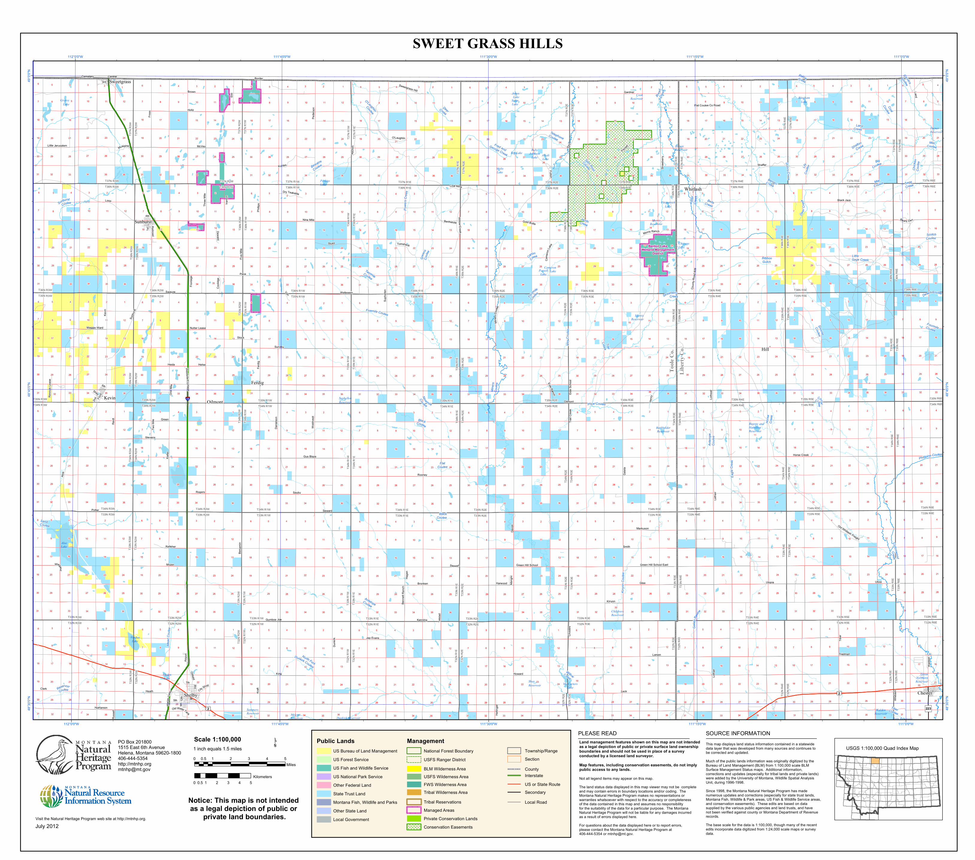
Libe
rty Co
.To
ole Co
.
TurnerReservoir
JonesLake Cook
ReservoirSwanLake
BinghamLake
FitzpatrickLake
MorrisReservoir
PerkinsLake
BrownReservoirRuby
JohnsonLake
Big Lake AlkaliLake
Dunkirk Reservoir
Mc CartersLake
ShayReservoir
SummersReservoir Melcott
Reservoir
ChildrersReservoir
SuphellenReservoir
BerkholderReservoir
MorrisReservoir
CameronLakeParsell
Lake
ChicagoLake
MoltzLake
Potts Reservoir
WaldenReservoir
VerdenLake
VirdenLake
GreatNorthernReservoir
AloeLake
Bourpe andHamiltonReservoir
GrassyLake
7th
Gus Blaze
Mar ia
s Valle
y
Central
6th
3rd
1st
Holtz
City Shop
Horse Creek
Parsell
2nd
Railr oad
Kevin
Henry
Berthelote
Black Jack
Glee
Mine
rs Co
ulee
Wan
ken
Sweetgrass Hill
Swayze
Oilf ield
Howard
Fey
Coal Mine
Sundby
McAlpine
Rooney
McVey
Front
Wiegand
Hage
n
Shay
Kraft
Came
ron La
ke
Bronken
Potter
Eide Ranch
9th
4th
Coun
t y Ro
ad 40
9
Stevens
Oilmont
Gold Butte
Stock
O'Laughlin
5th
Little Jerusalem
Old Whitlash Freight
Gardner
Danie
lson
Latha
ir
Hill
Old Water Tank
12th
Flat Coulee Co Road
Tiber
Fu lton
Markuson
Benn
ett Ra
nch
Smith
Airpo
rt
Ben ja
min
Hesla
Dewal d
Loop
Kohles
Nine Mile
Devo
n
Ferdi
g
Two M
ile
Pace
Kinyon
Harwood
Morris Ranch
Rimroc
k Lea
se
Green Hill School East
Wil low Cr eek
Utoia
Three
Mile
Telst
ad
Hellin
ger
Hjartarson
Suph
ellen
Shaffer
Clark
Seward
Maggie Ward
Laird
Kanning
Five M
ile
Heath
Trail C
reek
Thielman
One M
ile
Van
Wold
tvedt
Lotha
ir
Brown
Pede
r son
E hli
Sauby
Albrig
ht
Aloe
Russ
ell
BorderCemetary
Sunb
urst
Utopia
Rogers
Fross
Loths
air
Kelleher
Child
ers
Nutter Lease
Iv erso
n
Dunk
irk
Helsa
Eide S
choo
l
King
Stewart
Green
Westsi de F ro nta ge
Wallewein
Larsen
Leck
Gumboe JoeGa
lata
Phil lip
s
Cooli
dge
Reidt
Mozer
Asch
im
Whit
lash
Bears Den
Tomsheck
Dry Teakettle
Stoltz
Straw
berry
Fron
tage
Jap Evans
Kief er
Green Hill School
T37N
R 3W
T 37N
R2W
T37N R3WT36N R3W
T37N
R2W
T37N
R1W
T37N R2WT36N R2W
T37N
R1W
T37N
R1E
T37N R1WT36N R1W
T37N
R1E
T37N
R2E
T37N R1ET36N R1E
T37N
R2E
T37N
R3E
T37N R2ET36N R2E
T37N
R3E
T37N
R4E
T37N R3ET36N R3E
T37N
R4E
T37N
R5E
T37N R4ET36N R4E
T37N
R5E
T37N
R6E
T37N R5ET36N R5E
T37N R6ET36N R6E
T36N
R3W
T36N
R2W
T36N R3WT35N R3W
T36N
R2W
T36N
R1W
T36N R2WT35N R2W
T36N
R1W
T36N
R1E
T36N R1WT35N R1W
T36N
R 1E
T36 N
R2E
T36N R1ET35N R1E
T36N
R2E
T36N
R3E
T36N R2ET35N R2E
T36N
R3E
T36N
R4E
T36N R3ET35N R3E
T36N
R4E
T36N
R5E
T36N R4ET35N R4E
T36N
R5E
T36N
R6E
T36N R5ET35N R5E
T36N R6ET35N R6E
T35 N
R3W
T35N
R2W
T35N R3WT34N R3W
T35 N
R2W
T35N
R1W
T35N R2WT34N R2W
T35N
R1W
T35N
R1E
T35N R1WT34N R1W
T35N
R1E
T35N
R2E
T35N R1ET34N R1E
T35N
R2E
T35N
R3E
T35N R2ET34N R2E
T35N
R3E
T35N
R4E
T35N R3ET34N R3E
T35N
R4E
T35N
R5E
T35N R4ET34N R4E
T35N
R5E
T35N
R6E
T35N R5ET34N R5E
T35N R6ET34N R6E
T34N
R3W
T34N
R2W
T34N R3WT33N R3W
T34N
R2W
T34 N
R1W
T34N R2WT33N R2W
T34N
R1W
T34N
R1E
T34N R1WT33N R1W
T34N
R1E
T34N
R2E
T34N R1ET33N R1E
T34N
R2E
T34N
R3E
T34N R2ET33N R2E
T34N
R3E
T34N
R4E
T34N R3ET33N R3E
T34N
R4E
T34N
R5E
T34N R4ET33N R4E
T34N
R5E
T34N
R6E
T34N R5ET33N R5E
T34N R6ET33N R6E
T33N
R3W
T33N
R2W
T33N R3WT32N R3W
T33N
R2W
T33N
R1W
T33N R2WT32N R2W
T33N
R1W
T33N
R1E
T33N R1WT32N R1W
T33 N
R1E
T33N
R2E
T33N R1ET32N R1E
T33N
R2E
T33N
R3E
T33N R2ET32N R2E
T33N
R3E
T33N
R4E
T33N R3ET32N R3E
T33N
R4E
T33N
R5E
T33N R4ET32N R4E
T33N
R5E
T33N
R6E
T33N R5ET32N R5E
T33N R6ET32N R6E
T32N
R3W
T32N
R2W
T32N
R2W
T32N
R1W
T32N
R1W
T32N
R1E
T32N
R1E
T32N
R2E
T32N
R2E
T32N
R3E
T32N
R3E
T32N
R4E
T32N
R4E
T32N
R5E T3
2N R5
ET3
2N R6
E
Benton LakeWetland Management
District
Chester
Kevin
Shelby
Sunburst
Ferdig
Hill
Oilmont
Sweetgrass
Whitlash
Carvers
Coulee
Deer C
reek
Telephone Coulee
Desert Coulee
Fourmile Coulee
Sand Coulee
Mac Coulee
Sam Ross
Coulee
Fred and George Creek
Tiber Coulee
Price Coulee
Little Sage Creek
Flat Coulee
Breed
Creek
Phillipine Coulee
Ribbon Gulch
Kelle
r Cr
eek
Deer Creek
Mac Coulee
Duce Cr eek
Mead
Coule
e Gala t
a Ravi
ne
Fou
rmile
Coulee
Bengor Creek
Coal
Coulee
Horse
Cree
k
North Creek
O'Laughlin
Coulee
Twomile Coulee
Stratton Creek
Lily Co
ulee
Kinyo
n Cou
le e
Belle Creek
Eagle
Cre e
k
Black Coulee
Big Coulee
Canon
Creek
Cottonwood Creek
Chick
en Co
ulee
Snoose Coulee
Scotch Coulee
Hay C
o ulee
Gree
ns Co
ulee
Black Coulee
Laird Creek
Police Creek
Antel
ope
Coule
e
Antelope Coulee
Ninemile
Coulee
Reservoir Coulee
Strawberry Creek
Powe
rs Cr
eek
Beaupre
Coulee
Fivemile Coulee
Dohrs Cre ek
North Fork Dunkirk Coulee
Sunburst Coulee
Willow Creek
Sage Creek
Corral Creek
Mine
rs C o
ulee
Trail Creek
")223£¤2
£¤2
§̈¦15
111°0'0"W
111°0'0"W
111°15'0"W
111°15'0"W
111°30'0"W
111°30'0"W
111°45'0"W
111°45'0"W
112°0'0"W
112°0'0"W
49°0'
0"N
49°0'
0"N
48°45
'0"N
48°45
'0"N
48°30
'0"N
48°30
'0"N
July 2012
PO Box 2018001515 East 6th AvenueHelena, Montana 59620-1800406-444-5354http://[email protected]
SWEET GRASS HILLS
Notice: This map is not intended as a legal depiction of public or
private land boundaries.
0 1 2 3 4 50.5Miles
0 1 2 3 4 50.5Kilometers
Scale 1:100,0001 inch equals 1.5 miles ¹ USGS 1:100,000 Quad Index MapThis map displays land status information contained in a statewide
data layer that was developed from many sources and continues tobe corrected and updated.Much of the public lands information was originally digitized by theBureau of Land Management (BLM) from 1:100,000 scale BLMSurface Management Status maps. Additional information,corrections and updates (especially for tribal lands and private lands)were added by the University of Montana, Wildlife Spatial AnalysisUnit, during 1996-1998.Since 1998, the Montana Natural Heritage Program has madenumerous updates and corrections (especially for state trust lands,Montana Fish, Wildlife & Park areas, US Fish & Wildlife Service areas,and conservation easements). These edits are based on datasupplied by the various public agencies and land trusts, and havenot been verified against county or Montana Department of Revenuerecords.The base scale for the data is 1:100,000, though many of the recentedits incorporate data digitized from 1:24,000 scale maps or surveydata.
SOURCE INFORMATION
Not all legend items may appear on this map.The land status data displayed in this map viewer may not be completeand may contain errors in boundary locations and/or coding. TheMontana Natural Heritage Program makes no representations or warranties whatsoever with respect to the accuracy or completeness of the data contained in this map and assumes no responsibility for the suitability of the data for a particular purpose. The MontanaNatural Heritage Program will not be liable for any damages incurredas a result of errors displayed here.For questions about the data displayed here or to report errors,please contact the Montana Natural Heritage Program at406-444-5354 or [email protected].
PLEASE READLand management features shown on this map are not intendedas a legal depiction of public or private surface land ownershipboundaries and should not be used in place of a surveyconducted by a licensed land surveyor.Map features, including conservation easements, do not imply public access to any lands.
Visit the Natural Heritage Program web site at http://mtnhp.org.
InterstateUS or State RouteSecondary
Township/Range
County
Local Road
Section
Management
Tribal Reservations
National Forest BoundaryUSFS Ranger District
Managed AreasPrivate Conservation LandsConservation Easements
BLM Wilderness AreaUSFS Wilderness AreaFWS Wilderness AreaTribal Wilderness Area
Public LandsUS Bureau of Land ManagementUS Forest ServiceUS Fish and Wildlife ServiceUS National Park ServiceOther Federal LandState Trust LandMontana Fish, Wildlife and ParksOther State LandLocal Government

![“d’Akker zal het sweet vergelden, Ploeg en arbey met gedult ...20140208] Koningshoeven Natuur.pdfNaspeuringen van Paul Theelen: Natuurherstel in de Peel “d’Akker zal het sweet](https://static.fdocuments.nl/doc/165x107/60435fc8f3f4f97c0574e272/aoedaakker-zal-het-sweet-vergelden-ploeg-en-arbey-met-gedult-20140208-koningshoeven.jpg)