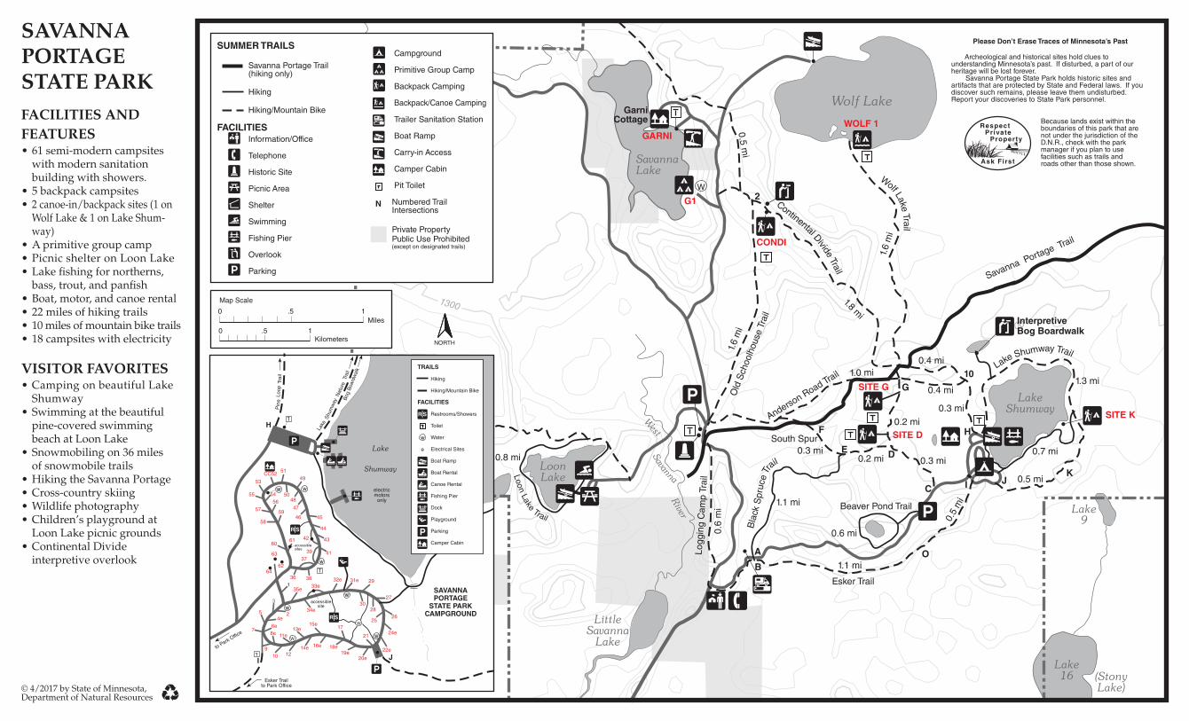
savanna portage state park summer map
2
1300 1300 2 10 H D C E O B A K J I G F 1.6 mi 1.8 mi 0.4 mi 1.6 mi 1.0 mi 0.2 mi 0.3 mi 0.6 mi 0.5 mi 1.1 mi 0.5 mi 0.7 mi 1.3 mi 1.1 mi 0.6 mi 0.4 mi 0.3 mi 0.8 mi Savanna Portage Trail 0.5 mi Old Schoolhouse Trail Anderson Road Trail Logging Camp Trail Blac k S p r u c e T r a i l Beaver Pond Trail Esker Trail L a k e S hu m w a y T r a il W o l f L a k e T r a i l C ontin e n t a l D iv i d e T r a il L o o n L a k e T r ail South Spur 0.3 mi 0.2 mi W Interpretive Bog Boardwalk SITE K SITE G SITE D CONDI WOLF 1 Please Don’t Erase Traces of Minnesota’s Past Archeological and historical sites hold clues to understanding Minnesota’s past. If disturbed, a part of our heritage will be lost forever. Savanna Portage State Park holds historic sites and artifacts that are protected by State and Federal laws. If you discover such remains, please leave them undisturbed. Report your discoveries to State Park personnel. Lake 9 G1 GARNI © 4/2017 by State of Minnesota, Department of Natural Resources Garni Cottage SUMMER TRAILS Savanna Portage Trail (hiking only) Hiking Hiking/Mountain Bike FACILITIES Information/Office Telephone Historic Site Picnic Area Shelter Swimming Fishing Pier Overlook Parking Campground Primitive Group Camp Backpack Camping Backpack/Canoe Camping Trailer Sanitation Station Boat Ramp Carry-in Access Camper Cabin Pit Toilet Numbered Trail Intersections Private Property Public Use Prohibited (except on designated trails) N SAVANNA PORTAGE STATE PARK FACILITIES AND FEATURES • 61 semi-modern campsites with modern sanitation building with showers. • 5 backpack campsites • 2 canoe-in/backpack sites (1 on Wolf Lake & 1 on Lake Shum- way) • A primitive group camp • Picnic shelter on Loon Lake • Lake fishing for northerns, bass, trout, and panfish • Boat, motor, and canoe rental • 22 miles of hiking trails • 10 miles of mountain bike trails • 18 campsites with electricity VISITOR FAVORITES • Camping on beautiful Lake Shumway • Swimming at the beautiful pine-covered swimming beach at Loon Lake • Snowmobiling on 36 miles of snowmobile trails • Hiking the Savanna Portage • Cross-country skiing • Wildlife photography • Children’s playground at Loon Lake picnic grounds • Continental Divide interpretive overlook NORTH Map Scale 0 .5 1 Kilometers 0 .5 1 Miles Because lands exist within the boundaries of this park that are not under the jurisdiction of the D.N.R., check with the park manager if you plan to use facilities such as trails and roads other than those shown. 22e H I J electric motors only Trail Nature Shumway Lake Pine Loop Trail 31e 32e 29 30 33e 27 28 25 26 24e 21 20e 34e 15e 17 12 14e 16e 18e 19e 3 5 2 7 9 10 4e 6e 8e 11e 13e 60 63 62 64 1 35e 51 53 55 57 58 59 56 54 50 49 48 46 47 61 44 43 45 39 42 37 41 36 38 to Park Office Esker Trail to Park Office accessible sites accessible site SAVANNA PORTAGE STATE PARK CAMPGROUND Bog Boardwalk CC52 TRAILS Hiking Hiking/Mountain Bike FACILITIES Restrooms/Showers Toilet Water Electrical Sites Boat Ramp Boat Rental Canoe Rental Fishing Pier Dock Playground Parking Camper Cabin e
Transcript of savanna portage state park summer map
1300
1300
2
10
H
D
C
E
OB
A
KJI
G
F
1.6
mi
1.8 mi
0.4 mi
1.6
mi
1.0 mi
0.2 mi 0.3 mi
0.6 mi
0.5
mi
1.1 mi
0.5 mi
0.7 mi
1.3 mi
1.1 mi
0.6
mi
0.4 mi
0.3 mi 1.5 mi
0.8 mi
Savanna Portage Trail
0.5 mi
Remote Lake TrailO
ld S
choo
lhou
se T
rail
Anderson Road Trail
Logg
ing
Cam
p Tr
ail
Bla
ck S
pruc
e Tr
ail
Beaver Pond Trail
Esker Trail
Lake Shumway Trail
Wolf Lake Trail
Continental Divide Trail
Loon Lake Trail
South Spur0.3 mi
0.2 mi
W
InterpretiveBog Boardwalk
SITE K
SITE G
SITE D
CONDI
WOLF 1
Please Don’t Erase Traces of Minnesota’s Past
Archeological and historical sites hold clues to understanding Minnesota’s past. If disturbed, a part of our heritage will be lost forever. Savanna Portage State Park holds historic sites and artifacts that are protected by State and Federal laws. If you discover such remains, please leave them undisturbed. Report your discoveries to State Park personnel.
Lake9
G1
GARNI
© 4/2017 by State of Minnesota, Department of Natural Resources
GarniCottage
SUMMER TRAILS
Savanna Portage Trail (hiking only)
Hiking
Hiking/Mountain Bike FACILITIES
Information/Office
Telephone
Historic Site Picnic Area
Shelter
Swimming Fishing Pier
Overlook
Parking
Campground
Primitive Group Camp
Backpack Camping Backpack/Canoe Camping
Trailer Sanitation Station
Boat Ramp
Carry-in Access
Camper Cabin
Pit Toilet Numbered Trail Intersections
Private Property Public Use Prohibited (except on designated trails)
N
SAVANNA PORTAGE STATE PARKFACILITIES ANDFEATURES• 61 semi-modern campsites
with modern sanitation building with showers.
• 5 backpack campsites• 2 canoe-in/backpack sites (1 on
Wolf Lake & 1 on Lake Shum-way)
• A primitive group camp• Picnic shelter on Loon Lake• Lake �shing for northerns,
bass, trout, and pan�sh• Boat, motor, and canoe rental• 22 miles of hiking trails• 10 miles of mountain bike trails• 18 campsites with electricity
VISITOR FAVORITES• Camping on beautiful Lake
Shumway • Swimming at the beautiful
pine-covered swimming beach at Loon Lake
• Snowmobiling on 36 miles of snowmobile trails• Hiking the Savanna Portage• Cross-country skiing• Wildlife photography• Children’s playground at
Loon Lake picnic grounds• Continental Divide interpretive overlook
NORTH
Map Scale
0 .5 1Kilometers
0 .5 1 Miles
Because lands exist within the boundaries of this park that are not under the jurisdiction of the D.N.R., check with the park manager if you plan to use facilities such as trails and roads other than those shown.
22e
H
I J
electric motors
only
Trai
l
Nat
ure
Shu
mw
ay
Lake
Pin
eLo
opTr
ail
31e32e 29
30
33e
27
28
2526
24e21
20e
34e
15e17
1214e 16e 18e
19e
3
5 2
7
910
4e6e8e 11e
13e
60
63
6264
135e
51
53
55
57
58
59
56
54 50
49
48
46
47
61
44
43
45
39
42
3741
36 38
to Park Office
Esker Trailto Park Office
accessible sites
accessible site
SAVANNA PORTAGE
STATE PARK CAMPGROUND
Bog
Boa
rdw
alk
CC52
TRAILS
Hiking
Hiking/Mountain Bike
FACILITIES
Restrooms/Showers
Toilet
Water
Electrical Sites
Boat Ramp
Boat Rental
Canoe Rental
Fishing Pier
Dock
Playground
Parking
Camper Cabin
e
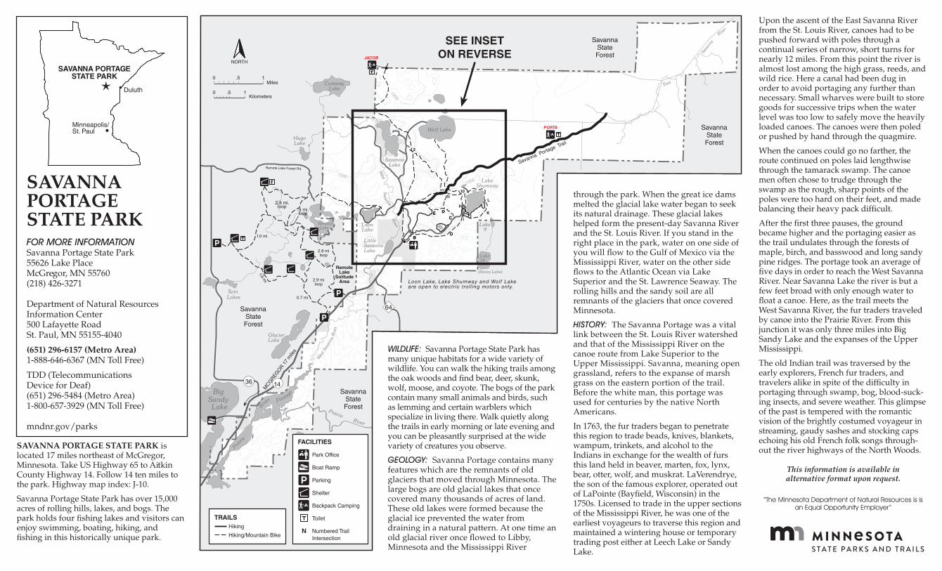
SAVANNA PORTAGE STATE PARK is located 17 miles northeast of McGregor, Minnesota. Take US Highway 65 to Aitkin County Highway 14. Follow 14 ten miles to the park. Highway map index: J-10.
Savanna Portage State Park has over 15,000 acres of rolling hills, lakes, and bogs. The park holds four �shing lakes and visitors can enjoy swimming, boating, hiking, and �shing in this historically unique park.
WILDLIFE: Savanna Portage State Park has many unique habitats for a wide variety of wildlife. You can walk the hiking trails among the oak woods and �nd bear, deer, skunk, wolf, moose, and coyote. The bogs of the park contain many small animals and birds, such as lemming and certain warblers which specialize in living there. Walk quietly along the trails in early morning or late evening and you can be pleasantly surprised at the wide variety of creatures you observe.
GEOLOGY: Savanna Portage contains many features which are the remnants of old glaciers that moved through Minnesota. The large bogs are old glacial lakes that once covered many thousands of acres of land. These old lakes were formed because the glacial ice prevented the water from draining in a natural pattern. At one time an old glacial river once �owed to Libby, Minnesota and the Mississippi River
through the park. When the great ice dams melted the glacial lake water began to seek its natural drainage. These glacial lakes helped form the present-day Savanna River and the St. Louis River. If you stand in the right place in the park, water on one side of you will �ow to the Gulf of Mexico via the Mississippi River, water on the other side �ows to the Atlantic Ocean via Lake Superior and the St. Lawrence Seaway. The rolling hills and the sandy soil are all remnants of the glaciers that once covered Minnesota.
HISTORY: The Savanna Portage was a vital link between the St. Louis River watershed and that of the Mississippi River on the canoe route from Lake Superior to the Upper Mississippi. Savanna, meaning open grassland, refers to the expanse of marsh grass on the eastern portion of the trail. Before the white man, this portage was used for centuries by the native North Americans.
In 1763, the fur traders began to penetrate this region to trade beads, knives, blankets, wampum, trinkets, and alcohol to the Indians in exchange for the wealth of furs this land held in beaver, marten, fox, lynx, bear, otter, wolf, and muskrat. LaVerendrye, the son of the famous explorer, operated out of LaPointe (Bay�eld, Wisconsin) in the 1750s. Licensed to trade in the upper sections of the Mississippi River, he was one of the earliest voyageurs to traverse this region and maintained a wintering house or temporary trading post either at Leech Lake or Sandy Lake.
Upon the ascent of the East Savanna River from the St. Louis River, canoes had to be pushed forward with poles through a continual series of narrow, short turns for nearly 12 miles. From this point the river is almost lost among the high grass, reeds, and wild rice. Here a canal had been dug in order to avoid portaging any further than necessary. Small wharves were built to store goods for successive trips when the water level was too low to safely move the heavily loaded canoes. The canoes were then poled or pushed by hand through the quagmire.
When the canoes could go no farther, the route continued on poles laid lengthwise through the tamarack swamp. The canoe men often chose to trudge through the swamp as the rough, sharp points of the poles were too hard on their feet, and made balancing their heavy pack dif�cult.
After the �rst three pauses, the ground became higher and the portaging easier as the trail undulates through the forests of maple, birch, and basswood and long sandy pine ridges. The portage took an average of �ve days in order to reach the West Savanna River. Near Savanna Lake the river is but a few feet broad with only enough water to �oat a canoe. Here, as the trail meets the West Savanna River, the fur traders traveled by canoe into the Prairie River. From this junction it was only three miles into Big Sandy Lake and the expanses of the Upper Mississippi.
The old Indian trail was traversed by the early explorers, French fur traders, and travelers alike in spite of the dif�culty in portaging through swamp, bog, blood-suck-ing insects, and severe weather. This glimpse of the past is tempered with the romantic vision of the brightly costumed voyageur in streaming, gaudy sashes and stocking caps echoing his old French folk songs through-out the river highways of the North Woods.
This information is available inalternative format upon request.
“The Minnesota Department of Natural Resources is is an Equal Opportunity Employer”
SAVANNA PORTAGE STATE PARKFOR MORE INFORMATIONSavanna Portage State Park55626 Lake PlaceMcGregor, MN 55760(218) 426-3271 Department of Natural ResourcesInformation Center500 Lafayette RoadSt. Paul, MN 55155-4040
(651) 296-6157 (Metro Area)1-888-646-6367 (MN Toll Free)
TDD (Telecommunications Device for Deaf)(651) 296-5484 (Metro Area) 1-800-657-3929 (MN Toll Free)
mndnr.gov/parks
13001300
1300
MCG
REGO
R 17
mile
s
64
1436
Remote Lake Forest Rd.
2
10
H
C
G
E D
OB
A
JIC
E D
OB
K
L2.8 mi.loop
.9 mi.loop
1.0 mi
1.9 mi
2.8 miloop
2.9 miloop
0.7 mi
Loon Lake, Lake Shumway and Wolf Lake are open to electric troll ing motors only.
Savanna Portage Trail
JACOB
PORTA
RemoteLake
SolitudeArea
SavannaState Forest
SavannaState Forest
SavannaState Forest
SavannaState Forest
SEE INSETON REVERSE
0 .5 1 Miles
Kilometers0 .5 1
NORTH
TRAILS Hiking
Hiking/Mountain BikeN
FACILITIES
Park Office
Boat Ramp
Parking
Shelter
Backpack Camping
Toilet
Numbered Trail Intersection
SAVANNA PORTAGE STATE PARK
Duluth•
Minneapolis/St. Paul •