Paléo-Meetic–Cap Canaille (F)...Paléo-Meetic–Cap Canaille (F) M u l t i -p i t c h c l i m b i...
4
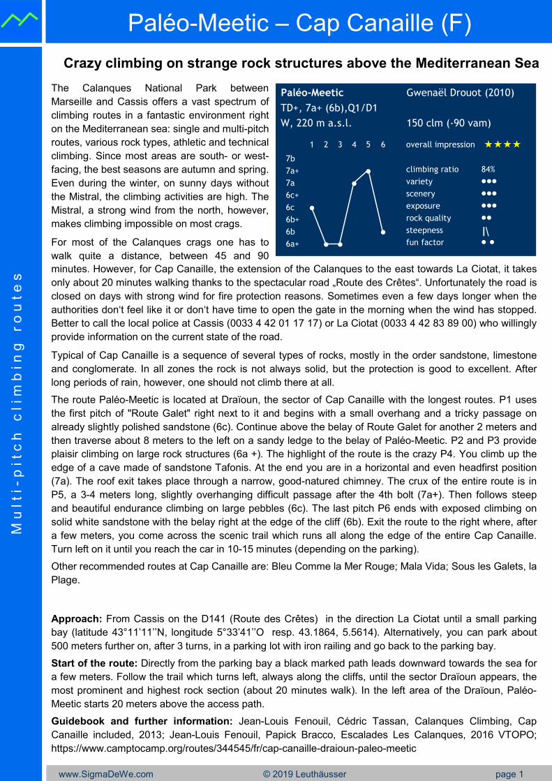
www.SigmaDeWe.com © 2019 Leuthäusser page 1 Paléo-Meetic – Cap Canaille (F) M u l t i - p i t c h c l i m b i n g r o u t e s Crazy climbing on strange rock structures above the Mediterranean Sea minutes. However, for Cap Canaille, the extension of the Calanques to the east towards La Ciotat, it takes only about 20 minutes walking thanks to the spectacular road „Route des Crêtes“. Unfortunately the road is closed on days with strong wind for fire protection reasons. Sometimes even a few days longer when the authorities don‘t feel like it or don‘t have time to open the gate in the morning when the wind has stopped. Better to call the local police at Cassis (0033 4 42 01 17 17) or La Ciotat (0033 4 42 83 89 00) who willingly provide information on the current state of the road. Typical of Cap Canaille is a sequence of several types of rocks, mostly in the order sandstone, limestone and conglomerate. In all zones the rock is not always solid, but the protection is good to excellent. After long periods of rain, however, one should not climb there at all. The route Paléo-Meetic is located at Draïoun, the sector of Cap Canaille with the longest routes. P1 uses the first pitch of "Route Galet" right next to it and begins with a small overhang and a tricky passage on already slightly polished sandstone (6c). Continue above the belay of Route Galet for another 2 meters and then traverse about 8 meters to the left on a sandy ledge to the belay of Paléo-Meetic. P2 and P3 provide plaisir climbing on large rock structures (6a +). The highlight of the route is the crazy P4. You climb up the edge of a cave made of sandstone Tafonis. At the end you are in a horizontal and even headfirst position (7a). The roof exit takes place through a narrow, good-natured chimney. The crux of the entire route is in P5, a 3-4 meters long, slightly overhanging difficult passage after the 4th bolt (7a+). Then follows steep and beautiful endurance climbing on large pebbles (6c). The last pitch P6 ends with exposed climbing on solid white sandstone with the belay right at the edge of the cliff (6b). Exit the route to the right where, after a few meters, you come across the scenic trail which runs all along the edge of the entire Cap Canaille. Turn left on it until you reach the car in 10-15 minutes (depending on the parking). Other recommended routes at Cap Canaille are: Bleu Comme la Mer Rouge; Mala Vida; Sous les Galets, la Plage. Approach: From Cassis on the D141 (Route des Crêtes) in the direction La Ciotat until a small parking bay (latitude 43°11’11’’N, longitude 5°33’41’’O resp. 43.1864, 5.5614). Alternatively, you can park about 500 meters further on, after 3 turns, in a parking lot with iron railing and go back to the parking bay. Start of the route: Directly from the parking bay a black marked path leads downward towards the sea for a few meters. Follow the trail which turns left, always along the cliffs, until the sector Draïoun appears, the most prominent and highest rock section (about 20 minutes walk). In the left area of the Draïoun, Paléo- Meetic starts 20 meters above the access path. Guidebook and further information: Jean-Louis Fenouil, Cédric Tassan, Calanques Climbing, Cap Canaille included, 2013; Jean-Louis Fenouil, Papick Bracco, Escalades Les Calanques, 2016 VTOPO; https://www.camptocamp.org/routes/344545/fr/cap-canaille-draioun-paleo-meetic The Calanques National Park between Marseille and Cassis offers a vast spectrum of climbing routes in a fantastic environment right on the Mediterranean sea: single and multi-pitch routes, various rock types, athletic and technical climbing. Since most areas are south- or west- facing, the best seasons are autumn and spring. Even during the winter, on sunny days without the Mistral, the climbing activities are high. The Mistral, a strong wind from the north, however, makes climbing impossible on most crags. For most of the Calanques crags one has to walk quite a distance, between 45 and 90 Paléo-Meetic Gwenaël Drouot (2010) TD+, 7a+ (6b),Q1/D1 W, 220 m a.s.l. 150 clm (-90 vam) 1 2 3 4 5 6 overall impression 7b 7a+ ● climbing ratio 84% 7a ● variety ••• 6c+ scenery ••• 6c ● exposure ••• 6b+ rock quality •• 6b ● steepness I\ 6a+ ● ● fun factor • •
Transcript of Paléo-Meetic–Cap Canaille (F)...Paléo-Meetic–Cap Canaille (F) M u l t i -p i t c h c l i m b i...
www.SigmaDeWe.com © 2019 Leuthäusser page 1
Paléo-Meetic – Cap Canaille (F)M
u l t i -
p i t c
h c
l i m
b i n
g r
o u
t e
s
Crazy climbing on strange rock structures above the Mediterranean Sea
minutes. However, for Cap Canaille, the extension of the Calanques to the east towards La Ciotat, it takes
only about 20 minutes walking thanks to the spectacular road „Route des Crêtes“. Unfortunately the road is
closed on days with strong wind for fire protection reasons. Sometimes even a few days longer when the
authorities don‘t feel like it or don‘t have time to open the gate in the morning when the wind has stopped.
Better to call the local police at Cassis (0033 4 42 01 17 17) or La Ciotat (0033 4 42 83 89 00) who willingly
provide information on the current state of the road.
Typical of Cap Canaille is a sequence of several types of rocks, mostly in the order sandstone, limestone
and conglomerate. In all zones the rock is not always solid, but the protection is good to excellent. After
long periods of rain, however, one should not climb there at all.
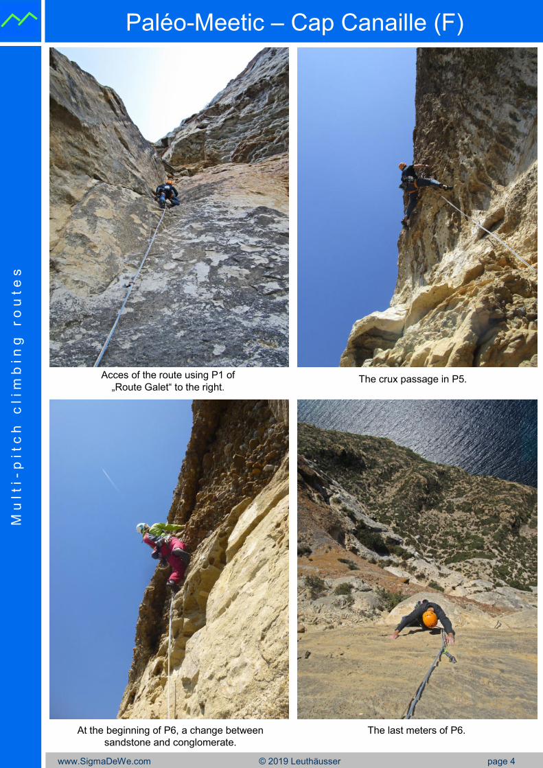
The route Paléo-Meetic is located at Draïoun, the sector of Cap Canaille with the longest routes. P1 uses
the first pitch of "Route Galet" right next to it and begins with a small overhang and a tricky passage on
already slightly polished sandstone (6c). Continue above the belay of Route Galet for another 2 meters and
then traverse about 8 meters to the left on a sandy ledge to the belay of Paléo-Meetic. P2 and P3 provide
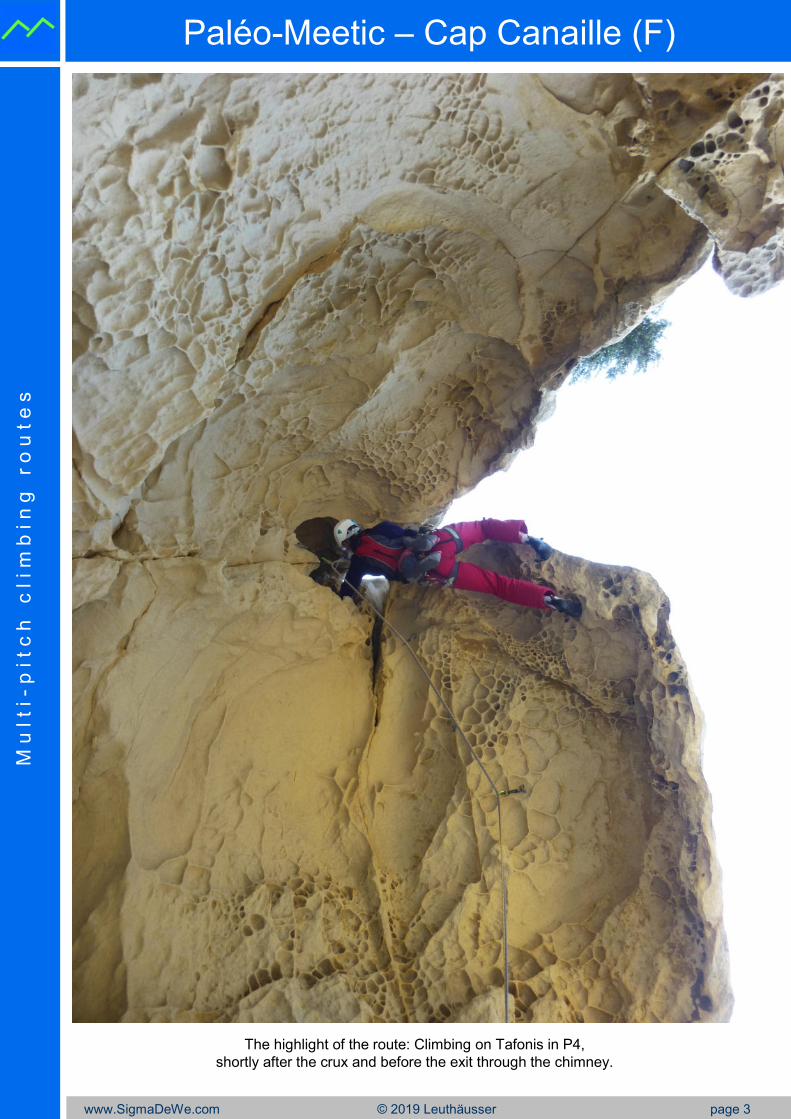
plaisir climbing on large rock structures (6a +). The highlight of the route is the crazy P4. You climb up the
edge of a cave made of sandstone Tafonis. At the end you are in a horizontal and even headfirst position
(7a). The roof exit takes place through a narrow, good-natured chimney. The crux of the entire route is in
P5, a 3-4 meters long, slightly overhanging difficult passage after the 4th bolt (7a+). Then follows steep
and beautiful endurance climbing on large pebbles (6c). The last pitch P6 ends with exposed climbing on
solid white sandstone with the belay right at the edge of the cliff (6b). Exit the route to the right where, after
a few meters, you come across the scenic trail which runs all along the edge of the entire Cap Canaille.
Turn left on it until you reach the car in 10-15 minutes (depending on the parking).
Other recommended routes at Cap Canaille are: Bleu Comme la Mer Rouge; Mala Vida; Sous les Galets, la
Plage.
Approach: From Cassis on the D141 (Route des Crêtes) in the direction La Ciotat until a small parking
bay (latitude 43°11’11’’N, longitude 5°33’41’’O resp. 43.1864, 5.5614). Alternatively, you can park about
500 meters further on, after 3 turns, in a parking lot with iron railing and go back to the parking bay.
Start of the route: Directly from the parking bay a black marked path leads downward towards the sea for
a few meters. Follow the trail which turns left, always along the cliffs, until the sector Draïoun appears, the
most prominent and highest rock section (about 20 minutes walk). In the left area of the Draïoun, Paléo-
Meetic starts 20 meters above the access path.
Guidebook and further information: Jean-Louis Fenouil, Cédric Tassan, Calanques Climbing, Cap
Canaille included, 2013; Jean-Louis Fenouil, Papick Bracco, Escalades Les Calanques, 2016 VTOPO;
https://www.camptocamp.org/routes/344545/fr/cap-canaille-draioun-paleo-meetic
The Calanques National Park between
Marseille and Cassis offers a vast spectrum of
climbing routes in a fantastic environment right
on the Mediterranean sea: single and multi-pitch
routes, various rock types, athletic and technical
climbing. Since most areas are south- or west-
facing, the best seasons are autumn and spring.
Even during the winter, on sunny days without
the Mistral, the climbing activities are high. The
Mistral, a strong wind from the north, however,
makes climbing impossible on most crags.
For most of the Calanques crags one has to
walk quite a distance, between 45 and 90
Paléo-Meetic Gwenaël Drouot (2010)
TD+, 7a+ (6b),Q1/D1
W, 220 m a.s.l. 150 clm (-90 vam)
1 2 3 4 5 6 overall impression ����
7b
7a+ ● climbing ratio 84%
7a ● variety •••
6c+ scenery •••
6c ● exposure •••
6b+ rock quality ••
6b ● steepness I\6a+ ● ● fun factor • •
www.SigmaDeWe.com © 2019 Leuthäusser page 2
Paléo-Meetic – Cap Canaille (F)M
u l t i -
p i t c
h c
l i m
b i n
g r
o u
t e
s
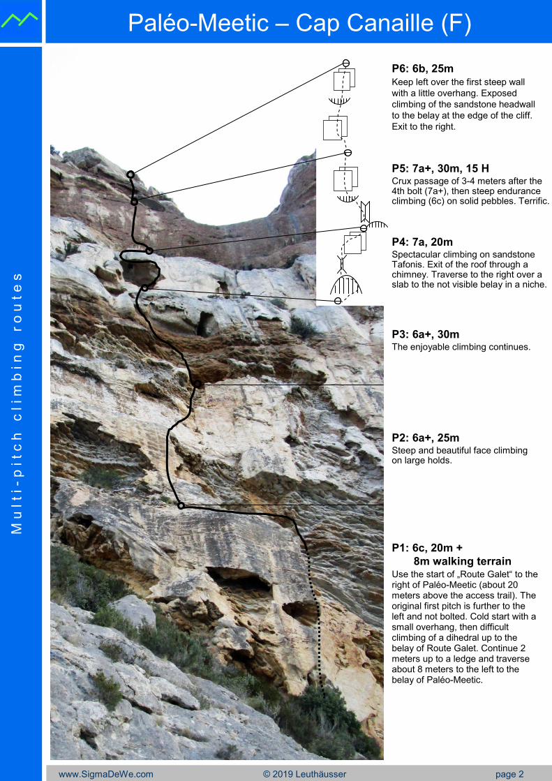
P1: 6c, 20m +
8m walking terrainUse the start of „Route Galet“ to the right of Paléo-Meetic (about 20 meters above the access trail). The original first pitch is further to the left and not bolted. Cold start with a small overhang, then difficult climbing of a dihedral up to the belay of Route Galet. Continue 2 meters up to a ledge and traverse about 8 meters to the left to the belay of Paléo-Meetic.
P3: 6a+, 30mThe enjoyable climbing continues.
P4: 7a, 20mSpectacular climbing on sandstone Tafonis. Exit of the roof through a chimney. Traverse to the right over a slab to the not visible belay in a niche.
P2: 6a+, 25mSteep and beautiful face climbing on large holds.
P5: 7a+, 30m, 15 HCrux passage of 3-4 meters after the 4th bolt (7a+), then steep endurance climbing (6c) on solid pebbles. Terrific.
P6: 6b, 25m Keep left over the first steep wall
with a little overhang. Exposed
climbing of the sandstone headwall
to the belay at the edge of the cliff.
Exit to the right.
www.SigmaDeWe.com © 2019 Leuthäusser page 3
Paléo-Meetic – Cap Canaille (F)M
u l t i -
p i t c
h c
l i m
b i n
g r
o u
t e
s
The highlight of the route: Climbing on Tafonis in P4,
shortly after the crux and before the exit through the chimney.
www.SigmaDeWe.com © 2019 Leuthäusser page 4
Paléo-Meetic – Cap Canaille (F)M
u l t i -
p i t c
h c
l i m
b i n
g r
o u
t e
s
Acces of the route using P1 of
„Route Galet“ to the right.
At the beginning of P6, a change between
sandstone and conglomerate.
The last meters of P6.
The crux passage in P5.