Josimar G. Fernandes1,2; Danielle A. Bressiani Mariana D ...Josimar G. Fernandes1,2; Danielle A....
13
Josimar G. Fernandes 1,2 ; Danielle A. Bressiani 2,3 ; Mariana D. Villas Boas 4 ; Raghavan Srinivasan 2 , Josiclêda D. Ganvíncio 5 & Maria B. G. S. Freire 6 1 Agronomic Institute of Pernambuco 2 Spatial Science Laboratory, Texas A&M University 3 Engineering School of São Carlos, University of São Paulo 4 Geological Survey of Brazil 5 Federal University of Pernambuco 6 Federal Rural University of Pernambuco 2013 International SWAT Conference Toulouse, France
Transcript of Josimar G. Fernandes1,2; Danielle A. Bressiani Mariana D ...Josimar G. Fernandes1,2; Danielle A....
Josimar G. Fernandes1,2; Danielle A. Bressiani 2,3; Mariana D. Villas Boas 4; Raghavan Srinivasan2, Josiclêda D. Ganvíncio5
& Maria B. G. S. Freire6 1 Agronomic Institute of Pernambuco
2 Spatial Science Laboratory, Texas A&M University 3 Engineering School of São Carlos, University of São Paulo
4 Geological Survey of Brazil 5 Federal University of Pernambuco
6 Federal Rural University of Pernambuco
2013 International SWAT Conference Toulouse, France

Background and Objectives SWAT is rapidly being used as a tool in many studies in Brazilian
watersheds, in different parts of the country.
Although its use has been growing in Brazil, the studies developed are still limited due to the large amount of information needed to describe the spatial and temporal variability of natural systems in contrast to the lack of detailed data.
This paper was conducted in order to identify the studies developed with SWAT in Brazil, noting their distribution by states, purposes of application of the model, identification of research groups and their publications over the years. Identifying thus the potential of the tool in the country, and also the problems encountered.
This study aims to identify, map and discuss the use of SWAT model in Brazil.
Publications applying SWAT in Brazil
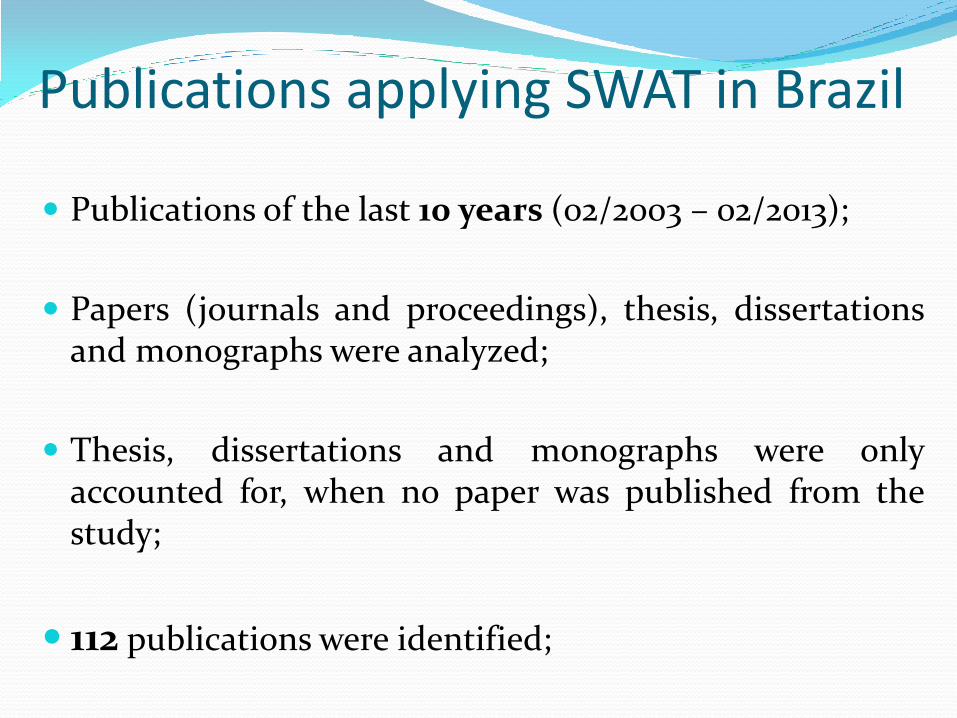
Publications of the last 10 years (02/2003 – 02/2013);
Papers (journals and proceedings), thesis, dissertations and monographs were analyzed;
Thesis, dissertations and monographs were only accounted for, when no paper was published from the study;
112 publications were identified;
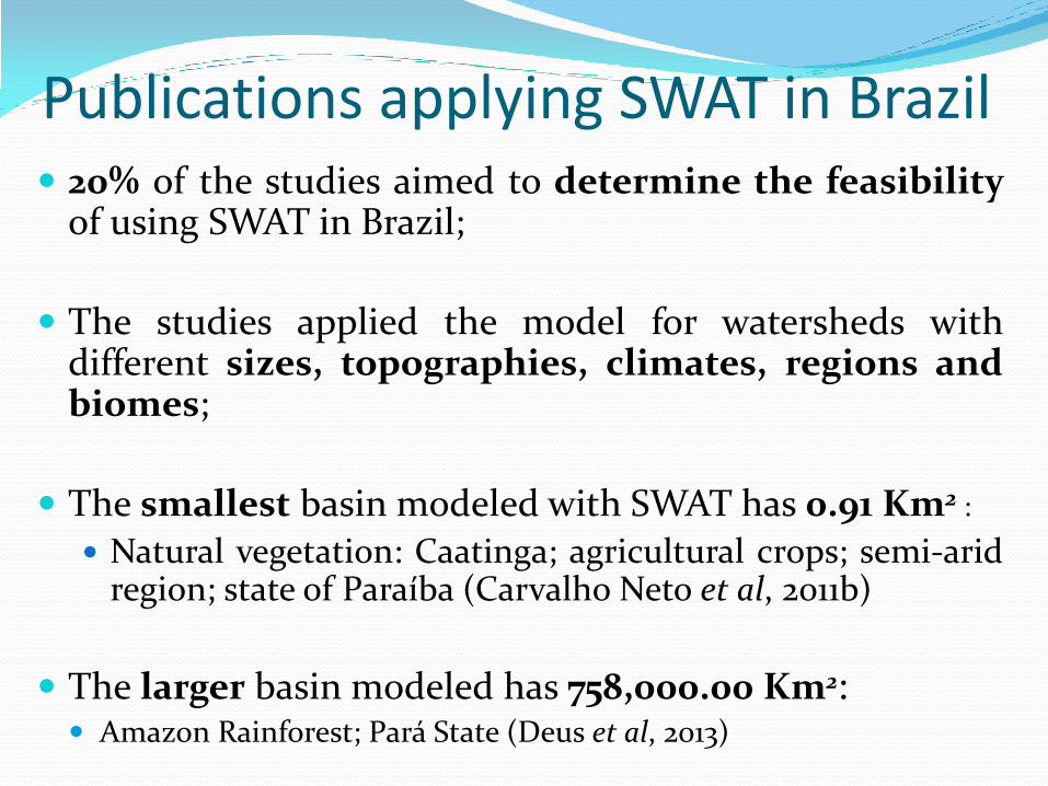
Publications applying SWAT in Brazil 20% of the studies aimed to determine the feasibility
of using SWAT in Brazil;
The studies applied the model for watersheds with different sizes, topographies, climates, regions and biomes;
The smallest basin modeled with SWAT has 0.91 Km2 :
Natural vegetation: Caatinga; agricultural crops; semi-arid region; state of Paraíba (Carvalho Neto et al, 2011b)
The larger basin modeled has 758,000.00 Km2: Amazon Rainforest; Pará State (Deus et al, 2013)
Publications applying SWAT in Brazil
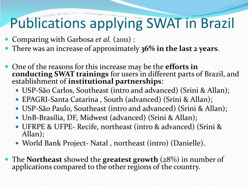
Comparing with Garbosa et al. (2011) : There was an increase of approximately 36% in the last 2 years.
One of the reasons for this increase may be the efforts in
conducting SWAT trainings for users in different parts of Brazil, and establishment of institutional partnerships: USP-São Carlos, Southeast (intro and advanced) (Srini & Allan); EPAGRI-Santa Catarina , South (advanced) (Srini & Allan); USP-São Paulo, Southeast (intro and advanced) (Srini & Allan); UnB-Brasília, DF, Midwest (advanced) (Srini & Allan); UFRPE & UFPE- Recife, northeast (intro & advanced) (Srini &
Allan); World Bank Project- Natal , northeast (intro) (Danielle).
The Northeast showed the greatest growth (28%) in number of
applications compared to the other regions of the country.
Publications applying SWAT in Brazil
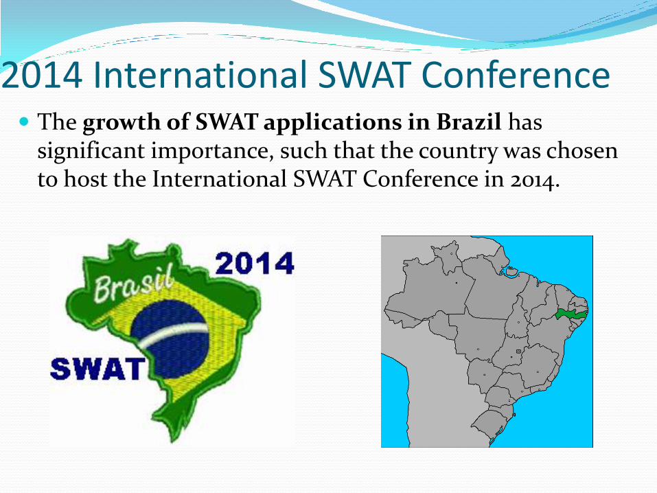
2014 International SWAT Conference The growth of SWAT applications in Brazil has
significant importance, such that the country was chosen to host the International SWAT Conference in 2014.
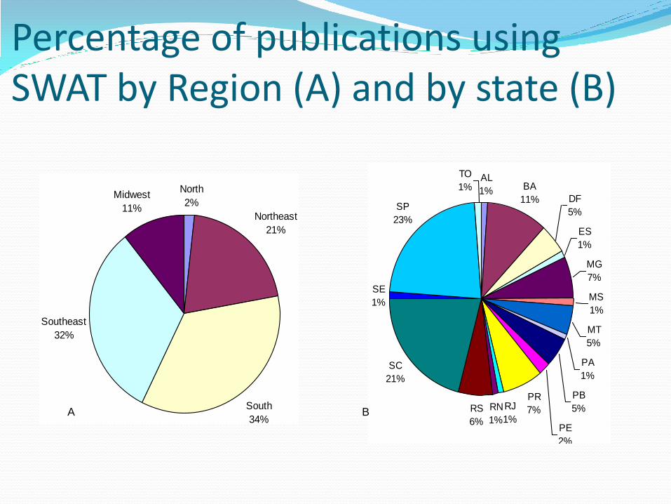
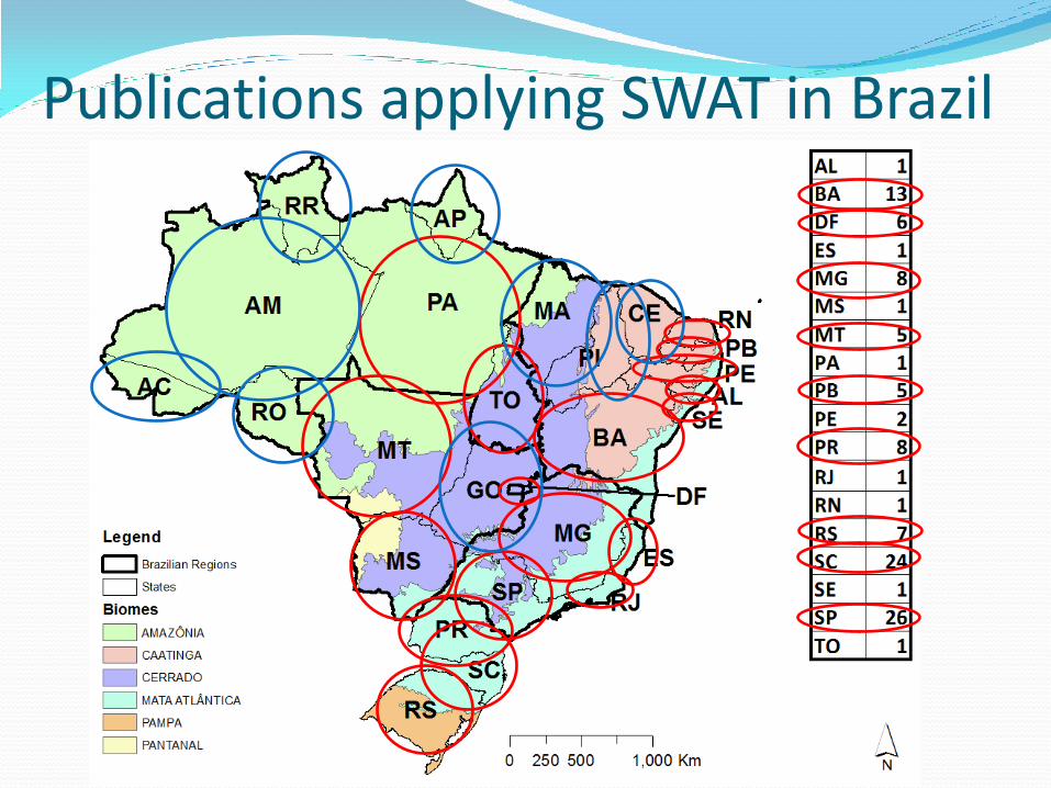
Percentage of publications using SWAT by Region (A) and by state (B)
North
2%
Northeast
21%
South
34%
Southeast
32%
Midwest
11%
AL
1% BA
11% DF
5%
ES
1%
MG
7%
MS
1%
MT
5%
PA
1%
PB
5%
PE
2%
PR
7%RS
6%
SC
21%
SE
1%
SP
23%
TO
1%
RJ
1%
RN
1%A B
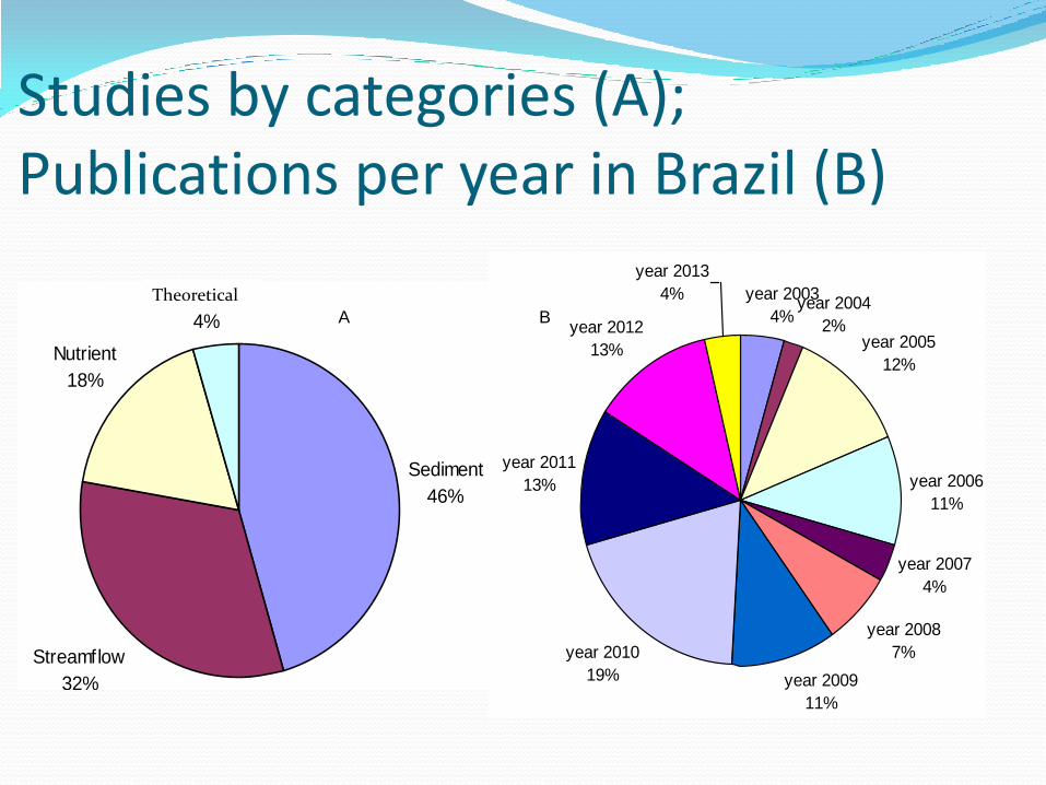
Studies by categories (A); Publications per year in Brazil (B)
Sediment
46%
Streamflow
32%
Nutrient
18%
Ditactic
4%
year 2003
4%year 2004
2%year 2005
12%
year 2006
11%
year 2007
4%
year 2008
7%
year 2009
11%
year 2010
19%
year 2011
13%
year 2012
13%
year 2013
4%
year 2003
year 2004
year 2005
year 2006
year 2007
year 2008
year 2009
year 2010
year 2011
year 2012
year 2013
A B
Theoretical
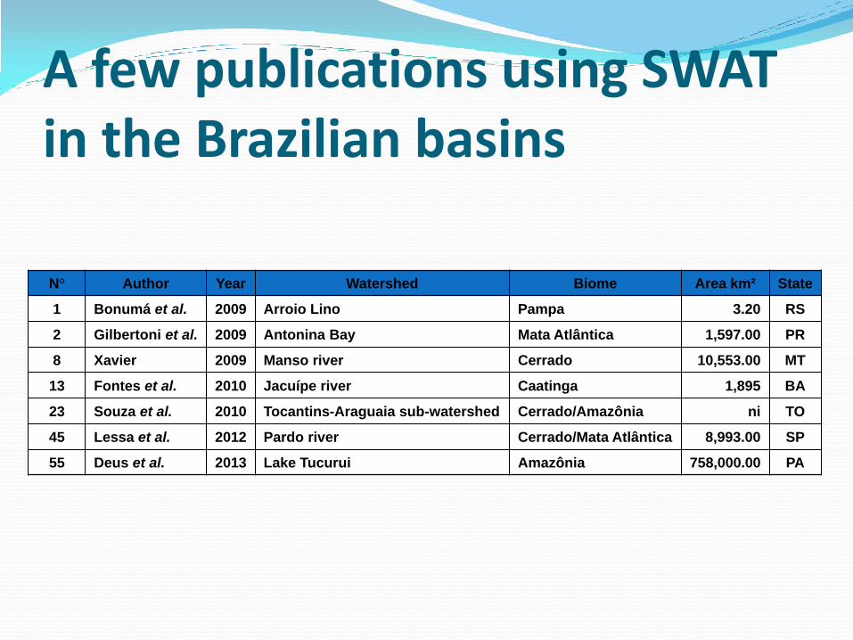
A few publications using SWAT in the Brazilian basins
N° Author Year Watershed Biome Area km² State
1 Bonumá et al. 2009 Arroio Lino Pampa 3.20 RS
2 Gilbertoni et al. 2009 Antonina Bay Mata Atlântica 1,597.00 PR
8 Xavier 2009 Manso river Cerrado 10,553.00 MT
13 Fontes et al. 2010 Jacuípe river Caatinga 1,895 BA
23 Souza et al. 2010 Tocantins-Araguaia sub-watershed Cerrado/Amazônia ni TO
45 Lessa et al. 2012 Pardo river Cerrado/Mata Atlântica 8,993.00 SP
55 Deus et al. 2013 Lake Tucurui Amazônia 758,000.00 PA
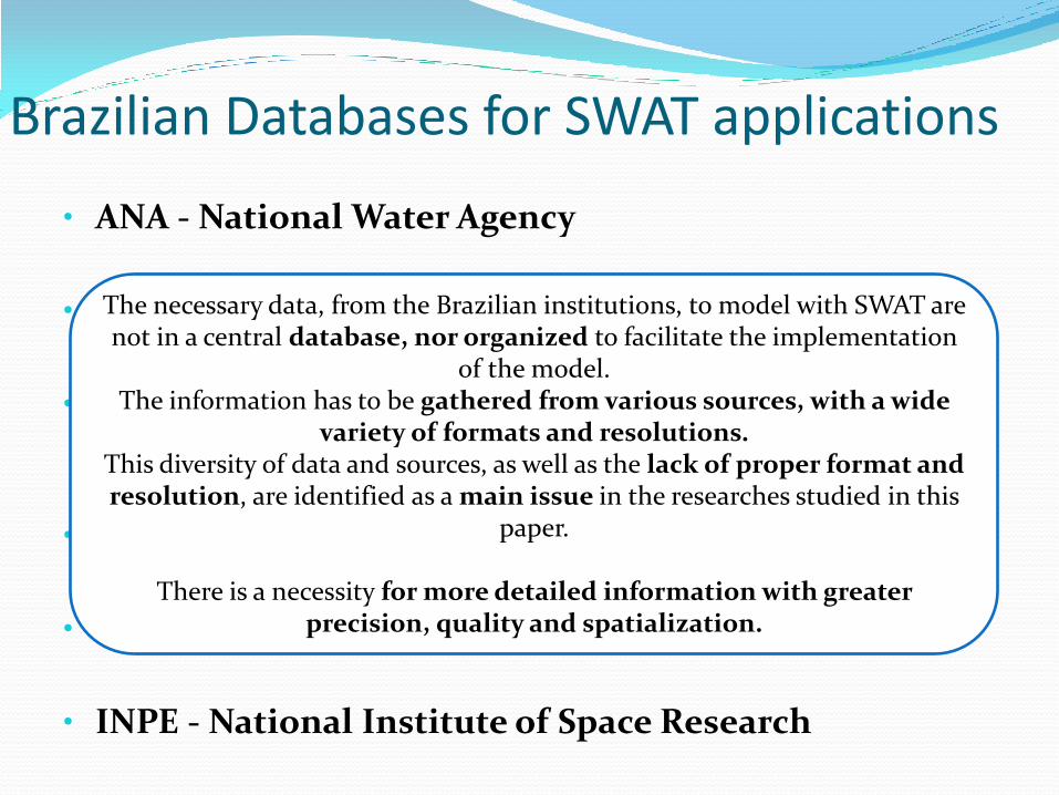
Brazilian Databases for SWAT applications
• ANA - National Water Agency
• ANEEL - National Agency of Electric Energy
• EMBRAPA - Brazilian Agricultural Research Corporation
• IBGE - Brazilian Institute of Geography and Statistics
• INMET - National Institute of Meteorology
• INPE - National Institute of Space Research
The necessary data, from the Brazilian institutions, to model with SWAT are not in a central database, nor organized to facilitate the implementation
of the model. The information has to be gathered from various sources, with a wide
variety of formats and resolutions. This diversity of data and sources, as well as the lack of proper format and resolution, are identified as a main issue in the researches studied in this
paper.
There is a necessity for more detailed information with greater precision, quality and spatialization.
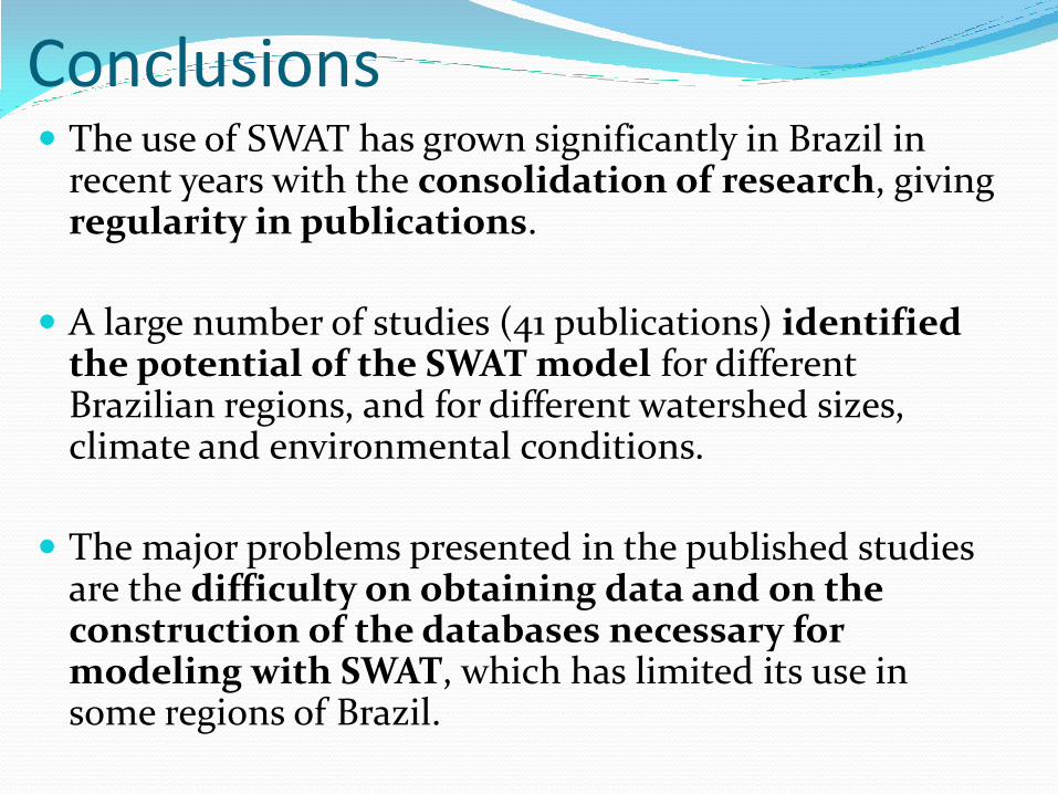
Conclusions The use of SWAT has grown significantly in Brazil in
recent years with the consolidation of research, giving regularity in publications.
A large number of studies (41 publications) identified the potential of the SWAT model for different Brazilian regions, and for different watershed sizes, climate and environmental conditions.
The major problems presented in the published studies are the difficulty on obtaining data and on the construction of the databases necessary for modeling with SWAT, which has limited its use in some regions of Brazil.
Thank you very much!
For more information:
[email protected] (Josimar G. Fernandes)
[email protected] (Danielle Bressiani)