:I · 2012-06-14 · PVC Plastic conformin9 to ASTM F480 and (ASTM D1785 or ASTM D2241): (check...
113
FROM: t14A v TO: CQMISSION ON WATER RESOURCE MANQEMENT INIT. TO: KUNIMURA. I. LEROUX, E. MILLS, D. OHYE, L. :I OHYE,M. __ OSHIRO, K. SWANSON, S. __ __ TORRES, R. UYENO, D. YODA, K. YOSHINAGA, M. INIT: SUSPENSE DATE: FOR: __ Approval Signature Information (06/08) PLEASE: See Me Review & Comment Take Action Type Draft __ Type Final File __ Xerox _ copies
Transcript of :I · 2012-06-14 · PVC Plastic conformin9 to ASTM F480 and (ASTM D1785 or ASTM D2241): (check...
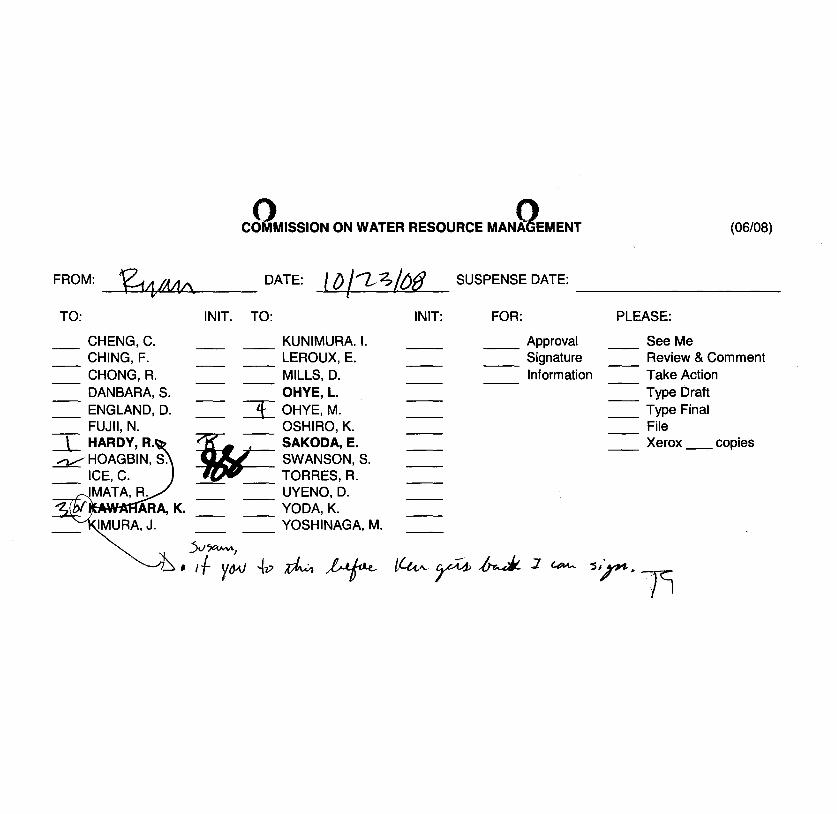
FROM: ~J1 t14A v
TO:
CQMISSION ON WATER RESOURCE MANQEMENT
INIT. TO:
KUNIMURA. I. LEROUX, E. MILLS, D. OHYE, L.
:I OHYE,M. __ OSHIRO, K.
~SAKODA'E. SWANSON, S.
__ __ TORRES, R. UYENO, D. YODA, K. YOSHINAGA, M.
INIT:
SUSPENSE DATE:
FOR:
__ Approval Signature Information
(06/08)
PLEASE:
See Me Review & Comment Take Action Type Draft
__ Type Final File
__ Xerox _ copies
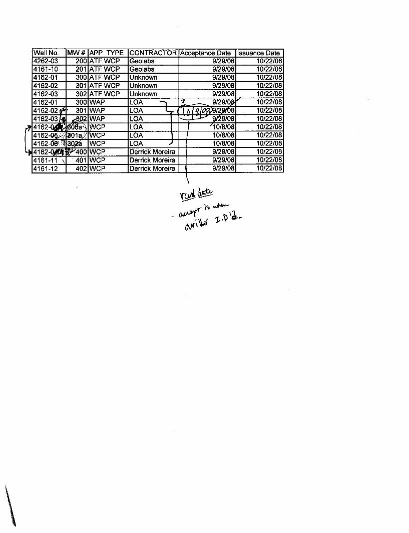
Well No. MW# APP TYPE CONTRACTOR Acceptance Date Issuance Date 4262-03 200 ATFWCP Geolabs 9/29/08 10/22/08 4161-10 201 ATFWCP Geolabs 9/29/08 10/22/08 4162-01 300 ATFWCP Unknown 9/29/08 10/22/08 4162-02 301 ATFWCP Unknown 9/29/08 10/22/08 4162-03 302 ATFWCP Unknown 9/29/08 10/22/08 4162-01 300 WAP LOA 1 '1 - 9/29/0f, 10/22/08 4162-02 0" • 301 WAP LOA L -If. I ~/~/2.9f08 10/22/08 4162-03/4 &.02- WAP LOA ....L:..J....-" e,'29/08 10/22/08
rf 4162-na~ it{(lAa'\ IWCP LOA , '10/8/08 10/22/08 4162-~; ~01al~ rWcP LOA 10/8/08 10/22/08 4162-08'· \I ~ WCP LOA .., 10/8/08 10/22/08
4 4162-014 ~;v400 WCP Derrick Moreira 9/29/08 10/22/08 4161-11 , ' 401 WCP Derrick Moreira 9/29/08 10/22/08 4161-12 402 WCP Derrick Moreira I 9/29/08 10/22/08
\
Q.~
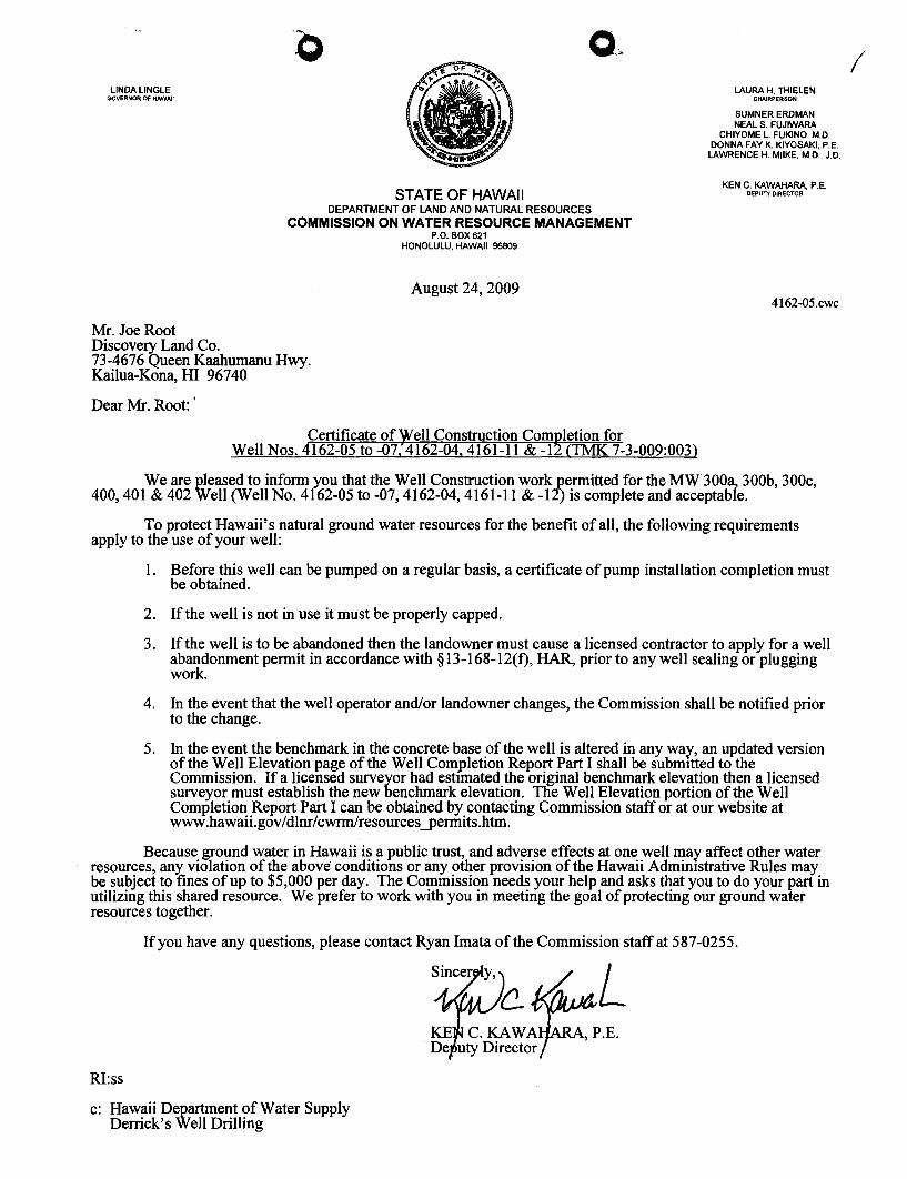
LINDA LINGLE GOVERNOR OF HAWAII
LAURA H. THIELEN CHAIRPERSON
STATE OF HAWAII DEPARTMENT OF LAND AND NATURAL RESOURCES
COMMISSION ON WATER RESOURCE MANAGEMENT P.O. BOX 621
HONOLULU, HAWAII 96809
August 24, 2009
SUMNER ERDMAN NEAL S. FUJIWARA
CHIYOME l. FUKINO, M.D. DONNA FAY K KIYOSAKI, P.E.
LAWRENCE H. MilKE, M.D., J.D.
KEN C. KAWAHARA, P.E. DEPUTY DIRECTOR
4162-05.cwc
Mr. Joe Root Discovery Land Co. 73-4676 Queen Kaahumanu Hwy. Kailua-Kona, HI 96740
Dear Mr. Root:'
Certificate of Well Construction Com~letion for Well Nos. 4162-05 to -07. 4162-04. 4161-11 & -1 aMI( 7-3-009:003)
We are pleased to inform you that the Well Construction work "permitted for the MW300a, 300b, 300c, 400,401 & 402 Well (Well No. 4162-05 to -07, 4162-04, 4161-11 & -12) is complete and acceptable.
To protect Hawaii's natural ground water resources for the benefit of all, the following requirements apply to the use of your well:
1. Before this well can be pumped on a regular basis, a certificate of pump installation completion must be obtained.
2. If the well is not in use it must be properly capped.
3. If the well is to be abandoned then the landowner must cause a licensed contractor to apply for a well abandonment permit in accordance with § 13-168-12(f), HAR, prior to any well sealing or plugging work.
4. In the event that the well operator and/or landowner changes, the Commission shall be notified prior to the change.
5. In the event the benchmark in the concrete base of the well is altered in any way, an updated version of the Well Elevation page of the Well Completion Report Part I shall be submitted to the Commission. If a licensed surveyor had estImated the original benchmark elevation then a licensed surveyor must establish the new benchmark elevation. The Well Elevation portion of the Well Completion Report Part I can be obtained by contacting Commission staff or at our website at www.hawaiLgov/dlnr/cwrmlresources-permits.htm.
Because ground water in Hawaii is a public trust, and adverse effects at one well may affect other water resources, any violation of the above conditions or any other provision of the Hawaii Admimstrative Rules may be subject to fines of up to $5,000 per day. The Commission needs your help and asks that you to do your part in utilizing this shared resource. We prefer to work with you in meeting the goal of protecting our ground water resources together.
If you have any questions, please contact Ryan Imata of the Commission staff at 587-0255.
RI:ss
c: Hawaii Department of Water Supply Derrick's Well Drilling
I
LINDA LINGLE GOVERNOR OF HAWAII
Mr. Derrick Moreira
o o
STATE OF HAWAII DEPARTMENT OF LAND AND NATURAL RESOURCES
COMMISSION ON WATER RESOURCE MANAGEMENT P.O. BOX 621
HONOLULU, HAWAII 96809
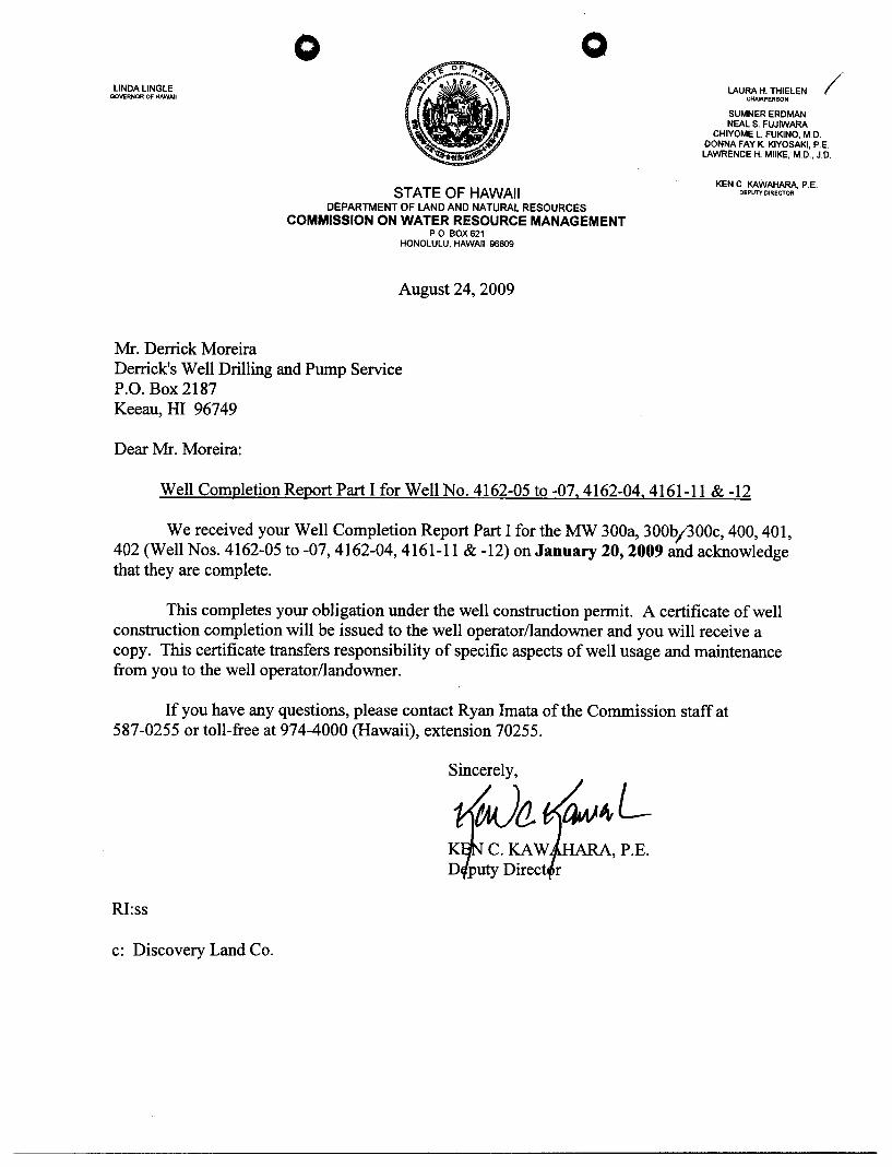
August 24, 2009
Derrick's Well Drilling and Pump Service P.O. Box 2187 Keeau, HI 96749
Dear Mr. Moreira:
LAURA H. THIELEN /' CHAIRPERSON
SUMNER ERDMAN NEAL S. FUJIWARA
CHIYOME L. FUKINO, M.D. DONNA FAY K. KIYOSAKI, P.E. LAWRENCE H. MIlKE,'M.D., J.D.
KEN C. KAWAHARA, P.E. DEPUTY DIRECTOR
Well Completion Report Part I for Well No. 4162-05 to -07, 4162-04, 4161-11 & -12
We received your Well Completion Report Part I for the MW 300a, 300b;300c, 400, 401, 402 (Well Nos. 4162-05 to -07, 4162-04, 4161-11 & -12) on January 20, 2009 and acknowledge that they are complete.
This completes your obligation under the well construction permit. A certificate of well construction completion will be issued to the well operator/landowner and you will receive a copy. This certificate transfers responsibility of specific aspects of well usage and maintenance from you to the well operator/landowner.
If you have any questions, please contact Ryan Imata of the Commission staff at 587-0255 or toll-free at 974-4000 (Hawaii), extension 70255.
Sincerely,
fJa. RA, P.E.
RI:ss
c: Discovery Land Co.
o
o o
o o

o o
o o

o o
Results
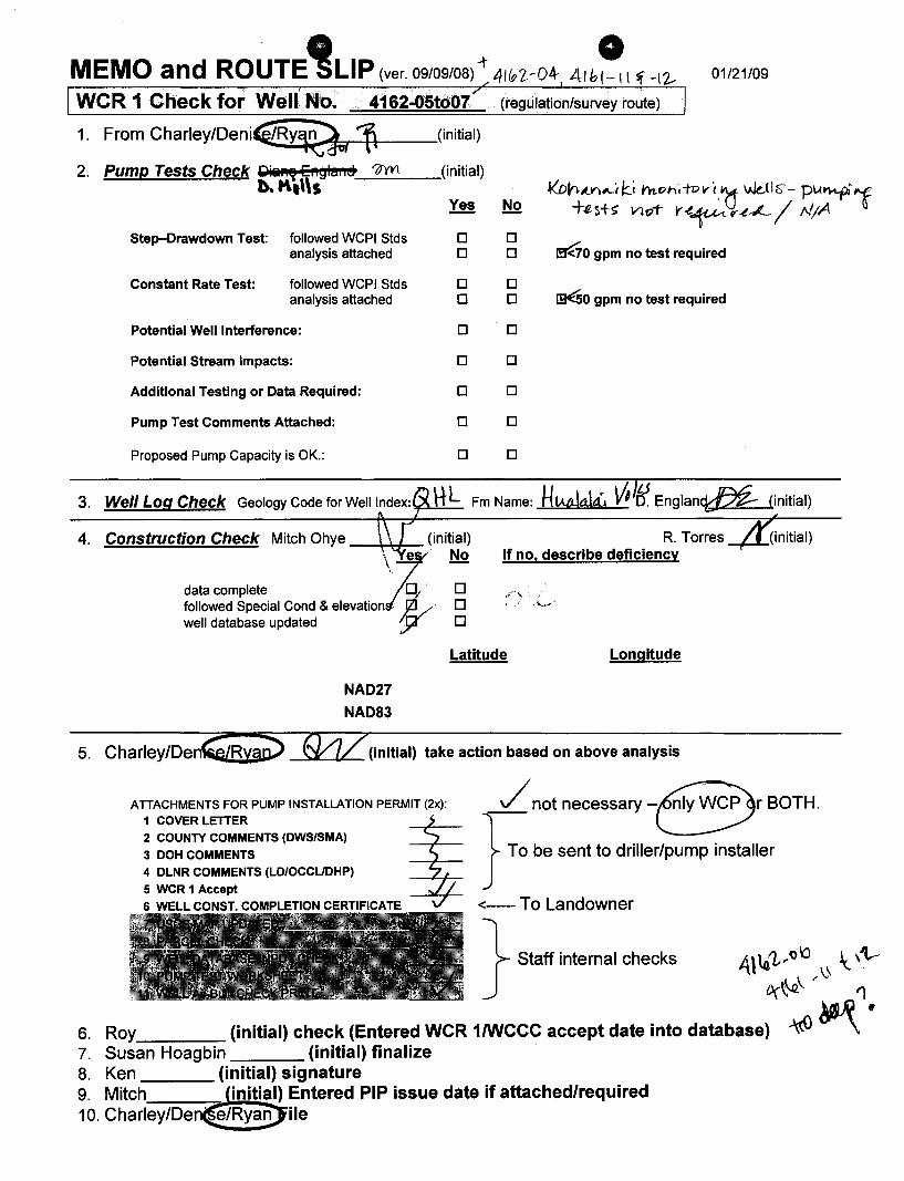
· • 0 MEMO and ROUTE "'SLIP (ver. 09/09/08) ~ 41&'[-04- 41hl-1 \ f -12.- 01/21/09
WCR 1 Check for Well No. 4162-05to07 (regulation/survey route)
1. From CharleY/Deni~RY,'9w 1\ (initial)
2. 11YYI (initial) PumEl, Tests Check gilillll8 EI1Sh!llleo b. K,\\S ~~,(Y)lLtI~.j h1.C>h·,ToY'i.~ Wdls- PIA~1
Yes No +~5+~ VloT r~~ ~.t---'- / MIA Step-Drawdown Test: followed WCPI Stds 0 0
~O gpm no test required analysis attached 0 0
Constant Rate Test: followed WCPI Stds 0 0 analysis attached 0 0 ~O gpm no test required
Potential Well Interference: 0 0
Potential Stream Impacts: 0 0
Additional Testing or Data Required: 0 0
Pump Test Comments Attached: 0 0
Proposed Pump Capacity is OK.: 0 0
3. Well Log Check Geology Code for Well Index: HL Fm Name: HIMklti. 01& Englan~ 4. Construction Check Mitch Ohye (initial) R. Torres
If no, describe deficiency
h' e ' No
data complete 0 / 0 followed Special Cond & elevation b· 0 well database updated jl 0
NAD27
NAD83
Latitude Longitude
5. Charley/Den._~~_ _~--""-- (initial) take action based on above analysis
(initial)
(initial)
ATTACHMENTS FOR PUMP INSTALLATION PERMIT (2x): 1 COVER LETTER
2 COUNTY COMMENTS (DWS/SMA)
3 DOH COMMENTS
4 DLNR COMMENTS (LD/OCCUDHP)
5 WCR 1 Accept
/ not necessary -Br BOTH.
} To be sent to driller/pump installer
6 WELL CONST. COMPLETION <------ To Landowner
} Staff internal checks
6. Roy (initial) check (Entered WCR 1IWCCC accept date into database) 7. Susan Hoagbin (initial) finalize 8. Ken (initial) signature 9. Mitch initial) Entered PIP issue date if attached/required 10. Charley/De e/Ryan ile

~ .. a .. a UI nanall COMMISSION. WATER RESOURCE MANAGEM~ Department of!lnd and Natural Resources
WELL COMPLETION REPORT· PART I Wei. Con.stuctton
1rIIIructJona: Please print in Ink or type lind I8f1d oampkdIId nIporl (with attachrnenIa, If applicat:Jto) to .., CorrmIIIaion on Watof Resource ManillgllJT18nL P.O. Box 621, HonoIukJ, HawaII 96809. The Comml8eIon may nOl aCCll{Jlt Incomplete rupoI1B.ThIe form Ihilil t. IUbmItIlId wtIhIn 60 daya of !tie 00ITlIJIuli0n of 'Noli!:. for 811&1atal'lt:e, pieeee 00fl$Uft ilD HIilW8iI WvlI COI1IIIn.don lind Pump II"dItaIIaftan Standards or call tho Rogulatiorl Branch at 58700221 For updates to ttWa f«m or additional IrrformatIol'I, pIea8e WIit our wetJaIIo fll http://www,state,hl uelcllnrlOMml
"'or OfJJclaJ Use Only:
9 JAN 20 A 9: 2 J
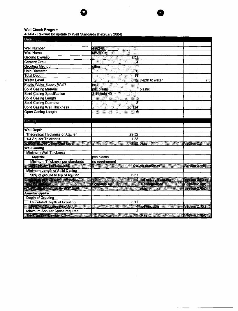
". ;;~., L" ',:.',1\ 1. Stale Wall No.: 4162-05 Well Name: MW 300a ------"\~4jI~Cf t(ew!!t'=MEtn 2. Address: P.O. Box 9165, Kallu8.-Kc:ma, HI _96_7_4_5 ____ Tax Map Key: 7-3-009:003
3. Drilling Company: Derrick's Well Drilling & Pump Se~!!=~
4. Drilling method used during construction: • Rotary [] Percussion 0 Other (describe)
5. Date Well Construction (drilled, eased, grouted} completed: 12/3{08 Aa.ctI CompIftId Ott ... '" Log muflUVdttyIyoa!
6. Was the subject we" cored? CJ Yes • No
7. Step-Drewdown Test completed? • No CJ Yes Attach et.p.Orawdvwn Test bm (12117117 SDPm Form)
8. Constant Rate
1 1. After casing Installation (thilllnforrn8tlon IIIIauId be before any p~ "' • ..-e perbmld wIIh cuing 1nltal1ed)
ChIorid9; ~ ppm, Temperature· N/A of
note: foiill ~ rofwotroed fr:I mMn .., IeVfll, ,.. Mhct the depth to (he It'IiIOr 1eII9I.
12. Aa-built sec:tIon filled In complet.ay •
• No CJ Yes
12/10/08 10:40 am
13. Photograph of ... , and conorete pad showing benchm..-k on concrete pad attached •
14. GPS coordinates provided In deg ...... mlnutM. seconds •
15. If a pump Is not planned to be installed. please desalbe (below In the remarks section) how well is secured to prevent unauthorized 8C08S8 (example: lockable cover, threaded coupling, etc.)
16. Remarks:
Licensed Driller (print)
Signature
Derrick Moreira
r;;b7~'--C-57 Uc. No. C-28001
Date .J~nuary 15, 2009
weR1 Fomt 6If'2J01 PegtJ 1 offj
/
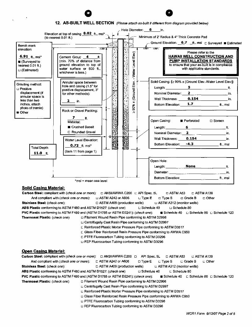
o 12. AS-BUILT WELL SECTION (Please attach as-built if different from diagram provided below)
Elevation at top of casing 8.02 ft., msl* \. L Hole Diameter' 6 in
(to nearest 0.01 ft.) ~c---r-_~C--~ Minimum of 2' Radius & 4" Thick Concrete Pad
~B:e=:n=:c::h-:m:a=:rk=----l--------------I.""-;I.:'::SI ~.;j r Ground Elevation: 6.7 ft., msl 0 Surveyed. Estimated
elevation: //~\ :.~:: :~.:: '1/""" '11m\
....------------, :-:: ~::. ~ Please refer to the 6.91 ft., msl*
• (Surveyed to nearest 0.01 ft.) o (Estimated)
Grouting method: o Positive
displacement (if annular space is less than two inches, attach photo oftremie)
• Other
Total Depth
11.0 ft.
Cement Grout: 4 ft. '::~'. ::~'. iIi (min. 70% of distance from .~.:.: ~.:.: ~ ground elevation to top of {(. ~{~ water surface or 500 ft., '.' .4; ...
whichever is less.) ~ X ~:::: i
HAWAII WELL CONSTRUCTION AND PUMP INSTALLATION STANDARDS to ensure that your as-built is in compliance
with applicable standards.
Annular space between hole and casing (1.5" for positive displacement, 3" for other methods):
:. ~ :. ~ . . ;. '.: ~.:.: ~ 11----1 Solid Casing: (;:: 90% x (Ground Elev.-Water Level Elev» .:::;. .: .. ' W .;.,. .~.:~.:'."t:l Length: 5 ft. r: § Nominal Diameter: _---'2~ ________ in.
/ £.:~~ /.~ §.. Wall Thickness: 0.154 in.
~~2~7~in~·~=ft=.==~> ~~~~':/""o{ I;'~ ~AXI Bottom Elevation:_--....:c1:....._
7 ______
ft., msl
Rock or Gravel Packing: ":~ v
Material:
• Crushed Basalt I o Rounded Gravel :\l';\'I'I---tV
~=====!.-I " Cl Water Level Elevation:
0.72 ft. msl*
(item 11 from page 1) _~I d ~~
*msl = mean sea level
Open Casing: • Perforated o Screen
Length: 6 ft.
Nominal Diameter: 2 in.
Wall Thickness: 0.154 in.
Bottom Elevation: -4.3 ft., msl
Open Hole:
Length: ____ --'-N.:..o:;.c""-e"'-_______ ft.
Diameter: _____________ in.
Bottom Elevation: _________ ft., msl
Solid Casing Material: Carbon Steel: compliant with (check one or more): 0 ANSI/AWWA C200 0 API Spec. 5L 0 ASTM A53 0 ASTM A139
And compliant with (check one or more): 0 ASTM A242 or A606 0 Type E 0 Type S 0 Grade B 0 Other
Stainless Steel: (check one): 0 ASTM A409 (production wells) 0 ASTM A312 (monitor wells)
ABS Plastic conforming to ASTM F480 and ASTM D1527: (check one) 0 Schedule 40 0 Schedule 80
PVC Plastic conformin9 to ASTM F480 and (ASTM D1785 or ASTM D2241): (check one): • Schedule 40 0 Schedule 80 0 Schedule 120
Thermoset Plastic: (check one) o Filament Wound Resin Pipe conforming to ASTM D2996
o Centrifugally Cast Resin Pipe conforming to ASTM D2997
o Reinforced Plastic Mortar Pressure Pipe conforming to ASTM D3517
o Glass Fiber Reinforced Resin Pressure Pipe conforming to AWWA C950
o PTFE Fluorocarbon Tubing conforming to ASTM D3296
o FEP Fluorocarbon Tubing conforming to ASTM D3296
Open Casing Material: Carbon Steel: compliant with (check one or more): 0 ANSI/AWWA C200 0 API Spec. 5L 0 ASTM A53 0 ASTM A139
And compliant with (check one or more): 0 ASTM A242 or A606 0 Type E 0 Type S 0 Grade B 0 Other
Stainless Steel: (check one): 0 ASTM A409 (production wells) 0 ASTM A312 (monitor wells)
ABS Plastic conforming to ASTM F480 and ASTM D1527: (check one) 0 Schedule 40 0 Schedule 80
PVC Plastic conforming to ASTM F480 and (ASTM D1785 or ASTM D2241): (check one): • Schedule 40 0 Schedule 80 0 Schedule 120
Thermoset Plastic: (check one) o Filament Wound Resin Pipe conforming to ASTM D2996
o Centrifugally Cast Resin Pipe conforming to ASTM D2997
o Reinforced Plastic Mortar Pressure Pipe conforming to ASTM D3517
o Glass Fiber Reinforced Resin Pressure Pipe conforming to AWWA C950
o PTFE Fluorocarbon Tubing conforming to ASTM D3296
o FEP Fluorocarbon Tubing conforming to ASTM D3296
weR1 Form 6/12107 Page 2 of 5
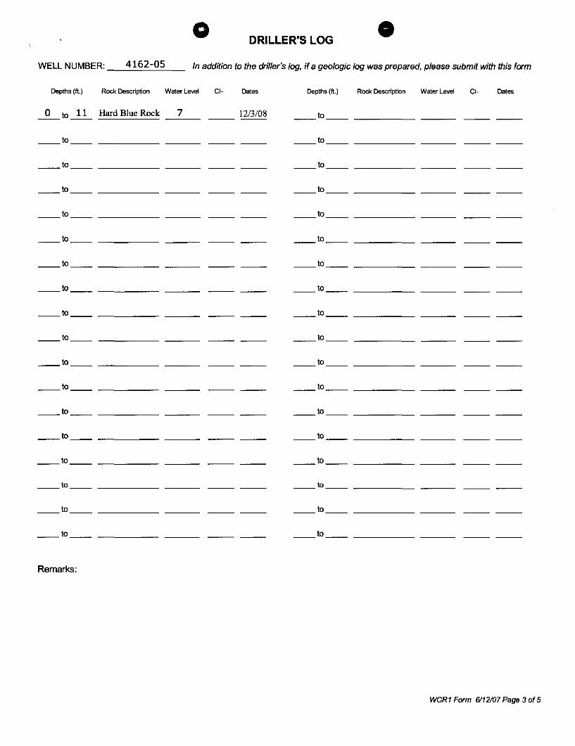
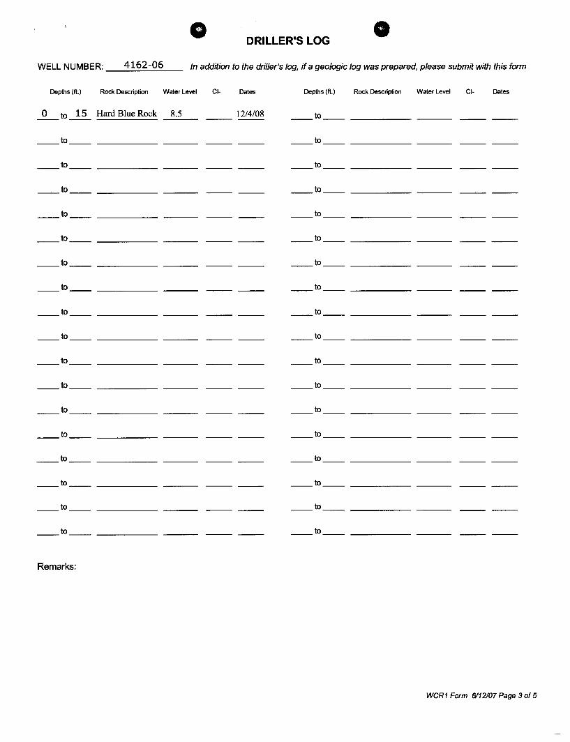
o DRILLER'S LOG
WELL NUMBER: __ 4_1_6_2_-_0_5 __ In addition to the driller's log, if a geologic log was prepared, please submit with this form
Depths (ft.) Rock Description Water Level CI- Dates Depths (ft.) Rock Description Water Level CI- Dates
_0_ to ~ Hard Blue Rock __ 7 __ 12/3/08 ____ to _____________ _
to to
__ w __ _____________ _ to
to _ __ w ____ __________ _
___ w __ _____________ _ ____ w ___ __________ _
___ w ___ _____________ _ __ __ w ___ __________ _
__ w ___ _____________ _ __w ____ __________ _
___ w ___ _____________ _ _ __ w ___ __________ _
__ w ___ _____________ _ _ __ to _____________ _
__ w ___ _____________ _ __w ___ __________ _
___ w ___ ________ _ _ __ w ___ __________ _
__ w ____ ______________ _ _ __ w ___ __________ _
___ w ___ ________ _ _ __ to __________________ _
___ w ____ __________ _ __w ___ ______________ _
___ w ___ _________ _ to
___ w ___ _________ _ to
___ w ____ _________ _ to
___ w ___ _________ _ to
Remarks:
weR1 Form 6112107 Page 3 of 5
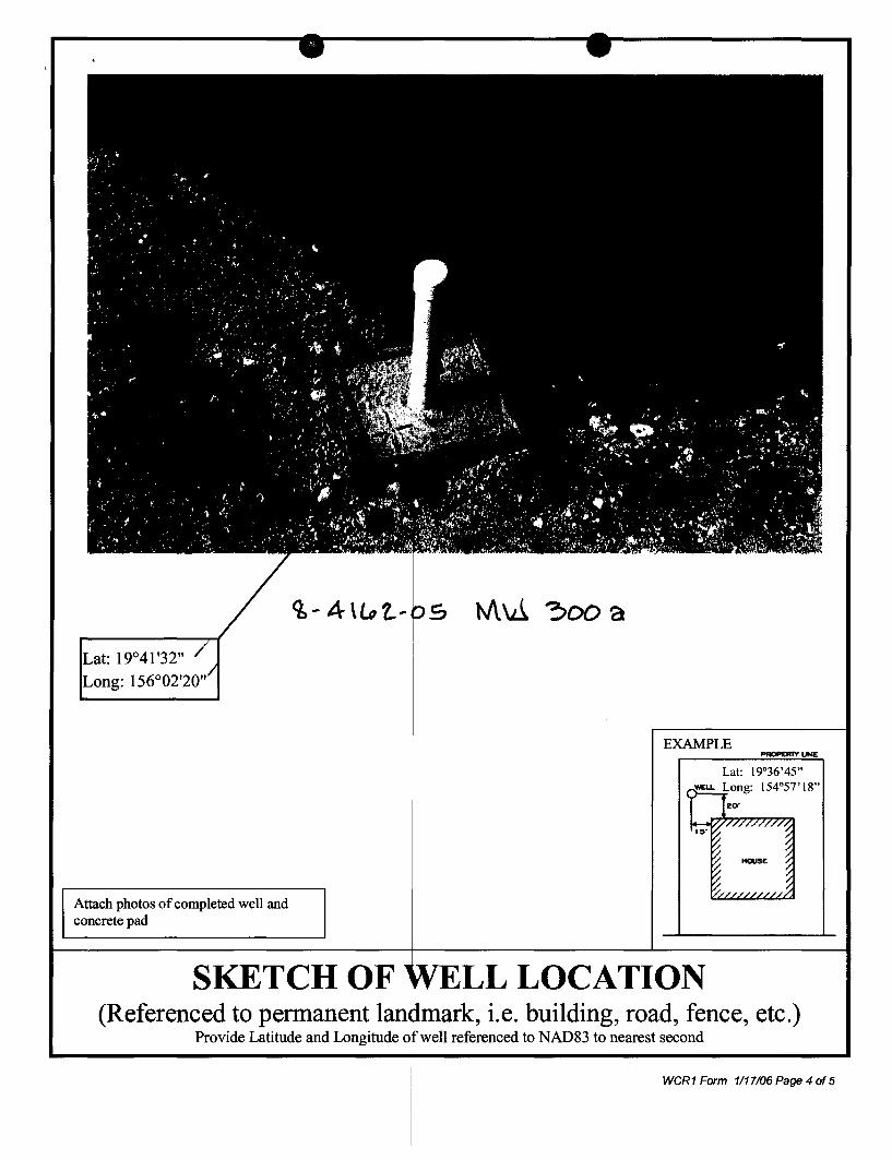
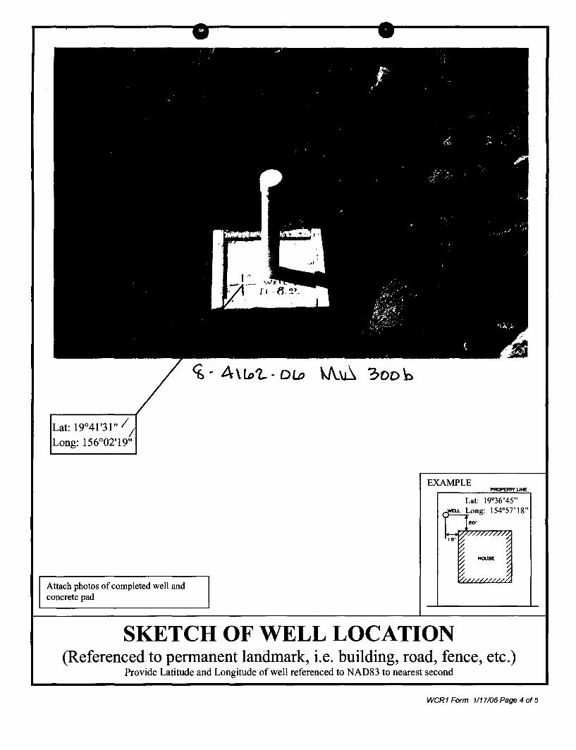
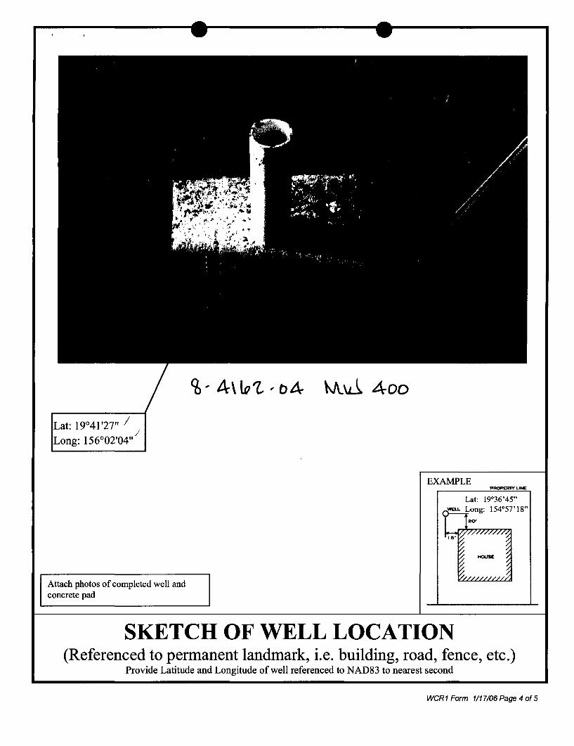
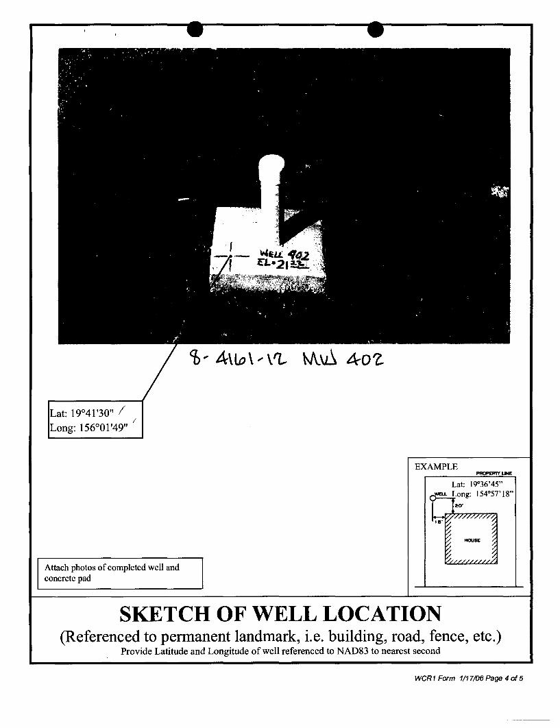
Attach photos of completed well and concrete pad
q,-4\l#t.. ..
EXAMPLE
Lat: 19°36'45"
SKETCH OF LL LOCATION (Referenced to permanent ............. ~ ...... .& ............... , i.e. building, road, fence, etc.)
Provide Latitude and Longitude well referenced to NAD83 to nearest second
weR1 Form 1117106 Page 4 of 5
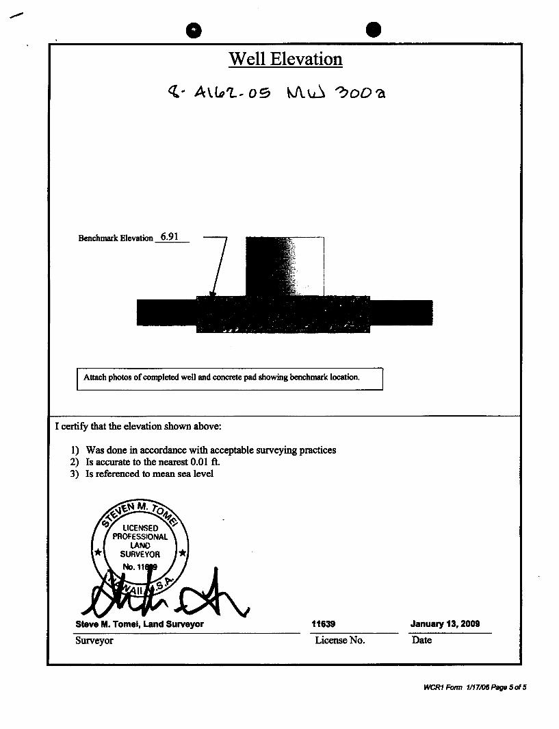
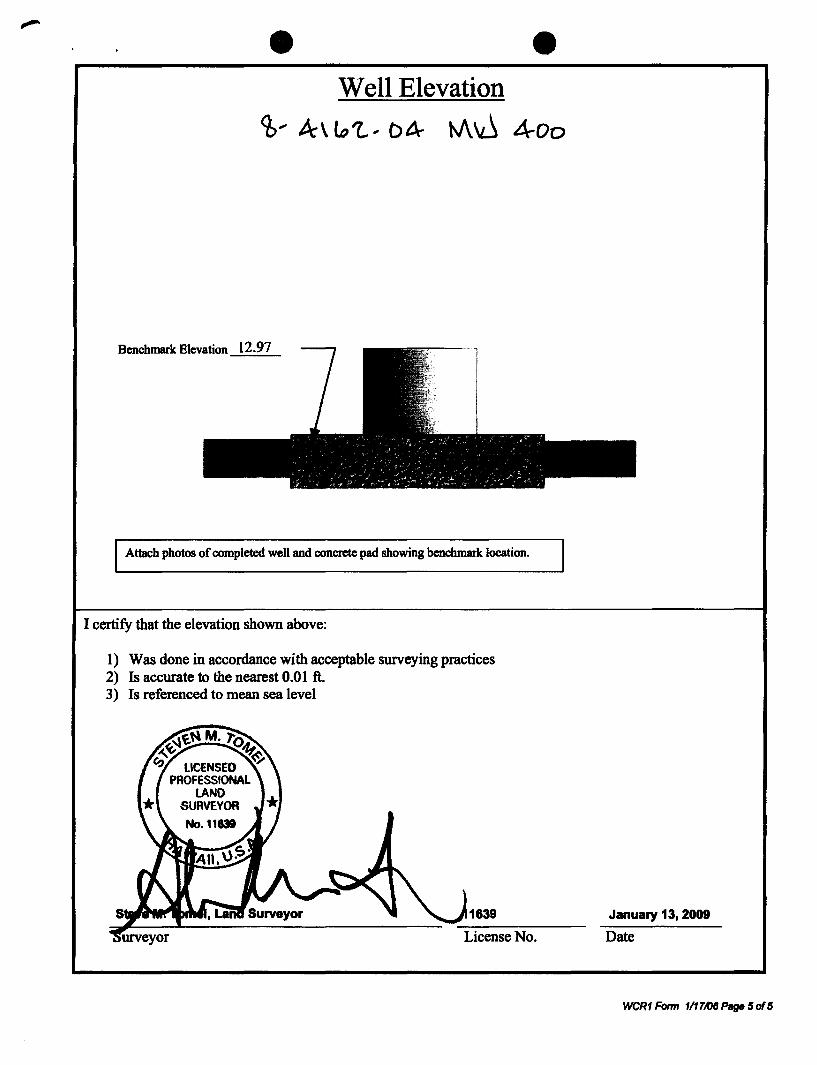
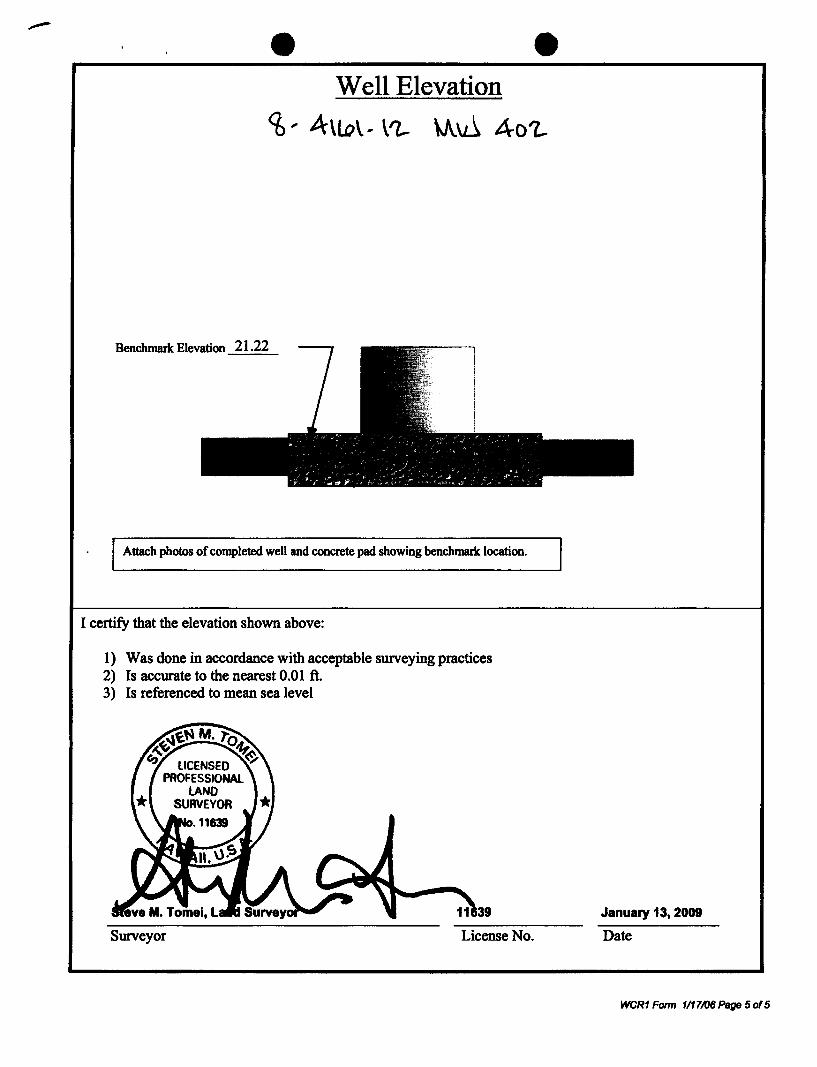
Well Elevation
Benchmark Elevation 6.91
Attach photos of completed well and concrete pad showing benchmark location.
I certify that the elevation shown above:
1) Was done in accordance with acceptable surveying practices 2) Is accurate to the nearest 0.01 ft. 3) Is referenced to mean sea level
Steve M. Tomei, Land Surveyor 11639
Surveyor License No.
January 13, 2009
Date
WCR1 Fonn 1117/06Psge sots
+
~i -.. ~" ~"';.;,~.;,~ai;ATER RESOURCE MANAGEM. I Department of nd and Natural Resources
_ WELL COMPLETION REPORT - PART I -. Well ConstNcrtion
IRItruc4Ions: Pie ... print In Ink or type and set1d oompIvIed .-.port (wID! daI:Ivnanta, If applicable) to It1e CummillMln on Water RIIIIOUI'C(l Managomonl. P.O. Box 821. Honolulu, H8WlIlI96809. The Commlselon may nol a~ Im:omplellt raporta. Thl$ form shall be ~ wi4h1n 60 days of !he ~I of wortI. For a ..... nce. ple •• e cortMIIt the Hawaii Well Coostruaton and Pump InwtaIhIUcrI standarda or call1he Regulallun 8r~d1 Ell 517 o02l5. For updatM 10 1his form a addi1ionlll Information, pluM IIIRIt O\M" wobsiIo 8l hnp:/Iwww ..... hl.uBldnJcwrml
"·OT um"I.J lile Only:
Zrt A9: Z 09 JAN v
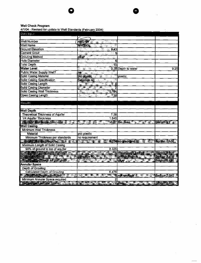
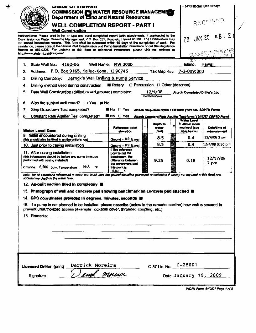
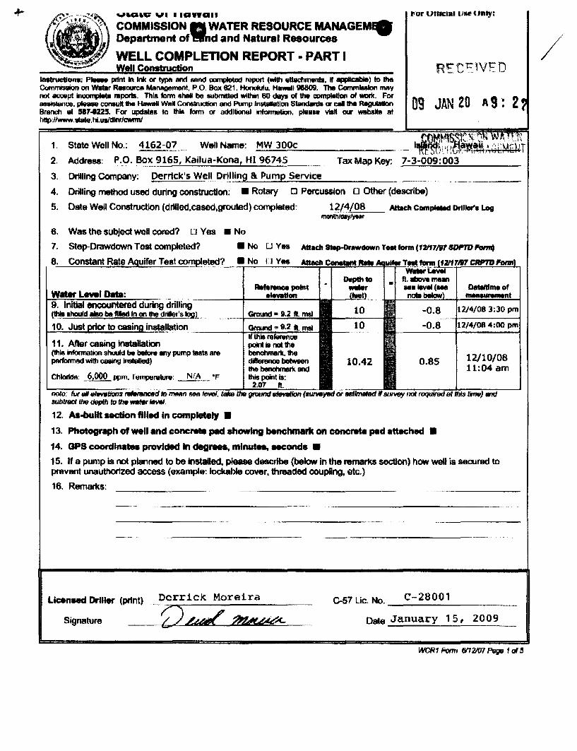
1. State Well No.: 4162-06 Well Name: MW 300b ___ Island: ...;.H.;.;;a;.;.w;..;;21;.;.;I1 __ _
2. Address: P.D: Box 9165, Kailua-Kona, HI ?6745 ___ Tax Map Key: 7-3-009:003
3. DrIlling Company: Der!lck's Well Drilling &. Pump Service
4. Drilling method used during construction: • Rotary 0 Percussion n Other (describe)
5. Date Well Construction (drilled,cased,grouted) completed: 1 Y4/08 Anach Comp""" Drll..,...log monIhfday/ytllor
6. Was the subject wetl cored? rJ Yes • No
7. Step-Drawdown Test completed? • No n Yes Attach "poOr .. ..., Test form (121f1117 SDPTD Form)
8. Constant Rate Aquifer TeElt """''1(l~~~~!7~~.~N~O~O~Y~e5!-..M!!!t~~Ir!!.~~~~m!!;!!!.1:!1!!J~~~~~
11. After cMng instalfation (!his information atKMd be b8fDre anv pump *t8 are perltllJllOO wMI1 ~ if1lblhd)
rIM fllev.lians tn$8Il 800 subIroct tmt dflpttr to 1M It'IIfer 1tweI.
12. As-built ucUon filled In completely •
13. Photograph of well and concrete pad .howIng benchmark on concnde pad attached •
14. CPS coordinates provided In dagraea. min ....... eec;ond5 •
15. If 8 pump is not planned to be installed, please deeaibe (below In the remarks sBCtion) how well is secured to prevent unauthorlzod access (axample: lockable cover, threaded coupling. etc.)
16. Remarks:
Licensed Driller (print) Derrick Moreira
Z2./.J'~._ C-57 Lie. No. C-28001
Date Jarll~ .. ~ry 15, 2009 Signature
WCR1 Form 6/1 V07 Pttg& 1 of .5

o 12. AS-BUILT WELL SECTION (Please attach as-built if different from diagram provided below)
Elevation at top of casing 9.43 ft., msl* l r (to nearest 0.01 ft.) I-- Minimum of 2' Radius & 4" Thick Concrete Pad
Hole Diameter' 6 in
..-.--. b ~~ r Ground Elevation: 7.9 ft., msl o Surveyed • Estimate Bench mark ~ I.':'; -;.:<j' elevation: 11~\ .~ .0 :t>;':. /IINO' /IINO'
'0 0 ' ',A:" "> Please refer to the ',4.
8.07 ft., msl* 5 ' '. ,'. Q) HAWAII WELL CONSTRUCTION AND Cement Grout: ft. '::~' ::~'. iIi _ (Surveyed to (min. 70% of distance from .~. '.: .. ' Q; PUMP INSTALLATION STANDARDS :-,,: .:: ;- > nearest 0.01 ft.) ground elevation to top of .:ll" Q) to ensure that your as-built is in compliance '!::: t/: ...J
o (Estimated) water surface or 500 ft., ... ;".; Cii with applicable standards. whichever is less.)
.~ .0
:-,:: . . .' ~ --., •• 6 ••
;,..; ,'. , :. ~. :.'~:. Annular space between 'i·:·: ~.:.: :> Solid Casing: (2 90% x (Ground Elev.-Water Level Elev)
Grouting method: Q)
hole and casing (1.5" for :;:t: .:",- iIi 5 o Positive ;.:. Length: ft. positive displacement. 3" rt :.:.::. "0
displacement (if c:
for other methods): .... ',".:: ::J Nominal Diameter: 2 in. .. ' e annular space is V .4 •• .6 ••
;"":4 ~'. :4 Q. Wall Thickness: 0.154 in. less than two 2 in. --- .: :: :. ~. inches, attach
x 2.9 :-.-: ~ Bottom Elevation: ft., msl
photo oftremie) ---, I-- 0
Rock or Gravel Packing: m • Other /\1
10 I I ft. h Material: Open Casing: • Perforated o Screen , • Crushed Basalt Length: 10
~~ :/ o Rounded Gravel b~ Nominal Diameter: 2 t7
'I Wall Thickness: 0.154 Water Level Elevation:
0.18 ft. msl* Bottom Elevation: -7.1 Total Depth -''-- - :-
15.0 ft. (item 11 from page 1)
Open Hole:
Length: None
Diameter:
- Bottom Elevation: *msl = mean sea level
Solid Casing Material: Carbon Steel: compliant with (check one or more): 0 ANSIIAWWA C200 0 API Spec. 5L o ASTM A53 o ASTMA139
o Other And compliant with (check one or more): 0 ASTM A242 or A606 0 Type E o Type S 0 Grade B
Stainless Steel: (check one): 0 ASTM A409 (production wells) o ASTM A312 (monitor wells)
ABS Plastic conforming to ASTM F480 and ASTM 01527: (check one) o Schedule 40 o Schedule 80
ft.
in.
in.
ft., msl
ft.
in.
ft., msl
PVC Plastic conforming to ASTM F480 and (ASTM 01785 or ASTM 02241): (check one): • Schedule 40 0 Schedule 80 0 Schedule 120
Thermoset Plastic: (check one) 0 Filament Wound Resin Pipe conforming to ASTM 02996
o Centrifugally Cast Resin Pipe conforming to ASTM 02997
o Reinforced Plastic Mortar Pressure Pipe conforming to ASTM 03517
o Glass Fiber Reinforced Resin Pressure Pipe conforming to AWWA C950
o PTFE Fluorocarbon Tubing conforming to ASTM 03296
o FEP Fluorocarbon Tubing conforming to ASTM 03296
Open Casing Material: Carbon Steel: compliant with (check one or more): 0 ANSIIAWWA C200 0 API Spec. 5L 0 ASTM A53 0 ASTM A139
And compliant with (check one or more): 0 ASTM A242 or A606 0 Type E 0 Type S 0 Grade B 0 Other
Stainless Steel: (check one): 0 ASTM A409 (production wells) 0 ASTM A312 (monitor wells)
ABS Plastic conforming to ASTM F480 and ASTM 01527: (check one) 0 Schedule 40 0 Schedule 80
PVC Plastic conforming to ASTM F480 and (ASTM 01785 or ASTM 02241): (check one): _ Schedule 40 0 Schedule 80 0 Schedule 120
Thermoset Plastic: (check one) o Filament Wound Resin Pipe conforming to ASTM 02996
o Centrifugally Cast Resin Pipe conforming to ASTM 02997
o Reinforced Plastic Mortar Pressure Pipe conforming to ASTM 03517
o Glass Fiber Reinforced Resin Pressure Pipe conforming to AWWA C950
o PTFE Fluorocarbon Tubing conforming to ASTM 03296
o FEP Fluorocarbon Tubing conforming to ASTM 03296
WCR1 Form 6112107 Page 2 of 5
d
o DRILLER'S LOG
WELL NUMBER: __ 4_1_6_2_-_0_6 __ In addition to the driller's log, if a geologic log was prepared, please submit with this form
Depths (ft.) Rock Description Water Level CI- Dates Depths (ft.) Rock Description Water Level CI- Dates
_0 __ to ~ Hard Blue Rock 8.5 12/4/08 ___ ID _________ _
__ ID ________ _ ___ID _________ _
___ ID _________ _ ___ ID _________ _
to ___ID _________ _
to ___ w ___ ______ _
___ ID _________ _ to
___ ID _________ _ ___ID _________ _
___ ID _________ _ ___ID _________ _
to ___ID _________ _
to ___ w ___ ______ _
___ ID _________ _ to
___ ID _________ _ to
___ ID _________ _ to
__ ID _________ _ to
to to
___ w ___ ______ _ to
___ w ___ ______ _ to
__ w ___ ______ _ to
Remarks:
WCR 1 Form 6112107 Page 3 of 5
Attach photos of completed well and concrete pad
EXAMPLE
SKETCH OF WELL LOCATION (Referenced to permanent landmark, i.e. building, road, fence, etc.)
Provide Latitude and Longitude of well referenced to NAD83 to nearest second
weR1 Form 1117106 Page 4 of 5
Well Elevation
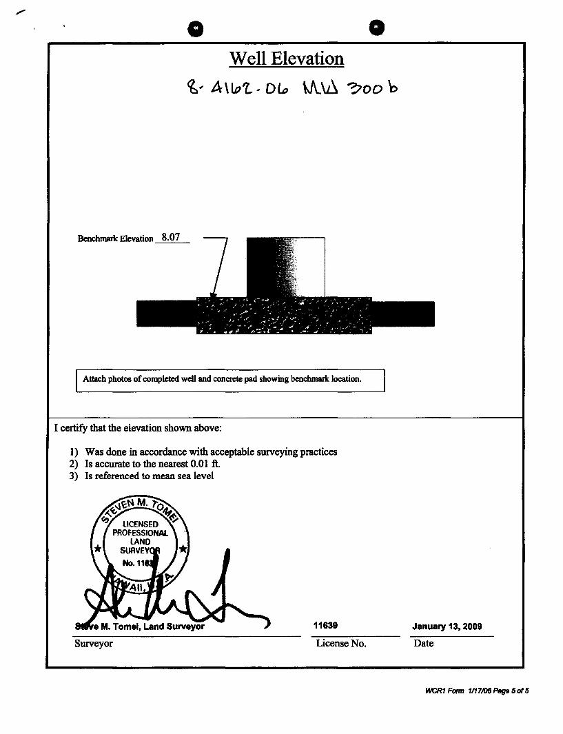
~ .. A\lo'Z.. .. DL, \J\.~ ~oo 'b
Benchmark Elevation 8.07
Attach photos of completed well and concrete pad showing benchmark location.
I certify that the elevation shown above:
1) Was done in accordance with acceptable surveying practices 2) Is accurate to the nearest 0.01 ft. 3) Is referenced to mean sea level
11639
Surveyor License No.
January 13, 2009
Date
WCR1 Form 1117t06Page 50f5
,9>~; .:.~ COMMIss.c;~ai;ATER RESOURCE MANAGE,..
•
Department of d and Natural Resources
'__ WELL COMPLEnON REPORT • PART I .... WeI! Construction
.. or UfllClallJIltH'III)':
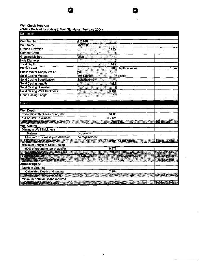
1. State Well No.: 4162-07 Wen Name: .:...M:...:.W-=-=.3.::..00.:;.;c~ _______ _
2. Address: P.O. Box 9165, Kailua-Kona, HI 96745 Tax Map Key:
3. Drilling Company: Oernck's w..~11 Dri~!~ng &. Pump Service
4. Drilling method u8ed during construction: • Rotary CI Percussion 0 other (describe)
5. Dale Wen Construction (drilled,eased,grouted) completed: 1~/4/08 AtbIch Com ...... Driller'. Log ~.r
6. Was the subjed: woll cored? Ll Ves • No
7. Step-OrawdownTestoompieted? • No U Vn Atlach~nT"'fonn(121"17mSDPJ'D""""
8. '~.~No~~O~Y~_~~~~~~~~~~.~~~~~~~~
11. After casing installation (1t1i8 information shuuId be baftn lillY pump tem are paIfnrmed with 008lng 1r1$II8IIed)
ChlorldA: 6,000 ppm. TVmperat\l,.; NIA
note: all elw81ion.- nlWMn sea S'Ubtrocf thIe dtIpfh h:l the Mtw 1ewII.
12. As-bullt _action filled in complNIy •
13. Photograph of well and concm. pad ahowlng benchmark on concntta pad attached •
14. OPS coordi ...... provided In d!gr!es. minutes, aeconda •
15. If a pump is not planned to be Installed, please describe (below in the remarks section) how well is secured to prevent unauthorized access (exampta: lockable cover, threaded coupling, etc.)
16. Remarks:
UcenHd DrIller (prtnt) Derrick Moreira
_~n0LuL~ C-57 Lie, No. __ C_-_2_8_0_0_1 ___ ~_
Signature Dale January 15, 2009

o o 12. AS-BUILT WELL SECTION (Please attach as-built if different from diagram provided below)
Elevation at top of casing 11.27 ft., mSI*l r (to nearest 0.Q1 ft.) _ ~ Minimum of 2' Radius & 4" Thick Concrete Pad
Hole Diameter· 6 in
.-.-. ~ 1:7..~ L Ground Elevation: 8.9 ft., msl o Surveyed • Estimate Bench mark l·:'; .~.:.; elevation: Il~\ 'to., :t>.:. '/IM" '/,w.,
" " ',.: : • ,II.. >" Please refer to the 9.05 ft., msl*
~ .: •.. CI) HAWAII WELL CONSTRUCTION AND Cement Grout: 4 ft. ':.'~' :. ~. iii
• (Surveyed to (min. 70% of distance from .~:.: ...
Qi PUMP INSTALLATION STANDARDS ~'.,: > nearest 0.01 ft.) ground elevation to top of '.:l>'" .:"" CI) to ensure that your as-built is in compliance
'~:: .• ;.:. -I
o (Estimated) water surface or 500 ft., •••• I!i; '0 '~'. :u with applicable standards. :",:: . whichever is less.) . ",,-
I"---' :-,:: . ,",4: '0 ~ ... ;,.;
, :. ~. :.'~'. Annular space between .;. "0: ... -> Solid Casing: (~ 90% x (Ground Elev.-Water Level Elev)
Grouting method: ~'.,: CI)
hole and casing (1.5" for :i~:;: .:",- iii 4.2 o Positive ;.:. Length: ft. positive displacement, 3" ~
'0 '~'. "0 c
displacement (if for other methods): :l>::. ::l Nominal Diameter: 2 in. V:··:·· ... e annular space is .4 ••
~ -:4 ~·-:4 ~ Wall Thickness: 0.154 in. less than two 2 in. --- ::~ .. ::~ .. x inches, attach
... ;. ... : 4.7 ~ Bottom Elevation: ft., msl photo of tremie) 0
Rock or Gravel Packing: OJ • Other III
7 ft. Material:
:~I;
B I Open Casing: • Perforated o Screen
• Crushed Basalt Length: 10 o Rounded Gravel
" ~~ Q~ :/ Nominal Diameter: 2
Water Level Elevation: ?~~ Wall Thickness: 0.154
Bottom Elevation: -5.3 0.85 ft. msl* Total Depth _L- ~ - c-
14.2 ft. (item 11 from page 1)
Open Hole:
Length: None Diameter:
- Bottom Elevation: *msl = mean sea level
Solid Casing Material: Carbon Steel: compliant with (check one or more): 0 ANSI/AWWA C200 0 API Spec. 5L o ASTM A53 o ASTMA139
o Other And compliant with (check one or more): 0 ASTM A242 or A606 0 Type E o Type S 0 Grade B
Stainless Steel: (check one): 0 ASTM A409 (production wells) o ASTM A312 (monitor wells)
ABS Plastic conforming to ASTM F480 and ASTM D1527: (check one) 0 Schedule 40 0 Schedule 80
ft.
in.
in.
ft., msl
ft.
in.
ft., msl
PVC Plastic conforming to ASTM F480 and (ASTM D1785 or ASTM D2241): (check one): • Schedule 40 0 Schedule 80 0 Schedule 120
Thermoset Plastic: (check one) 0 Filament Wound Resin Pipe conforming to ASTM D2996
o Centrifugally Cast Resin Pipe conforming to ASTM D2997
o Reinforced Plastic Mortar Pressure Pipe conforming to ASTM D3517
o Glass Fiber Reinforced Resin Pressure Pipe conforming to AWWA C950
o PTFE Fluorocarbon Tubing conforming to ASTM D3296
o FEP Fluorocarbon Tubing conforming to ASTM D3296
Open Casing Material: Carbon Steel: compliant with (check one or more): 0 ANSI/AWWA C200 0 API Spec. 5L 0 ASTM A53 0 ASTM A139
And compliant with (check one or more): 0 ASTM A242 or A606 0 Type E 0 Type S 0 Grade B 0 Other
Stainless Steel: (check one): 0 ASTM A409 (production wells) 0 ASTM A312 (monitor wells)
ABS Plastic conforming to ASTM F480 and ASTM D1527: (check one) 0 Schedule 40 0 Schedule 80
PVC Plastic conforming to ASTM F480 and (ASTM D1785 or ASTM D2241): (check one): • Schedule 40 0 Schedule 80 0 Schedule 120
Thermoset Plastic: (check one) o Filament Wound Resin Pipe conforming to ASTM D2996
o Centrifugally Cast Resin Pipe conforming to ASTM D2997
o Reinforced Plastic Mortar Pressure Pipe conforming to ASTM D3517
o Glass Fiber Reinforced Resin Pressure Pipe conforming to AWWA C950
o PTFE Fluorocarbon Tubing conforming to ASTM D3296
o FEP Fluorocarbon Tubing conforming to ASTM D3296
weR1 Form 6112107 Page 2 of 5
d

DRILLER'S LOG o
WELL NUMBER: __ 4_16_2_-_0_7 __ In addition to the driller's log, if a geologic log was prepared, please submit with this form
Depths (ft.) Rock Description Water Level CI- Dates Depths (ft.) Rock Description Water Level CI- Dates
_0_ to ~ Hard Blue Rock 10 12/4/08 ____ ID ______________ _
.!!L. to ~ Hard Blue Rock 10 12/4/08 ____ ID ______________ _
~ to ~ Loose Cinders, caved in ____ ID ______________ _
to ____ ID ______________ _
to ____ ID ______________ _
to ____ ID ______________ _
to ____ to ______________ _
to ____ ID ______________ _
to ____ ID ______________ _
to ____ ID ______________ _
to ____ ID ______________ _
to ____ ID ______________ _
to ____ ID ______________ _
to ____ ID ______________ _
____ ID ______________ _ ____ ID ______________ _
____ ID ______________ _ __ __ ID ______________ _
____ ID ______________ _ __ __ ID ______________ _
____ ID ______________ _ __ __ ID ______________ _
Remarks:
weR1 Form 6112107 Page 3 of 5
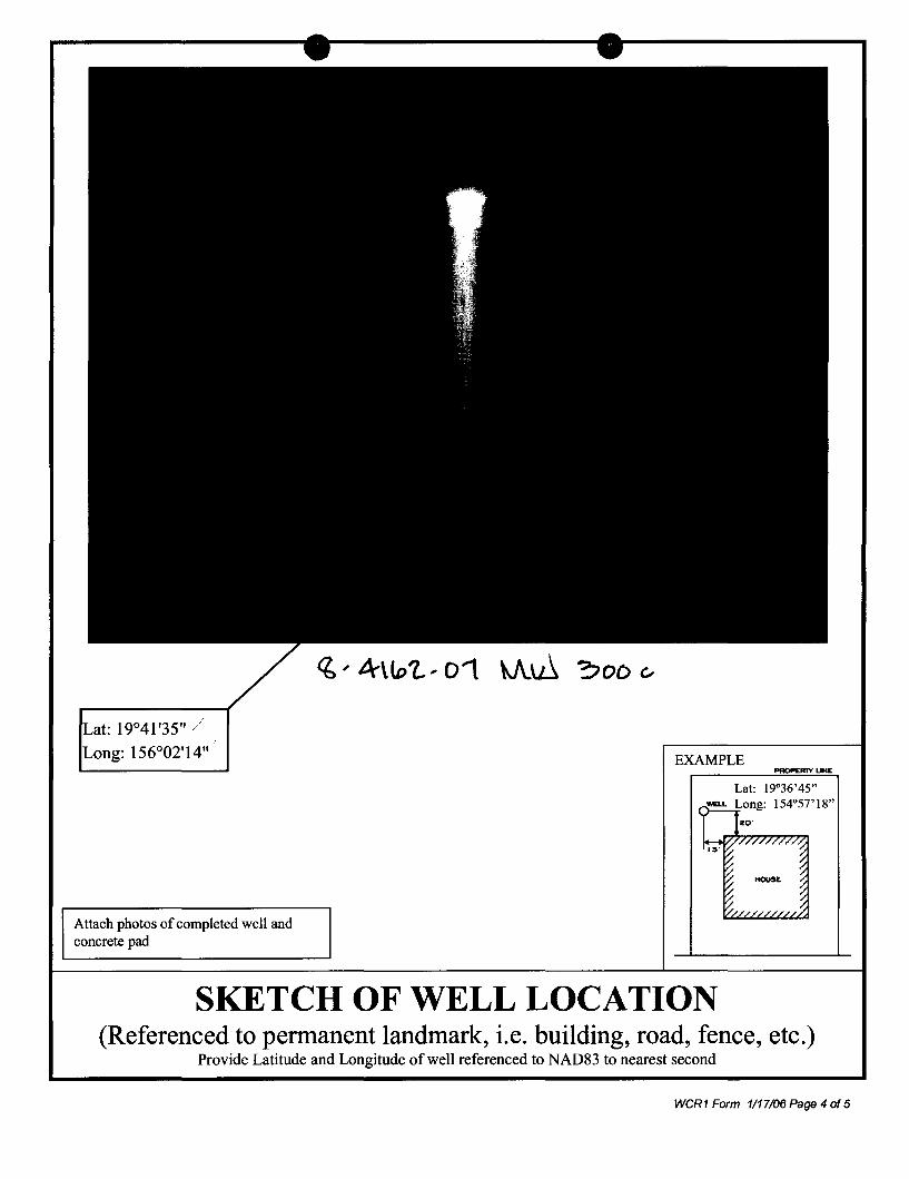
19°41 '35"
I.LJV'UJO,. 156°02'14"
Attach photos of completed well and concrete pad
q, .. 4\101., 01
EXAMPLE
SKETCH OF WELL LOCATION (Referenced to permanent landmark, i.e. building, road, fence, etc.)
Provide Latitude and Longitude of well referenced to NAD83 to nearest second
weR1 Form 1117106 Page 4 of 5

Well Elevation
<6 .. 4\to'l.. .. 01 W\.~ "?oo '"
Benchmark Elevation 9.05
Attach photos of completed well and concrete pad showing benchmark location.
I certify that the elevation shown above:
1) Was done in accordance with acceptable surveying practices 2) Is accurate to the nearest 0.01 ft. 3) Is referenced to mean sea level
11639
Surveyor License No.
January 13, 2009
Date
WCR1 Form 1117/06 Page 5 of 5
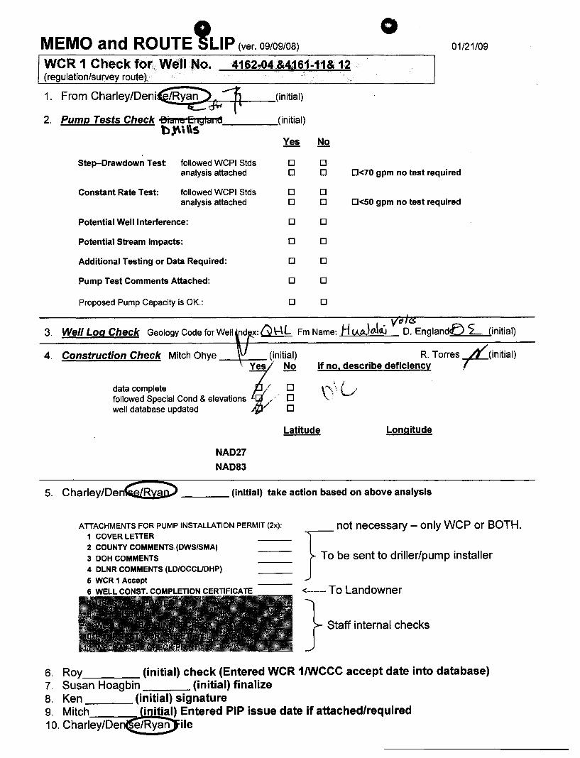
MEMO and ROUTE !LlP (ver. 09/09/08)
o 01/21/09
WCR 1 Check for Well No. 4162-04 &4161-11& 12 (regulation/survey route)
1. From CharleY/Denic(IRY@Jli1 (initial)
2. Pump Tests Check oBia"6 Ei iglaiilj b~\\\s ----
(initial)
Step-Drawdown Test: followed WCPI Stds analysis attached
Constant Rate Test: followed WCPI Stds analysis attached
Potential Well Interference:
Potential Stream Impacts:
Additional Testing or Data Required:
Pump Test Comments Attached:
Proposed Pump Capacity is OK.:
Yes
0 0
0 0
0
0
0
0
0
No
0 0 0<70 gpm no test required
0 0 0<50 gpm no test required
0
0
0
0
0
. VdJZS 3. Well Log Check Geology Code for Well nd x: G \-\L Fm Name: H <AlA.,.lold./ D. Englandt> <£-. (initial)
4. Construction Check Mitch Ohye . init~D~
data complete / followed Special Cond & elevations 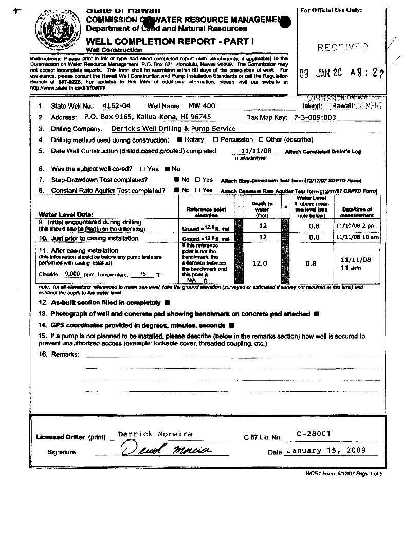
-:"~'~""~7~~ ~ .. CUV UI nitwit .. ~/" \ .. ~~ ... \\ COMMISSION ~ATER RESOURCE MANAGEME'e ~ l Department of ~d and Natural Resources
. ~ WELL COMPLETION REPORT • PART I
For Offida] Vile Only:
Well construction lMIrueIt""e: Pl .... print i1 Ink ar type and sand c:ompIeted report (WICh Quachmems. if epptCllble) to the / Commi5lskln on Wilier Resoorce ManageITWlt, P.O. Box 621. HoooIuIu. HawaiI 913&19. The Commlalan may not eccept incvmpl_ rttprXtB. ThIll ftlrm &hal tH:I eubmmed Vlfthin 60 deys of the ccmplllllon 01 work. Fo, 09 JAN 2f'1 A 9' 2" uwl&tenCie. please consult IhII HawaII Well CQI'l611"lJdton and Pump Inslallation 8turJdefl1& or call ttllt Rllgulalon 'U. ( Bfilnch ut 587..QU5. Far updatu to thlA form or additional infollTlQlIon. p\elllle vi5lit our webslta at hUp:llwww.stav.hi.ualdlnr/cwrmt
\J, i I";, ,_ ~ ;' \
1. State Well No.: 4162-04 Well Name: M..:..::W_4-'-'O:..:0'--________ I~~!. ;~~j!,(;U,\ELL
2. Address: P.O. Box_ 9165, Kailua-Kana, HI 96745 Tax Map Key: 7~_-..=.3-"-O::..:O~9:..:.:0:::.:0=-::3~ ___ _
3. Dr1l11ng Company: Derrick's Well "-filling .~ . ..:....P=_um:..:=p-=S:...:e::.:..rv..:...i:.::ce.::._ ________ _
4. Drilling method used during construction: • Rotary 0 Percussion 0 other (describe)
5. Dale Well Construction (dr1l1ed,eased,grouted) completed: 11/11/08 Abch CcInIpfNd Dril..,.. Log ~YIYe.r .. -
6. Was the subject well cored? u Yes • No
7. Step-Drawdown Test completed? • No 0 Yes Atbch Steop-Drawdown TNt form (12117m 8DPTD Form)
6. Constant Rata Aquifer Test compl~~? • ~No~_O~-·~y~as~...M!~~!!!!!!!!U!!!!~~~~~~~'1r.~~
Water Lavel Data: 9. InHIaI encountered during drilling (lhia IhouId Ho tH:I flied ill 00 the drIIIor'$log)
10. Just prior to c8sinA jnstal~lon
11. After casing installation (thi$ infofma1ion should bv befonI any pump testll are performOO with oasIng irl*led)
Chlorlda' ~wm. 1urnlN'lllure: 75 -F
nolo. fat II"CJlvV8tk7M ~ to miMn~MllQiiiMii:tUiQiij;;;;;r;;;;iiOn1iUi:;;:a sublroof thEr depffl to the MrIw 1fMtI.
12. As-bullt .action filled in completely •
0.8
0.8
11/10/Ott 2. pm
11/1
11/11/08 11 am
13. Photograph of well and concrea. pad showing benchmark on concret. pad attached •
14. GPS coordlnaIM provided In degrees. mlnu ..... .conde •
15. If a pump is not planned to be Installed, please describe (below in the remark$ section) how well is secured to prevent unauthorized access (example: lockable oover, threaded COUpling. etc.)
16. Remarks:
C-57 Lie. No. __ C_-_2_8_0_0_' ____ _ Licensed Driller (print) Derrick Moreira
__ r2~~~ Date January 15, 2009 Signature
WCR1 Fonn 6112107 PrI{J9 1 Q{ 5
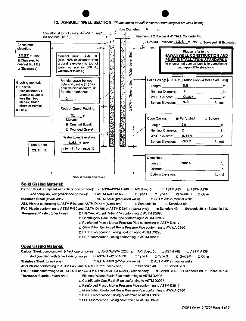
12. AS-BUILT WELL SECTION (Please attach as-built if different from diagram provided below)
Elevation at top of casing 13.72 ft., mSI"l r (to nearest 0.01 ft.) _ c,- Minimum of 2' Radius & 4" Thick Concrete Pad
Hole Oiameter· 6 in
-.-: ~ ~ r Ground Elevation: 12.8 ft., msl o Surveyed • Estimate .~ Bench mark T·- :.:'. '.:~'. .. elevation: II'*" "1>.- :t:':: /11Ji!!..' /flJi!!..'
',0' • .6 •• . .. "> Please refer to the
12.97 ft., msl" 2.5 ~ .: •.. Q)
HAWAII WELL CONSTRUCTION AND Cement Grout: ft. :. ~. ::~'. iIi • (Surveyed to (min. 70% of distance from .~. 0,: .,.
(jj PUMP INSTALLATION STANDARDS ~'.': .::";. > nearest 0.01 ft.) ground elevation to top of ,',l>"
Q) to ensure that your as-built is in compliance .~::: ~ :~.: ...J
o (Estimated) water surface or 500 ft., ..•. 4: :u with applicable standards. whichever is less.) "lI-.' '11' •• ..... . ..
~ I---e • .40 06 •• · .. ~ ... · . , ::~'. .. ,
Solid Casing: (2 90% x (Ground Elev.-Water Level Elev) Annular space between ":.:.: ',. :> Grouting method:
4, 0' Q)
hole and casing (1.5" for :;:t: :: ;. iIi 3.5 o Positive :)~ Length: ft.
positive displacement, 3" rf "C
displacement (if c:
for other methods): .... :::l Nominal Oiameter: 2 in . annular space is /
:4:" :~: 0, E! ;.· ... 4 ~ .. :4
~ Wall Thickness: 0.154 in. less than two 2 in. --- :. ~. :. '~:. inches, attach
.,. x 9.3 · . ~ Bottom Elevation: ft., msl
photo oftremie) - f-- 0
Rock or Gravel Packing: Ol
• Other 1\1
21 ft. I I ~
Material: Open Casing: • Perforated D Screen
• Crushed Basalt Length: 20
V D Rounded Gravel ~~ Nominal Oiameter: 2 'V ~
~ i ~ Wall Thickness: 0.154 Water Level Elevation:
1.68 ft. msl" ~ Bottom Elevation: -10.7 TotalOepth ~-_L- r-23.5 ft.
(item 11 from page 1)
Open Hole:
Length: None
Oiameter: - Bottom Elevation:
"msl = mean sea level
Solid Casing Material: Carbon Steel: compliant with (check one or more): 0 ANSI/AWWA C200 0 API Spec. 5L o ASTM A53 o ASTMA139
o Other And compliant with (check one or more): 0 ASTM A242 or A606 0 Type E o Type S 0 Grade B
Stainless Steel: (check one): 0 ASTM A409 (production wells) o ASTM A312 (monitor wells)
ASS Plastic conforming to ASTM F480 and ASTM 01527: (check one) 0 Schedule 40 0 Schedule 80
ft.
in.
in.
ft., msl
ft.
in.
ft., msl
PVC Plastic conforming to ASTM F480 and (ASTM 01785 or ASTM 02241): (check one): • Schedule 40 0 Schedule 80 0 Schedule 120
Thermoset Plastic: (check one) 0 Filament Wound Resin Pipe conforming to ASTM 02996
o Centrifugally Cast Resin Pipe conforming to ASTM 02997
o Reinforced Plastic Mortar Pressure Pipe conforming to ASTM 03517
o Glass Fiber Reinforced Resin Pressure Pipe conforming to AWWA C950
o PTFE Fluorocarbon Tubing conforming to ASTM 03296
o FEP Fluorocarbon Tubing conforming to ASTM 03296
Open Casing Material: Carbon Steel: compliant with (check one or more): 0 ANSI/AWWA C200 0 API Spec. 5L 0 ASTM A53 0 ASTM A139
And compliant with (check one or more): 0 ASTM A242 or A606 0 Type E 0 Type S 0 Grade B 0 Other
Stainless Steel: (check one): 0 ASTM A409 (production wells) 0 ASTM A312 (monitor wells)
ASS Plastic conforming to ASTM F480 and ASTM 01527: (check one) 0 Schedule 40 0 Schedule 80
PVC Plastic conforming to ASTM F480 and (ASTM 01785 or ASTM 02241): (check one): • Schedule 40 0 Schedule 80 0 Schedule 120
Thermoset Plastic: (check one) o Filament Wound Resin Pipe conforming to ASTM 02996
o Centrifugally Cast Resin Pipe conforming to ASTM 02997
o Reinforced Plastic Mortar Pressure Pipe conforming to ASTM 03517
o Glass Fiber Reinforced Resin Pressure Pipe conforming to AWWA C950
o PTFE Fluorocarbon Tubing conforming to ASTM 03296
o FEP Fluorocarbon Tubing conforming to ASTM 03296
WCR1 Form 6112107 Page 2 of 5
d
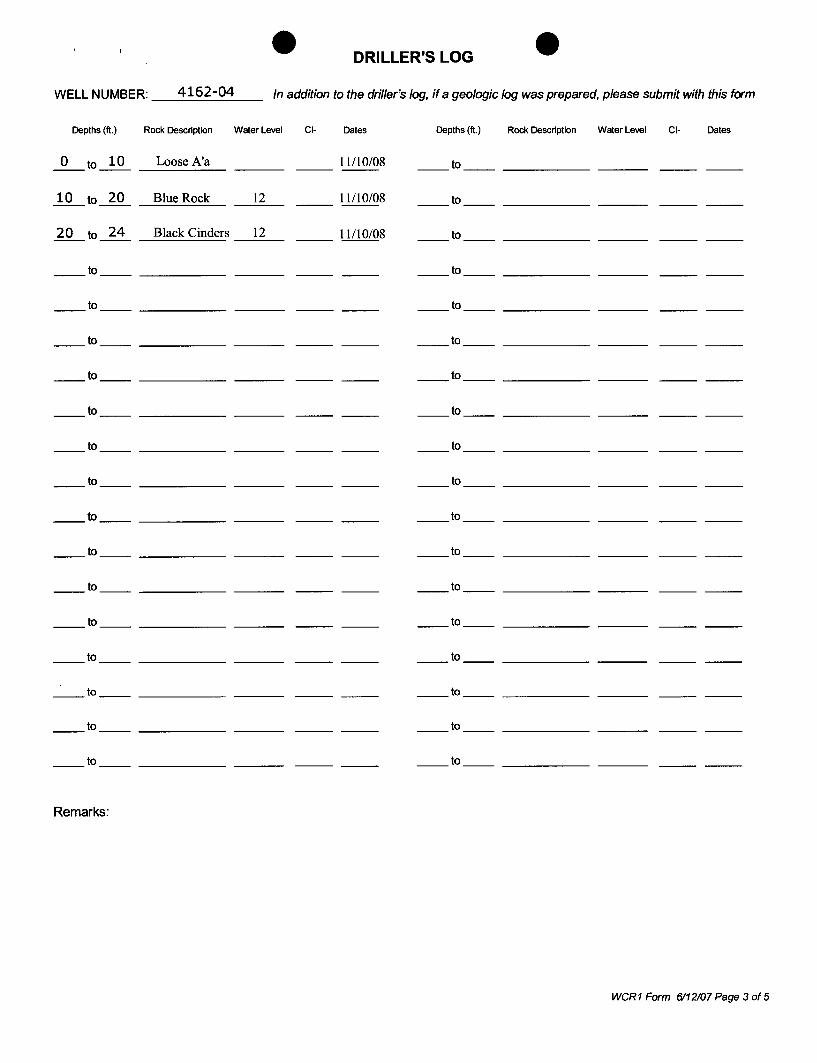
DRILLER'S LOG
WELL NUMBER: __ 4~1~6..::...2--..:-0~4 __ In addition to the driller's log, if a geologic log was prepared, please submit with this form
Depths (ft.) Rock Description Water Level CI- Dates Depths (ft.) Rock Description Water Level CI- Dates
_0_ to ~ __ L_o_o_se_A_'a ___ _ 11110108 __ to __________ _
~to~ Blue Rock 12 11110108 to
1.Lto~ Black Cinders __ 1_2_ to
__ to __________ _ to
__ to __________ _ to
to __ to __________ _
to __ to __________ _
to __ to __________ _
to __ to __________ _
to __ to __________ _
to __ to __________ _
to __ to __________ _
to __ to __________ _
to __ to __________ _
__ to __________ _ __ to __________ _
__ to __________ _ __to __________ _
__ to __________ _ __to __________ _
__ to __________ _ __to __________ _
Remarks:
WeRt Form 6112107 Page 3 of 5
EXAMPLE
Attach photos of completed well and concrete pad
SKETCH OF WELL LOCATION
Lat: 19°36'45"
(Referenced to pennanent landmark, i.e. building, road, fence, etc.) Provide Latitude and Longitude of well referenced to NAD83 to nearest second
weR1 Form 1117106 Page 4 of 5
Well Elevation 'b~ A\ lot. .. btlr \v\~ 4-00
Benchmark Elevation 12.97
Attach photos of completed well and concrete pad showing benchmark location.
I certify that the elevation shown above:
1) Was done in accordance with acceptable surveying practices 2) Is accurate to the nearest 0.01 ft. 3) Is referenced to mean sea level
1639
License No.
January 13, 2009
Date
weR1 Form 1117/08 Page 5 of 5

...,,-.0.':; VI .. lana ..
COMMISSION _WATER RESOURCE MANAGEM~ Department of 1!Ihd and Natural Resources
WELL COMPLETION REPORT - PART I Well Construction
,"...-uctIon.: Plea .. print 111 Ink or type and send oompIeled repart (witt! 1Ittac1l1'nlll'lCB, If appllcalMa) 10 1tIe Ccmmillllioo on Water RMaurca Managamenl, P.O. Box 621, Hcnolulu, HawllII96809. Thill Commiuion may nQt accept Incomplete n!IpDItS. TNs form shall be eubmiI.\vd WIIhin 60 days of !he ~ of WOlle, For awiHmCII .... oonauII !he HlIWAll Well Conslruotlon and I-'ump Imnllllletion St8ndanll or call the RlIgulalion &8nc1l at 517.0225. For updatM to tills form or addtIIc.Inal '"'ormation. pINM villi our wetlctIIa at hUp:JIwww ..... hl.uslc:hIcwrmI
1. state Well No.: 4161-11 Well Name: ;...M:.,:.W-=--..;4.;:.O.;:.1 ______ _
09 JAN 20 A 9: 2
2. Address: P.O. Box 9165, Kailua-Kona, HI 96745 Tax Map Key: 7-3-009:003
~~--------------3. Dr1l11ng Company: Derrlck~s. Well Qrilling & Pump Service
4. Drilling method used dur1ng construction: • Rotary 0 Percussion u Other (describe)
5. Date Well Construction (drillod,cased,grouted) oompleted: .. 11/14/08 AttactI CompkmldDrlllef". Log monlhldlyfyear
6. Was the sub)oct well cored? n Yes • No
7. Step-Drawdown Test completed? • Nu U Ves Attach ttep.orawdown TNt form tf1l1'71t7' 5DfI'7D fbmr)
8. Constant Rate uifer Test cnrnDI4~",!!f?_~.~N~D ~[]!...:Y~e~lS.....,;!!!!~~!!!!!!!!l!~~~~_
Water L.8ve' 0.: 9. IniDai encountered during
IIhouId aliso be .. teet in on lite dI'h,'lt!95l}
10. Just . to eM lnstal,:lat::.::io=n:.:-___ ltii~;;;;~:..:.::::::.-
11. After casing installation (tlis information vtIOUId be bafont any pump w.tJiI are pelfoolled wtIIl ~ng inlblhd)
Chloride: ~ ppm. Tamp8l1llure: ~9 .. 8
now: for IIIIM1rWtl!m to meM S88 ~ the depth to 1M ...,., 1tweI.
12. As-bullt section filled in completely •
13. Photograph of well end concrete pad showing benchmark on concrete pad attached •
14. GPS coordinates provided In deg ....... mlnu .... HCOnda •
15. If a pump is not planned to be Installed, plea8B dB8cribe (below in the remarks section) how well is secured to prevent unauthorized access (example: lockable cover, threaded coupling, etc.)
16. Remarks:
Ucensect Driller (print) _D---,e ... r .... r .... i_c_k_M--.;;.o_r_e_i_r_a ___ _
-.t;1~;/~ 0.57 Lie, No. C-2800 1
Date January 15, 2009 Signature
WCR1 Form fil12/(Jl f'f¥ 1 of 5

12. AS-BUILT WELL SECTION (Please attach as-built if different from diagram provided below)
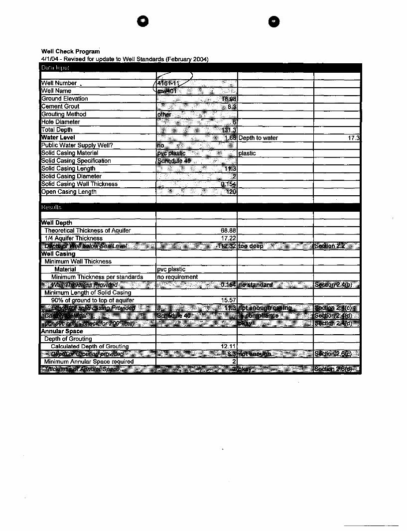
Hole Diameter' 6 in Elevation at top of casing 18.98 ft., msl" \ r (to nearest 0.01 ft.) ----.Lt- __ ---+6*1 Minimum of 2' Radius & 4" Thick Concrete Pad
r:B-en-c-:-h-m-a-r-:-k---I---------------1l..-:::;·1TI: ?'H r Ground Elevation: 16.58 ft., msl 0 Surveyed • Estimated
elevation: //,11/(\\ :;:. 1;.';, .o'-!. '-'-'-l-,----d /I/"'~"-~/I"""''''
16.75 ft., msl"
• (Surveyed to nearest 0.01 ft.)
o (Estimated)
Grouting method: o Positive
displacement (if annular space is less than two inches, attach photo oftremie)
• Other
Total Depth
131.3 ft.
Cement Grout: 8.3 ft. (min. 70% of distance from ground elevation to top of water surface or 500 ft., whichever is less.)
Annular space between hole and casing (1.5" for positive displacement, 3" for other methods):
2 in.
123 ft.
:-.::: :.:-> ""0 ~.: Q)
'~'.: .::' ;. .~::: •••• 4; -",..... ',4. ; .:
::'::. iii :-.,: ~ .: ,,- Q)
•~ :~.': ...J ." ,0 Q; '. ~-• ,4 ••
, ..
Please refer to the HAWAII WELL CONSTRUCTION AND PUMP INSTALLATION STANDARDS to ensure that your as-built is in compliance
with applicable standards.
'~"~: ~ ::' ~ Jf----J Solid Casing: (2!: 90% x (Ground Elev.-Water Level Elev» .. ,. :~;. ~ L ~{-g Length: 11.3 ft.
1:1;: ., .. :::l Nominal Diameter: 2 in. I /".::'. ..::'. e V '-'~ •· ... 4 ~ Wall Thickness: __ ..!0~.~1~5:.:c4~ ______ in.
Bottom Elevation:_--=5:.;c • .::.3 ______ ft., msl
Material: ~ • Crushed Basalt
L-;:=D=Ro=u=n=d=ed=G=ra=v=el=:!--! ~"f-I~<j,;~\-II-~"";&~!lI- v Open Casing: • Perforated
Length: 120
Nominal Oiameter:_~2 _________ in.
o Screen
ft.
"~ ~ Water Level Elevation:
1.68 ft. msl"
(item 11 from page 1)
~ ~ _L-!iii ~ __ +_
"msl = mean sea level
Wall Thickness: 0.154 in.
Bottom Elevation: -114.7 ft., msl
Open Hole:
Length: ____ ~N:.=o:.::n:.=e~ ______ ft.
Diameter: _____________ in.
Bottom Elevation: _________ ft., msl
Solid Casing Material: Carbon Steel: compliant with (check one or more): 0 ANSI/AWWA C200 0 API Spec. 5L o ASTMA53
And compliant with (check one or more): 0 ASTM A242 or A606 0 Type E
o ASTM A139
o Other o Type S 0 Grade B
Stainless Steel: (check one): 0 ASTM A409 (production wells) o ASTM A312 (monitor wells)
ABS Plastic conforming to ASTM F480 and ASTM 01527: (check one) o Schedule 40 o Schedule 80
PVC Plastic conforming to ASTM F480 and (ASTM 01785 or ASTM 02241): (check one): • Schedule 40 0 Schedule 80 0 Schedule 120
Thermoset Plastic: (check one) 0 Filament Wound Resin Pipe conforming to ASTM 02996
o Centrifugally Cast Resin Pipe conforming to ASTM 02997
o Reinforced Plastic Mortar Pressure Pipe conforming to ASTM 03517
o Glass Fiber Reinforced Resin Pressure Pipe conforming to AWWA C950
o PTFE Fluorocarbon Tubing conforming to ASTM 03296
o FEP Fluorocarbon Tubing conforming to ASTM 03296
Open Casing Material: Carbon Steel: compliant with (check one or more): 0 ANSIIAWWA C200 0 API Spec. 5L 0 ASTM A53 0 ASTM A139
And compliant with (check one or more): 0 ASTM A242 or A606 0 Type E 0 Type S 0 Grade B 0 Other
Stainless Steel: (check one): 0 ASTM A409 (production wells) 0 ASTM A312 (monitor wells)
ABS Plastic conforming to ASTM F480 and ASTM 01527: (check one) 0 Schedule 40 0 Schedule 80
PVC Plastic conforming to ASTM F480 and (ASTM 01785 or ASTM 02241): (check one): • Schedule 40 0 Schedule 80 0 Schedule 120
Thermoset Plastic: (check one) o Filament Wound Resin Pipe conforming to ASTM 02996
o Centrifugally Cast Resin Pipe conforming to ASTM 02997
o Reinforced Plastic Mortar Pressure Pipe conforming to ASTM 03517
o Glass Fiber Reinforced Resin Pressure Pipe conforming to AWWA C950
o PTFE Fluorocarbon Tubing conforming to ASTM 03296
o FEP Fluorocarbon Tubing conforming to ASTM 03296
WCR 1 Form 6112107 Page 2 of 5
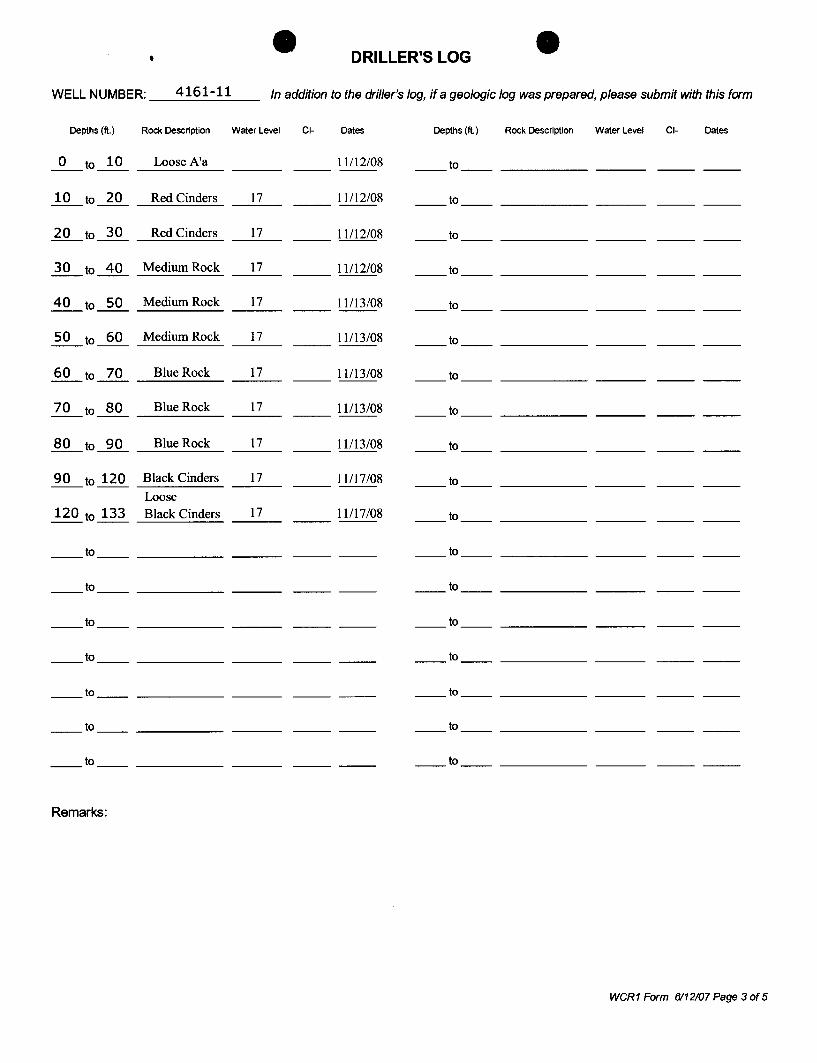
, DRILLER'S LOG
WELL NUMBER: __ 4_1_6=--1_-_1_1 __ In addition to the driller's log, if a geologic log was prepared, please submit with this form
Depths (ft.) Rock Description Water Level CI- Dates Depths (ft.) Rock Description Water Level CI- Dates
0 to 10 Loose A'a 11112/08 to -- -- ---- -- -- ----
10 to 20 Red Cinders 17 11112/08 to ---- -- -- ----
20 to 30 Red Cinders 17 __ 11112/08 to -- -- -- ----
30 to 40 Medium Rock 17 11112/08 to -- ---- -- -- ----
40 to 50 Medium Rock 17 11113/08 to -- ---- -- -- ----
50 to 60 Medium Rock 17 11113/08 to -- -- ---- -- -- ----
60 to 70 Blue Rock 17 11/13/08 to -- ---- -- -- ----
70 to 80 Blue Rock 17 11113/08 to -- -- ---- -- -- ----
80 to 90 Blue Rock 17 11113/08 to ---- -- -- ----
90 to 120 Black Cinders 17 11117/08 to -- ---- -- -- ----Loose
120 to 133 Black Cinders 17 11117/08 to ---- -- -- ----
--to -- ---- --to -- ----
--to -- ---- --to -- ----
--to -- ---- --to -- ----
--to -- ---- --to -- ----
--to -- ---- --to -- ----
--to -- --to --
--to -- --to --
Remarks:
WCR 1 Form 6112107 Page 3 of 5
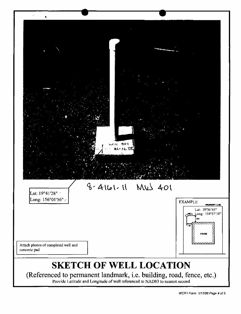
,
. 19°41 '28" -
: 156°01'56"/
Attach photos of completed well and concrete pad
EXAMPLE
Lat: 19°36'45"
SKETCH OF WELL LOCATION (Referenced to permanent landmark, i.e. building, road, fence, etc.)
Provide Latitude and Longitude of well referenced to NAD83 to nearest second
weR1 Form 1117106 Page 4 of 5
-Well Elevation
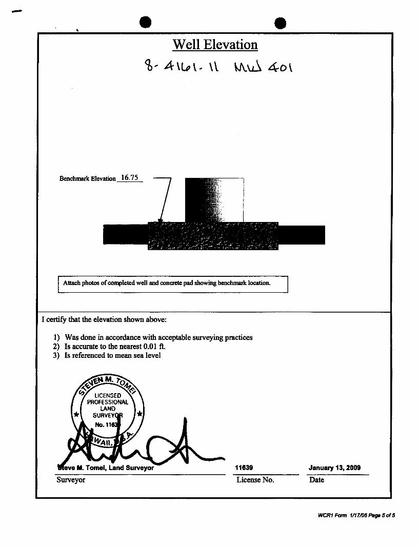
<b .. A \u, \.. \ \ \J\.~ 4-0 \
Benchmark Elevation 16.75
Attach photos of completed well and concrete pad showing benchmark location.
I certify that the elevation shown above:
1 ) Was done in accordance with acceptable surveying practices 2) Is accurate to the nearest 0.01 ft. 3) Is referenced to mean sea level
eve M. Tomei, Land Surveyor 11639
Surveyor License No.
January 13,2009
Date
WCR1 Form 1/17106 Page 50'5
,,"' ... 111: UI naWi:l1I .'or OflidaJ lise Only:
COMMISSION taWATER RESOURCE MANAGEM-=tI bepartment of f!'nd and Natural Resources
WELL COMPLETION REPORT· PART I Well Construction R Ere I \} C n
Inatrucaon.: Plene print In Ink or type and Mnd CM!pIeted report (wiUJ oltoohmoots. I' ",pplable) to the Cummislion en WBlwr Rescurca ManagarnaM, po, Boll 621. Honolulu. HawaI 96809, The Commiwion IT1IIY nut uccvpt irnxlmp.1II repcxtI. ll1I8 form IhatI be sLlbrnltted v,thiIn 60 days 01 the (lO1~ gf WQfk. for 9 2 asslSlStlce. pIee!Ie ocnsuII the Hawaii Well CCll'lAlruclIan and Pump Instatlotion Standards or Q8l1 tlwt Regulation 09 JAN 2tl A : Snmch el 5a7-0zz5. For updates to this fonn or additional Information. pIoasQ visit out webwilll lit hUpJIwww,$IUte,hi.V!J/dr.:I!XmIlI
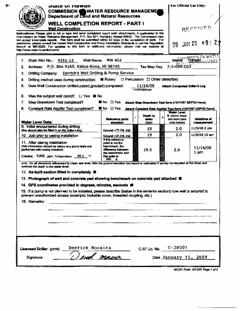
1. State Welt No.: 4161~12 Wetl Nama; MW 402
2. Address: F.'~g,-Box 916~ .. Kallua-Kona, HI 96745
3, Drilling Company: Derrick's Well Ori!!~~gJk Pump.~S_e_rv_ice,-,--_______________ _
4. Drilling method ussd during construcUon: • Rotary 0 P8fCussion 0 Other (describe)
5. Date Well Construction (drtlled,cased,groutocl) completed: 11/14/08" AUllch c~ DrlI ...... Log monChJdaylyeer
6, W8sIhe 6Ubje<:t well cored? [J Yes • No
7. Stap-DrawdownTestcompieted? • No 0 Yes Atl.l:h~nT_farm(11if7""7SOPTDForm)
8. • No 1:1 Yes~ __ ~~~!!!!!]!.!!!!!!l~~~!!;!!!.i!~:!!.!~~~~
Water Lovel Data: 9. Initial encountered during drilling (lhia ~ liiio be filled In on the driller's log)
10. Just rlor to caBin installation
11. After casing installation (1tH Infotmation should bit before tJI1)' pump tnts .,.. performed with C88ing irlstaIIod)
Chloride: 9,~_ ppn, TemporaWrf/: 6R,(}
2.0
2.0
DtdIItIma Gf IT~~
11/51082 pm
11/6108 10 am
11/16/08 1 pm
note: for all oI6V$~ f91enmcwd to m:Hn ua NtW~~hiiliei~~~~.l'7iit;;;::;W;iiiiii.dii tJ4mtrad the dopIlllu tIrfI WBtw 1fMII.
12. As-bullt section filled in completely •
13. Photograph of well and concrete pad .hawlng benchmark on GOl1Cntte pad attached •
14. OPS coordin ..... provided In dog ..... , minutes, HCOnda •
15. If a pump is not planned to be installed, ptease de\lcrlbe (below in the remarks section) how well Is secured to prevBnt unauthorized aocess (example; lockable cover, threaded coupMng. etc.)
18. Remarks:
Llceneed Driller (print) Derrick Moreira
_O~~~ C·S7 Lie. No. __ C_-_2_8_0_0_1 ____ _
Date January 15 ( 2009 Signature
WCR1 Fonn BI1 M17 Pttge 1 of 5
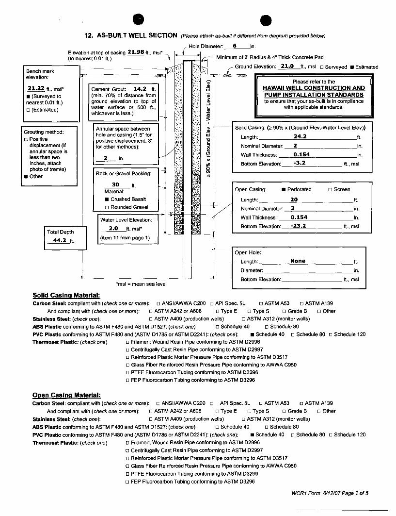
12. AS-BUILT WELL SECTION (Please attach as-built if different from diagram provided below)
Elevation at top of casing 21.98 ft., mSI*l r (to nearest 0.01 ft.) I-- I,r-;-- Minimum of 2' Radius & 4" Thick Concrete Pad
Hole Diameter' 6 in
-.--.b.' ~'H r Ground Elevation: 21.0 ft., msl o Surveyed • Estimate Bench mark 1.·:··:~.:~ -' -q . -, "
elevation: //~, '\lI>.- '1;>.- /I~' ~,
" " 4 •• >' Please refer to the ',6 ••
21.22 ft., msl* 14.2 . '. . '. Q) HAWAII WELL CONSTRUCTION AND Cement Grout: ft. :. ~. ::':> W
• (Surveyed to (min. 70% of distance from .~. ',: ...... OJ PUMP INSTALLATION STANDARDS .:-:;. :: ;- > nearest 0.01 ft.) ground elevation to top of Q) to ensure that your as-built is in compliance
.~ :=: i.{: ...J
o (Estimated) water surface or 500 ft., .... ' ... :u with applicable standards. whichever is less.)
'to.- ."'.-..... . .' ~ I- ',4. • ,4.,
;.; Co': , :.:-- :.!'. Annular space between .;. ',:
f~'~: ::> Solid Casing: (2 90% x (Ground Elev.-Water Level Elev»
Grouting method: Q)
hole and casing (1.5" for :~::;: w 24.2 o Positive positive displacement, 3" rf: ~:;; "0 Length: ft.
displacement (if c
for other methods): '''' ., ::;, Nominal Diameter: 2 in. annular space is V :6:" :~: : !:!
;':':4 ~'. :4 Q. Wall Thickness: 0.154 in. less than two 2 v .:'::. in. :. '~:. x inches, attach ~'.': A. '.: ?f. Bottom Elevation: -3.2 ft., msl photo oftremie) - i-- 0
Rock or Gravel Packing: m • Other AI
30 f i ft. I-
~ Material: ~
Open Casing: • Perforated o Screen
• Crushed Basalt i,f Length: 20 o Rounded Gravel V Nominal Diameter: 2
'" 9-
"I Wall Thickness: 0.154 Water Level Elevation:
2.0 ft. msl* Bottom Elevation: -23.2 Total Depth 1_'-- ~ ~ - f-
44.2 ft. (item 11 from page 1)
Open Hole:
Length: None Diameter:
L-- Bottom Elevation: *msl = mean sea level
Solid Casing Material: Carbon Steel: compliant with (check one or more): 0 ANSIIAWWA C200 0 API Spec. 5L o ASTMA53 o ASTMA139
o Other And compliant with (check one or more): 0 ASTM A242 or A606 0 Type E o Type S 0 Grade B
Stainless Steel: (check one): 0 ASTM A409 (production wells) o ASTM A312 (monitor wells)
ABS Plastic conforming to ASTM F480 and ASTM D1527: (check one) 0 Schedule 40 0 Schedule 80
ft.
in.
in.
ft., msl
ft.
in.
ft., msl
PVC Plastic conforming to ASTM F480 and (ASTM D1785 or ASTM D2241): (check one): • Schedule 40 0 Schedule 80 0 Schedule 120
Thermoset Plastic: (check one) 0 Filament Wound Resin Pipe conforming to ASTM 02996
o Centrifugally Cast Resin Pipe conforming to ASTM D2997
o Reinforced Plastic Mortar Pressure Pipe conforming to ASTM D3517
o Glass Fiber Reinforced Resin Pressure Pipe conforming to AWWA C950
o PTFE Fluorocarbon Tubing conforming to ASTM D3296
o FEP Fluorocarbon Tubing conforming to ASTM D3296
Open Casing Material: Carbon Steel: compliant with (check one or more): 0 ANSIIAWWA C200 0 API Spec. 5L 0 ASTM A53 0 ASTM A139
And compliant with (check one or more): 0 ASTM A242 or A606 0 Type E 0 Type S 0 Grade B 0 Other
Stainless Steel: (check one): 0 ASTM A409 (production wells) 0 ASTM A312 (monitor wells)
ABS Plastic conforming to ASTM F480 and ASTM D1527: (check one) 0 Schedule 40 0 Schedule 80
PVC Plastic conforming to ASTM F480 and (ASTM D1785 or ASTM D2241): (check one): • Schedule 40 0 Schedule 80 0 Schedule 120
Thermoset Plastic: (check one) o Filament Wound Resin Pipe conforming to ASTM D2996
o Centrifugally Cast Resin Pipe conforming to ASTM D2997
o Reinforced Plastic Mortar Pressure Pipe conforming to ASTM D3517
o Glass Fiber Reinforced Resin Pressure Pipe conforming to AWWA C950
o PTFE Fluorocarbon Tubing conforming to ASTM D3296
o FEP Fluorocarbon Tubing conforming to ASTM D3296
WCR 1 Form 6112107 Page 2 of 5
d
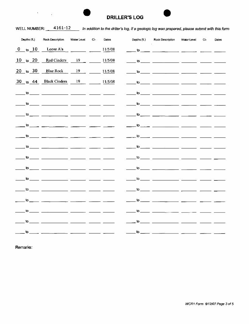
DRILLER'S LOG
WELL NUMBER: __ 4_1_6_1_-_1_2 __ In addition to the driller's log, if a geologic log was prepared, please submit with this form
Depths (ft.) Rock Description Water Level CI- Dates Depths (ft.) Rock Description Water Level CI- Dates
_O_to ~ _.=Lo~os_e_A_'_a ___ _ 1115/08 __ to __________ _
~ to ~ Red Cinders 19 1115/08 to
~ to ~ Blue Rock 19 __ 1115/08 __ to __________ _
~ to ~ Black Cinders 19 1115/08 __ to __________ _
__ to __________ _ __ to __________ _
__ to ___________ _ __to __________ _
__ to __________ _ __to __________ _
__ to ___________ _ __to __________ _
__ to __________ _ __to __________ _
__ to __________ _ __to __________ _
__ to __________ _ __to __________ _
__ to __________ _ __to __________ _
__ to __________ _ __to __________ _
__ to __________ _ __to __________ _
__ to __________ _ to
__ to __________ _ __to __________ _
__ to __________ _ to
to to
Remarks:
WCR 1 Form 6112107 Page 3 of 5
Attach photos of completed well and concrete pad
EXAMPLE
SKETCH OF WELL LOCATION (Referenced to permanent landmark, i.e. building, road, fence, etc.)
Provide Latitude and Longitude of well referenced to NAD83 to nearest second
weR1 Form 1117106 Page 4 of 5
Well Elevation
'6, A\lo\ .. \1- \J\.~ 4o~
Benchmark Elevation 21.22
Attach photos of completed well and concrete pad showing benchmark location.
I certify that the elevation shown above:
1) Was done in accordance with acceptable surveying practices 2) Is accurate to the nearest 0.01 ft. 3) Is referenced to mean sea level
Surveyor License No.
January 13. 2009
Date
weR1 Form 1/17/06 Page 5 of 5
, LINDA LINGLE
GOVERNOR OF HAWAII
Ref:4162-01.wap
Mr. Derrick Moreira Derrick's Well Drilling P.O. Box 2187 Keeau, HI 96749
Dear Mr. Moreira:
STATE OF HAWAII DEPARTMENT OF LAND AND NATURAL RESOURCES
COMMISSION ON WATER RESOURCE MANAGEMENT P.O. BOX 621
HONOLULU, HAWAII 96809
Well Abandonment Permit MW 300, 301 & 302 Wells (Well No. 4162-01, 4162-02, 4162-03)
LAURA H. THIELEN CHAIRPERSON
MEREDITH J. CHING JAMES A. FRAZIER NEAL S. FUJIWARA
/
CHIYOME L. FUKINO, M.D. DONNA FAY K KIYOSAKI, P.E. LAWRENCE H. MilKE, M.D., J.D.
KEN C. KAWAHARA, P.E. DEPUTY DIRECTOR
October 23,2008
Enclosed are two (2) copies of your approved Well Abandonment Permit for the captioned welles) which authorizes well abandonment/sealing activities. As part of the Chairperson's approval, the following special conditions were added and are part of your permit under Permit Condition 7:
Special Conditions
1. none
To validate your permit, please sign both permit originals and return one for our files.
IMPORTANT - The contractor is responsible for all conditions of the permit. This includes ensuring that the submission of a completed Well Abandonment Report form (enclosed) within sixty (60) days after the well construction work is completed. Be advised that you may be subject to fines of up to $5000 per day for any violations of your permit conditions.
If you have any questions, please call Ryan Imata of the Commission staff at 587-0255.
Sincerely,
-K~;f}/;jLEN Chairperson
Enclosures
c: Discovery Land Co. National Park Service USGS Hawaii Department of Water Supply
- o WELL CONSTRUCTION PERMIT TO ABANDON/SEAL .J
MW 300. 301 & 302 Wells. Well No. 4162-01. 4162-02. 4162-03
In accordance with Department of Land and Natural Resources, Commission on Water Resource Management's Administrative Rules, Section 13-168, entitled "Water Use, Wells, and Stream Diversion Works", this document permits the abandonment/sealing ofMW 300, 301 & 302 Wells (Well No. 4162-01, 4162-02, 4162-03), Hawaii, TMK 7-3-009:003, subject to the Hawaii Well Construction & Pump Installation Standards (HWCPIS - February 2004) which include but are not limited to the following conditions:
1. The Chairperson of the Commission on Water Resource Management, P.O. Box 621, Honolulu, Hawaii 96809, shall be notified in writing before any work covered by this permit commences.
2. This permit shall be prominently displayed, or made available, at the site of construction work until work is completed.
3. The well construction permit application is incorporated into this permit by reference and is subject to the HWCPIS. If the HWCPIS are not followed and as a consequence water is wasted or contaminated, a lien on the property may result.
4. The Well Abandonment Report form shall be submitted to the Commission on Water Resource Management within sixty (60) days after completion of the work. Please contact staff or visit our website at www.state.hi.us/dlnr/cwrm for the current form.
5. The permittee shall comply with all applicable laws, rules, and ordinances.
6. The sealing shall be completed within two (2) years.
7. Special conditions in the attached cover transmittal letter are incorporated herein by reference.
Date of Approval: October 23, 2008 Expiration Date: None
I have read the conditions and terms of this permit and understand them. I accept and agree to meet these conditions as a prerequisite and underlying condition of my ability to proceed and understand that I shall not commence work until I have signed, dated, and returned the permit to the Commission. I understand that this permit is not to be transferred to any other entity. I also understand that non-compliance with any permit condition may be grounds for revocation and fines of up to $5,000 per day starting from the permit date of approval.
Contractor's Signature: __________ _ License #.28001 __ _ Date: ----------Printed Name, ________________ _ Firm or Title: -------------Please sign both copies of this permit, return one to the Chairperson, and retain the other for your records.
+ I
., LINDA LINGLE
GOVERNOR OF HAWAII LAURA H. THIELEN
CHAIRPERSON
MEREDITH J. CHING JAMES A. FRAZIER NEAL S. FUJIWARA
CHIYOME L. FUKINO, M.D.
/'
DONNA FAY K KIYOSAKI, P.E. . LAWRENCE H. MilKE, M.D., J.D./
KEN C. KAWAHARA, P.E. STATE OF HAWAII
DEPARTMENT OF LAND AND NATURAL RESOURCES COMMISSION ON WATER RESOURCE MANAGEMENT
P.O. BOX 621 HONOLULU, HAWAII 96809
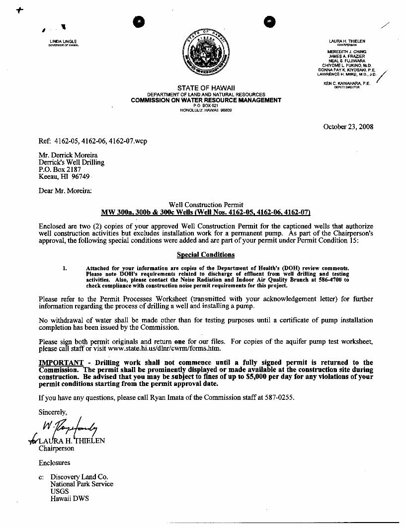
Ref: 4162-05,4162-06, 4162-07.wcp
Mr. Derrick Moreira Derrick's Well Drilling P.O. Box 2187 Keeau, III 96749
Dear Mr. Moreira:
Well Construction Permit MW 300a, 300b & 300c Wells <Well Nos. 4162-05, 4162-06, 4162-07>
DEPUTY DIRECTOR
October 23, 2008
Enclosed are two (2) copies of your approved Well Construction Permit for the captioned wells that a\lthorize well construction activities but excludes installation work for a permanent pump. As part of the Chairperson's approval, the following special conditions were added and are part of your permit under Permit Condition 15:
Special Conditions
1. Attached for your information are copies of the Department of Health's (DOH) review comments. Please note DOH's requirements related to discharge of effluent from well drilling and testing activities. Also, please contact the Noise Radiation and Indoor Air Quality Branch at 586-4700 to check compliance with construction noise permit requirements for this project.
Please refer to the Permit Processes Worksheet (transmitted with your acknowledgement letter) for further information regarding the process of drilling a well and installing a pump.
No withdrawal of water shall be made other than for testing purposes until a certificate of pump installation completion has been issued by the Commission.
Please sign both permit originals and return one for our files. For copies of the aquifer pump test worksheet, please call staff or visit www.state.hi.us/dlnr/cwrmlforms.htm.
IMPORTANT - Drilling work shall not commence until a fully signed permit is returned to the Commission. The permit shall be prominently displayed or made available at the construction site during construction. Be advised that you may be subject to fines of up to $5,000 per day for any violations of your permit conditions starting from the permit approval date.
If you have any questions, please call Ryan Imata of the Commission staff at 587-0255.
Sincerely,
;::~iEN Chairperson
Enclosures
c: Discovery Land Co. National Park Service USGS HawaiiDWS
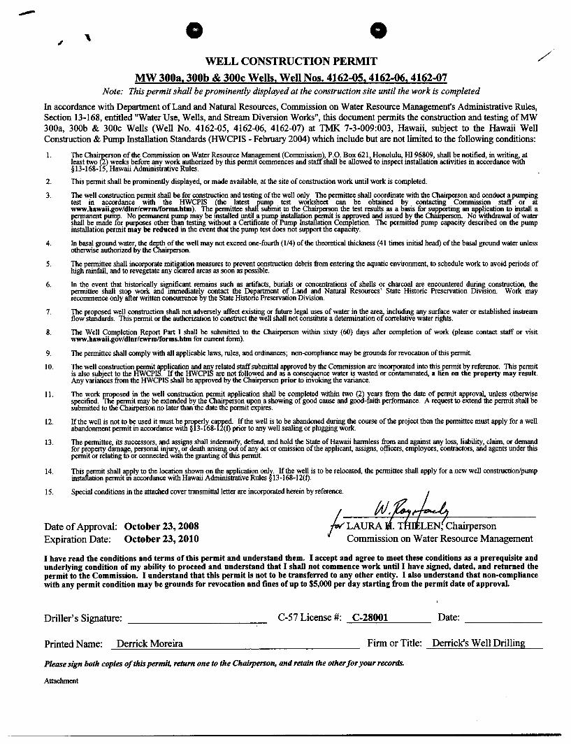
, WELL CONSTRUCTION PERMIT
MW 3003, 300b & 300c Wells, Well Nos. 4162-05, 4162-06, 4162-07 Note: This permit shall be prominently displayed at the construction site until the work is completed
In accordance with Department of Land and Natural Resources, Commission on Water Resource Management's Administrative Rules, Section 13-168, entitled "Water Use, Wells, and Stream Diversion Works", this document permits the construction and testing ofMW 300a, 300b & 300c Wells (Well No. 4162-05, 4162-06, 4162-07) at TMK 7-3-009:003, Hawaii, subject to the Hawaii Well Construction & Pump Installation Standards (HWCPIS - February 2004) which include but are not limited to the following conditions:
1.
2.
3.
4.
5.
6.
7.
8.
9.
10.
II.
12.
14.
The Chaif£erson of the Commission on Water Resource Management (Commission), P.O. Box 621, Honolulu, HI 96809, shall be notified, in writing, at least two (2) weeks before any work authorized by this permit commences and staff shall be allowed to inspect installation activities in accordance with §13-168-15, Hawaii Administrative Rules.
This permit shall be prominently displayed, or made available, at the site of construction work until work is completed.
The well construction permit shall be for construction and testing of the well only. The permittee shall coordinate with the Chairperson and conduct a pumping test in accordance with the HWCPIS (the latest rump test worksheet can be obtained by contacting Commission staff or at www.hawaii.gov/dlnr/cwrmlforms.htm). The permittee shal sulimit to the Chairperson the test results as a basis for supporting an application to install a permanent pump. No permanent pump may be mstalled until a pUIl1J> installation permit is approved and issued by the Charrperson. No withdrawal of water shall be made for purposes other than testing without a Certificate of Pump Installation Completion. The permitted pump capacity described on the pump installation permit may be reduced in the event that the pump test does not support the capacity.
In basal ground water, the depth of the well may not exceed one-fourth (114) of the theoretical thickness (41 times initial head) of the basal ground water unless otherwise authorized by the Chairperson.
The permittee shall incorporate mitigation measures to prevent construction debris from entering the aquatic environment, to schedule work to avoid periods of high rainfall, and to revegetate any cleared areas as soon as possible.
In the event that historically significant remains such as artifacts, burials or concentrations of shells or charcoal are encountered during construction, the permittee shall stop work and immediately contact the Department of Land and Natural Resources' State Historic Preservation DiVIsion. Work may recommence only after written concurrence by the State Histone Preservation Division.
The proposed well construction shall not adversely affect existing or future legal uses of water in the area, including any surface water or established instream flow standards. This permit or the authorization to construct the well shall not constitute a determination of correlative water rights.
The Well Completion Report Part I shall be submitted to the Chairperson within sixty (60) days after completion of work (please contact staff or visit www.hawaii.gov/dlnr/cwrmlforms.htm for current form).
The permittee shall comply with all applicable laws, rules, and ordinances; non-compliance may be grounds for revocation of this permit.
The well construction permit application and any related staff submittal approved by the Commission are incorporated into this permit by reference. This permit is also subject to the HWCPIS. If the HWCPIS are not followed and as a consequence water is wasted or contaminated, a lien on the property may result. Any variances from the HWCPIS shall be approved by the Chairperson prior to invoking the variance.
The work proposed in the well construction permit application shall be completed within two (2) years from the date of permit approval, unless otherwise specified. The permit may be extended by the Chairperson upon a showing of good cause and good-faith performance. A request to extend the permit shall be submitted to the Chairperson no later than the date the permit expires.
If the well is not to be used it must be prorerly capped. If the well is to be abandoned during the course of the project then the permittee must apply for a well abandonment permit in accordance with § 3-168-l2(f) prior to any well sealing or plugging work.
The permittee, its successors, and assigns shall indemnify, defend, and hold the State of Hawaii harmless from and against any loss, liability, claim, or demand for property damage, personal injury, or death arising out of any act or omission of the applicant, assigns, officers, employees, contractors, and agents under this permit or relating to or connected with the granting of this permit. .
This permit shall apply to the location shown on the application only. If the well is to be relocated, the permittee shall apply for a new well construction/pump insta11ation permit m accordance with Hawaii Administrative Rules § 13-168-12( f).
15 Spo<Uol """""'" ;n "'0 """""" """' ..... """"" = - horeio "rem-. 1tJ. g.,~ Date of Approval: October 23, 2008 f; LAURA if. T~Chairperson Expiration Date: October 23,2010 Commission on Water Resource Management
I have read the conditions and terms of this permit and understand them. I accept and agree to meet these conditions as a prerequisite and underlying condition of my ability to proceed and understand that I shall not commence work until I have signed, dated, and returned the permit to the Commission. I understand that this permit is not to be transferred to any other entity. I also understand that non-compliance with any permit condition may be grounds for revocation and fines of up to $5,000 per day starting from the permit date of approval.
Driller's Signature: C-S7 License #: C-28001 --=:...=:::.::c::.::... ___ _ Date:
Printed Name: Derrick Moreira Firm or Title: Derrick's Well Drilling
Please sign both copies of this permit, return one to the Chairperson, and retain the other for your records.
Attachment
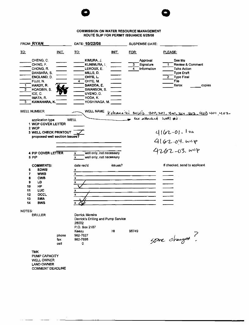
FROM: RYAN
o COMMISSION ON WATER RESOURCE MANAGEMENT
ROUTE SLIP FOR PERMIT ISSUANCE 6/25/08
DATE: 10/22/08 SUSPENSE DATE:
o
PLEASE:
See Me CHENG, C. CHING, F. CHONG,R. DANBARA, S. ENGLAND, D. FUJII, N.
KIMURA, J. KUNIMURA, I. LEROUX, E. MILLS, D. OHYE, L.
Approval -3-Signature -1-Review & Comment
-1-HARDY, R. \i -2-HOAGBIN, S.
ICE, C. IMATA, R.
-3- KAWAHARA, K.==
-4-0HYE,M. SAKODA, E. SWANSON, S. UYENO, D. YODA,K. YOSHINAGA, M.
-4-lnforrnation Take Action --Type Draft -2-Type Final --File
Xerox copies
WELL NUMBER ~ NAME It O~AMP.;~ !\AW's ;z,oO,'UJI, ~bO, 3P' So~, i.{()fJ, «-{Vi ,'-\ O-Z-
application type WELL ----_____ .. ~ ~\\t..~ w-eAI '4\-S' . 1 WCP COVER LETTER 2WCP 3 WELL CHECK PRINTOUT =z:
proposed well section issues?
4 PIP COVER LETTER 5 PIP
COMMENTS: 6 SDWB 7 WWB 8 CWB 9 LD
10 HP 11 LUC 12 OCCL 13 SMA 14 BWS
NOTES: DRILLER
TMK
phone fax cell
PUMP CAPACITY WELL OWNER LANDOWNER COMMENT DEADLINE
x well only, not necessary x well only, not necessary
date rec'd x x x xl' v x x
I
Derrick Moreira
issues?
Derrick's Drilling and Pump Service 28002 P.O. Box 2187 Keeau 982-7627 982-7698
o
HI 96749
~ 1(P1.,-01. t 0"-
~ { lP'l..- -0'-1. IN u~
~~?..- -03. wOf
if checked, send to applicant
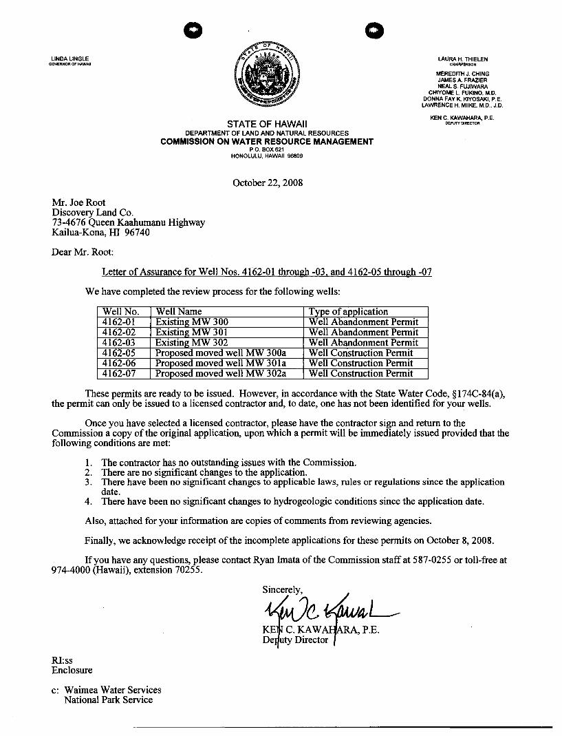
LINDA LINGLE GOVERNOR OF HAWAII
Mr. Joe Root Discovery Land Co.
o o
STATE OF HAWAII DEPARTMENT OF LAND AND NATURAL RESOURCES
COMMISSION ON WATER RESOURCE MANAGEMENT P.O. BOX 621
HONOLULU, HAWAII 96809
October 22, 2008
73-4676 Queen Kaahumanu Highway Kailua-Kona; HI 96740
Dear Mr. Root:
LAURA H. THIELEN CHAIRPERSON
MEREDITH J. CHING JAMES A FRAZIER NEAL S. FUJIWARA
CHIYOME L. FUKINO, M.D. DONNA FAY K KIYOSAKI, P.E. LAWRENCE H. MilKE, M.D., J.D.
KEN C. KAWAHARA P.E. DEPUTY DIRECTOR
Letter of Assurance for Well Nos. 4162-01 through -03, and 4162-05 through -07
We have completed the review process for the following wells:
Well No. Well Name Type of application 4162-01 Existing MW 300 Well Abandonment Permit 4162-02 Existing MW 301 Well Abandonment Permit 4162-03 Existing MW 302 Well Abandonment Permit 4162-05 Proposed moved well MW 300a Well Construction Permit 4162-06 Proposed moved well MW 301a Well Construction Permit 4162-07 Proposed moved well MW 302a Well Construction Permit
These permits are ready to be issued. However, in accordance with the State Water Code, § 174C-84(a), the permit can only be issued to a licensed contractor and, to date, one has not been identified for your wells.
Once you have selected a licensed contractor, please have the contractor sign and return to the Commission a copy of the original application, upon which a permit will be immediately issued provided that the following conditions are met:
1. The contractor has no outstanding issues with the Commission. 2. There are no significant changes to the application. 3. There have been no significant changes to applicable laws, rules or regulations since the application
date. 4. There have been no significant changes to hydrogeologic conditions since the application date.
Also, attached for your information are copies of comments from reviewing agencies.
Finally, we acknowledge receipt of the incomplete applications for these permits on October 8, 2008.
If you have any questions, please contact Ryan Imata of the Commission staff at 587-0255 or toll-free at 974-4000 (Hawaii), extension 70255.
RI:ss Enclosure
c: Waimea Water Services National Park Service
S~inCerelY' (Z.*~L KE C.KAW ,P.E. De uty Director
LINDA LINGLE GOVERNOR OF HAWAII
o o
STATE OF HAWAII DEPARTMENT OF LAND AND NATURAL RESOURCES
COMMISSION ON WATER RESOURCE MANAGEMENT P.o. BOX 621
HONOLULU, HAWAII 96809
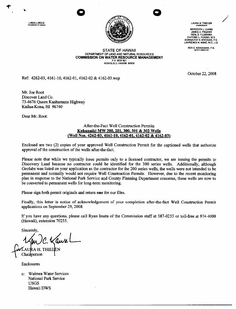
Ref: 4262-03,4161-10,4162-01,4162-02 & 4162-03.wcp
Mr. Joe Root Discover Land Co. , 73-4676 Queen Kaahumanu Highway Kailua-Kona, HI 96740
Dear Mr. Root:
After-the-Fact Well Construction Permits Kohanaiki MW 200, 201, 300, 301 & 302 Wells
(Well Nos. 4262-03,4161-10,4162-01,4162-02 & 4162-03)
LAURA H. THIELEN CHAIRPERSON
MEREDITH J. CHING JAMES A. FRAZIER NEAL S. FUJIWARA
CHIYOME l. FUKINO, M.D. DONNA FAY K KIYOSAKI, P.E. LAWRENCE H. MilKE, M.D., J.D.
KEN C. KAWAHARA, P.E. DEPUTY DIRECTOR
October 22, 2008
Enclosed are two (2) copies of your approved Well Construction Permit for the captioned wells that authorize approval of the construction of the wells after-the-fact.
Please note that while we typically issue permits only to a licensed contractor, we are issuing the permits to Discovery Land because no contractor could be identified for the 300 series wells. Additionally, although Geolabs was listed on your application as the contractor for the 200 series wells, the wells were not intended to be permanent and normally would not require Well Construction Permits. However, due to the recent monitoring plan in response to the National Park Service and County Planning Department concerns, these wells are now to be converted to permanent wells for long-term monitoring.
Please sign both permit originals and return one for our files.
Finally, this letter is notice of acknowledgement of your completion after-the-fact Well Construction Permit applications on September 29,2008.
If you have any questions, please call Ryan Imata of the Commission staff at 587-0255 or toll-free at 974-4000 (Hawaii), extension 70255.
s~incetJe. t~ L Cvr.A H. THIE N
\ . Chai erson
Enclosures
c: Waimea Water Services National Park Service USGS HawaiiDWS
/
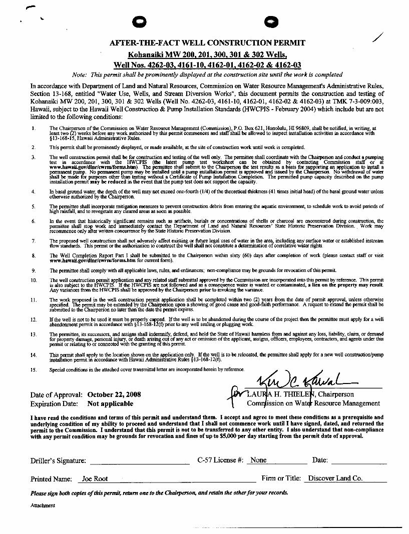
o o AFTER-THE-FACT WELL CONSTRUCTION PERMIT
Kohanaiki MW 200, 201, 300, 301 & 302 Wells, Well Nos. 4262-03,4161-10,4162-01,4162-02 & 4162-03
Note: This permit shall be prominently displayed at the construction site until the work is completed
/
In accordance with Department of Land and Natural Resources, Commission on Water Resource Management's Administrative Rules, Section 13-168, entitled "Water Use, Wells, and Stream Diversion Works", this document permits the construction and testing of Kohanaiki MW 200,201,300,301 & 302 Wells (Well No. 4262-03, 4161-10, 4162-01, 4162-02 & 4162-03) at TMK 7-3-009:003, Hawaii, subject to the Hawaii Well Construction & Pump Installation Standards (HWCPIS - February 2004) which include but are not limited to the following conditions:
I.
2.
3.
4.
5.
6.
7.
8.
9.
10.
II.
12.
13.
14.
15.
The ChaiIP-erson of the Commission on Water Resource Management (Commission), P.O. Box 621, Honolulu, HI 96809, shall be notified, in writing, at least two (2) weeks before any work authorized by this permit commences and staff shall be allowed to inspect installation activities in accordance with §13-168-15, Hawaii Administrative Rules.
This permit shall be prominently displayed, or made available, at the site of construction work until work is completed.
The well construction permit shall be for construction and testing of the well only. The permittee shall coordinate with the Chairperson and conduct a pumping test in accordance with the HWCPIS (the latest rump test worksheet can be obtained by contacting Commission staff or at www.hawaii.gov/dlnr/cwrmlforms.htm). The ~ittee shal sutimit to the Chairperson the test results as a basis for supporting an application to install a permanent pump. No permanent pump may be mstalled until a pump installation permit is approved and issued by the Chauperson. No withdrawal of water shall be made for purposes other than testing without a Certificate of Pump Installation Completion. The permitted pump capacity described on the pump installation permit may be reduced in the event that the pump test does not support the capacity.
In basal ground water, the depth of the well may not exceed one-fourth (l/4) of the theoretical thickness (41 times initial head) of the basal ground water unless otherwise authorized by the Chairperson.
The permittee shall incorporate mitigation measures to prevent construction debris from entering the aquatic environment, to schedule work to avoid periods of high rainfall, and to revegetate any cleared areas as soon as possible.
In the event that historically significant remains such as artifacts, burials or concentrations of shells or charcoal are encountered during construction, the permittee shall stop work and immediately contact the Department of Land and Natural Resources' State Historic Preservation DiVIsion. Work may recommence only after written concurrence by the State Histonc Preservation Division.
The proposed well construction shall not adversely affect existing or future legal uses of water in the area, including any surface water or established instream flow standards. This permit or the authorization to construct the well shall not constitute a determination of correlative water rights.
The Well Completion Report Part I shall be submitted to the Chairperson within sixty (60) days after completion of work (please contact staff or visit www.hawaii.gov/dlnr/cwrmlforms.htm for current form).
The permittee shall comply with all applicable laws, rules, and ordinances; non-compliance may be grounds for revocation of this permit.
The well construction permit application and any related staff submittal approved by the Commission are incorporated into this permit by reference. This pennit is also subject to the HWCPIS. If the HWCPIS are not followed and as a consequence water is wasted or contaminated, a lien on the property may result. Any variances from the HWCPIS shall be approved by the Chairperson prior to invoking the variance.
The work proposed in the well construction permit application shall be completed within two (2) years from the date of permit approval, unless otherwise specified. The permit may be extended by the Chairperson upon a showing of good cause and good-faith performance. A request to extend the permit shall be submitted to the Chairperson no later than the date the permit expires.
If the well is not to be used it must be prorerly capped. If the well is to be abandoned during the course of the project then the permittee must apply for a well abandonment permit in accordance with § 3-168-12(f) prior to any well sealing or plugging work.
The permittee, its successors, and assigns shall indemnify, defend, and hold the State of Hawaii harmless from and against any loss, liability, claim, or demand for property damage, personal injury, or death arising out of any act or omission of the applicant, assigns, officers, employees, contractors, and agents under this permit or relating to or connected WIth the granting of this permit.
This permit shall apply to the location shown on the application only. If the well is to be relocated, the permittee shall apply for a new well construction/pump installation permit m accordance with Hawaii Administrative Rules § 13-I 68-12(f).
Special conditions in the attached cover transmittaIletter are incorporated herein by reference.
Date of Approval: October 22, 2008 Expiration Date: Not applicable
~LA 1 Com
, Chairperson Resource Management
I have read the conditions and terms of this permit and understand them. I accept and agree to meet these conditions as a prerequisite and underlying condition of my ability to proceed and understand that I shall not commence work until I have signed, dated, and returned the permit to the Commission. I understand that this permit is not to be transferred to any other entity. I also understand that non-compliance with any permit condition may be grounds for revocation and fines of up to $5,000 per day starting from the permit date of approval.
Driller's Signature: C-S7 License #: None -=-:...::..:::"'------- Date:
Printed Name: Joe Root Finn or Title: Discover Land Co.
Please sign both copies of this permit, return one to the Chairperson, and retain the other for your records.
Attachment
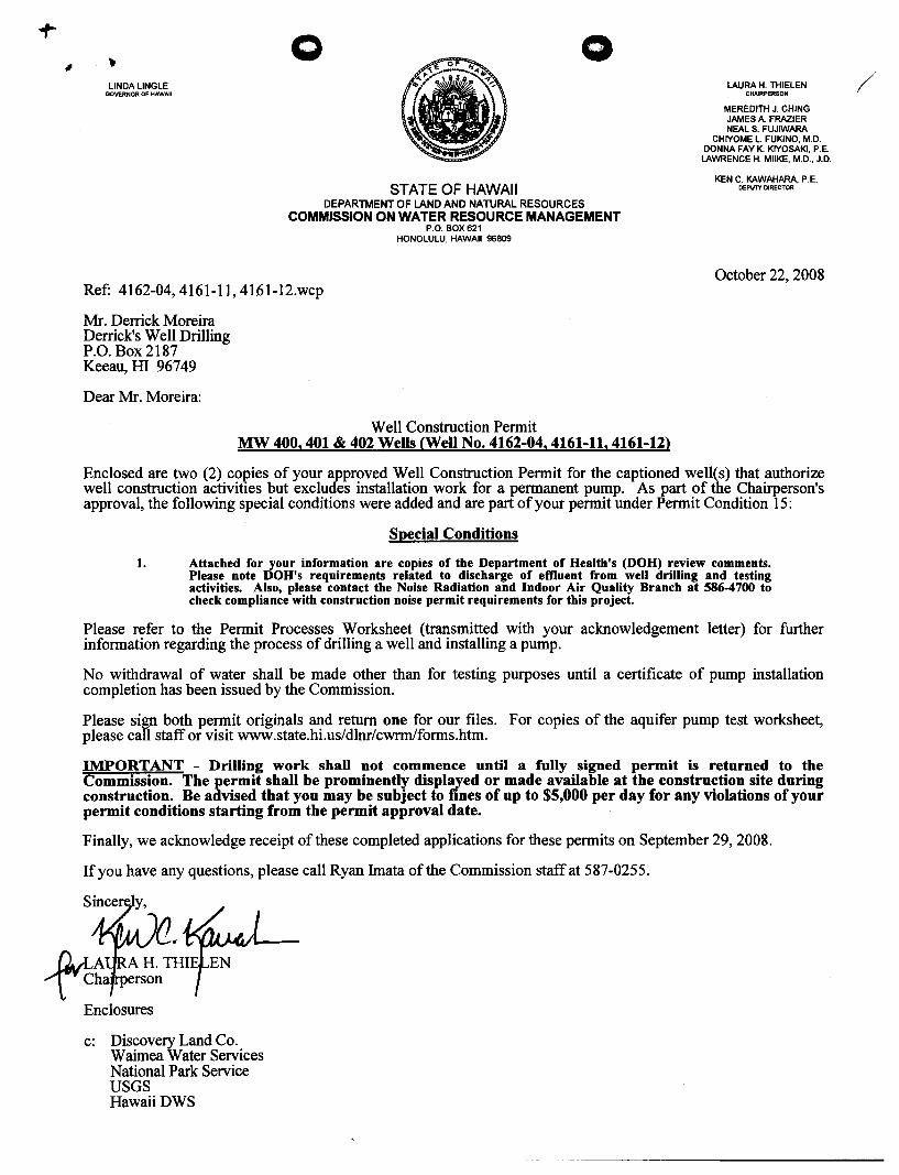
LINDA LINGLE GOVERNOR OF HAWAII
o o
STATE OF HAWAII DEPARTMENT OF LAND AND NATURAL RESOURCES
COMMISSION ON WATER RESOURCE MANAGEMENT P.O. BOX 621
HONOLULU, HAWAII 96809
Ref: 4162-04,4161-11, 4161-12.wcp
Mr. Derrick Moreira Derrick's Well Drilling P.O. Box2187 Keeau, ill 96749
Dear Mr. Moreira:
Well Construction Permit MW 400, 401 & 402 Wells <Well No. 4162-04,4161-11,4161-12)
LAURA H. THIELEN CHAIRPERSON
MEREDITH J. CHING JAMES A. FRAZIER NEAL S. FUJIWARA
CHIYOME L FUKlNO, M.D. DONNA FAY K KIYOSAKI, P.E.
LAWRENCE H. MilKE, M.D., J.D.
KEN C. KAWAHARA, P.E. DEPUTY DIRECTOR
October 22, 2008
Enclosed are two (2) cOllies of your approved Well Construction Permit for the captioned welles) that authorize well construction activities but excludes installation work for a permanent pump. As part of the Chairperson's approval, the following special conditions were added and are part of your permit under Permit Condition 15:
Special Conditions
1. Attached for your information are copies of the Department of Health's (DOH) review comments. Please note DOH's requirements related to discharge of effluent from well drilling and testing activities. Also, please contact the Noise Radiation and Indoor Air Quality Branch at 586-4700 to check compliance with construction noise permit requirements for this project.
Please refer to the Permit Processes Worksheet (transmitted with your acknowledgement letter) for further information regarding the process of drilling a well and installing a pump.
No withdrawal of water shall be made other than for testing purposes until a certificate of pump installation completion has been issued by the Commission.
Please sign both permit originals and return one for our files. For copies of the aquifer pump test worksheet, please call staff or visit www.state.hi.us/dlnr/cwrmlforms.htm.
IMPORTANT - Drilling work shall not commence until a fully signed permit is returned to the Commission. The permit shall be prominently displayed or made available at the construction site during construction. Be advised that you may be subject to fines of up to $5,000 per day for any violations of your permit conditions starting from the permit approval date.
Finally, we acknowledge receipt of these completed applications for these permits on September 29,2008.
If you have any questions, please call Ryan Imata of the Commission staff at 587-0255 .
..avLA ...... "t. Cha
Enclosures
c: Discovery Land Co. Waimea Water Services National Park Service USGS HawaiiDWS
/
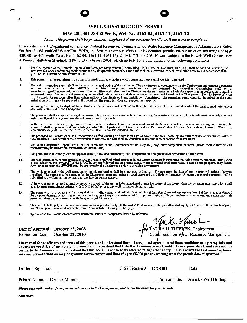
- o o WELL CONSTRUCTION PERMIT
MW 400. 401 & 402 Wells. Well No. 4162-04. 4161-11. 4161-12 Note: This permit shall be prominently displayed at the construction site until the work is completed
In accordance with Department of Land and Natural Resources, Commission on Water Resource Management's Administrative Rules, Section 13-168, entitled "Water Use, Wells, and Stream Diversion Works", this document permits the construction and testing ofMW 400,401 & 402 Wells (Well No. 4162-04, 4161-11, 4161-12) at TMK 7-3-009:003, Hawaii, subject to the Hawaii Well Construction & Pump Installation Standards (HWCPIS - February 2004) which include but are not limited to the following conditions:
1.
2.
3.
4.
5.
6.
7.
8.
9.
10.
11.
12.
13.
14.
15.
The Chai~erson of the Commission on Water Resource Management (Commission), P.O. Box 621, Honolulu, HI 96809, shall be notified, in writing, at least two (z) weeks before any work authorized by this permit commences and staff shall be allowed to inspect installation activities in accordance with §13-168-15, Hawaii Administrative Rules.
This permit shall be prominently displayed, or made available, at the site of construction work until work is completed.
The well construction permit shall be for construction and testing of the well only. The permittee shall coordinate with the Chairperson and conduct a_pumping test in accordance with the HWCPIS (the latest rump test worksheet can be obtained by contacting Commission staff or at www.hawaii.gov/dlnr/cwrmlforms.htm). The ~ittee shal submit to the Chairperson the test results as a basis for supporting an application to install a permanent pump. No permanent pump may be mstalled until a puml' installation permit is approved and issued by the Chairperson. No withdrawal of water shall be made for purposes other than testing without a Certificate of Pump Installation Completion. The permitted pump capacity described on the pump installation permit may be reduced in the event that the pump test does not support the capacity.
In basal ground water, the depth of the well may not exceed one-fourth (114) of the theoretical thickness (41 times initial head) of the basal ground water unless otherwise authorized by the Chairperson.
The permittee shall incorporate mitigation measures to prevent construction debris from entering the aquatic environment, to schedule work to avoid periods of high rainfall, and to revegetate any cleared areas as soon as possible.
In the event that historically significant remains such as artifacts, burials or concentrations of shells or charcoal are encountered during construction, the permittee shall stOI' work and immediately contact the Department of Land and Natural Resources' State Historic Preservation DiVIsion. Work may recommence only after written concurrence by the State Histonc Preservation Division.
The proposed well construction shall not adversely affect existing or future legal uses of water in the area, including any surface water or established instream flow standards. This permit or the authorization to construct the well shall not constitute a determination of correlative water rights.
The Well Completion Report Part I shall be submitted to the Chairperson within sixty (60) days after completion of work (please contact staff or visit www.hawaii.gov/dlnr/cwrmlforms.htm for current form).
The permittee shall comply with all applicable laws, rules, and ordinances; non-compliance may be grounds for revocation of this permit.
The well construction permit application and any related staff submittal approved by the Commission are incorporated into this permit by reference. This permit is also subject to the HWCPIS. If the HWCPIS are not followed and as a consequence water is wasted or contaminated, a lien on the property may result. Any variances from the HWCPIS shall be approved by the Chairperson prior to invoking the variance.
The work IJroposed in the well construction permit application shall be completed within two (2) years from the date of permit approval, unless otherwise specified. The permit may be extended by the Chairperson upon a showing of good cause and good-faith performance. A request to extend the permit shall be submitted to the Chairperson no later than the date the permit expires.
If the well is not to be used it must be properly capped. If the well is to be abandoned during the course of the project then the permittee must apply for a well abandonment permit in accordance with § 13-168-12(t) prior to any well sealing or plugging work.
The permittee, its successors, and assigns shall indemnitY, defend, and hold the State of Hawaii harmless from and against any loss, liability, claim, or demand for property damage, personal injury, or death arising out of any act or omission of the applicant, assigns, officers, employees, contractors, and agents under this permit or relating to or connected WIth the granting of this permit.
This permit shall apply to the location shown on the application only. If the well is to be relocated, the permittee shall apply for a new well construction/pump installation permit m accordance with Hawaii Administrative Rules § 13-168-1.2(t).
Special conditions in the attached cover transmittal letter are incorporated herein by reference.
L Date of Approval: October 22, 2008 Expiration Date: October 22, 2010
N, Chairperson ter Resource Management
I have read the conditions and terms of this permit and understand them. I accept and agree to meet these conditions as a prerequisite and underlying condition of my ability to proceed and understand that I shall not commence work until I have signed, dated, and returned the permit to the Commission. I understand that this permit is not to be transferred to any other entity. I also understand that non-compliance with any permit condition may be grounds for revocation and fines of up to $5,000 per day starting from the permit date of approval.
Driller's Signature: C-S7 License #: C-28001 ~~~~~--------
Date:
Printed Name: Derrick Moreira Firm or Title: Derrick's Well Drilling
Please sign both copies of this permit, return one to the Chairperson, and retain the other for your records.
Attachment
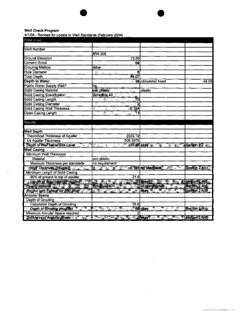
Results
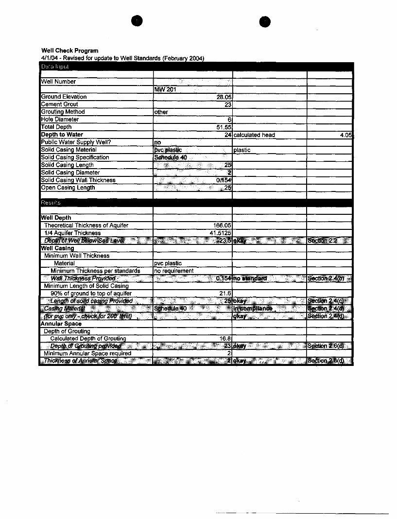
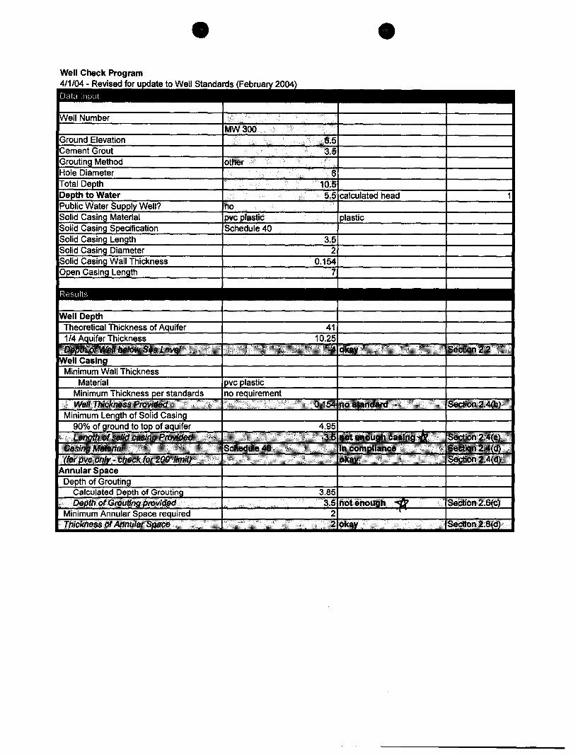
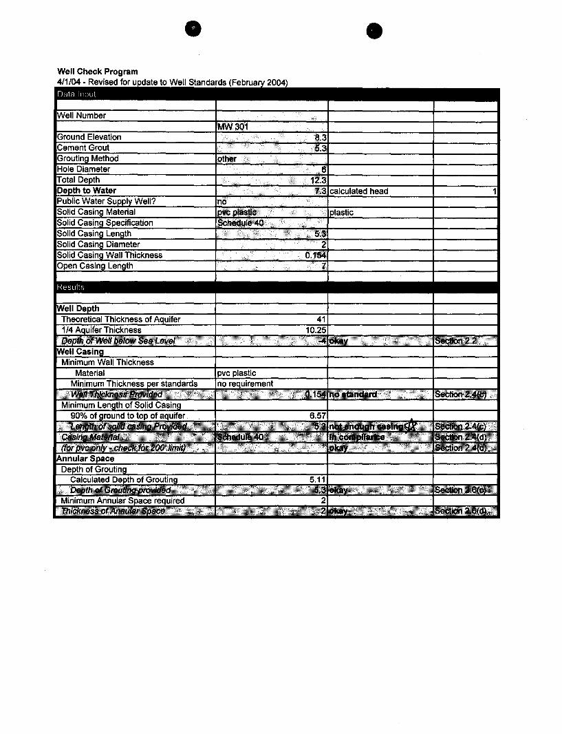
Results
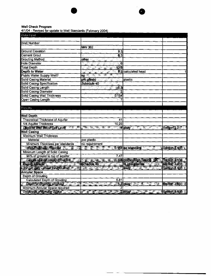
Results
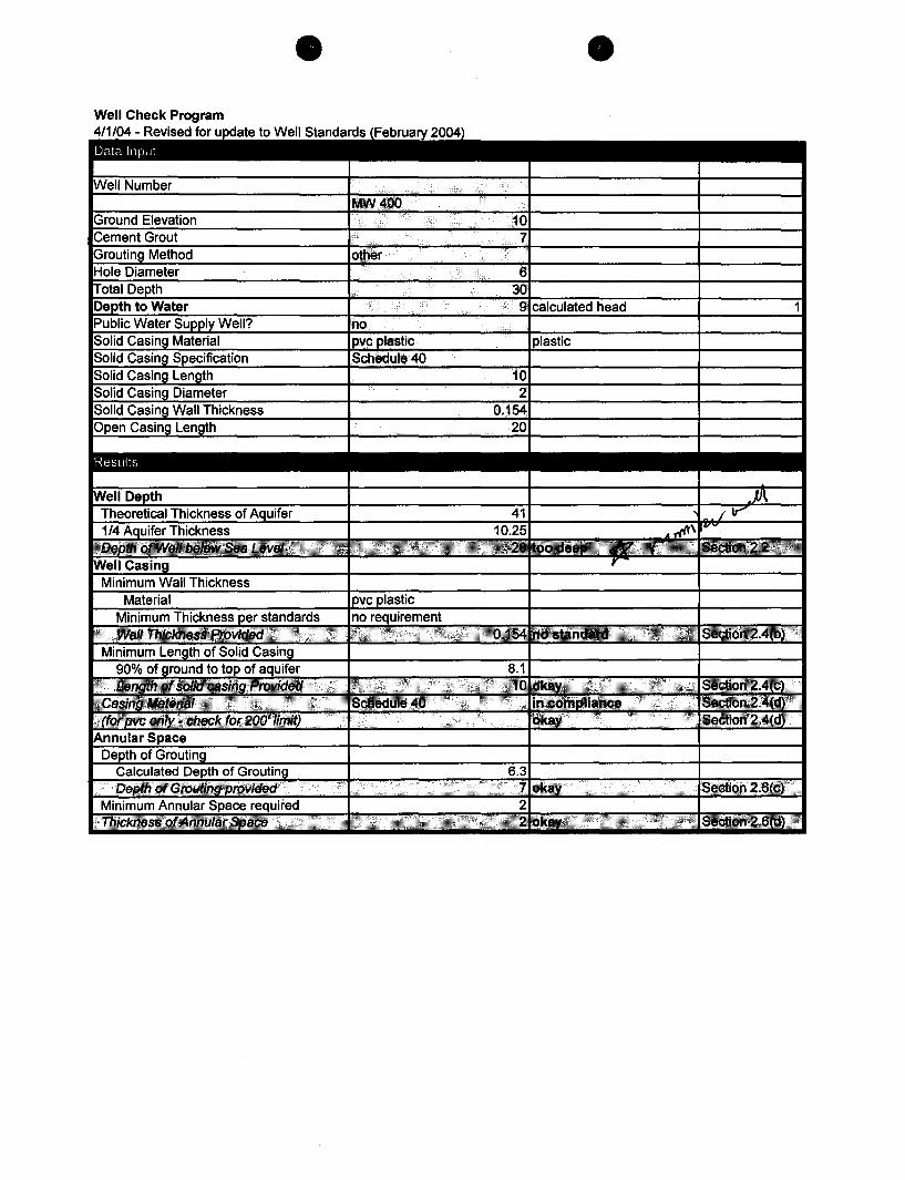
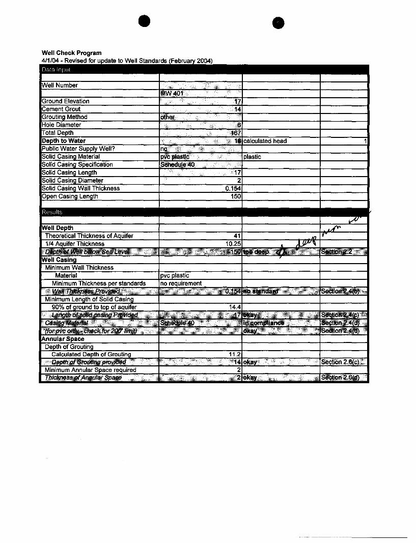
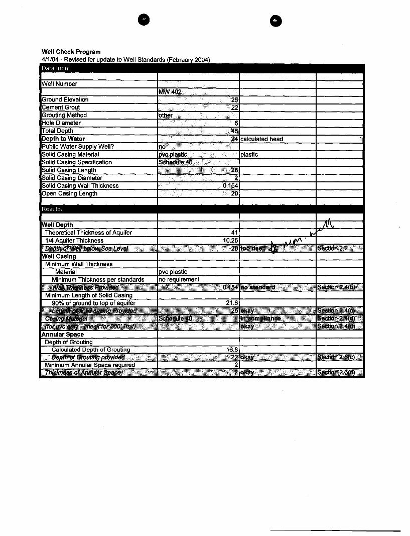
MEMORANDUM FOR THE RECORD
The circumstances surrounding these wells are unique. First of all, the applicant didn't intend for monitor wells 200 & 201 to be long term wells. As a result, these temporary monitor wells don't usually require well construction permits. Because we are requiring the wells to be permanent, and because Geolabs does not normally drill the types of wells that we regulate, it's better not to send the after-the-fact permits to Geolabs because that would give them the mistaken impression that permits are required for temporary wells. Additionally, because the applicant didn't know who drilled wells 300, 301 and 302, we will have to send the A TF permits to the applicant anyway.
Therefore, although Geolabs applied for 200 & 201 as After-the-Fact permit applications, we should issue the permits to Discovery Land LLC.
LINDA LINGLE GOVERNOR OF HAWAII
October 21,2008
STATE OF HAWAII DEPARTMENT OF LAND AND NATURAL RESOURCES
STATE mSTORIC PRESERVATION DMSION 601 KAMOKILA BOULEVARD, ROOM 555
KAPOLEI, HAWAII 96707
LAURA B. 1'IIIELEN CIIAIRPER80N
BOARD OF I...AND AND NAnJRAL RESOURCES COMMISSION ON WATER RESOURCE MANAGEMENT
RUSSELL Y. TSun FIRST DEPlTTY
KEN C. KAWAHARA DEP1JIYDIRECTOR· WAlER
AQUATIC RESOURCES BOATING AND OCEAN RECREATION
BUREAU OF CONVEYANCES COMMISSION ON WATER RESOURCE MANAGEMENT
CONSERVATION ANDCOASTAL LANDS OONSERVA11ON AND RESOURCES ENFORCEMENT
ENGINEERING FORESTRY AND WILDLIFE HISTORIC PRESERVATION
KAHOOLAWE ISLAND ~ERVE COMMISSION u.NI)
STATE PARKS
Ken C. Kawahara, P.E., Deputy Director State Commission on Water Resource Management P.O. Box 621
LOG NO: 2008.4027 DOC NO: 08l0TDlO Archaeology
Honolulu, Hawai'i 96809
Dear Mr. Kawahara:
SUBJECT: Chapter 6E-42 Historic Preservation Review -Well Construction/Pump Installation Permit Application Kohanaiki Monitor Wells 200, 201, 300, 301, 302, 400, 401 & 402 Kohanaiki Ahupua'a, North Hilo District, Island of Hawai'i TMK: (3) 7-3-09: 03
Thank you for the opportunity to comment on the subject permit application, which was received in our office on October 14, 2008. The proposed wells will be located within the Shores of Kohanaiki development area, which has undergone historic preservation review. An SHPD-approved monitoring plan is currently in effect within the project area. This plan provides for the monitoring of any land alteration, including the drilling of wells. We therefore assume that an archaeological monitor will be on hand during access to and drilling of the eight monitoring wells.
We believe that no historic properties will be affected by this proposed activity because: o New construction or land alteration will not occur in connection with the permit o Residential development/urbanization has altered the land o Previous grubbing/grading has altered the land D An accepted archaeological inventory survey (AIS) found no historic properties [gJ SHPD previously reviewed this project and mitigation has been completed [gJ Other: An approved archaeological monitoring plan for this project area provides for the
monitoring of the well installation activities.
Please contact Theresa Donham at (808) 933-7653 if you have any questions or concerns regarding this letter.
Aloha,
~t?~ak-Nancy McMahon, Deputy SHPO/State Archaeologist and Historic Preservation Manager State Historic Preservation Division
LINDA UNGLE ~ClfHAW'"
Mr. Chris Yuen, Director Planning Department County of Hawaii 101 Pauahi Street Hilo. HI 96720
Dear Mr. Yuen:
STATE OF HAWAII DEPARTMENT OF lAND AND NATURAL RESOURceS
COMMISSION ON WATER RESOURCE MANAGEMENT P.O. BOX 821
HONOLULU, HAWAII 98eot
Special Management Area Use Pennit Requirements for WeU Construction Pennit Application
Kohanaikj Monitor WeDs (Well Nos. - Sec attached sheet)
LAURA H. THIELEN ............ MEREDITH J. CHING .lAMESA. FRAZlER NI!AL 8. FUJlWNIA
CHIVOME L. FUIONO, M.D. DONNA FAY K.IOYOSAICI, P E LAWRENCE H. MIlKE, M.D •. J D
KEH C. Ko\WAHARA, P.E IIIIVIYII.OGTDII
Transmitted for your review and comment is a copy of the captioned Well Construction pcnnit application.
We would appreciate your comments on the captioned application with regard to the SMA pennitting requirements specific to your division. Please 8!H0od by returning !is ~gver memo form by Oetober 7.1008. If we do not receive comments or a request fOr tional reVlcw time y this date. we will assume you have no comments.
Please find the attached maps to locate the proposed well. If you have any questions about this permit application. request additional infonnation. or request additional review time. please contact Ryan Ima1a of the Commission staffat 587-0255.
RI
RESPONSE:
Sincerely.
LAURA H. THIELEN Cbairperson
This well project J><i. requires [ ] does not require a SMA. lfa SMA is required it ~ has [ ] has not been approved and ~ is [ ] is not currently active.
[ ]
[ ]
[ ]
Other relevant rulcs/regulations, information, or recommendations are attached.
No objections
Other comments:
Contact Person: j)CUNl.. O~ Signed: ~O~
Phone: %m--'fbl-<Ja~~ y;, :J--n Date: \0 1'1 f~
Theresa K Donham/DLNRlStateHiUS
10/22/2008 06:54 AM
Ryan, Here's the letter.
11 081 OTD 10. pdf
Ryan R Imata/DLNRIStateHiUS
Ryan R ImatalDLNRlStateHiUS
10/21/200802:42 PM
Hey Theresa,
To Ryan R Imata/DLNRIStateHiUS@StateHiUS
ee
bee
Subject Re: Kohanaiki-Ietter~
To Theresa K Donham/DLNRIStateHiUS@StateHiUS
ee
Subject Kohanaiki
Sorry to bother you again. Any status on the Kohanaiki Monitor Well review? I hate to keep asking you about this, but our deputy director is asking.
Thanks,
Ryan
"Oana Okano" <[email protected]>
10107/200808:13 AM
To <Ryan.R.lmata@hawaiLgov>
ee
bee
Subject RE: Kohanaiki Monitor Wells
Hi Ryan,
Construction of these wells is covered under SMA 439 for Kohanaiki so they are approved. See attachment.
Dana
C])ana Ofi.gno Pfanning C])epartment County ofJfawaii 101 PaualiiSt., Ste. 3
J{jlo, J{J 96720
(808) 961-8288 eJ(J;. 271
-----Original Message-----From: [email protected] [mailto:[email protected]] Sent: Monday, October 06,20084:36 PM To: cyuen; Okano, Dana; [email protected] Cc: [email protected] Subject: Kohanaiki Monitor Wells
With my sincerest apologies, I'd like to ask you to review the attached applications and provide your comments to me by Wednesday morning (10/8), if possible. These are the applications I e-mailed each of you about a few weeks ago.
The consultant just informed me last Friday that the driller will be starting the Kohanaiki 8 Well (which we approved awhile back) and wanted to move the rig over to start drilling the monitor wells onThursday.
Sorry, the maps are all over the place in these documents. The applicant sent the applications all messed up.
I'll be out of the office tomorrow on vacation, but I'll be back on Wednesday. If you have any questions tomorrow, you can call my cell phone at 551-7683.
Thanks, I really appreciate your help.
Ryan Imata, P.E. Regulation Branch Commission on Water Resource Management
Ryan R Imata/DLNRlStateHIUS
10/06/2008 04:36 PM
To "cyuen" <[email protected]>, "Okano, Dana" <[email protected]>, Morgan E Davis/DLNRlStateHiUS@StateHiUS
cc Roy Hardy/DLNRIStateHiUS@StateHiUS
bcc
Subject Kohanaiki Monitor Wells
With my sincerest apologies, I'd like to ask you to review the attached applications and provide your comments to me by Wednesday morning (1 0/8} , if possible. These are the applications I e-mailed each of you about a few weeks ago.
The consultant just informed me last Friday that the driller will be starting the Kohanaiki 8 Well (which we approved awhile back) and wanted to move the rig over to start drilling the monitor wells onThursday.
Sorry, the maps are all over the place in these documents. The applicant sent the applications all messed up.
I'll be out of the office tomorrow on vacation, but I'll be back on Wednesday. If you have any questions tomorrow, you can call my cell phone at 551-7683.
Thanks, I really appreciate your help.
Ryan Imata, P.E. Regulation Branch Commission on Water Resource Management Department of Land and Natural Resources State of Hawaii 587-0255 (business) 587-0219 (fax)
Kohanaiki Request for Review Comments.PDF KO MW300s. pdf Kohanaiki Monitor Well 400 series. PDF
Kohanaiki 200 and 300 maps. PO F
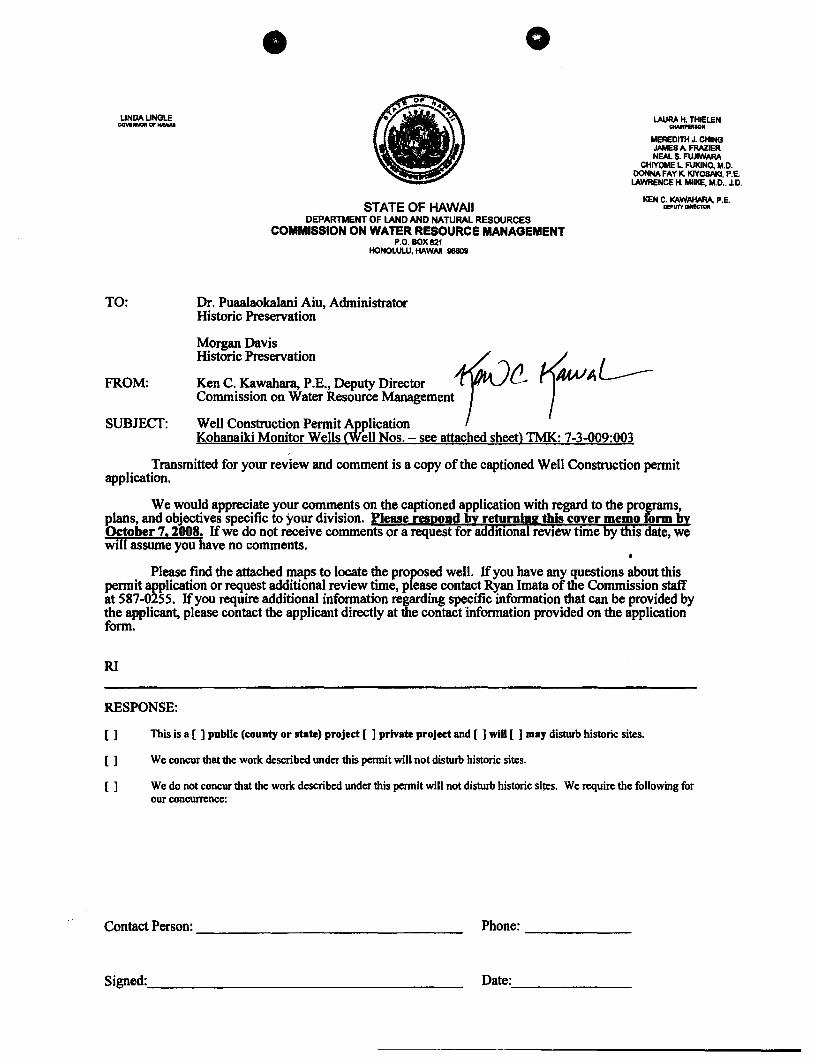
LINDA LINGLE GOVI'IINOR Of' HAWAII
o
LAURA H. THIELEN _ION
MEREDITH J. CHING JAMES A. FRAZIER NEAL S. FUJIWARA
CHIYOME L FUKlNO, M.D. DONNA FAY K. KlYOSAKI, P.E. LAWRENCE H. MIlKE, M.D .. J.D.
TO:
FROM:
SUBJECT:
STATE OF HAWAII DEPARTMENT OF LAND AND NATURAL RESOURCES
COMMISSION ON WATER RESOURCE MANAGEMENT P.O.80X621
HONOLUl.U, HAWAII 96809
Dr. Puaalaokalani Aiu, Administrator Historic Preservation
Morgan Davis Historic Preservation t Ken C. Kawahara, P .E., Deputy Director . t!.-Commission on Water Resource Management
Well Construction Pennit Application Kohanaiki Monitor Wells (Well Nos. - see attached sheet> TMK: 7-3-009:003
KEN C. KAWAHARA, P.E. .,.,.urtDlMCTOll
Transmitted for your review and comment is a copy of the captioned Well Construction permit application.
We would appreciate your comments on the captioned application with regard to the programs, plans, and objectives specific to your division. Please respond by returning this cover memo form by October 7,1008. If we do not receive comments or a request for additional review time by this date, we will assume you have no comments.
Please find the attached maps to locate the proposed well. If you have any questions about this pennit application or request additional review time, please contact Ryan Imata of the Commission staff at 587-0255. If you require additional infonnation regarding specific infonnation that can be provided by the applicant, please contact the applicant directly atthe contact infonnation provided on the application fonn.
RI
RESPONSE:
[ ] This is a [ ] public (county or state) project [ ] private project and [ J will [ ] may disturb historic sites.
[ ] We concur that the work described under this pennit will not disturb historic sites.
[ J We do not concur that the work described under this permit will not disturb historic sites. We require the following for our concurrence:
Contact Person: _______________ _ Phone: _____ _
Signed: ________________ _ Date: _______ _
LINDA LINGLE GOYEftNOIII OF HAWAII
LAURA H. THIELEN _ION
MEREDITH J. CHING JAMES A. FRAZIER NEAL S. FUJMlARA
CHIYOME L. FUKlNO, M.D. DONNA FAY K. KlYOSAKI, P.E. LAWRENCE H. MIlKE, M.D., J.D.
STATE OF HAWAII KEN C. KAVVAHARA, P.E.
TO:
FROM:
SUBJECT:
DEPARTMENT OF lAND AND NATURAL RESOURCES COMMISSION ON WATER RESOURCE MANAGEMENT
P.o. BOX 821 HONOLULU,HAVVAl ~
Dr. Puaalaokalani Aiu, Administrator Historic Preservation
Morgan Davis Historic Preservation to Ken C. Kawahara, P.E., Deputy Director 1 'tLr ~V Commission on Water Resource Management I Well Construction Permit Application Kohanaiki Monitor Wells (Well Nos. - see attached sheet) TMK: 7-3-009:003
DEPUTYDOIIfC1<lII
Transmitted for your review and comment is a copy of the captioned Well Construction permit application.
We would appreciate your comments on the captioned application with regard to the programs, plans, and objectives specific to your division. Please respond by returning this cover memo form by October 7, 1008. If we do not receive comments or a request for additional review time by ibis date, we will assume you have no comments.
Please find the attached maps to locate the proposed well. If you have any questions about this permit application or request additional review time, please contact Ryan Imata of the Commission staff at 587-0255. If you require additional information regarding specific information that can be provided by the applicant, please contact the applicant directly at·the contact information provided on the application form.
R1
RESPONSE:
[ ] This is a [ ] public (county or state) project [ ] private project and [ ] will [ ] may disturb historic sites.
[ 1 We concur that the work described under this pennit will not disturb historic sites.
[ 1 We do not concur that the work described under this pennit will not disturb historic sites. We require the following for our concurrence:
ContactP«son: ________________________________ __ Phone: __ ..&-__ _
Signed: ________________ _ Date: ---------------
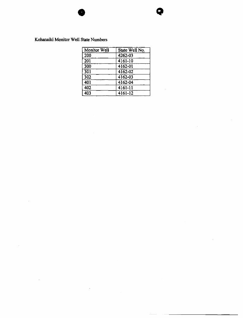
Kohanaiki Monitor Well State Numbers
Monitor Well State Well No. 200 4262-03 201 4161-10 300 4162-01 301 4162-02 302 4162-03 401 4162-04 402 4161-11 403 4161-12
~
__ ,~'"'-_~'~~-=_""""""~."'~~r~.~"',,"""->'~,"=,.~_.,,~.,=,~.u._·.~_~....,""'~~"""-""' __ ,.;"'''''''''"'''"''"""'' ...... __ ... if "",","",*" ~_' .. ,*i .. "ad~"'" .............. ~L ..
yvAIME~ WATER SERVICES, INC.
9-26-08 Koh A 9-26-08 Koh B ~-26-08 Koh C
\
9-26-08 CHECK #
Kohanaiki 400-401-4 Kohanaiki 200-201 Kohanaiki 300-301-3
7954
25.00 25.00 25.00
75.00
25.00 25.00 25.00
75.00
7954
I

-OARTMENT OF LAND AND NATURAL RESO~S
DOCUMENT NO .. UAC OR ATTACHED WORKSHEET DATE S t b 29 2008 eplem er ,
SRC/ COST F YR APP D OBJ CTR PROJECT PH ACT AMOUNT NAME/DESCRIPTION 0NANG INPUT)
S 09 326 C 1026 0752 (1 ) $75.00 Waimea Water Services
" " " " " " (2) $25.00 Derrick's Well Drilling and Pump Services, LLC
(3)
(4)
(5)
(6)
(7)
(8)
(9)
(10)
TOTAL $ 75.00
REMARKS: LINE (1) Kohanaiki Wells 400, 401, 402, 200, 201, 300 301 & 302 LINE (2) YY Investment LLC Well #2 LINE (3 LINE (4) LINE (5) LINE (6) LINE (7) LINE (8) LINE (9) LINE (10)
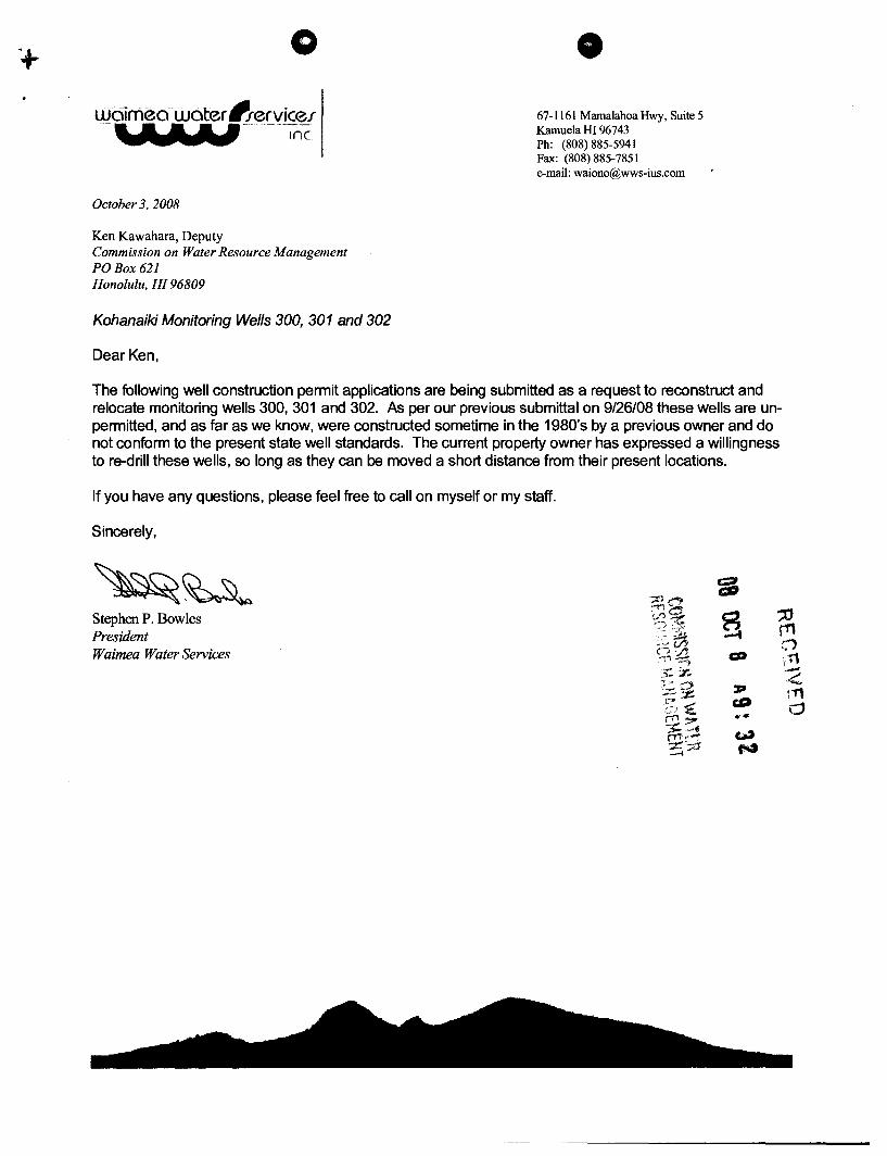
o liJaimea . water 'fervicef -a ...... M-- .-.~
UWWlLY Inc.
October 3, 2008
Ken Kawahara, Deputy Commission on Water Resource Management POBox 621 Honolulu, HI 96809
Kohanaiki Monitoring Wells 300, 301 and 302
Dear Ken,
67-1161 MamalahoaHwy, Suite 5 Kamuela HI 96743 Ph: (808) 885-5941 Fax: (808) 885-7851 e-mail: [email protected]
The following well construction permit applications are being submitted as a request to reconstruct and relocate monitoring wells 300, 301 and 302. As per our previous submittal on 9/26/08 these wells are unpermitted, and as far as we know, were constructed sometime in the 1980's by a previous owner and do not conform to the present state well standards. The current property owner has expressed a willingness to re-drill these wells, so long as they can be moved a short distance from their present locations.
If you have any questions, please feel free to call on myself or my staff.
Sincerely,
Stephen P. Bowles President Waimea Water Services

STATE OF&AII DEPARTMENT OF LAND AND NATURAL RESOURCES COMMISSION ON WATER RESOURCE MANAGEMENT APPLICATION FOR A WELL CONSTRUCTION I PUMP INSTALLATION PERMIT
Instructions: Please print in ink or type and send completed application with attachments to the Commission on Water Resource Management. P.O. Box 621. Honolulu. Hawaii 96809. Application must be accompanied by 10 copies and a non-refundable filing fee of $25.00 payable to the Dept. of Land and Natural Resources. The Commission may not accept incomplete applications. For assistance. call the Regulation Branch at 587-0225. For further information and updates to this application form. visit http://www.hawaii.gov/dlnr/cwrm.
To be determined Ucensee business name C-S7 Ucense No.
Signature Print Date
Address
12. Proposed Amount of Withdrawal. gpd (gallons per day)
all Well Permits
Ucensee business name
Signature Print
Address
D
UB OCT 8 32
C-S7/C-57a/A Ucense No.
Date
WCPI Application Form OS/12/200S
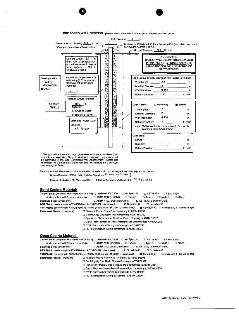
PROPOSED WELL SECTION (Please attach schematic if different from diagram provided below)
Hole Diameter: __ 6 __ in.
Elevation at top of casing ~ ft .• msl' \ L [ 1..-:-;- Minimum of 2' Radius & 4" Thick Concrete Pad (to contain benchmark
• Casing to be vaulted at land sUrface ... : ~, .. :;.:, ••.. '. surveyed to nearest 0.01 ft.)
Grouting method:
D Positive displacement
• Other
Total Depth
~ft.
r,j~); ~~ r Ground Elevation: ~ft., msl'
.-_________ -,'1""" '.";.:; :~:.{: """" """" Please refer to the Cement Groul: 3.5 ft. ;.,'. (min. 70% of distance from ::;'. '.,. HAWAII WELL CONSTRUCTION ANP ground elevation to top of :.:.; ;,. •. ' PUMP INSTALLATION STANDARDS water surface or 500 ft., ::(. ~:t. to ensure that your as-built is in compliance with
whiChever is less.) Jr {i applicable standards.
Annular space between hole and casing (1.5" for positive displacement, 3" for other methods):
__ 2_ in.
Rock or Gravel Packing:
N/A ft. Material:
D Crushed Basalt
D Rounded Gravel
'-;::::=====~-u;: "~~f-Estimated Water Level
Elevation:
__ +_1_ft. msl' ~--
--~
Solid Casing: (,. 90% x (Ground Elev.-Water Level Elev))
Total Length: 3.5 ft.
Nominal Diameter: 2 in.
Wall Thickness: ___ 0_._15_4 _______ in.
Bottom Elevation: +3 ft., msl'
Open Casing: D Perforated • Screen
Total Length: ___ --'-7 ________ ft.
Nominal Diameter: _---'2=--_______ in.
Wall Thickness: __ -"0;;. . .:-15=-4-'-_____ in.
Bottom Elevation: ___ --'4 ______ ft., msl'
note: Neither bentonite nor mud should be used in saturated zone during drilling
Open Hole:
Length: _____________ ft.
Diameter: _____________ in.
Bottom Elevation: _________ ft., msl'
• The approximate elevation must be referenced to mean sea level (msl) at the time of application filing. Final elevations of well components shall be submitted in the Well CompletionlWell Abandonment reports and referenced to a benchmark which has been established by a surveyor licensed by the State.
For non-5alt water Basal Wells - bottom elevation of well should not be deeper than 1/4 of aquifer thickness or,
Bottom Elevation of Well Limit = (water Elevation _ 41 x Wattt L~el Elevation )
Example: Estimated +211. Water Level Elev. _Bottom Elevation of Well Limit = (2- ~) = -18.5ft.
Solid Casing Material: Carbon Steel: compliant with (check one or more): D ANSI/AWWA C200 D API Spec. 5L D ASTMA53 D ASTMA139
And compliant with (check one or more): D ASTM A242 (or A606) D Type E D Type S D Grade B D Other
Stainless Steel: (check one): D ASTM M09 (production wells) D ASTM A312 (monitor wells) ABS Plastic conforming to ASTM F480 and ASTM D1527: (check one) D Schedule 40 D Schedule 80
PVC Plastic conforming to ASTM F480 and (ASTM D1785 or ASTM D2241 ): (check one): • Schedule 40 D Schedule 80 D Schedule 120
Thermoset Plastic: (check one)
Open Casing Material:
D Filament Wound Resin Pipe conforming to ASTM D2996 D Centrifugally Cast Resin Pipe conforming to ASTM D2997
D Reinforced Plastic Mortar Pressure Pipe conforming to ASTM D3517 D Glass Fiber Reinforced Resin Pressure Pipe conforming to AWWA C950
D PTFE RuorocarIJon Tubing conforming to ASTM D3296 D FEP Fluorocarbon Tubing conforming to ASTM D3296
Carbon Steel: compliant with (check one or more): D ANSI/AWWA C200 D API Spec. 5L D ASTM A53 D ASTM A139
And compliant with (check one or more): D ASTM A242 (or A606) D Type E D Type S D Grade B D Other
Stainless Steel: (check one): D ASTM M09 (production wells) D ASTM A312 (monitor wells)
ABS Plastic conforming to ASTM F480 and ASTM 01527: (check one) D Schedule 40 D Schedule 80
PVC Plastic conforming to ASTM F480 and (ASTM 01785 or ASTM D2241): (check one): • Schedule 40 D Schedule 80 D Schedule 120
Thermoset Plastic: (check one) D Filament Wound Resin Pipe conforming to ASTM D2996
D Centrifugally Cast Resin Pipe conforming to ASTM D2997
D Reinforced Plastic Mortar Pressure Pipe conforming to ASTM D3517
D Glass Fiber Reinforced Resin Pressure Pipe conforming to AWWA C950
D PTFE RuorocarIJon Tubing conforming to ASTM 03296
D FEP Fluorocarbon Tubing conforming to ASTM 03296
WCPI Application Form 05/12/2005

PROPOSED WELL SECTION (Please attach schematic if different from diagram provided below)
Hole Diameter: __ 6 __ in.
Elevation at top of casing ~ ft .. mSI""""\ I [ Minimum of 2' Radius & 4" Thick Conaete Pad (to contain benchmark
"Casing to be vaulted at land surface ~ ~ ~ surv~ed ~r:~~~~:e~~t;o~;) ~ft., msl"
,----------,""""" :}: ::;.~:. "'-" ,,-" Please refer to the Cement Grout: 5.3 ft. ;.; (min, 70% of distance from :. ,. '. ,. HAWAII WELL CONSTRUCTION AND ground elevation to top of .' '-'.~ PUMP INSTALLATION STANDARDS water surface or 500 ft., ~): {t. to ensure that your as-built is in compliance with whichever is less.) i;; ~:P applicable standards.
Grouting method: Annular space between hole and casing (1.5" for positive displacement, 3" for other methods):
::~. ;.~.
,':' !.:.: ~ Solid Casing: (;. 90% x (Ground Elev.-Water Level Elev))
o Positive displacement ¥ J Total Length: 5.3 ft.
V ;-~~ ~~:.~ Nominal Diameter: 2 in.
• Other __ 2_ in.
<-;=R=o=ck=or=G=r=a=v=el=p=a=ck=i=n=g=: =~--+- ~ W Wall Thickness: __ -'0"-,.:..15=-4=--______ in.
Bottom Elevation: ___ +_3=-_____ ft., msl"
.------'-N/A ft. Open Casing: o Perforated • Screen
Material:
o Crushed Basalt Total Length: 7 ft.
o Rounded Gravel '-;======;""I-¥-iir ulolI--IlK!il-- Y Nominal Diameter: 2 in.
Wall Thickness: 0.154 in. Estimated Water Level
Elevation: Bottom Elevation: -4 ft., msl"
__ +_1_ft. msl" note: Neither bentonite nor mud should be used in
saturated zone during drilling
Open Hole:
Length: _____________ ft.
Diameter: _____________ in.
--- Bottom Elevation: _________ ft., msl"
"The approximate elevation must be referenced to mean sea level (msl) at the time of application filing. Final elevations of well components shall be submitted in the Well CompletionlWell Abandonment reports and referenced to a benchmark which has been established by a surveyor licensed by the State.
For non-5alt water Basal Wells - bottom elevation of well should not be deeper than 1/4 of aquifer thickness or,
Bottom Elevation of Well Limit = (Water Elevation _ 41 x Wat<r ~el Eleyation )
Example: Estimated + 2 ft, Water Level Elev. _ Bottom Elevation of WeI Limit = (2. ¥) = -18,5 ft,
Solid Casing Material: Carbon Steel: compliant with (check one or more): 0 ANSI/AWWA C200 0 API Spec. 5L 0 ASTM A53 0 ASTM A139
And compliant with (check one or more): 0 ASTM A242 (or A606) 0 Type E 0 Type S 0 Grade B 0 Other
Stainless Steel: (check one): 0 ASTM A409 (production wells) 0 ASTM A312 (monitor wells)
ABS Plastic conforming to ASTM F480 and ASTM D1527: (check one) 0 Schedule 40 0 Schedule 80
PVC Plastic conforming to ASTM F480 and (ASTM D1785 or ASTM D2241 ): (check one): • Schedule 40 0 Schedule 80 0 Schedule 120
Thermoset Plastic: (check one) o Filament Wound Resin Pipe conforming to ASTM 02996
o Centrifugally Cast Resin Pipe conforming to ASTM D2997
o Reinforced Plastic Morlar Pressure Pipe conforming to ASTM 03517
o Glass Fiber Reinforced Resin Pressure Pipe conforming to AWWA C950
o PTFE Ruorocarnon Tubing conforming to ASTM D3296
o FEP Fluorocarbon Tubing conforming to ASTM D3296
Open Casing Material: Carbon Steel: compliant with (check one or more): 0 ANSI/AWWA C200 0 API Spec. 5L 0 ASTM A53 0 ASTM A 139
And compliant with (check one or more): 0 ASTM A242 (or A606) 0 Type E 0 Type S 0 Grade B 0 Other
Stainless Steel: (check one): 0 ASTM M09 (production wells) 0 ASTM A312 (monitor wells)
ABS Plastic conforming to ASTM F480 and ASTM D1527: (check one) 0 Schedule 40 0 Schedule 80
PVC Plastic conforming to ASTM F480 and (ASTM 01785 or ASTM D2241 ): (check one): • Schedule 40 0 Schedule 80 0 Schedule 120
Thermoset Plastic: (check one) o Filament Wound Resin Pipe conforming to ASTM D2996
o Centrifugally Cast Resin Pipe conforming to ASTM D2997
o Reinforced Plastic Mortar Pressure Pipe conforming to ASTM D3517
o Glass Fiber Reinforced Resin Pressure Pipe conforming to AWWA C950
o PTFE Ruorocarnon Tubing conforming to ASTM D3296
o FEP Fluorocarbon Tubing conforming to ASTM 03296
WCPI Application Form 05/12/2005
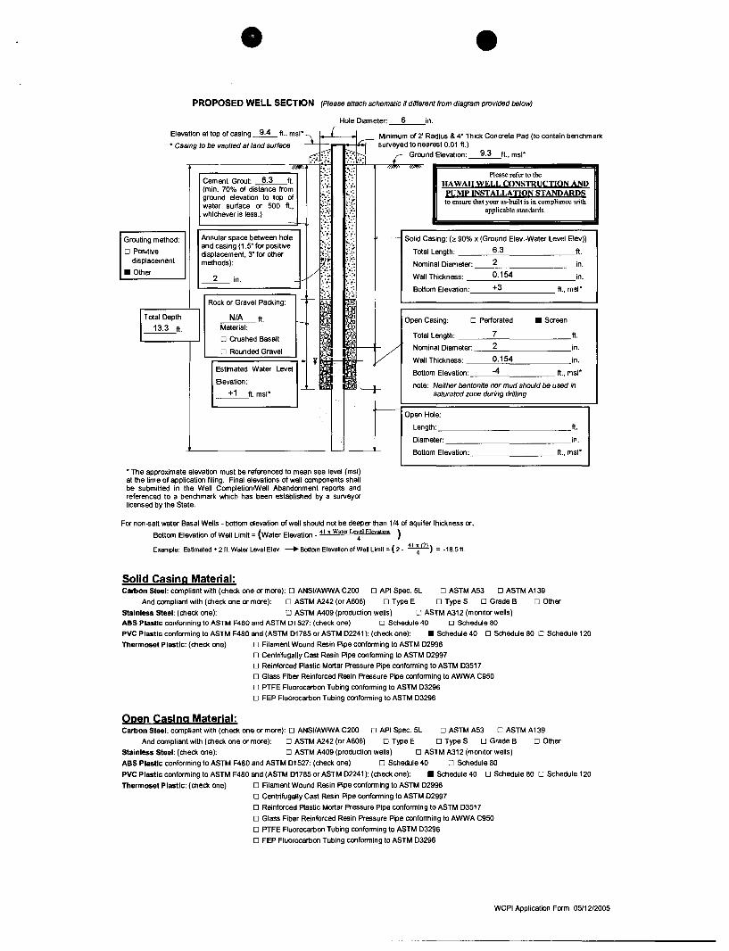
PROPOSED WELL SECTION (Please attach schematic if different from diagram provided below)
Hole Diameter: __ 6 __ in.
Elevation at top of casing ~ ft., msl" 't L { J Minimum of 2' Radius & 4" Thick Concrete Pad (to contain benchmark
" CasIng to be vaulted at land surface dp ~ surv~d ~r:~~e::e~~t;o~'? ~ft., msl"
....-_______ ...,/1""'" :.".:: .".:: '''~" '"'''''' ".4. ..~.: Please refer to the
Cement Grout: 6.3 ft. (min. 70% of distance from ground elevation to top of water surface or 500 ft., whichever is less.)
~.:;'. :. ~. !-:.: ~:.:
~:!: .:.~.,(.:. ~:~:.
HAWAII WELL CONSTRUCIION AND PUMP INSTALLATION STANDARDS to ensure that your as-built is in compliance with
applicable standards.
t~~: .~~: Grouting method: Annular space between hole
and casing (1.5" for positive displacement, 3" for other methods):
'::~: :.~. ..... !.:.: >-------- Solid Casing: (~90% x (Ground Elev.-Water Level Elev))
o Positive ~ ;.:r-Total Length: 6.3 ft.
.... '~:',
displacement Nominal Diameter: __ 2 ________ in.
v<~ ;'.: . :. ~. :. ~.
• Other 2 in.
Wall Thickness: ___ 0_._15_4 _______ in.
~======~ .. :: ":' r- -cr- :,i; :,. Bottom Elevation: ___ +_3 _____ ft., msl"
Rock or Gravel Packing:
N/A ft. Material:
o Crushed Basalt
o Rounded Gravel
'r======;"'i-u. v~~1- Y
Open Casing: o Perforated • Screen
T ctal Length: 7 ft.
Nominal Diameter: 2 in.
Wall Thickness: 0.154 in. Estimated Water Level
Elevation: Bottom Elevation: -4 ft., msl"
__ +_l_ft. msl" -c.- note: Neither bentonite nor mud should be used in
saturated zone during drilling
Open Hole:
Length: _____________ ft.
Diameter: _____________ in. _ ----'- Bottom Elevation: ft., msl"
"The approximate elevation must be referenced to mean sea level (msl) at the time of application filing. Final elevations of well components shall be submitted in the Well CompletionlWell Abandonment reports and referenced to a benchmark which has been established by a surveyor licensed by the State.
For non-salt water Basal Wells - bottom elevation of well should not be deeper than 1/4 of aquifer thickness or,
Bottom Elevation of Well Limit = (water Elevation _ 41 x Wata L"'4el Eleyation )
Example: Estimated + 2 ft. Water Level Elev. -+ Bottom Elevation of Well Limit = (2 _ 41 ~ (2») = -IB.5ft.
Solid Casing Material: Carbon Steet: compliant with (check one or more): 0 ANSI/AWWA C200 0 API Spec. 5L 0 ASTM A53 0 ASTM A139
And compliant with (check one or more): 0 ASTM A242 (or A606) 0 Type E 0 Type S 0 Grade B 0 Other
Stainless Steel: (check one): 0 ASTM A409 (produdion wells) 0 ASTM A312 (monitor wells}
ABS PlastiC conforming to ASTM F480 and ASTM D1527: (check one) 0 Schedule 40 0 Schedule 80
PVC Plastic conforming to ASTM F480 and (ASTM D1785 or ASTM D2241): (check one): • Schedule 40 0 Schedule 80 0 Schedule 120
Thermoset Plastic: (check one) o Filament Wound Resin Pipe confonming to ASTM D2996
o Centrifugally Cast Resin PIpe confonming to ASTM D2997
o Reinforced Plastic Mortar Pressure Pipe conforming to ASTM D3517
o Glass Fiber Reinforced Resin Pressure Pipe confonming to AWWA C950
o PTFE Ruorocarbon Tubing confonming to ASTM D3296
o FEP Fluorocarbon Tubing conforming to ASTM D3296
Open Casing Material: Carbon Steel: compliant with (check one or more): 0 ANSIIAWWA C200 0 API Spec. 5L 0 ASTM A53 0 ASTM A 139
And compliant with (check one or more): 0 ASTM A242 (or A606) 0 Type E 0 Type S 0 Grade B 0 Other
Stainless Steel: (check one): 0 ASTM A409 (produdion wells) 0 ASTM A312 (monitor wells)
ABS Plastic conforming to ASTM F480 and ASTM D1527: (check one) 0 Schedule 40 0 Schedule 80
PVC Plastic conforming to ASTM F480 and (ASTM D1785 or ASTM D2241): (check one): • Schedule 40 0 Schedule 80 0 Schedule 120
Thermoset Plastic: (check one) o Filament Wound Resin Pipe confonming to ASTM D2996
o Centrifugally Cast Resin PIpe confonming to ASTM D2997
o Reinforced Plastic Mortar Pressure Pipe conforming to ASTM D3517
o Glass Fiber Reinforced Resin Pressure Pipe confonming to AWWA C950
o PTFE Fluorocarbon Tubing confonming to ASTM D3296
o FEP Fluorocarbon Tubing conforming to ASTM D3296
WCPI Application Form 05/12/2005
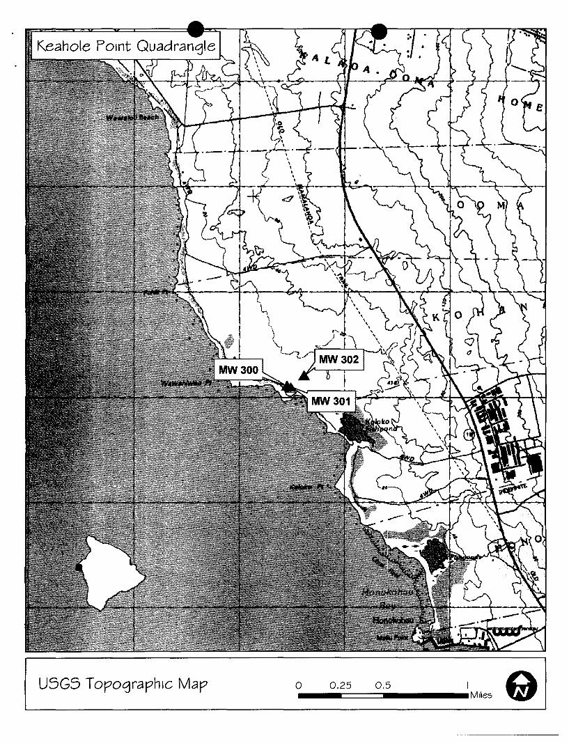
USGS Topographic Map 0 __ 0.:,2=5 ===0.,5 ____ 1 M,les Q I
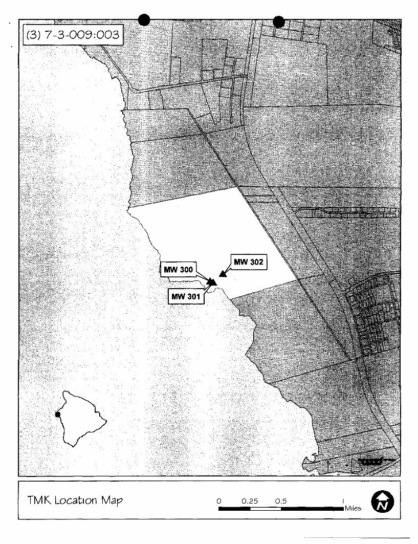
(3) 7-3-009:003
0.25 0.5 I e I -====::::J __ Mlles TMK Location Map o
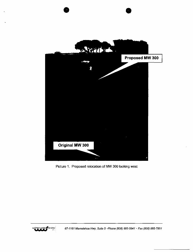
Picture 1. Proposed relocation of MW 300 looking west
67-1161 Mamalahoa Hwy, Suite 5 ·Phone (808) 885-5941 • Fax (808) 885-7851
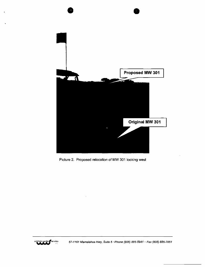
Proposed MW 301
Picture 2. Proposed relocation of MW 301 looking west
67-1161 Mamalahoa Hwy, Suite 5 'Phone (808) 885-5941 • Fax (808) 885-7851
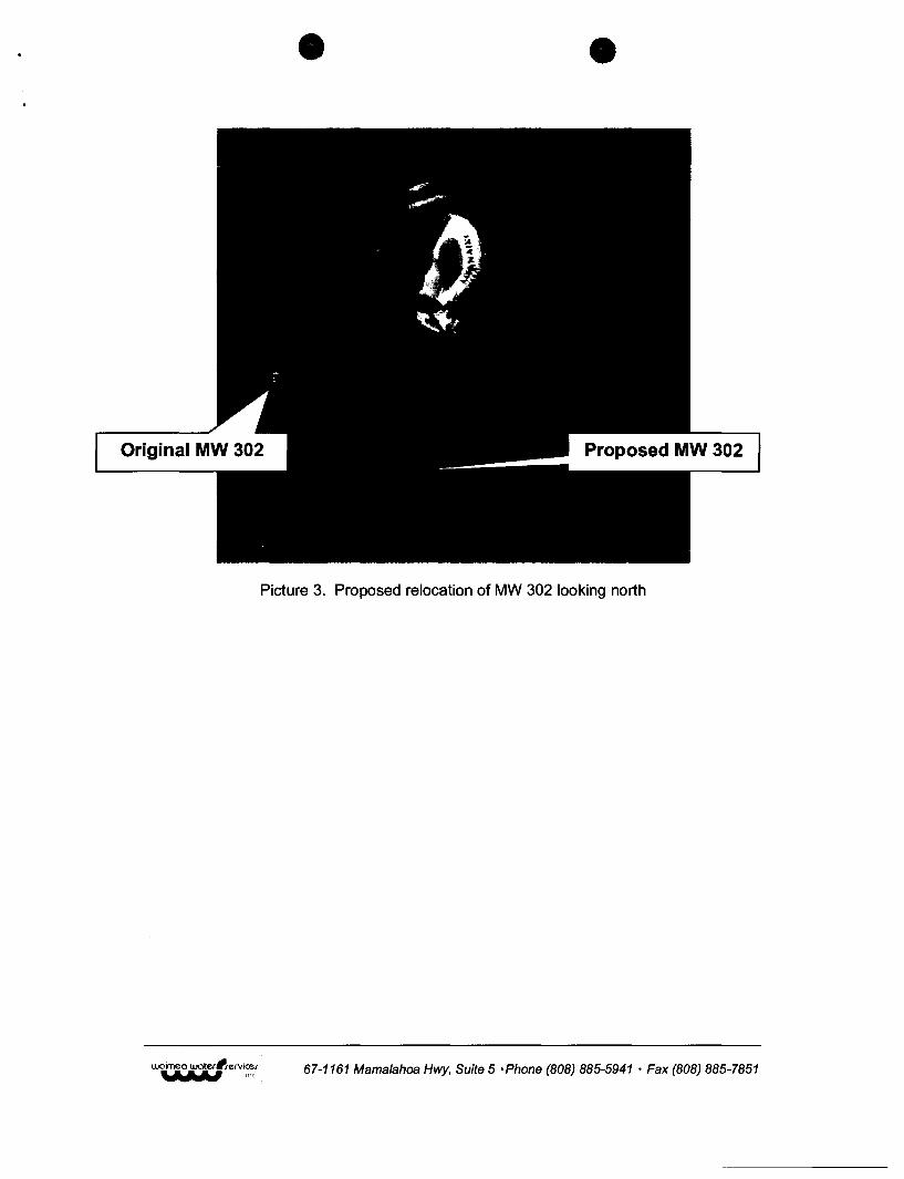
Picture 3. Proposed relocation of MW 302 looking north
67-1161 Mamalahoa Hwy, Suite 5 • Phone (808) 885-5941 • Fax (808) 885-7851
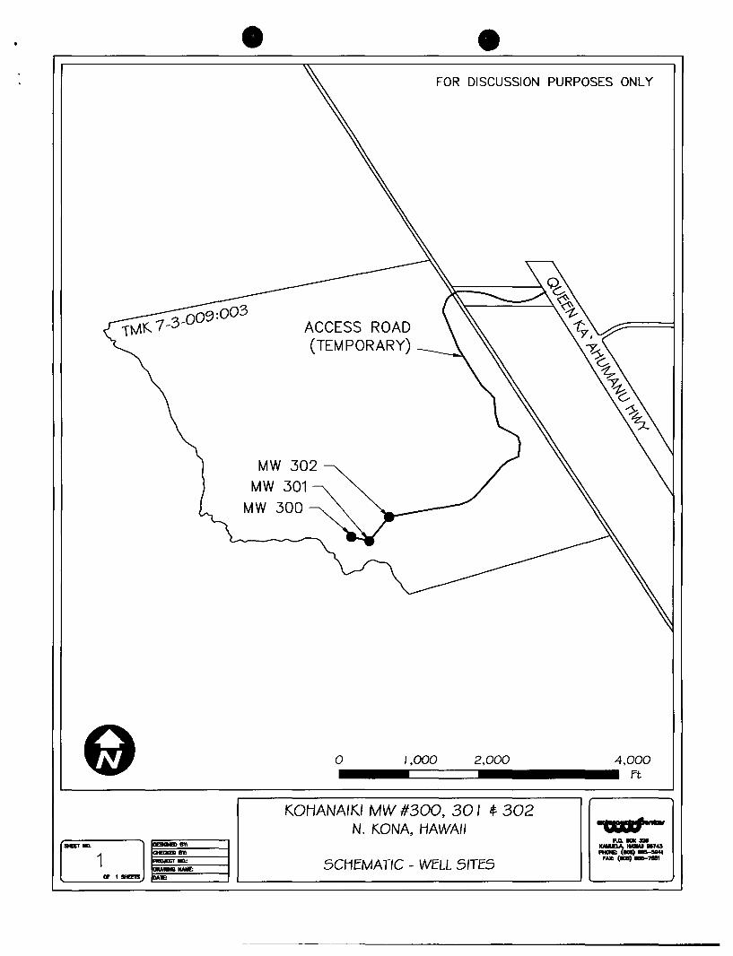
FOR DISCUSSION PURPOSES ONLY
ACCESS ROAD (TEMPORARY)
MW 302
MW 301
o 1.000 2.000 4.000 ...... -=====~............. ~ KOHANAIKI MW #300, 30 I if 302
N. KONA, HAWAII 1",,.-
C2:J P.o. __
MEET .... K-.a.<,. HAWAII _43 - (I0Il) ___ I
1 SCHEMA TIC _ WELL SITES fAX: (IDI) __ 71111
Of ,SItEE1S ~=----I L-___________ ------l '---_--..J
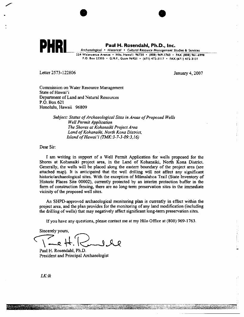
PHRL Paul H. Rosendahl, Ph.D., Inc. Archaeological • Historical • Cultural Resource Management Studies & Services
224 Walanuenue Avenue • Hllo. Hawai'i "720 • (808) "9-176) • FAX (808) 961-6998 P.O. Box 23305 • G.M.F .• Guam 96'21 • (671)'472-3117' FAX (671) 472·3131
Letter 2573-122806
Commission on Water Resource Management State of Hawai' i Department of Land and Natural Resources P.O. Box 621 Honolulu, Hawaii 96809
January 4, 2007
Subject: Status of Archaeological Sites in Areas of Proposed Wells Well Permit Application
Dear Sir:
The Shores at Kohanaiki Project Area Land of Kohanaiki, North Kona District,
Island ofHawai'i (TMK:3-7-3-09:3.16)
I am writing in support of a Well Permit Application for wells proposed for the Shores at Kohanaiki project area, in the Land of Kohanaiki, North Kona District. Generally, the wells will be placed along the eastern boundary of the project area (see attached map). It is anticipated that the well drilling will not affect any significant historic/archaeological sites. With the exception of Mamalahoa Trail (State Inventory of Historic Places Site 00002), currently protected by an interim protection buffer in the form of construction fencing, there are no long-term preservation sites in the immediate vicinity of the proposed well sites.
An SHPD-approved archaeological monitoring plan is currently in effect within the project area, and the plan provides for the monitoring of any land modification (including the drilling of wells) that may negatively affect significant long-term preservation sites.
If you have any questions, please contact me at my Hilo Office at (808) 969-1763.
Sincerely yours,
~~~.~~ Paul H. Rosendahl, Ph.D. President and Principal Archaeologist
LK:lk
waimea ·water'rervicer -- ... ---.- --. -..LlLYLnav I(lC.
September 26, 2008
Ken Kawahara, Deputy Commission on Water Resource Management POBox 621 Honolulu, HI 96809
Kohanaiki Monitoring Well Permitting
Dear Ken,
• 67-1161 Mamalahoa Hwy, Suite 5 Kamuela HI 96743 Ph: (808) 885-5941 Fax: (808) 885-7851 e-mail: [email protected]
Please find the attached documents for permitting of Kohanaiki monitoring wells 400, 401 and 402, as required in the CWRM transmittal dated September 19, 2008. Additionally, well construction applications are submitted for the existing, but unpermitted monitoring wells 200, 201, 300, 301 and 302.
If you have any questions, please feel free to call on myself or my staff.
Sincerely,
Stephen P. Bowles President Waimea Water Services
~~(l " -~ ,-
'3~
i~ ~ .,-',
~ "::~iI'''' ....-'- "") - ~-~ ::::. ~ .::, "E.
;'1 ': .....
~ -<! I .~
-~. - , /'
---1
t:::) co
~ ::r.J -0 i"n
r-:» :, c.a ,on --.,; -).:S q .....a
J . . -(£)
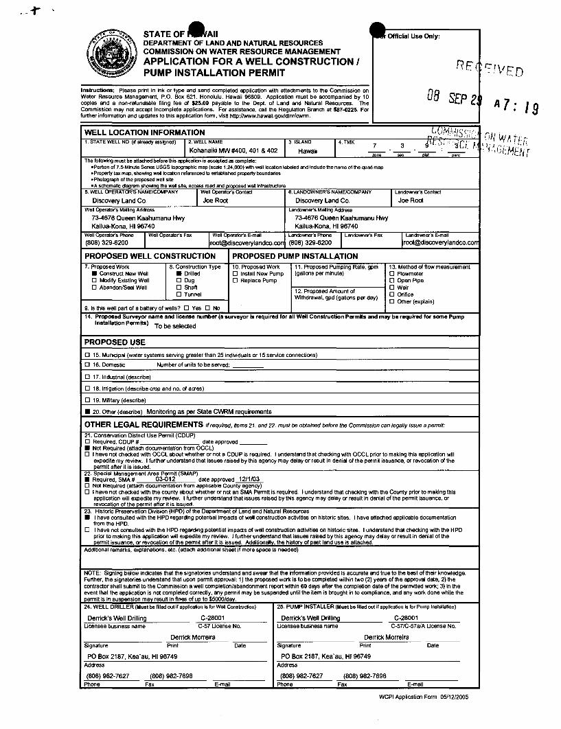
• STATEOF.AII Officfal Use Only: DEPARTMENT OF LAND AND NATURAL RESOURCES ~ COMMISSION ON WATER RESOURCE MANAGEMENT APPLICATION FOR A WELL CONSTRUCTION I RE( PUMP INSTALLATION PERMIT
Instructions: Please print in ink or type and send completed application with attachments to the Commission on D8 Water Resource Management, P.O. Box 621, Honolulu, Hawaii 96809. Application must be accompanied by 10 SEP Z~ copies and a non-refundable filing fee of $25,00 payable to the Dept. of land and Natural Resources. The Commission may not accept incomplete applications. For assistance, call the Regulation Branch at 587-0225. For further information and updates to this application form, viSit http://www.hawaii.gov/dlnr/cwrm.
A 7' 19 WELL LOCATION INFORMATION LU,I.AJ."llsc'h
'" .~ I, J , Ii;., ' 1. STATE WELL NO. (if already assigned) 12. WELL NAME 3. ISLAND 14. TMK 7 3 4\r'~l!',~Ct /' I~
Kohanaiki MW#400, 401 & 402 Hawaii -- --",ne sec "iii8t DaIC The following must be attached before this appication is accepted as oomplete,
oPortion of 7.5-Minute Series USGS topographic map (scale 1'24,000) with well location labeled and include the name of the quad map • Property tax map, showing well location referenced to established property boundaries • Photograph of the proposed well site oA schematic diagram showing the well s~e, access road and proposed well infrastructure
5. WELL OPERATOR'S NAME/COMPANY 1 Well Operato(s Contact 6. LANDOWNER'S NAME/COMPANY I Landowner's Contact
Discovery Land Co. Joe Root Discovery Land Co. Joe Root
Well Operato(s Mailing Address Landowner's Mailing Address
73-4676 Queen Kaahumanu Hwy 73-4676 Queen Kaahumanu Hwy Kailua-Kana, HI 96740 Kailua-Kana, HI 96740
Well Operato(s Phone I Well Operato(s Fax If Well Operator's E-mail landowner's Phone I Landowne(s Fax II Landowner's E-mail (808) 329-6200 [email protected] (808) 329-6200 [email protected]
PROPOSED WELL CONSTRUCTION PROPOSED PUMP INSTALLATION 7. Proposed Work 8. Construction Type 10. Proposed Work 11. Proposed Pumping Rate, gpm 13. Method of flow measurement
• Construct New Well • Drilled o Install New Pump (gallons per minute) o Aowmeter o MOdify Existing Well o Dug o Replace Pump o Open Pipe o Abandon/Seal Well o Shaft
12. Proposed Amount of o Weir
o Tunnel o Orifice Withdrawal, gpd (gallons per day) o Other (explain)
9. Is this wetl part of a battery of wells? 0 Yes DNa
14. Proposed Surveyor name and license number (a surveyor Is required for all Well Construction Permits and may be required for some Pump Installation Permits)
To be selected
PROPOSED USE
o 15. Municipal (water systems serving greater than 25 individuals or 15 service connections)
o 16. Domestic Number of units to be served:
o 17. Industrial (describe)
o 18. Irrigation (describe crop and no. of acres)
o 19. Military (desCribe)
• 20. Other (describe) Monnoring as per State CWRM requirements
OTHER LEGAL REQUIREMENTS If required, Hems 21. and 22. must be obtained before the Commission can legally issue a permit:
21. Conservation District Use Permit (COUP) o Required, CDUP # date approved ____ • Not Required (attach documentation from OCCl) o I have not checked with OCCl about whether or not a CDUP is required. I understand that checking with OCCl prior to making this application will
expedite my review. I further understand that issues raised by this agency may delay or result in denial of the permit issuance, or revocation of the permit after it is issued.
22. Special Management Area Permit (SMAP) • Required,SMA# 03-012 date approved 12/1/03 o Not Required (attach documentation from applicable County agency) o I have not checked with the county about whether or not an SMA Permit is required. I understand that checking with the County prior to making this
application will expedite my review. I further understand that issues raised by this agency may detay or result in denial of the permit issuance, or revocation of the permit after it is issued.
23. Historic Preservation Division (HPO) of the Department of land and Natural Resources
• I have consulted with the HPD regarding potential impacts of wetl construction activities on historiC Sites. I have attached applicable documentation from the HPD.
0 I have not consulted with the HPD regarding potential impacts of wetl construction activities on historic sites. I understand that checking with the HPO prior to making this application will expedrte my review. I further understand that iSSUes raised by this agency may delay or result in denial olthe permit issuance, or revocation of the permrt after it is issued. Additionally, the history of past land use is attached.
Additional remarks, explanations, etc. (attach additional sheet if more space is needed)
NOTE: Signing betow indicates that the signatories understand and swear that the information provided is accurate and true to the best of their knowledge. Further, the signatories understand that upon permit approval: 1) the proposed work is to be completed within two (2) years of the approval date; 2) the contractor shall submit to the Commission a well completion/abandonment report within 60 days after the completion date of the permitted work; 3) in the event that the application is not completed correctly. any permit may be suspended until the item is brought in to compliance, and any work done while the permit is in suspension may result in fines of up to $5000/day.
24. WEll DRillER (Must be filled out if application Is for Well Construction) 25. PUMP INSTAllER (Must be filled out if application Is for Pump Installation)
Derrick's Well Drilling C-28001 Derrick's Well Drilling C-28001 Ucensee business name C-57 Ucense No. Ucensee business name C-57/C-57a/A Ucense No.
Derrick Morreira Derrick Morreira Signature Print Date Signature Print Date
PO Box 2187, Kea'au, HI 96749 PO Box 2187, Kea'au, HI 96749 Address Address
(808) 982-7627 (808) 982-7698 (808) 982-7627 (808) 982-7698 Phone Fax E-mail Phone Fax E-mail
WCPI Application Form 05/12/2005
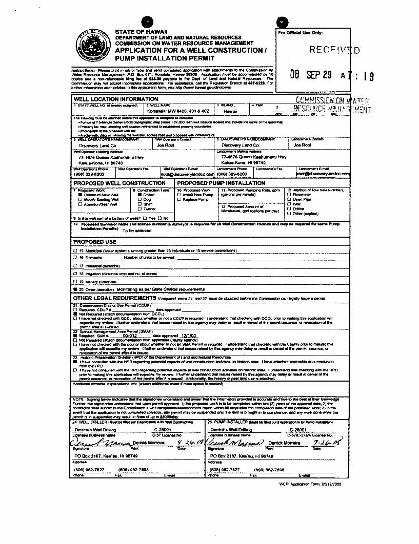
e
• STATE OF HAWAII For 0ftIc;IIII Use Only: DEPARTMENT OF LAND AND NATURAL RESOURCES COMMISSION ON WATER RESOURCE MANAGEMENT
RECF!Vf APPLICA nON FOR A WELL CONSTRUCTION I PUMP INSTALLATION PERMIT
o tnetrucaomI: Pleeee prInI In iN< Of type and MI'Id ~ ~ _ tIIIIIChmInIII 10 !he CommIaIOn on DB SEP 29 A" water Reaoun:a ~, POBox e21, Honolulu, _ 9680Q ~_be~byl0 ooPet and a ~ 1iInO ,.. of SUM ~ \0 tI!e Dept of l.-.cI and NaIuI'. R_ The 19 CommIISiOn may noIlICQIIIII 1!ICIDInIlIeht appIlcatIona For _ ....... CIIIIIht RIIU\AbIln Branch Itt 117.022. FOf ___ and I4ldMM 10 !hi. appIic8Ilon form, IIiIiI htlp/llNwwhawal< govIdInr/c\iWm
WELL LOCATION INFORMATION CeMPIS~IUJ (It.J \ , STATEWEU.NO (If'''"'''''Y''~ 12 weuNAME 3 'm.MIO / rrw 7 I~F'n; ~(C[ }.~~'/J.A (' Kohanaitl MW..w<l, 401 &402 Hawaii -...w
____ ... ,... ... ~ II ... _~ ,"',G
_--.g ...... "" __ "..~I0~ .. ~ '_of1.~_USG$tapOgI'1IIlI1IImop!_'2A,000)"""' _____ "'"_of ... _mop ''''-'Ytu mop, -.u---"-P'-'l'-.~ ................ --.,.-....-"""""""'"_ .... -..--........... --
6 WEu.Of'fRArOffS~ANY ,-Oponiarl ~ 8 lJ\NOOYINER'S ANY I ~.C«CIId
Oiecowry Land Co Joe Root 0isc0Yety Land Co Joe Root
-~.MoIIng-. ~MoIIng-
73-4676 0_ Kaahumanu Hw)' 73-46760_ Kaahumanu Hw)' KaIlua-Kana. HI 967.0 ~Kone,HI96740
-:;'0;:;::;--! WeI Oponiar'.~ .. j..;apo.. .... e,..... I ~- I ~.F .. ~.conj (808) 32U200
~.e._ ~ry\andco.coo
PROPOSED WELL CONSTRUCTION PROPOSED PUMP INSTALLATION 1 P"'flOO8dINoll< 8 CoMI'udIon Type 10~_ 11. Pn:Ipooed Pumping Rille. lIP'" 13 MeIho<I 01_ ",..........,.,nt .Conewet __
• 0fIII0Id a 1 __ Pump
(gallons per-l OF~ OModify~_ DOUg o It..,..,. Pump o Open PIpe o Al:NmdonISeeI WOft o Shaft 12 Pn:IpooedAmomtol _._._- 0_
D r..",.. o 0I1!\Ce 'oIIIIhdr_, gpd (1I"fI<>M PI" dey) [J Other (e>eplilln)
9 ,.!hI.welI part of. betIerY 01_1 0 V ... 0 No I~ I'fopc>Md 8ufwyot _ and _ -/8 ...... Y"" ........... for •• _~ ......... .nd ""'Y be ",,-for_ Pump , .... .-......... ,
TobeMieded
PROPOSED USE
o 15 M~ (Wa18t systems JIIMng gt8IIIer than 25 indMdIIaIs 0( Hj .......,. C'CIIlIIOICItom)
o le~lc _ 01 uniIII to be_'
o 17 ,_ (deIIaIbe)
o 18. In1gaIIOfl I_be crop and no 01 ""'"I
o 111 Mlldary (detIaibe)
• 20 0tMIr ( .. _) Monitoring .. per $!ale CWRM noquiremenls
OTHER LEGAL REQUIREMENTS 1t1f!qUinld."'" 21. 1IfI(/22 muat be _ betonJ the ~ am/ec]lllly _. por1T#I'
21. C_ ollme! U .. Perrnrt (COUP) o R~. COUP II d ______
• NotR~( __ fromOCCl) o 1"- noI ctl4M:Ud WIItI OCCl 8IIOuI ~ Of I'ID4 a COUP is __ I.....,..nd IhaI ~ _ OCCl pnor to ...-..g tI1~ appIICItIIOn.,;u
expecIIIe my......... I,....... undW-.lIheI_ ....... by 1hII_ may ~ or _In_ of !he pormiIl ___ • cr __ 0111-.. """,,"III1efM'._,
22 $pedal MllnlgementA"", PermII {SMAPj • Reqund, SMA. 03-912 ... 8PP'O'I8<I...:l.ZlllU.. o NO! Requfred ( __ from..."..,..,.. County~)
o ,"- not CI1<I(Qoj "'"" !he oounIy _ whether or noIlm SMA -. ~ requIAId I..,.,....., lI1ItI-1nfI _Iht Counly pnor to INkIng IhII appIiC8IlOn wtI e.pecrlle my _ 1 t\JrtIIer uncIaI'-..:t tIleI_.- by IhIIIIIJIIlC¥ may ~ or reautl on denl8I 01 h pennit _. or _ 01 !he p,..",n lifter 1111 j_
23 HIstOrIc Pr.-vatlOn DI'MIon (HPD) of II-.. ~ 01 Land and NoIIInI R_ • 1 h ..... mmouIIe<IwIIh the HPD ~ pcU<1IiIII irrIp8ds 01_ CIlI1OIruc:IIon IICIMII8t on IHIoI1c _ 1 __ ~_
from IhII HPD o 1 _ roc ""'*""" _ h HPO ~ poIoonhIlOI'Ip8CI. 01_ oon ___ "" IHIoI1c _ 1 ~ """-.no _ IN HPD
prIOrI<> "ull<llIO_ ~.,;u~ my _ I "'~~ tIIeI_l1IiIIedby tN1I!IIJIII"ICr may dIIIsy or .... In _ oftl!e ~ -.,.,. 0( _ of IN i>wm« IIfterK Is _ ,., Iht IWolcry oIPMI- ...... _
,., __ . e",*"""""". e1c. ( ____ tmore ..,...II~
NOTE SigNng __ lI1ItIlN ~_ and _thIoIlht-"-"-illlCCUlUlandlnHllolN_oItIMIIr-.tge F..:1tIDr,Iht ... _~IIIItI_pormiIlIpp<O\I8I.l)Iht~_islobe~ __ (21V--0IINej)pI'OWIi""",2JII-.. _tn8lllUllmlltothe C"",mIMIona_ ~~report_'" dap_Iht~ ... of the pormiIIe4WQd<. 3imb _1IIItI1ht ewr- Ie noI ~~. en)' pennII_y be IIUIpIIndIId _IN *"" ill brought into oompIIanoe, and en)' _ done _ IN l~iain~mn""'lln_oIUI>Io'~
2<4 \NElL DRILlER (IIuotbe_ ..... ~IIl.,._~) 25 PUMP INSTALLER 1_ Il0l_ out '1I!>I*IIIOft IO'" Pump-I
_~s WIll DI1IIlng, C-28001 Den1dt'1 Well 0riIh!!i C-28001 ~_ ~ _ "C,!;7 LiCenM No
z:-~ C·57tC·51a1A llOlln1l8 No ~
~" '1:..- ;"'U~"""",DerrickMorreira 9' ~v- ,,( V i:~/1YZtv~:? Oenidt MoneIra . 7·.( ~ Slgnaluf1> PrInt 0 .. SignaUa PM! Dale
PO Box 2187, 1<ea'8U, HI ll67.9 PO Box 2187,1<811'811, HI1l6749 --- I'4dnIA
(808) 982·7627 (808) 982-7698 (808) 982·7627 (808) 982-789S I"tv>ne Fa>. E ...... -- Phone fax 1:;_

PROPOSED WELL SECTION (Please attach schematic if different from diagram provided below)
Hole Oiameter: __ 6 __ in.
Elevation at top of casing ~ II., msl' .:.l.-J:=.: ..... L •• ; ..• :.,. r .... _,I~~ ~~:'e~ ~ ~~:~!~~.~14~.~iCk Concrete Pad (to contain benchmark
~ ~H r GroundElevation: __ 10 __ II.,msl·
Grouting method:
o Positive displacement
• Other
IT otal Depth
~II.
,,/Il00' Cement Grout: _7 __ fl. (min. 70% of distance from ground elevation to top of water surface or 500 ft., whichever is less.)
Annular space between hole and casing (1.5" for positive displacement, 3" for other methods):
__ 2_in.
Rock or Gravel Packing:
N/A II. Material:
o Crushed Basalt
o Rounded Gravel
Estimated Water Level
Elevation:
__ +_1_11. msl' -
.\: "'~" """'" Please refer to the
'. ,. HAWAII WELL CONSTRUCTION AND '-:.; PUMP INSTALLATION' STANDARDS
.:.~,,{.:. to ensure that your as-built is in compliance with applicable standards.
::~:. ". ~.
--'-
Solid Casing: (;, 90% x (Ground Elev.-Water Level Elev))
Total Length: 1 ° ft.
Nominal ~iameter: 2 in.
Wall Thickness: __ --"0"'.1:.::5"'4 ______ in.
Bottom Elevation: +0 II., msl'
Open Casing: 0 Perforated • Screen
Total Length: ___ -=2"'0 _______ 11.
Nominal Diameter: _-'2=--_______ in.
Wall Thickness: 0.154 in.
Bottom Elevation: __ -_20 _____ ft., msl'
note: Neither bentonite nor mud should be used in saturated zone during drilling
Open Hole: Length: _____________ II.
Oiameter: _____________ ,in.
Bottom Elevation: _________ ft., msl'
• The approximate elevation must be referenced to mean sea level (msl) at the time of application filing. Final elevations of well components shall be submitted in the Well CompletionlWell Abandonment reports and referenced to a benchmark which has been established by a surveyor licensed by the State.
For non-5alt water Basal Wells - bottom elevation of well should not be deeper than 1/4 of aquifer thickness or, Bottom Elevation of Well Limit = (water Elevation _ 41 x Water L~el Elevation )
Example: Estimated + 2 ft. Water Level Elev. -+ Bottom Elevation afWeH Limit = (2 _ 41 ~ (2» = ·18.5ft.
Solid Casing Material: Carbon Steel: compliant with (check one or more): 0 ANSI/AWWA C200 0 API Spec. 5L 0 ASTM A53 0 ASTM A139
And compliant with (check one or more): 0 ASTM A242 (or A606) 0 Type E 0 Type S 0 Grade B 0 Other
Steinless Steel: (check one): 0 ASTM M09 (produdion wellS) 0 ASTM A312 (monitor wells) ASS Plastic conforming to ASTM F480 and ASTM D1527: (check one) 0 Schedule 40 0 Schedule 80 PVC Plastic conforming to ASTM F480 and (ASTM D1785 or ASTM 02241 ): (check one): • Schedule 40 0 Schedule 80 0 Schedule 120
Thermoset Plastic: (check one) 0 Filament Wound Resin Pipe conforming to ASTM 02996
o Centrifugally Cast Resin Pipe confonning to ASTM 02997
o Reinforced Plastic Mortar Pressure Pipe conforming to ASTM 03517
o Glass Fiber Reinforced Resin Pressure Pipe conforming to AWWA C950
o PTFE Ruorocarbon Tubing conforming to ASTM 03296
o FEP Fluorocarbon Tubing conforming to ASTM 03296
Open Casing Material: Carbon Steel: compliant with (check one or more): 0 ANSI/AWWA C200 0 API Spec. 5L 0 ASTM A53 0 ASTM A139
And compliant with (check one or more): 0 ASTM A242 (or A606) 0 Type E 0 Type S 0 Grade B 0 Other
Stainless Steel: (check one): 0 ASTM M09 (produdion wells) 0 ASTM A312 (monitor wells)
ABS Plastic conforming to ASTM F480 and ASTM 01527: (check one) 0 Schedule 40 0 Schedule 80
PVC Plastic conforming to ASTM F480 and (ASTM 01785 or ASTM 02241): (check one): • Schedule 40 0 Schedule 80 0 Schedule 120
Thermoset Plastic: (check one) 0 Filament Wound Resin Pipe conforming to ASTM 02996
o Centrifugally Cast Resin Pipe confonning to ASTM 02997
o Reinforced Plastic Mortar Pressure Pipe conforming to ASTM 03517
o Glass Fiber Reinforced Resin Pressure Pipe conforming to AWWA C950
o PTFE Ruorocarbon Tubing conforming to ASTM 03296
o FEP Fluorocarbon Tubing conforming to ASTM 03296
WCPI Application Form 05/12/2005
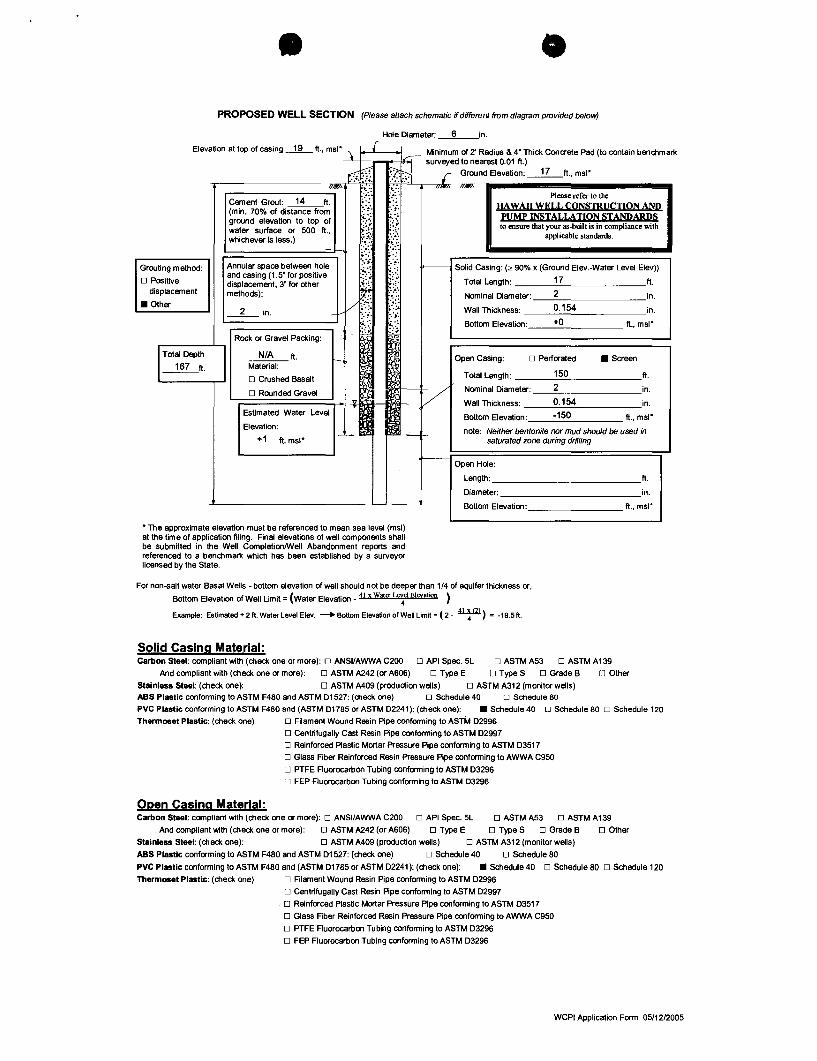
PROPOSED WELL SECTION (Please attach schematic if different from diagram provided below)
Hole Diameter: __ 6 __ in.
Elevation at top of casing ~ ft., msl", ~ r i ~ Minimum of 2' Radius & 4" Thick Concrete Pad (to contain benchmark -.i.1a """' surveyed to nearest 0.01 ft.) t=:"t{ X· ~ r Ground Elevation: __ 17 __ ft., msl"
--nmd-~~ .--_________ ...,//IJI«\. f.:~: .::{: '''~, ,/""'" Please refer to the
~i~,e~~.~r~~ista~~e frO! ("" HAWAII WEI.I, CONSTRUCTION AND ground elevation to top of ;:.',;.' ":.; PUMP INSTALLATION STANDARDS water surface or 500 ft., :-:~:. ~::~ to ensure that your as-built is in compliance with whichever is less,) }' Wi applicable standards.
Grouting method: Annular space between hole and casing (1.5" for positive displacement, 3" for other methods):
::~. '.~.
!-:.: ~.:.: ------- Solid Casing: (2 90% x (Ground Elev.-Water Level Elev»
o Positive 4. J Total Length: 17 ft. displacement
t-:~ .~:: Nominal Diameter: 2 in, V?:.: ;'.: .
:d' :.~.
• Other 2 in. Wall Thickness: __ --'0'-.-'.15.:...4-'-______ in,
L.-;:========~ ;,,:". .i.':' -+- :,.; :,.; Bottom Elevation: ___ +...:O'--____ ft., msl"
Total Depth
~ft.
Rock or Gravel Packing:
N/A ft. Material:
o Crushed Basalt
o Rounded Gravel 'r======;"'I-ur "Ii!I--lil'\\l!- Y
Open Casing: o Perforated • Screen
Total Length: 150 ft.
Nominal Diameter: 2 in.
Wall Thickness: 0.154 in. Estimated Water Level
Elevation: Bottom Elevation: -150 ft., msl"
__ +_1_ft. msl" note: Neither bentonite nor mud should be used in
saturated zone during drilling
Open Hole:
Length: _____________ ft.
Diameter: _____________ in.
--~ Bottom Elevation: ft., msl"
"The approximate elevation must be referenced to mean sea level (msl) at the time of application filing. Final elevations of well components shall be submitted in the Well CompletionlWell Abandonment reports and referenced to a benchmark which has been established by a surveyor licensed by the State.
For non-salt water Basal Wells - bottom elevation of well should not be deeper than 1/4 of aquifer thickness or,
Bottom Elevation of Well Limit = (water Elevation _ 41 x Water L~el Elevation )
Example: Estimated + 2 ft. Water Level Elev. _ Bottom Elevation of Wen Limit = (2. 41 ~ 12l) = ·18.5ft.
Solid Casing Material: Carbon Steel: compliant with (check one or more): 0 ANSIIAWWA C200 0 API Spec. 5L 0 ASTM A53 0 ASTM A 139
And compliant with (check one or more): 0 ASTM A242 (or A606) 0 Type E 0 Type S 0 Grade B 0 Other
Stainless Steel: (check one): 0 ASTM M09 (production wells) 0 ASTM A312 (monitor wells) ABS PlastiC conforming to ASTM F480 and ASTM 01527: (check one) o Schedule 40 D Schedule 80 PVC Plastic conforming to ASTM F480 and (ASTM 01785 or ASTM 02241): (check one): • Schedule 40 D Schedule 80 0 Schedule 120
Thermoset Plastic: (check one) o Filament Wound Resin Pipe conforming to ASTM 02996
o Centrifugally Cast Resin Pipe confonning to ASTM 02997
o Reinforced Plastic Mortar Pressure Pipe conforming to ASTM 03517
o Glass Fiber Reinforced Resin Pressure Pipe confonning to AWWA C950
o PTFE Ruorocarbon Tubing conforming to ASTM 03296
o FEP Fluorocarbon Tubing conforming to ASTM 03296
Open Casing Material: Carbon Steel: compliant with (check one or more): 0 ANSIIAWWA C200 0 API Spec. 5L 0 ASTM A53 0 ASTM A139
And compliant with (check one or more): 0 ASTM A242 (or A606) 0 Type E 0 Type S 0 Grade B 0 Other
Stainless Steel: (check one): 0 ASTM A409 (production wells) 0 ASTM A312 (monitor wells)
ABS Plastic conforming to ASTM F480 and ASTM 01527: (check one) 0 Schedule 40 0 Schedule 60
PVC Plastic conforming to ASTM F460 and (ASTM 01765 or ASTM 02241): (check one): • Schedule 40 0 Schedule 60 0 Schedule 120
Thermoset Plastic: (check one) o Filament Wound Resin Pipe conforming to ASTM 02996
o Centrifugally Cast Resin Pipe confonning to ASTM 02997
o Reinforced Plastic Mortar Pressure Pipe conforming to ASTM 03517
o Glass Fiber Reinforced Resin Pressure Pipe conforming to AWWA C950
o PTFE Ruorocarbon Tubing conforming to ASTM 03296
o FEP Fluorocarbon Tubing conforming to ASTM 03296
WCPI Application Form 05/1212005

PROPOSED WELL SECTION (Please attach schematic if different from diagram provided below)
Hole Diameter: 6 in.
Elevation at top of casing ~ fl .• msl""\ I L Minimum of 2' Radius & 4" Thick Concrete Pad (to contain benchmark ~ ~ --~ surveyed to nearest 0.01 ft.) ~ 7;:;:l r Ground Elevation: __ 25 __ fl., msl"
r----------, "",,"' :.'.:: .':: ."~,, "~,, Cement Grout: 22 fl. ~.~: .:.:
(min. 70% of distance from ::, ~:.; ground elevation to top of ~:.~ water surface or 500 ft., ':;. .:.~.;.'.;. whichever is less.) ~:~:.
~~~. '.~:'.
Please refer to the HAWAII WELL CONSmUCTlON AND
PUMP INSTALLATION STANDARDS to ensure that your as-built is in compliance with
applicable standards.
Grouting method: Annular space between hole and casing (1.5" for positive displacement. 3" for other methods):
::~. .... : 'ot-i'--- Solid Casing: (2 90% x (Ground Elev.-Water Level Elev)) !.:.:
*= V;·;~ - :.,.
o Positive displacement
• Other __ 2_ in.
.: ... Total Length: 25 fl. ;:;::
.. ~:: Nominal Diameter: 2 in . ;.'.;. Wall Thickness: 0.154 in. :. ~.
'-;::=====~+- \ I~ Bottom Elevation: +0 fl., msl"
IT otal Depth
~f1.
Rock or Gravel Packing:
N/A fl. Material:
o Crushed Basalt
o Rounded Gravel
~
V
Open Casing: o Perforated • Screen
Total Length: 20 fl.
Nominal Diameter: 2 in.
Wall Thickness: 0.154 in. Estimated Water Level
Elevation: Bottom Elevation: -20 fl., msl"
note: Neither bentonite nor mud should be used in __ +_1_f1. msl"
I-~ -f-saturated zone during drilling
Open Hole:
Length: ____________ f1.
Diameter: _____________ in.
Bottom Elevation: _________ fl., msl"
"The approxImate elevation must be referenced to mean sea level (msl) at the time of application filing. Final elevations of well components shall be submitted in the Well CompletionlWell Abandonment reports and referenced to a benchmark which has been established by a surveyor licensed by the State.
For non-salt water Basal Wells - bottom elevation of well should not be deeper than 1/4 of aquifer thickness or,
Bottom Elevation of Well Limit = (water Elevation _ 41 x Water ~cl EICVation )
Example: Estimated +2ft. Water Level Elev. _BOtlOmElevatiOnOfWellimit=(2-~) = -18.511.
Solid Casing Material: Carbon Steel: compliant with (check one or more): 0 ANSIIAWWA C200 0 API Spec. 5L 0 ASTM A53 0 ASTM A 139
And compliant with (check one or more): 0 ASTM A242 (or A606) 0 Type E 0 Type S 0 Grade B 0 Other
Stainless Staal: (check one): 0 ASTM M09 (production wells) 0 ASTM A312 (monitor wells) ABS PlastiC conforming to ASTM F480 and ASTM D1527: (check one) D Schedule 40 D Schedule 80
PVC PlastiC conforming to ASTM F480 and (ASTM D1785 or ASTM D2241): (check one): • Schedule 40 D Schedule 80 D Schedule 120
Thermoset Plastic: (check one) D Filament Wound Resin Pipe conforming to ASTM D2996
o Centrifugally Cast Resin Pipe confooming to ASTM D2997
o Reinforced Plastic Mortar Pressure Pipe conforming to ASTM D3517
o Glass Fiber Reinforced Resin Pressure Pipe conforming to AWWA C950
o PTFE Ruorocarbon Tubing confooming to ASTM D3296
o FEP Fluorocarbon Tubing conforming to ASTM D3296
Open Casing Material: Carbon Steel: compliant with (check one or more): 0 ANSIfAWWA C200 0 API Spec. 5L 0 ASTM A53 D ASTM A139
And compliant with (check one or more): 0 ASTM A242 (or A606) 0 Type E 0 Type S 0 Grade B 0 Other
Stainless Staal: (check one): 0 ASTM A409 (production wells) 0 ASTM A312 (monitor wells)
ABS Plastic conforming to ASTM F480 and ASTM D1527: (check one) 0 Schedule 40 0 Schedule 80
PVC Plastic conforming to ASTM F480 and (ASTM D1785 or ASTM D2241 ): (check one): • Schedule 40 0 Schedule 80 0 Schedule 120
Thermoset Plastic: (check one) o Filament Wound Resin Pipe conforming to ASTM D2996
o Centrifugally Cast Resin Pipe confooming to ASTM D2997
o Reinforced Plastic Mortar Pressure Pipe conforming to ASTM D3517
o Glass Fiber Reinforced Resin Pressure Pipe conforming to AWWA C950
o PTFE Ruorocarbon Tubing conforming to ASTM D3296
o FEP Fluorocarbon Tubing conforming to ASTM D3296
WCPI Application Form 05/12/2005
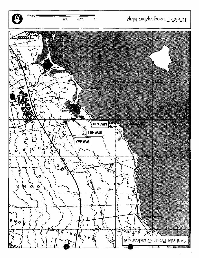
Ie sdllV\J _____ c=:==::::::. __
I o
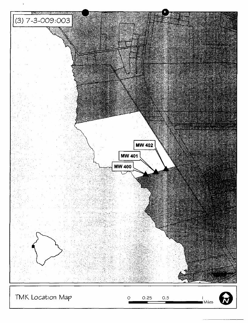
(3) 7-3-009:003
TMK Location Map o 0.25 0.5 I 91 -====== __ Miles
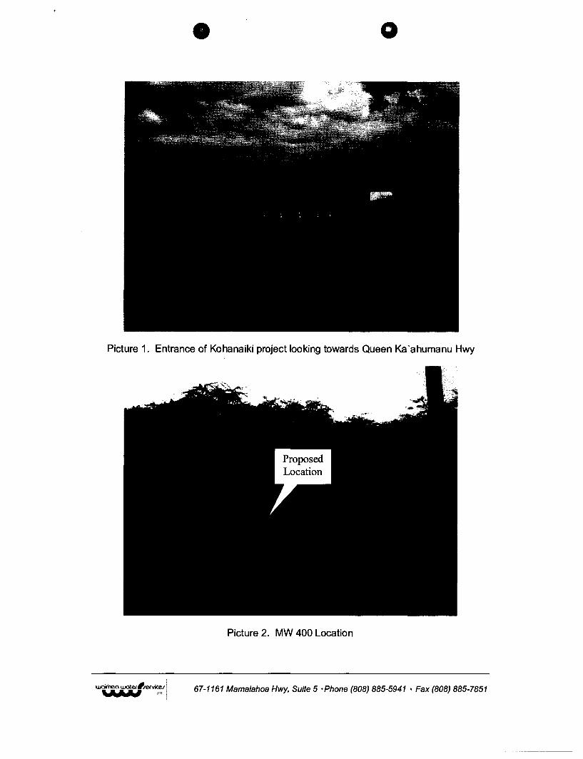
o
Picture 1. Entrance of Kohanaiki project looking towards Queen Ka'ahumanu Hwy
Picture 2. MW 400 Location
67-1161 Mamalahoa Hwy, Suite 5 ·Phone (808) 885-5941 • Fax (808) 885-7851
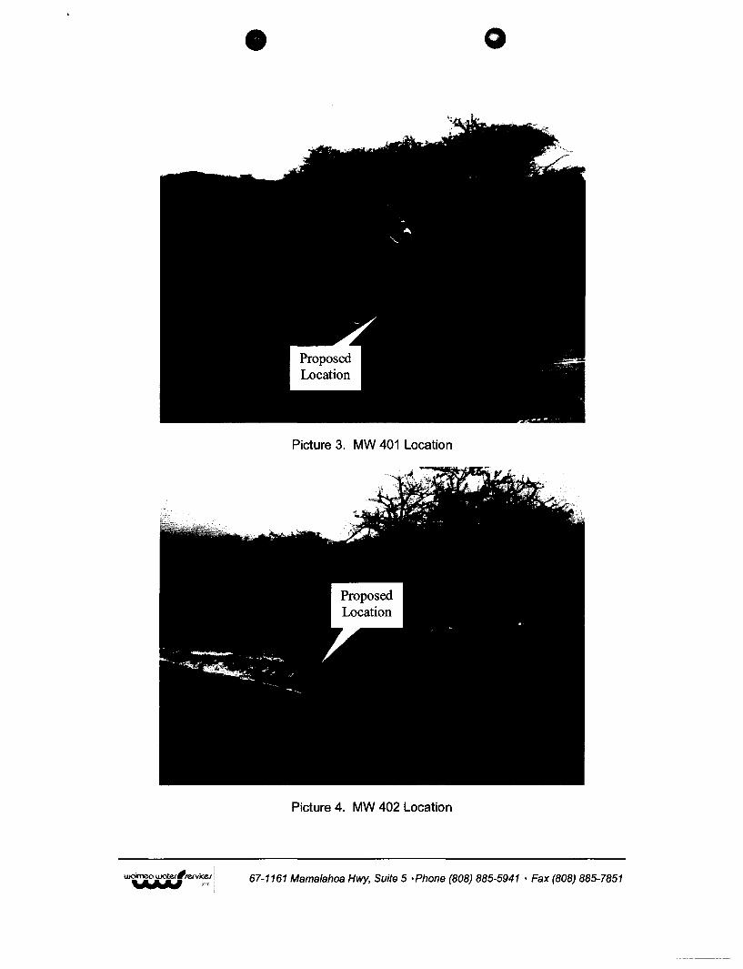
o
Picture 3. MW 401 Location
Picture 4. MW 402 Location
67-1161 Mamalahoa Hwy, Suite 5 ·Phone (808) 885-5941 • Fax (808) 885-7851
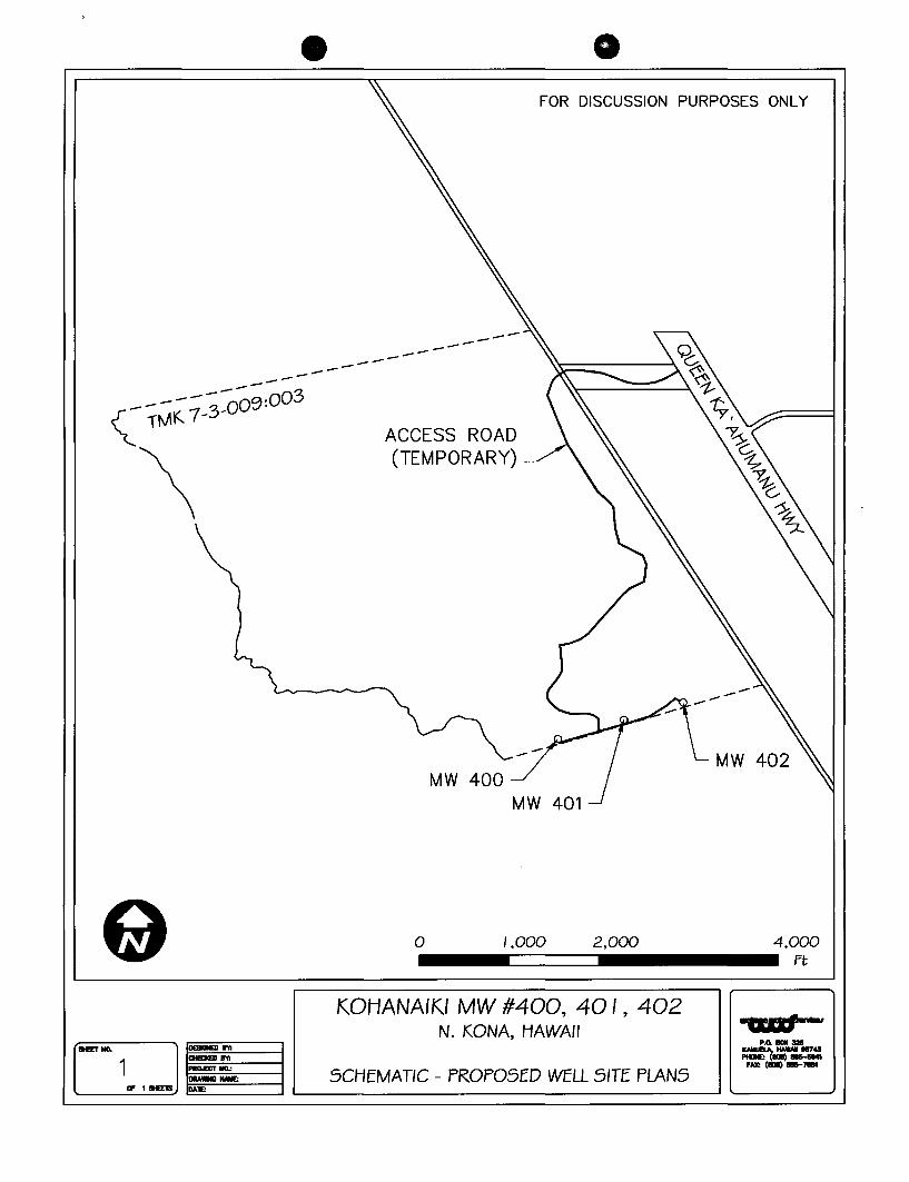
FOR DISCUSSION PURPOSES ONLY
------------_ ------00;;;;3 \ TMK 1-3-
\ ACCESS ROAD (TEMPORARY)
o /,000 2,000 4,000 ___ -=====::::J _______ ft
KOHANAIKI MW #400, 40 I , 402 N. KONA, HAWAII -ca"=-
CJ p.o. __
SIEEr 110. ICMAJBA, HA_ I87Q _ (101) IIIIII-M41 1 fAX: (101) __ 7II1I'I
" 1 atEE1S ~~---i ,-_S_C_H_E_M_A_T_'C_-_P_R_O_P_O_S_E_D_WE_LL_5_'_TE_P_LA_N_S------' '--__ ~
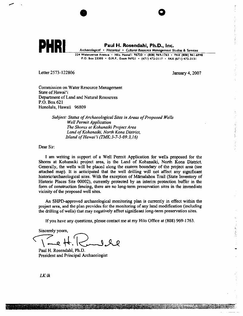
o
PHR Paul H. Rosendahl, Ph.Do, Inco __ -;;-;;--;-A-;:,-;-ch;-a_eo_,o..::.II_CO--;-,_o __ H_/st_o-;-;rlc:;:-o_, -;-;,_c_u:::ltu-:r;:-:o'-=R.;:-:es_o_urc-::e:::-M:::-:::on-:-:o!!-,e:-=m~e::-nt:....S-::tu:7d:-:;'e~s o-::&-:::S..::.:erv,:..:.l.:.;ce:..:.,sc-:-:-_
224 Walanuenue Avenue • Hllo. Hawlll'l 96720 • (808) 969·1763 • FAX (808) 961.6998 P.O. BOl( 23305 • G.M.F •• Guam 96921 • (671) 472·3117 ' FAX (671) 472.lI31
Letter 2573-122806
Commission on Water Resource Management State of Hawai'i Department of Land and Natural Resources P.O. Box 621 Honolulu, Hawaii 96809
January 4, 2007
Subject: Status of Archaeological Sites in Areas of Proposed Wells Well Permit Application
Dear Sir:
The Shores at Kohanaiki Project Area Land of Kohanaiki. North Kona District.
Island ofHawai'; (TMK:3-7-3-09:3.16)
I am writing in support of a Well Permit Application for wells proposed for the Shores at Kohanaiki project area, in the Land of Kohanaiki, North Kona District. Generally, the wells will be placed along the eastern boundary of the project area (see attached map). It is anticipated that the well drilling will not affect any significant historic/archaeological sites. With the exception of Mamalahoa Trail (State Inventory of Historic Places Site 00002), currently protected by an interim protection buffer in the form of construction fencing, there are no long-term preservation sites in the immediate vicinity of the proposed well sites.
An SHPD-approved archaeological monitoring plan is currently in effect within the project area, and the plan provides for the monitoring of any land modification (including the drilling of wells) that may negatively affect significant long-term preservation sites.
If you have any questions, please contact me at my Hilo Office at (808) 969-1763.
Sincerely yours,
C\--R. ~.~.JU Paul H. Rosendahl, Ph.D. President and Principal Archaeologist
LK:lk
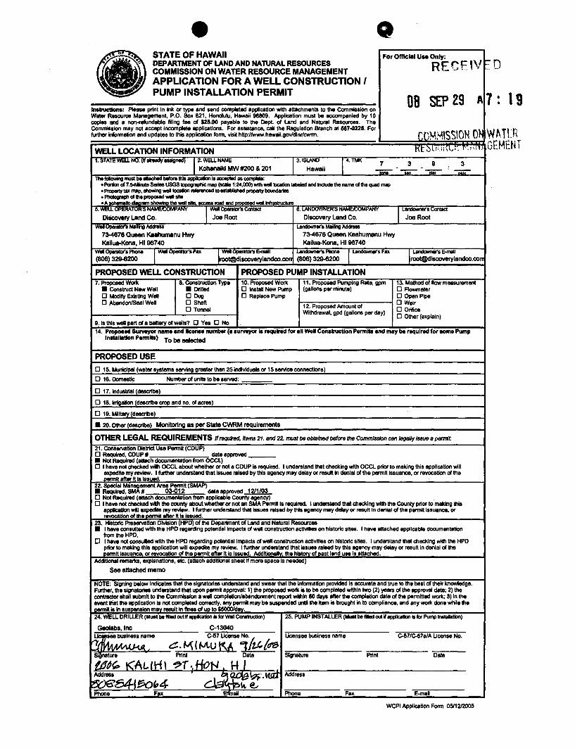
STATE OF HAWAII For OffIcial Use Only: DEPARTMENT OF LAND AND NATURAL RESOURCES RECEJV r-:-COMMISSION ON WATER RESOURCE MANAGEMENT
,.. .. o APPLICATION FOR A WELL CONSTRUCTION I • PUMP INSTALLATION PERMIT
08 SEP 29 A7 19 Instructions: Please print In Ink or type and send completed application with attachments to the CommISsion on Water Resource Management, P.O. Box 621, Honolulu, Hawaii 96809. Application must be accompanied by 10 oopIes and a non-refundable filing fae of $25.00 payable to \he Dept. of Land and Natural Resources. The CommISsion may not accept incomplete applications. For aSSIstance, call the Regulation Branch at 68NI225. For further Information and updates to this appllcatlon form, vis~ hllp:l/www.hawail.gov/dlnr/cwrm. COMMISSION O~ ~ ~~.TLn
EMENT !"
WELL LOCAnON INFORMATION Kt::>\!ili'\.;(' {'Ii,,,,. lJ
1. sTATE WI:LL NO. (R enaay eSSigneo) 12. WELl NAME 3. ISlAND 14, TMK 7 3 9 3 Kohanaiki MW #200 & 201 Hawaii . :
- ..... - 0i0i' ..,.-The fcIIowIng I1'1III be III8ched bofore!hls appIIcaticn Is acc:epIad as compIeI8:
• Pa1Ion d 7.s-MIrUe SerIes USGS topogrIphic map (scale 1 :24,000) with WllllIocaIIan labeled and Include the nama of 1he quad map • Pr-'Ytax "",p, """"""" WllllIoc:a1Ion -...:ad to _!shed ~ boundaries • PhcIograph d the proposed WIllI sitII • A schernaIk: claaram ShowIna the wenoile, ....... road and DrODOSed WIIIIlnfrastructu",
5. WELL OPERATOR'5 NAMEJ{X)Mi'ANY .1 Wei OperaIDr's Contact 6.lANOOVVNER'S NAM~ANY 1 La.-.r's eontacI
Discovary Land Co. Joe Root Discovery Land Co. Joe Root Well upotIIfDf"S Mdfng Address La.-.r'. MaIling Address
73-4678 Queen Kaahurnanu Hwy 73-4878 Queen Kaahurnanu Hwy Kailua-Kona, HI 98740 Kailua-Kona, HI 98740
WeI OperaIDr's Phone I WeI OpenItot's Fax Ir well 0peIe\0t'S &mill ~.Phone I ~sFax II LandownIIr's E-maIl (808) 329-8200 [email protected] (808) 329-8200 [email protected]
PROPOSEDWELLCONSTRUcnON PROPOSED PUMP INSTALLATION 7. Proposed Work 8. Constructton Type 10. Proposed Work 11. Proposed Pumping Rate, gprn 13. Method of flow measurement
• Construct New Well • DrIlled o Instal New Pump (gallons per minute) o Aowmeter o Modify ExIsting Well DDvg o Replace Pump o Open Pipe o AbandonlSael Well o Shafl 12. Proposed Amount of
DWfilr o Tunnel o Orifice Withdrawal, gpd (gallons per day) o Other (explain)
9. Is this well part of a battary of wells? q Yes 0 No 14. Proposed Surveyor name and lice ... number Ce surveyor Is required for all Well Construction Permllll and may be required for aome Pump
1II8telllltlon Permllll) To be selected
PROPOSED USE
o 15. Municipal (weier systems serving greater than 25 individuals or 15 service connections)
o 18. Domestic Number of units to be served:
o 17. Industrial (describe)
o 18. Irrigation (describe crop and no. of acres)
o 19. Military (describe)
• 20. Other (describe) Monitoring as per State CWRM requirements
OTHER LEGAL REQUIREMENTS" requted, /$ms 21. and 22. must be obtained before /he Commission can legally Issue 8 perrrtt:
21. Conservation DIStrict Usa Permit (COUP) o Required, COUP # date approved ___
• Not Required (attach documentation from OCCL) o I have not checked with OCCL about whether or not a COUP Is required. I understand that checking with OCCL prior to making this application will expedite my review. I fuI1her und8r$tand that Issues raised by this agency may delay or result in denial d the permit Issuance, or revocation d the Demllt alter II Is ISsued.
22. Special Mlinagement Area Permit (SMAP) • Required, SMA # 03-012 deteapproved 1211/03 o Not Required (attach documentation from applICable County agency) o I have not checked with the oounty about whether 01' not an SMA Permit Is required. I underStand thBI checking with the County prior to making IhII
application wRl expecIte my review. I further understand that Issues raised by this agency may delay or result In denial of the pennillssuance, or revocation of the--'!!!l'!l1l1 afler 1\ lalSsued.
23. HIStoric: Preservation Division (HPD), of the Department of Land and Natural Resources • I have consulted with the HPD regarding potenUallmpacts of well construction actlvities on hIStoric sites, I have lII\aChed applicable documentation
from \he HPD. q I have not consultad with the HPD regarding potential Impacts of well construction actlvitias on historic slles. I und8r$tand that checking with the HPD
prior to making thIS applICation will expedite my review. I further understand that .sues raised by this agency may delay or result in denial of the permit lSsuar!!:e, 01' revocation d the~ennlt allerll Is issued. Addltionall~ the hlstorv of Dast land use Is attached.
Additional rernar\(S, explanations, etc. (attach additional sheet if more space is needed)
See attached memo
NOTE: Signing below IndICates thBIlhe signatories understand and swear that the Information provided Is accurata and true to the best of their knowledge. Further, the signatoriea understand that upon permit approval: 1) the proposed work IS to be completed within two (2) years of Ihe approval date; 2) the contractor shall submit to the Commission a well completion/abandonment l'8IIO(I within 80 days lifter \he completion data of \he permitted work; 3) In the iMnt ttiat the application is not completed correctly, any permll may be suspended untl the Item Is brought in to compliance, and any work done while tha permit is In suspension mllY result In fines dUD to $5OOOIdav. 24. WELL DRILLER (Must be lllied out W oppIIc:don Is for Well CcnItructIon) 25. PUMP INSTALLER (Must be flied out W appllca\lalls for Pump Instalallcn)
Gaolabs, Inc C-13040 ~ae business name C-57 Ucensa No, Ucensae business name C-57/c-f17a1A Uoanse No.
'UMl LA 4 ~. ~ (Mu KA 11th {dS Slgneture PrInt Data Signature PrInt Data
{dd(P t<A~rH\ .,.r.,HoN H J Address
3~tr\-·'~ Address
~~(~"4 cl.:3 .~ -".
k@.., Phone Fax ~al Phone Fax E-maH
WCPl Application Form 0511212005
STATE OFevAIl DEPARTMENT OF LAND AND NATURAL RESOURCES COMMISSION ON WATER RESOURCE MANAGEMENT
Official Use Only:
APPLICATION FOR A WELL CONSTRUCTION I PUMP INSTALLATION PERMIT RECEIV .0
Instructions: Please print in ink or type and send completed application with attachments to the Commission on Water Resource Management, P.O. Box 621, Honolulu, Hawaii 96809. Application must be accompanied by 10 copies and a non-refundable filing fee of $25,00 payable to the Dept. of Land and Natural Resources. The Commission may not accept incomplete applications. For assistance, call the Regulation Branch at 587-0225. For further infonnation and updates to this application fonn, viSit http://www.hawaiLgov/dlnr/cwnn.
12. Proposed Amount of Withdrawal, gpd (gallons per day)
DB SEP 29
Permits and may be some Pump
Geolabs, Inc
and 22. must be obtained before the Commission can legally issue a permit:
date approved 12/1/03 c..;;.actid.x;j~~iionfiOO1apPlicable County agency)
about whether or not an SMA Pennn is required. I understand that checking with the County prior to making this I further understand that issues raised by this agency may delay or result in denial of the pennit issuance, or
be filled out if application is Installation)
C-13040 Ucensee business name C-57 Ucense No. Ucensee business name C-57/C-57a/A Ucense No.
Signature Print Date Signature Print Date
Address Address
Phone Fax
WCPI Application Form 05/12/2005
I 9
"TIP ,., \.,., \
n~E~n
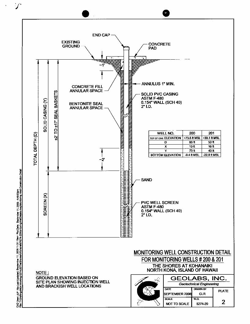
/'
(!) z en ~ o :::i o en
g Z W w rx: () en
NOTE:
en IW ~
~ ~ en i'-..... +I
o I-
~
EXISTING GROUND
END CAP
CONCRETE FILL ANNULAR SPACE
BENTONITE SEAL ANNULAR SPACE
GROUND ELEVATION BASED ON SITE PLAN SHOWING INJECTION WELL AND BRACKISH WELL LOCATIONS
~~-ANNULUS 1" MIN.
SOLID PVC CASING ASTM F-480 0.154" WALL (SCH 40) 2n I.D.
WELL NO. TOPOFCSG ELEVATION
0 X Y
BOTTOM ELEVATION
SAND
PVC WELL SCREEN ASTM F-480 0.154- WALL (SCH 40) 2"I.D.
200 201 +73.6ftMSL +30.1 ft MSL
83ft 53ft 10 ft 10 ft
73ft 43ft -9.4ft MSL -22.9ftMSL
MONITORING WELL CONSTRUCTION DETAIL FOR MONITORING WELLS # 200 & 201
THE SHORES AT KOHANAIKI NORTH KONA, ISLAND OF HAWAII
GEOLABS, INC_ Geotechnical Engineering
DAlE DRAWN BY PLATE
SEPTEMBER 2008 CLR
SCALE w.o. 2

•
TOP OF CSG ELEV 73.59 FT,MSL
'-' z (7j « u 0 ::J 0 (f)
1:'-'
j-.... 0 ~ OJ
END CAP \ METAL ENCLOSURE ~\_-I 6" SQUARE LID
----L-t --- 1-"'-1----.,.;\ -c-
0.53' i
PVC CASING t t THICK, 2r' 1.0. ~" 2.63'
~
~--------------------+~ \l WATER LEVEL ELEV. = 2.38 FT,MSL
(f) z o F « n::: o u.. n::: w 0....
1:'-'
~ @ 3: 03 PM (9/23/08)
ELEV. = -10.48 FT,MSL
NOT TO SCALE SUBJECT TO FlEW ADJUSTMENT
_IlL: --
KOHANAIKI MW #200 3-7 -3-009 :003
N. K.ONA, HAWAII
MONITORING WELL AS-BUILT ~IIIL 1 c:::=:=-::::.~. --f WtHm =_=~ ______ ~ ~ ________________________________________ ~ ~ ________ ~
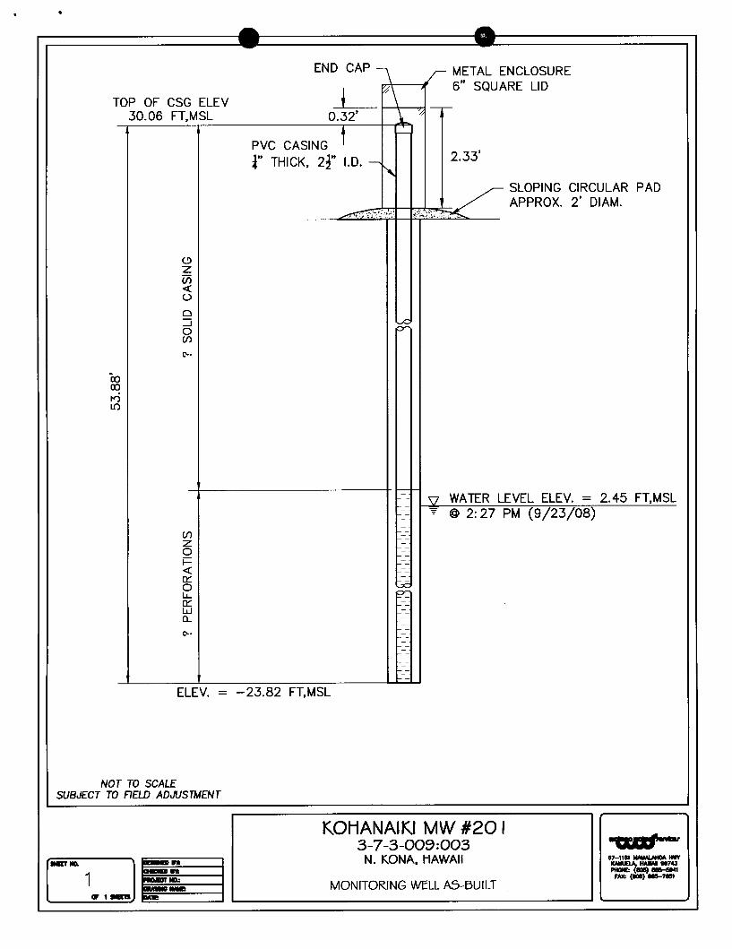
•
Co 0Cl 1'0 If)
e" Z U) « ()
0 ::J 0 (f)
t'-.
END CAP" ."..,\----JI t r:r
I--
~
METAL ENCLOSURE 6" SQUARE LID
2.33'
SLOPING CIRCULAR PAD APPROX. 2' DIAM.
~--------------------+-\l WATER LEVEL ELEV. = 2.45 FT,MSL ~ @ 2: 27 PM (9/23/08)
(f)
z o F « 0::: o lL. 0::: W 0...
t'-.
ELEV. = -23.82 FT,MSL
NOT TO SCALE SUBJECT TO FIELD ADJUSTMENT
KOHANAIKI MW #20 I 3-7 -3-009 :003 fJ&IIJtI • ..,
..rIlL 1 _n MONITORING WELL AS-BUILT "::<J::):':: ~ ~ N. KONA, HAWAII .~~':"
.tHm::-~ ~ ______________________________________ ~ ~ ______ -J
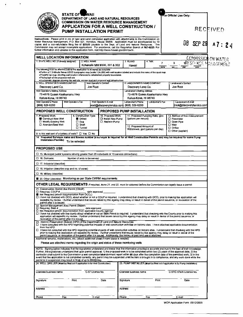
• STATEOF&AII Official Use Only: DEPARTMENT OF LAND AND NATURAL RESOURCES COMMISSION ON WATER RESOURCE MANAGEMENT APPLICATION FOR A WELL CONSTRUCTION I REC ~ ~ PUMP INSTALLATION PERMIT IVFn
Instructions: Please print in ink or type and send completed application with attachments to the Commission on Water Resource Management. P.O. Box 621. Honolulu. Hawaii 96809. Application must be accompanied by 10 DB SEP ZS copies and a non-refundable filing fee of $25.00 payable to the Dept. of Land and Natural Resources. The Commission may not accept incomplete applications. For assistance. call the Regulation Branch at 587-0225. For further information and updates to this application form. visit http://www.hawaii.gov/dlnr/cwrm.
WELL LOCATION INFORMATION COHHISS/Ci 1. STATE WELL NO. (if already assigned) 12. WELL NAME 3. ISLAND 14. TMK 7 3 d~FS(:' '3/('C I .1
Kohanaiki MW#300. 301 & 302 Hawaii -- -- "' ... t,. ut. < 1-' mne .. c "'Oiai narc
The following must be attached before thiS appication is accepted as complete: oPortion of 7.5-Minute Series USGS topographic map (scale 1 :24.000) with well location labeled and include the name of the quad map • Property tax map, showing well location referenced to established property boundaries • Photograph of the proposed well site oA schematic diaqram showina the well sKe, access road and orooosed well Infrastructure
5. WELL OPERATOR'S NAME/COMPANY 1 Well Operato(s Contact 6. LANDOWNER'S NAME/COMPANY 1 Landowner's Contact
Discovery Land Co. Joe Root Discovery Land Co. Joe Root Well Operato(s Mailing Address Lando".,er's Mailing Address
73-4676 Queen Kaahumanu Hwy 73-4676 Queen Kaahumanu Hwy
Kailua-Kona. HI 96740 Kailua-Kona, HI 96740
Well Opereto(s Phone I Well Operato(s Fax I, Well Operator's E-mail Landowner's Phone I Landowne(s Fax II Landowner's E-mail (808) 329-6200 [email protected] (808) 329-6200 [email protected]
PROPOSED WELL CONSTRUCTION PROPOSED PUMP INSTALLATION 7. Proposed Work 8. Construction Type 10. Proposed Work 11. Proposed Pumping Rate. gpm 13. Method of flow measurement
• Construct New Well • Drilled o Install New Pump (gallons per minute) o Rowmeter o MOdify Existing Well o Dug o Replace Pump o Open Pipe o Abandon/Seal Well o Shaft
12. Proposed Amount of o Weir
o Tunnel o Orifice Withdrawal, gpd (gallons per day) o Other (explain) 9. Is this well part of a battery of wells? 0 Yes o No
14. Proposed Surveyor name and license number (a surveyor is required for all Well Construction Permits and may be required for some Pump Installation Permits)
To be selected
PROPOSED USE
o 15. Municipal (water systems serving greater than 25 individuals or 15 service connections)
o 16. Domestic Number of units to be served:
o 17. Industrial (describe)
o 18. Irrigation (describe crop and no. of acres)
o 19. Military (describe)
• 20. Other (describe) Monitoring as per State CWRM requirements
OTHER LEGAL REQUIREMENTS If required. Hems 21. and 22. must be obtained before the Commission can legally issue a permit:
21. Conservation District Use Permit (CDUP) o Required, CDUP # date approved ____ • Not Required (attach documentation from OCCL) o I have not checked with OCCL about whether or not a CDUP is required. I understand that checking with OCCL prior to making this application will
expedite my review. I further understand that issues raised by this agency may delay or result in denial of the permit issuance, or revocation of the permit after it is issued.
22. Special Management Area Permit (SMAP) o Required, SMA # date approved ____ o Not Required (attach documentation from applicable County agency) o I have not checked with the county about whether or not an SMA Permit is required. I understand that checking with the County prior to making this
application will expedite my review. I further understand that issues raised by this agency may delay or result in denial of the permit issuance, or revocation of the permit after it is issued.
23. Historic Preservation Division (HPD) of the Department of Land and Natural Resources 0 I have consulted with the HPD regarding potential impads of well construction activities on historic sites. I have attached applicable documentation
from the HPD. 0 I have not consulted with the HPD regarding potential impads of well construdion adivities on historic sites. I understand that checking with the HPD
prior to making this application will expedite my review. I further understand that issues raised by this agency may delay or result in denial of the permit issuance, or revocation of the permtt after it is issued. Additionally. the history of past land use is attached.
Additional remarks. explanations. etc. (attach additional sheet if more space is needed)
Please see attached memo regarding the origin and status of these monitoring wells
NOTE: Signing below indicates that the signatories understand and swear that the information provided is accurate and true to the best of their knowledge. Further. the signatories understand that upon permtt approval: 1) the proposed work is to be completed within two (2) years of the approval date; 2) the contrador shall submit to the Commission a well completion/abandonment report within 60 days after the completion date of the permitted work; 3) in the event that the application is not completed correctly, any permit may be suspended until the item is brought in to compliance. and any work done while the permit is in suspension may result in fines of up to $5000/day.
24. WELL DRILLER (Must be filled out if application is for Well Construction) 25. PUMP INSTALLER (Must be filled outif application is for Pump Installation)
Ucensee business name C-57 Ucense No. Ucensee business name C-57/C-57a/A Ucense No.
Signature Print Date Signature Print Date
Address Address
Phone Fax E-mail Phone Fax E-mail
WCPI Application Form 05/12/2005
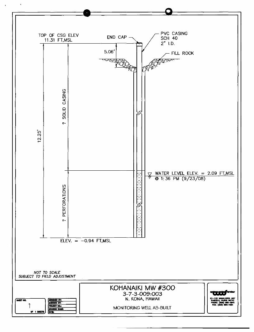
TOP OF CSG ELEV 11.31 FT,MSL
(9
z Ul <t: U
0 ::J 0 Ul
1.'-.
in N N .-
END CAP
5.06'
~
-PVC CASING SCH 40 2" I.D.
/ FILL ROCK
.../EF"''-'' ",fi P-
~--------------------+~ 52 WATER LEVEL ELEV. = 2.09 FT,MSL
(f)
z o i= <t: 0::: o lL.. 0::: W 0....
1.'-'
~ @ 1: 36 PM (9/23/08)
ELEV. = -0.94 FT,MSL
NOT TO SCALE SUBJECT TO FIELD ADJUSTMENT
KOHANAIKI MW #300 3-7 -3-009 :003
.aT III. ~;,.;:IIIILI ;;;;:----1 1 E_==I==_---t MONITORING WELL AS-BUILT
... , . ..., 17-"" __ tIllY
ICAIIUELA, HA_ 111743 -(..,---FAX: (", __ 7851 D -,- N.KONA,HAWAII
~tHm ~ ~ ______________________________________ ~ ~ ______ ~
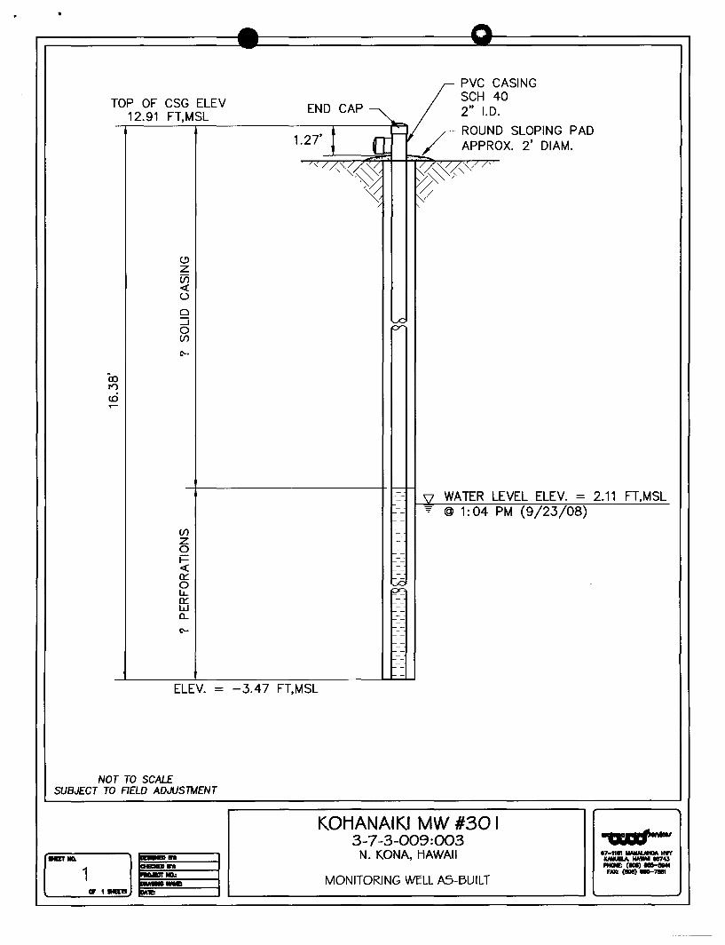
•
PVC CASING
T OP OF CSG ELEV SCH 40
12.91 FT,MSL END CAP 2" 1.0.
1.27' : IT roo- / ROUND SLOPING PAD
APPROX. 2' DIAM. ~ "/ /",,«~ ~~"",/ /'
.~
?/ "\
e" Z U) <{ 0
0 :::J ~ 0 (f)
t'-.
-=-- \l WATER LEVEL ELEV. = 2.11 --
@ 1: 04 PM (9/23/08) -~ --
--
(f) --
-z -0
-- -
F - -<{ -
-a:::: -
0 ~ LL a:::: - -w - -0... - --
-t'-. - --
--
-- -- -- -
ELEV. = -3.47 FT,MSL
NOT TO SCALE SUBJECT TO RELD ADJUSTMENT
KOHANAIKI MW #30 I 3-7 -3-009:003
HlTIIQ. 1 MONITORING WEll AS-BUILT
FT,MSL
~ N. KONA, HAWAII
.1Hm ~ ______ ~ ~ ______________________________________ ~ ~ ________ ~
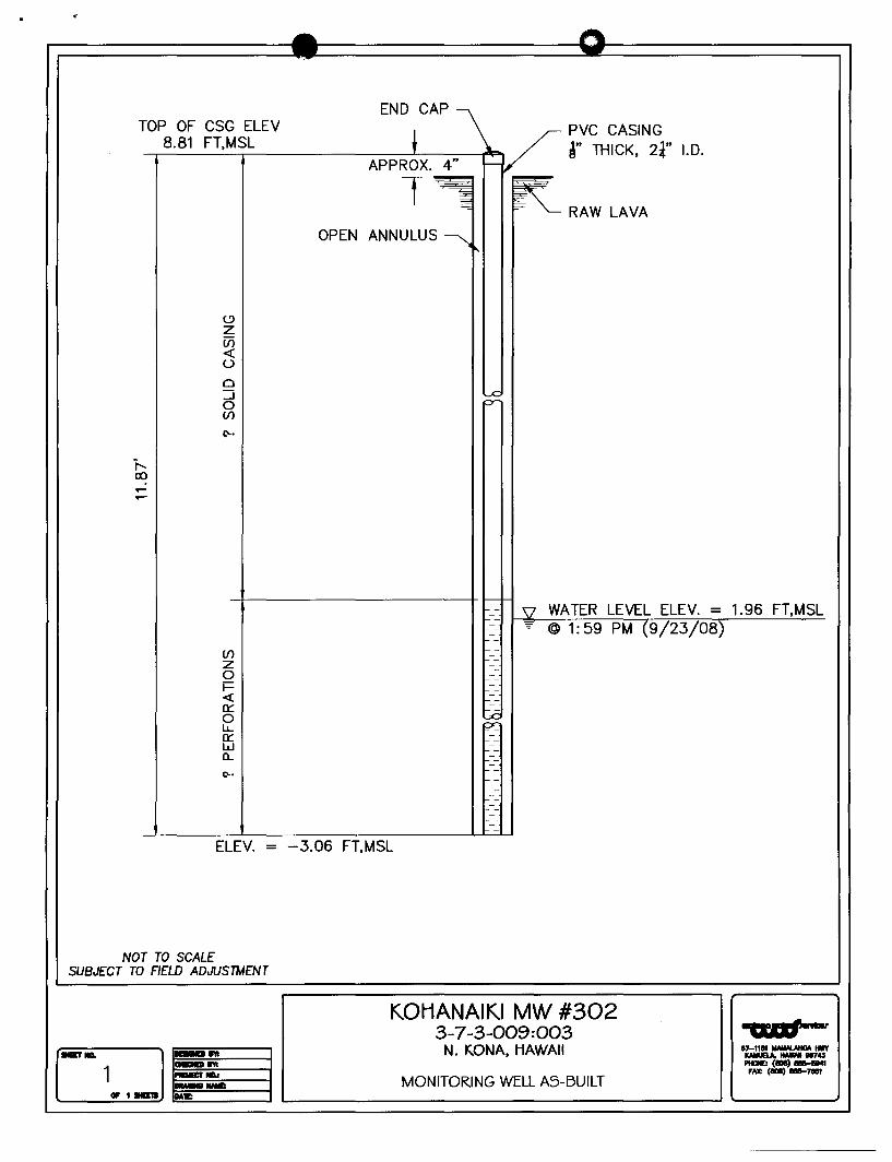
TOP OF CSG ELEV 8.81 FT,MSL
~ z Vi « u o ::J o (/)
(;'0.
(/) z o F « 0::: o lL. 0::: W a..
OPEN
PVC CASING r THICK, 2~" 1.0.
RAW LAVA
WATER LEVEL ELEV. = 1.96 FT,MSL @ 1: 59 PM (9/23/08)
ELEV. = -3.06 FT,MSL
NOT TO SCALE SUBJECT TO FIELD ADJUSTMENT
KOHANAIKI MW #302 3-7 -3-009 :003
D N. KDNA, HAWAII
IlllETIIII. 1 c=:=::::",.---I MONITORING WELL AS-BUILT .1Hm ~ ______________________________________ ~ ~ ______ -J
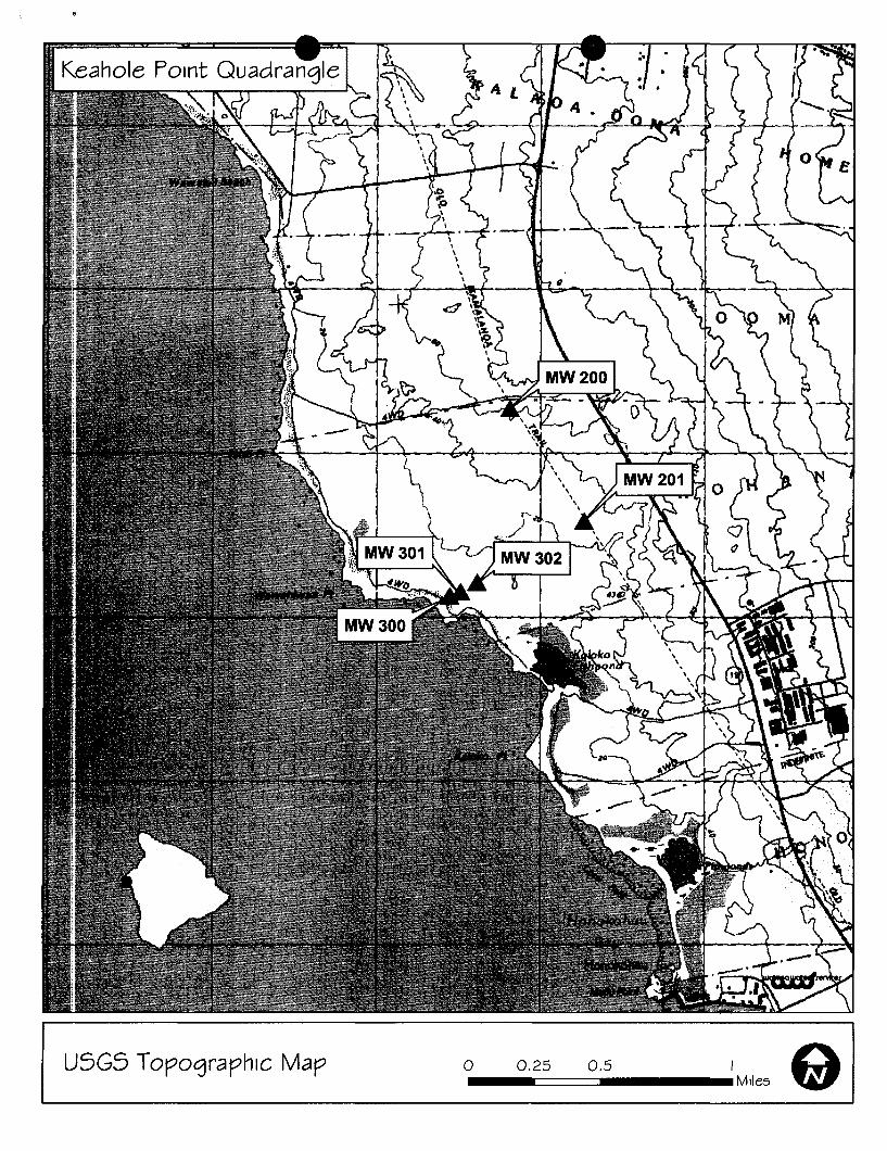
USGS Topographic Map o 0.25 0.5 I 91 -======-_Mlles
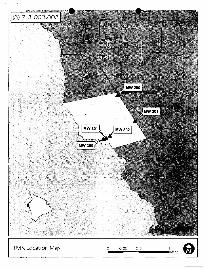
(3) 7-3-009:003
TMK Location Map o 0.25 0.5 I 91 -=====:::l __ Mlles
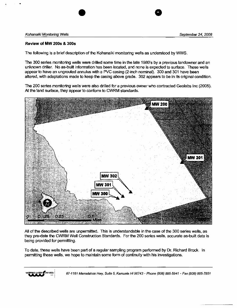
Kohanaiki Monitoring Wells September 24, 2008
Review of MW 2005 & 3005
The following is a brief description of the Kohanaiki monitoring wells as understood by WWS.
The 300 series monitoring wells were drilled some time in the late 1980's by a previous landowner and an unknown driller. No as-built information has been located, and none is expected to surface. These wells appear to have an ungrouted annulus with a PVC casing (2-inch nominal). 300 and 301 have been altered, with adaptations made to keep the casing above grade. 302 appears to be in its original condition.
The 200 series monitoring wells were also drilled for a previous owner who contracted Geolabs Inc (2005). At the land surface, they appear to conform to CWRM standards.
All of the described wells are unpermitted. This is understandable in the case of the 300 series wells, as they pre-date the CWRM Well Construction Standards. For the 200 series wells, accurate as-built data is being provided for permitting.
To date, these wells have been part of a regular sampling program performed by Dr. Richard Brock. In permitting these wells, we hope to maintain some form of continuity with his investigations.
67-1161 Mamalahoa Hwy, Suite 5, Kamuela HI 96743 • Phone (808) 885-5941 • Fax (808) 885-7851
Kohanaiki 300s Monitoring Wells September 24, 2008
MW300
No grout is apparent at the land surface, only some fairly compact rock fill. The original casing is below grade and an unknown length of schedule 40 pipe has been adapted to it.
Picture 1. View of MW 300 looking north
Picture 2. View of MW 300 looking north
67-1161 Mamalahoa Hwy, Suite 5, Kamuela HI 96743 • Phone (808) 885-5941 . Fax (808) 885-7851
Kohanaiki 300s Monitoring Wells September 24, 2008
MW301
As with MW 300, a length of PVC has recently been adapted to the original casing. The cement visible in these photos was also a recent addition, used to secure the new piping.
Picture 3. View of MW 301 looking west, with a drain box resting on cap
Picture 4. View of MW 301 looking north
67-1161 Mamalahoa Hwy, Suite 5, Kamuela HI 96743 • Phone (808) 885-5941 • Fax (808) 885-7851
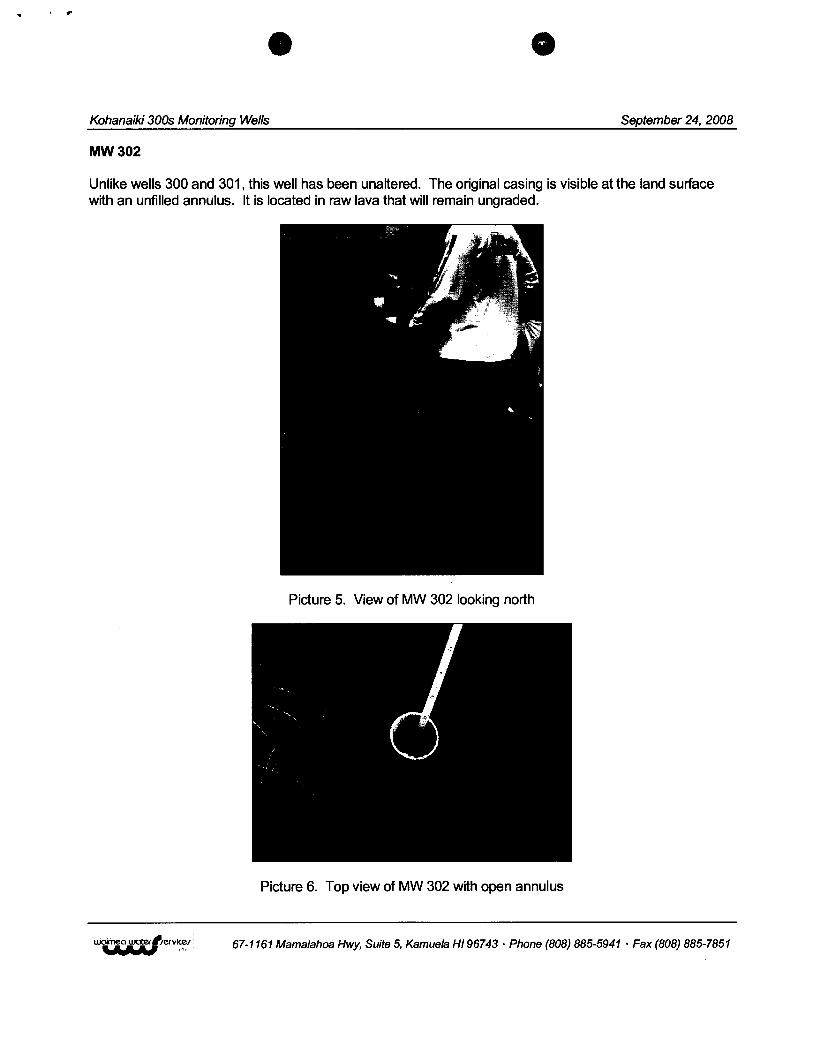
Kohanaiki 300s Monitoring Wells September 24, 2008
MW302
Unlike wells 300 and 301, this well has been unaltered. The original casing is visible at the land surface with an unfilled annulus. It is located in raw lava that will remain ungraded.
Picture 5. View of MW 302 looking north
Picture 6. Top view of MW 302 with open annulus
67-1161 Mamalahoa Hwy, Suite 5, Kamuela HI 96743 • Phone (808) 885-5941 • Fax (808) 885-7851
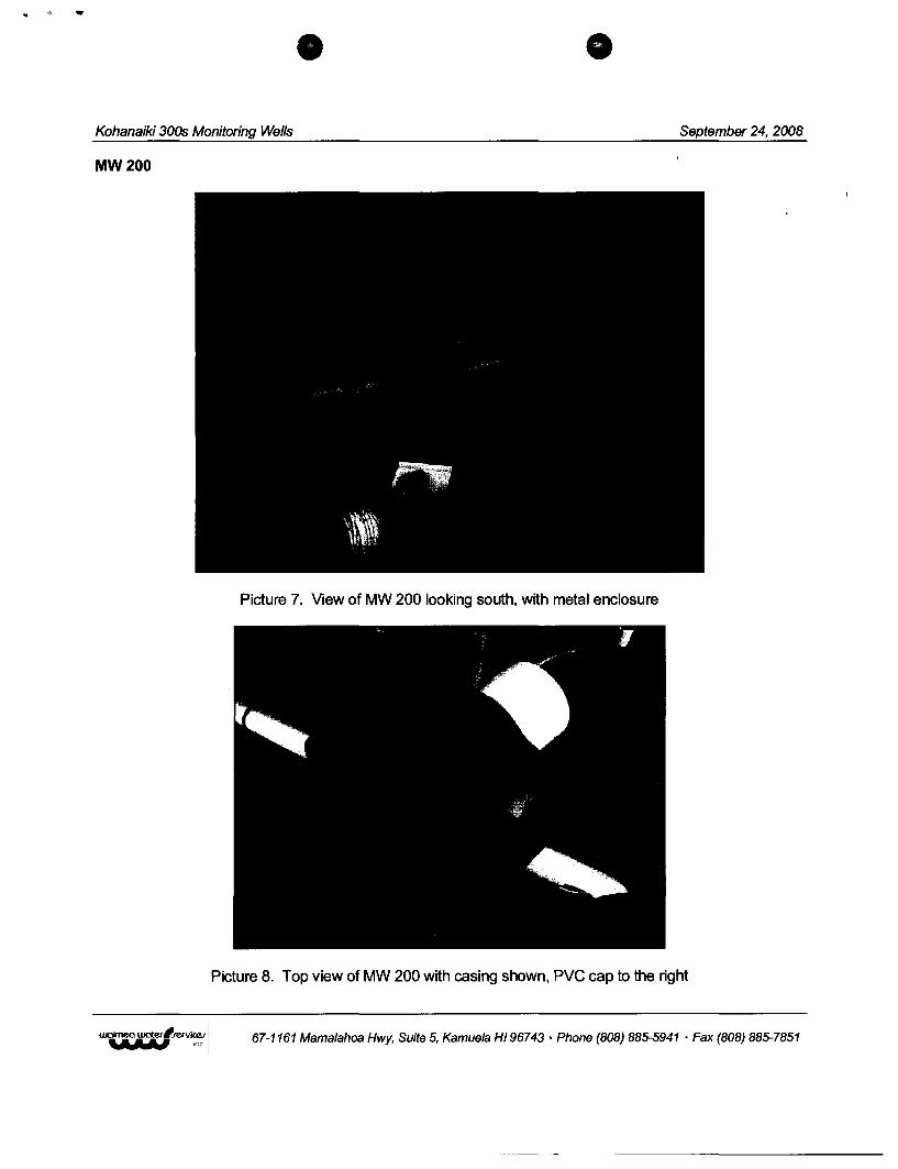
..
Kohanaiki 300s Monitoring Wells September 24, 2008
MW200
Picture 7. View of MW 200 looking south. with metal enclosure
Picture 8. Top view of MW 200 with casing shown. PVC cap to the right
67-1161 Mamalahoa Hwy, Suite 5, Kamuela HI 96743 . Phone (808) 885-5941 • Fax (808) 885-7851
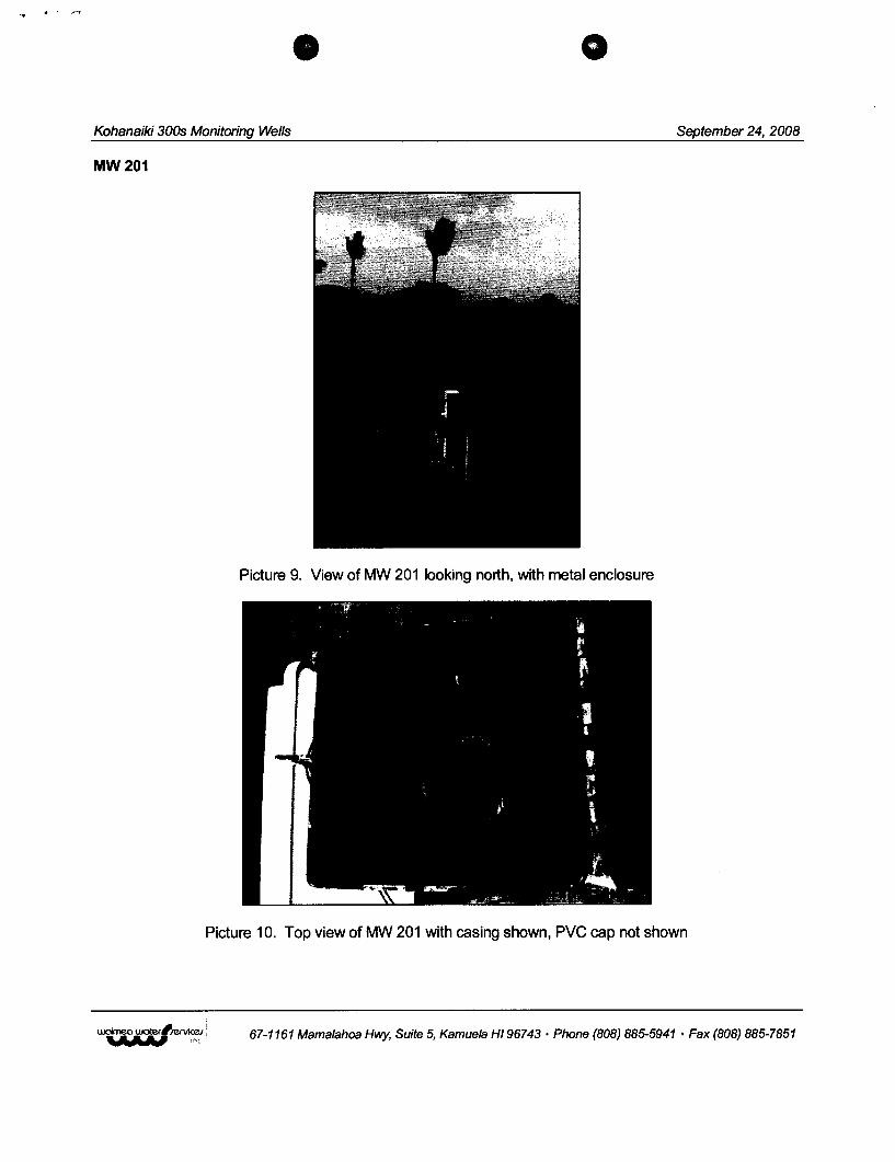
Kohanaiki 300s Monitoring Wells September 24, 2008
MW201
Picture 9. View of MW 201 looking north, with metal enclosure
Picture 10. Top view of MW 201 with casing shown, PVC cap not shown
67-1161 Mamalahoa Hwy, Suite 5, Kamuela HI 96743 • Phone (808) 885-5941 • Fax (808) 885-7851
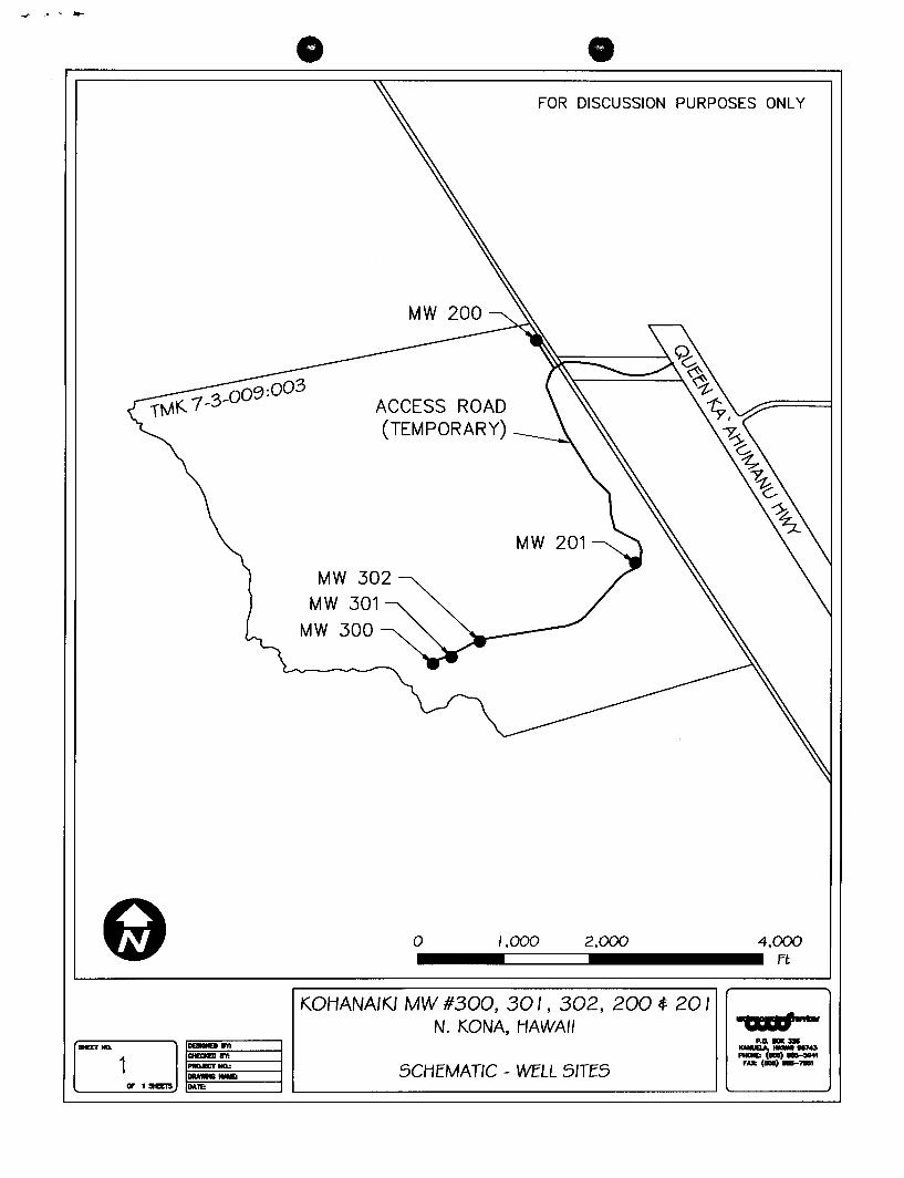
FOR DISCUSSION PURPOSES ONLY
ACCESS ROAD (TEMPORARY)
MW 302
MW 301
MW 300
MW 201
a /,000 2,000 4,000 ___ -======-______ ft
KOHANAIKI MW #300, 30 I , 302, 200 ~ 20 I N. KONA, HAWAII
D P.o. __
IHET NIL -.-. ""_ 1874.11 -1..,---1 SCHEMATIC _ WELL SITES FAX: 1"' __ 7IIBI
!IF 1 stEElS ~=------f L-___________ --' '--__ ~