


Talen
Pages
Wettelijk

ONTARIO INTLAIRPORT
CABLEFIELD
RIALTO AIRPORT
63rd District
59th District
62nd District61st District
66th District71st District
SIERRA AVE
CITR
US AVE
4TH ST
CHERRY AVE
SLOVER AVE
VALLEY BLVD
STATE HWY 83
ARCHIBALD
AVE
LYTLE CREEK RD
JURUPA ST
BANYAN ST
JURUPA AVE
E 4TH ST
ALDER AVE
SAN BERNARDINO AVE
EAST AVE
N EU
CLID
AVE
RAMONA AVE
E HOLT BLVD
W ARROW HWYMERRILL AVE
W 8TH ST
E PHILADELPHIA ST
SUMMIT AVE
GLEN H
ELEN
PKWY
WILSON AVE
SAPPHIRE ST
FONTANA AVE
S MILLIKEN
AVEW HOLT BLVD
GLENDORA RI
DGE RD
W PHILLIPS ST
MOUNT BALDY RD
N VIN
EYARD AVE
W 16TH ST
W MISSION BLVD
ARMSTRONG RD
PHILADELPHIA STS AR
CHIBALD
AVE
DEVO
RE R
D
KENWOOD AVE
SAN BERNARDINO ST
ILEX ST
W 25TH ST
W BASE LINE RD
MULBER
RY AVE
W COAST BLVD
S CENTRAL AVE
ALMOND ST
SHINN RD
BOHNERT AVE
N HAVEN
AVE
TURQUOISE AVEM
OUNTAIN
LN
W RIALTO AVE
ALDER ST
LOCUST AVE
RED HILLCC
UPLAND HILLSGC
ONTARIO AIRPORTAIR GUARD STA
S a n B e r n a r d i n o N a t i o n a l F o r e s tA n g e l e s N a t i o n a l F o r e s t
AngelesNationalForest
San Bernardino National Forest
Ontario
Fontana
UplandRancho Cucamonga
Rialto
Montclair
Chino Glen Avon
Claremont
Bloomington
San Antonio Heights
Sunnyslope
GLEN HELENREG PARK
CUCAMONGAGUASTIREG PARK
RED HILLPARK
BERYLPARK
RANCH CUCAMONGA PARK
HERITAGEPARK
JOHNGALVINPARK
JOHN GALVINPARK
COLONYPARK
JUNIPERPARK
NORTHHERITAGEPARK CYPRESS
PARK
SARATOGAPARK
OLIVEDALE PARK
SANANTONIOPARK
HERMOSAPARK
WINDROWSPARK
GREENBELTPARK
SEVILLEPARK
VICTORIAGROVESPARK
ALMA HOFFMANPARK
SAN ANTONIOPARK
MAGNOLIAPARK CIRCLE
PARK
BALDY VIEWPARK
30
3030
6060
83
83
10
1010
15
15
6666
I-10
E 8th St
San Bernardino Ave
Lytle Creek Rd
Cajon Blvd
Cucamonga Creek
Arrow Rte
S Benson Ave
Claremont Blvd
N Riverside Ave
Whittram Ave
Highland Ave
Sierra AveN Mountain Ave
E Richland St
Beech Ave
Big Tree Truck Rd
Foothill Blvd
Benson Ave
Douglas Ave
WinevilleAve
N Central Ave
W 9th St N Grove Ave
E Terrac
e Ln
0 1 2
Miles
Assembly District 63West Part
Map 1 of 4
Riverside
San Diego
San Bernardino
M E X I C O
Orange
80
65
66
34
64
73
75
74
70
76
54 67
Imperial
Los Angeles
77
59
71
36
63
60
79
38
62
78
61
44
72
5743
5556
68
49
53
69
42
P
ac
if
ic
Oc
ea
n
MappedArea
Legend
Assembly Boundary
State Boundary
County Boundary
City Boundary
Major Highway
Other Highway
Other Road
Railroad
Outside District
Major Landmarks
Institutions
ST BERNARDINEMED. CNTR.
MOUNTAIN VIEWCEMETERY
PIONEER MEMORIAL
CEM
SAN BERNARDINO
COMM. HOSP.A
RR
OW
HE
AD
CC
EL RANCHOVERDE GC
SHANDIN
HILS
GC
CAL STATE UNIVSAN BERNARDINO
SAN BERNARDINOCOUNTY HOSP
WILDWOODPARK
LAKE GREGORYREG PARK
PERRIS HILLPARK
BLAIRPARK
SECCOMBELAKE REC AREA
ENCANTOPARK
SWITZERPARK
HUDSONPARK
GUTIERREZPARK
San ManuelReservation
San Bernardino Nat ional Forest
San BernardinoNational Forest
San Bernardino Nat ional Forest
SAN BERNARDINOINTERNATIONAL
AIRPORT
San Bernardino Highland
Rialto
Crestline
Muscoy
Lake Arrowhead
W Kendall Dr
N C
alifornia St
Pacific St
Alabam
a St
Cable
Cre
ek C
hann
el
W 27th St
June
St
Golondrina D
r
N F
lores St
W 26thSt N
Medical
Center D
r
Lytle CajonCreek
19th St
Roberts S
tJune Pl
Court St
N E
lmw
ood Rd
Alam
o St
N M
adison St
Baseline St
Pasito St
Leslie St
Del
Ros
a Dr
Cajon Blvd
Cypress St
Monte
Vista D
r
Warm C
reek
Tippecanoe A
ve
Lincoln Dr
Muscupiabe D
r
W 40 St
Boulder Ave
Eureka St
Palm
Ave
N W
aterman A
ve
Marshall Blvd
39th St
San
d C
reek
E 40th St
Mirada St
Mou
ntai
n A
ve
Stanton A
ve
Date St
E 41st St
Highland Ave
Citrus St 29th St
N L
eroy
St
N M
ount
ain
Ave
Lynwood Dr
Monte Vista D
r
Bly
the
Ave
59th District
62nd District
63rd District
5TH ST3RD ST
N E
ST
N H
ST
N S
IER
RA
WAY
ST
ER
LING
AV
E
N S
TATE
ST
VIC
TOR
IA A
VE
RIALTO AVE
RO
SA
AV
E
HA
RR
ISO
N S
T
VA
LEN
CIA
AV
E
W HIGHLAND AVE
N W
ATE
RM
AN
AV
E
E RIALTO AVE
6TH ST
30TH ST
5TH ST
PE
PP
ER
AV
E
13TH ST
WATER DR
W 27TH ST
UN
IVE
RS
ITY
PK
WY
4TH ST
N A
RR
OW
HE
AD
AV
EN
MO
UN
TAIN
VIE
W A
VE
CH
UR
CH
AV
E
MU
SC
OT
T S
T
BELMONT AVE
PIN
E A
VE
FOOTHILL DR
2ND ST
OR
AN
GE
ST
G S
T
BASELINE RD
3RD ST
E S
T
MO
UN
T
VE
RN
ON
AV
E
RIV
ER
SID
E A
VE
215
215
30
18
138
18
173
30
30
330
189
18
MANZANITA DR LAKE DRLAKE GREGORY DR
RIVERSIDE AVE
66
NORTHPARK BLVD
LITTLEM
OU
NTA
IND
R
ELE
CT
RIC
AV
E
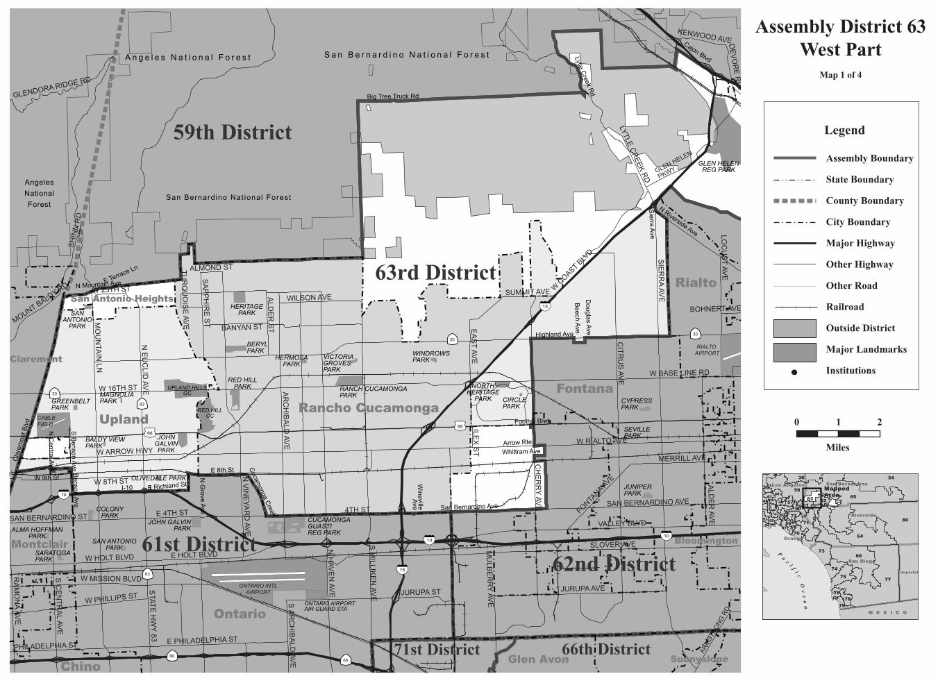
Assembly District 63Central Part
Map 2 of 4
0 1
Miles
2
R i v e r s i d e
San Diego
San Bernardino
M E X I C O
Orange
80
65
66
34
64
73
75
74
70
76
54 67
Imperial
Los Angeles
77
59
71
36
63
60
79
38
62
78
61
44
72
5743
5556
68
49
53
69
42
P
ac
if
ic
Oc
ea
n
MappedArea
Legend
Assembly Boundary
State Boundary
County Boundary
City Boundary
Major Highway
Other Highway
Other Road
Railroad
Outside District
Major Landmarks
Institutions
HILLSIDECEMETERY
YUCAIPAH.S.
REDLANDSHIGH SCHOOL
ORANGEWOODHIGH SCHOOL
REDLANDS HOSPITAL
SAN BERNARDINOINTERNATIONALAIRPORT
63rd District
65th District
59th District
STATE HWY 38
SAN TIMOTEO CANYON RD
5TH
ST
BR
YAN
T S
T
YUCAIPA BLVD
COLTON AVE
LIVE OAK CANYON RD
RECHE CANYON RD
OAK GLEN RD
E CITRUS AVE
OR
AN
GE
ST
FO
RD
ST
CAJO
N ST
CH
UR
CH
ST
W REDLANDS BLVD
JUD
SO
N S
T
14TH
ST
BARTON RD
W LUGONIA AVE
SINGLETON RD
W SUNSET DR
LOCUST AVE
S CEN
TER ST
COLORADO ST
CR
AF
TON
AV
E
SAN M
ATEO ST
W AVENUE L
SAND CANYON RD
E SUNSET DR S
E SUNSET DR N
WILDWOOD CANYON RD
RESERVOIR RD
W HIGHLAND AVE
ELIZABETH ST
N S
UN
SE
T DR
BEAUMONT AVE
BROOKSIDE AVE
TE
NN
ES
SE
E S
T
E CYPRESS AVE
LAKESIDE AVE
GA
RD
EN
ST
ALTAVISTA DR
FRANKLIN AVE
TE
XA
S S
T
AVENUE F
FERN AVE
16TH
ST
RE
CH
E
VIS
TA D
R
SAN BERNARDINO AVE
MO
RE
NO
BE
AC
H D
R
SERPEN
TINE D
R
UN
IVE
RS
ITY
ST
WO
OD
HO
US
E R
D
ALLESANDRO
RD
SANDALWOOD DR
COUNTY LINE AVE
HIG
HLA
ND
BLV
D
CALIMESA CC
UNIVOF
REDLANDS
REDLANDSCC
San Bernardino National Forest
Redlands
Yucaipa
Mentone
Moreno Valley
Calimesa
Highland
LomaLinda
SanBernardino
SAN BERNARDINOINTERNATIONALAIRPORT
63rd District
65th District
59th District
SAN TIMOTEO CANYON RD
5TH
ST
BR
YAN
T S
T
YUCAIPA BLVD
COLTON AVE
LIVE OAK CANYON RD
RECHE CANYON RD
OAK GLEN RD
E CITRUS AVE
OR
AN
GE
ST
FO
RD
ST
CAJO
N ST
CH
UR
CH
ST
W REDLANDS BLVD
JUD
SO
N S
T
14TH
ST
BARTON RD
W LUGONIA AVE
SINGLETON RD
W SUNSET DR
LOCUST AVE
S CEN
TER ST
COLORADO ST
CR
AF
TON
AV
E
SAN M
ATEO ST
W AVENUE L
SAND CANYON RD
E SUNSET DR S
E SUNSET DR N
WILDWOOD CANYON RD
RESERVOIR RD
W HIGHLAND AVE
ELIZABETH ST
N S
UN
SE
T DR
BEAUMONT AVE
BROOKSIDE AVE
TE
NN
ES
SE
E S
T
E CYPRESS AVE
LAKESIDE AVE
GA
RD
EN
ST
ALTAVISTA DR
FRANKLIN AVE
TE
XA
S S
T
AVENUE F
FERN AVE
16TH
ST
RE
CH
E
VIS
TA D
R
SAN BERNARDINO AVE
MO
RE
NO
BE
AC
H D
R
SERPEN
TINE D
R
UN
IVE
RS
ITY
ST
WO
OD
HO
US
E R
D
ALLESANDRO
RD
SANDALWOOD DR
COUNTY LINE AVE
HIG
HLA
ND
BLV
D
30
38
38
38
10
10
YUCAIPAREG PARK
SYLVANPARK
PROSPECTPARK
CAROLINEPARK
COMMUNITYPARK
BROOKSIDEPARK
TEXONIAPARK
SMILEYPARK
JENNIEDAVISPARK
Crest of the Badlands
N W
abash Ave
Red
land
s B
lvd
Opal A
ve
5th St
Perris Blvd
5th Ave
10th St
Jaclyn Ave
2nd St
Oak Glen Creek
SandCanyon RdC
rafton Hills
Ridge Trl
Chicken Springs Wash
Lasselle St
15th St
Kin
g S
t
Kalmia Ave
Valenc
ia Dr
Yucaipa
Creek
Avenue D
Walnut S
t
Florida St
Orange S
t
Outer Hwy 10
San Bernardino Ave
Avenue E
E 6th Ave
Wils
on
Creek
San Thomas St
Alabam
a St
Rid
gem
ont D
r
17th St
Kitc
hing
St
Santa Barbara St
YucaipaR
egionalP
ark Rd
San
Ric
ardo
St
Santa Ana River
Campus Dr
0 1 2
Miles
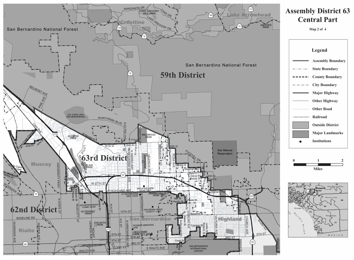
Assembly District 63Redlands Detail
Map 3 of 4
Riverside
San Diego
San Bernardino
M E X I C O
Orange
80
65
66
34
64
73
75
74
70
76
54 67
Imperial
Los Angeles
77
59
71
36
63
60
79
38
62
78
61
44
72
5743
5556
68
49
53
69
42
P
ac
if
ic
Oc
ea
n
MappedArea
Legend
Assembly Boundary
State Boundary
County Boundary
City Boundary
Major Highway
Other Highway
Other Road
Railroad
Outside District
Major Landmarks
Institutions
HERMOSA CEMETERY
HILLSIDECEMETERY
AGUA MESACEMETERY
LOMA LINDAUNIVERSITY
REDLANDSCOMMUNITY
HOSPITAL
SAN BERNARDINOVALLEY COLLEGE
LOMA LINDACOMMUNITY
HOSPITALLOMA LINDAUNIVERSITY MEDICAL
MONTECITOMEMORIAL PARK
PALM MEADOWSGC
UNIV OF REDLANDS
UCRIVERSIDE
VETERANSPARK
TERRACEHILLS PARK
JENNIE DAVISPARK
BOX SPRINGS
MOUNTAIN PARK
REIDPARK
HUNTERPARK
HIGHLANDPARK
Colton
Redlands
Riverside
San Bernardino
Loma Linda
San Bernardino County
Riverside County
Moreno Valley
GrandTerrace
Highgrove
Rialto
Rialto
Highland
I-10
Pigeon Pass Rd
W Main St
Hea
cock
St
E Main St
LakeVista Rd
Jaclyn Ave
Spring St
Cooley Ave
Lass
elle
St
Gould St
Cla
rk S
t
Kalmia Ave
Riv
ersi
deC
anal
Coulston St
Hardt St
California A
ve
Lake
Summ
it Dr
Orange S
t
SunnymeadRanch Pky
S R
ichardsonSt
La C
ross
e Ave
SanThomas St Rid
gem
ont D
r
DavidsonSt
Canal
St
El Granito StK
itchi
ng S
t
Santa Barbara St
Canyon
Ranch R
d
Electric
Ave
San
Ric
ardo
St
Grand Terrace Rd
Mount
Vernon Ave
BartonRd
Santa Ana River
Industrial Rd
Crest of the BadlandsPe
rris
Blv
d
SAN BERNARDINO INTERNATIONAL
AIRPORT
63rd District
64th District
65th District
65th District
BARTON RD
W RIALTO AVE
PIG
EO
N PA
SS
RD
S C
AD
EN
A D
R
CH
ICA
GO
AV
E
MA
IN S
T
3RD ST
CENTER ST
W MILL STE MILL ST
WAT
KIN
S D
R
CAJO
N ST
PE
RR
IS B
LVD
CH
UR
CH
ST
CA
LIFO
RN
IA S
T
REDLANDS BLVD
OLIVE ST
UNIVERSITY AVE
BEAUMONT AVE
KA
NS
AS
AV
E
E M ST
MANZANITA AVE
LUGONIA AVE
N R
AN
CH
O A
VE
CEN
TER ST
N C
AD
EN
A D
R
CYPRESS AVE
TIP
PE
CA
NO
E A
VE
SAN M
ATEO ST
STAT
E H
WY
38
COLTON AVE
SPRUCEST
E F ST FAIRWAY DR
MO
UN
TAIN
VIE
W A
VE
HIGHLAND AVE
AR
RO
WH
EA
D A
VE
AN
DE
RS
ON
ST
BROOKSIDE AVE
TE
NN
ES
SE
E S
T
COLUMBIAAVE
W BLAINE ST
E CITRUS AVE
LAKESIDE AVE
S R
IVE
RS
IDE
AVE
INLA
ND CEN
TER D
R
SLOVER AVE
LOCUST AVE
HE
AC
OC
K S
T
SIE
RR
A W
AY
W SUNSETDR
FERNAVE
PE
PP
ER
AV
E
S H
UN
TS
LN
14 TH ST
LA C
AD
EN
A D
R
SERPENTINE DR
CRESCENT AVE
SAN BERNADINO AVE
ALA
BA
MA
AV
E
UN
IVE
RS
ITY
ST
MT
VE
RN
ON
AV
E
S 3
RD
ST
HIG
H S
T
S E
ST
WAT
ER
MA
N A
VE
E WASHINGTON ST
ALLE
SA
ND
RO
RD
SANTIMOTEO CANYON
RD
TERR
ACIN
A BLVD
RE
CH
EC
AN
YON
RD
BO
XSPRINGS BLVD
W
AGUAMANSA RD
VALLEY BLVD
AU
TOP
LAZA
DR
62nd District
60
60
91
10
10
215
215
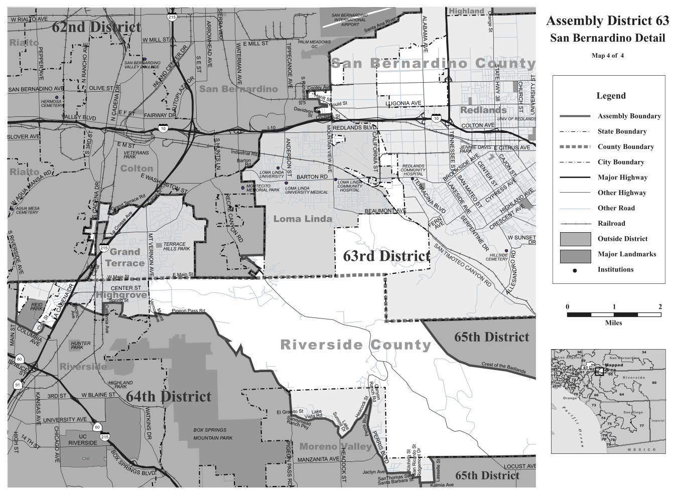
215 Assembly District 63San Bernardino Detail
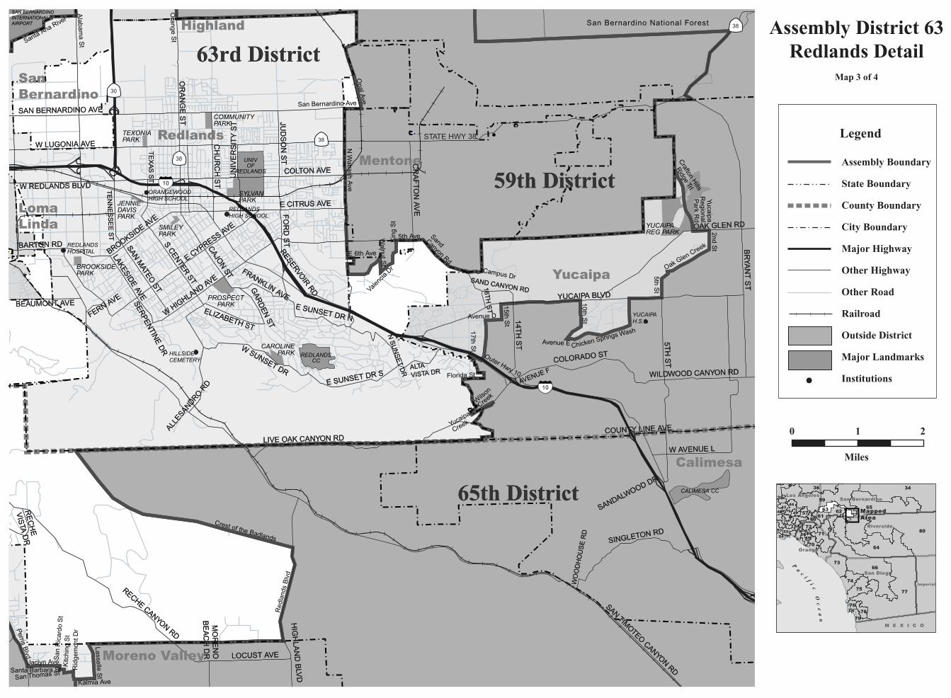
Map 4 of 4
0 1
Miles
2
R i v e r s i d e
San Diego
San Bernardino
M E X I C O
Orange
80
65
66
34
64
73
75
74
70
76
54 67
Imperial
Los Angeles
77
59
71
36
63
60
79
38
62
78
61
44
72
5743
5556
68
49
53
69
42
P
ac
if
ic
Oc
ea
n
MappedArea
Legend
Assembly Boundary
State Boundary
County Boundary
City Boundary
Major Highway
Other Highway
Other Road
Railroad
Outside District
Major Landmarks
Institutions
C A L I F O R N I A A S S E M B LY D I S T R I C T S
Assembly Redistricting Plan (SB 802), September 13, 2001
The Honorable Robert M. Hertzberg, SpeakerState CapitolRoom 219Sacramento, CA 95814
The California State Assembly Rules CommitteeThe Honorable Dennis Cardoza, ChairP.O. Box 942849Sacramento, CA 94249-0001
The California State Assembly Committee on Elections, Reapportionment, and Constitutional AmendmentsThe Honorable John Longville, ChairP.O. Box 942849Sacramento, CA 94249-0001
Produced at California State University NorthridgeDr. Jolene Koester, President
Eugene Turner, Project DirectorDepartment of Geography18111 Nordhoff St.Northridge, CA 91330
with
Rubyjane Domingo, Pat Jolley, Meredith Leonard
2001
About the Maps
These maps present specific informationabout the features comprising the borders of theAssembly Districts of California that were cre-ated after the 2000 Census. Each of the 80 dis-tricts are represented by one to ten maps withthe number depending on the size of the districtand the complexity of the features followed bythe boundary. In general, the boundaries followcounty lines, city limit lines, and roads, butoccasionally canals, streams, and small roadsare followed.
The Assembly boundary data were creat-ed in digital form from Census 2000 TIGERfiles for California by Pactech Incorporated ofPasadena, CA. The boundary files were releasedin two forms, as a file of district polygons andas a file of line segments used to create thepolygons. Where these line segments were iden-tified, those identifiers were used to label themap boundaries. In addition, place boundarieswere created from the TIGER files.
Other map information such as roads,railroads, coastlines, and landmarks wereobtained from Geographic Data Technologies.Dynamap 2000 files (v10.1). Government landownership information such as national forestboundaries was obtained from a governmentland ownership layer prepared by the CaliforniaTeale Data Center.
Maps were prepared from the digitalfiles using Arcmap 8.1 software fromEnvironmental Systems Research Incorporated.An Albers equal area projection was used forthe maps with a central meridian of 120 degreeswest longitude and standard parallels of 30 and40 degrees of latitude. Coordinates are based onNAD83.
Top Related