Waar zijn ze? Wat is hun geologische geschiedenis?rijnland.gea-geologie.nl/sites/default/files/0 De...
70
Waar zijn ze? Wat is hun geologische geschiedenis? Kan je die herkennen in het veld? door: Rob Hekkenberg, 2017-01-17 1
Transcript of Waar zijn ze? Wat is hun geologische geschiedenis?rijnland.gea-geologie.nl/sites/default/files/0 De...
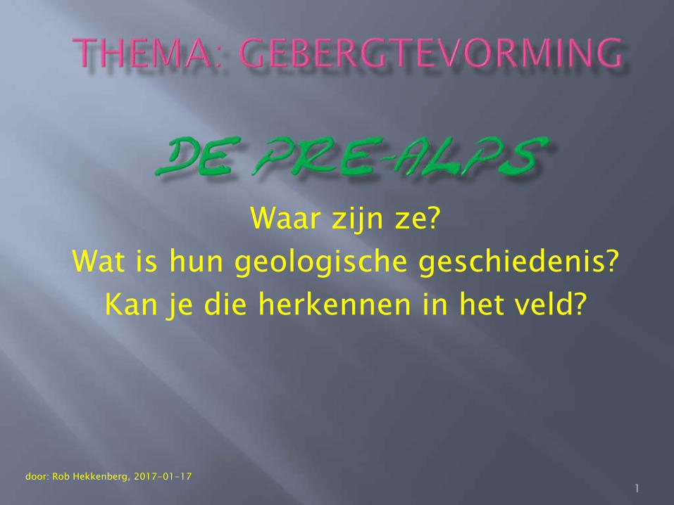
Waar zijn ze?
Wat is hun geologische geschiedenis?
Kan je die herkennen in het veld?
door: Rob Hekkenberg, 2017-01-17
1

Aan het eind van de presentatie staat een lijst van de literatuur en de figuren die gebruikt zijn voor deze presentatie. Deze presentatie mag niet commercieel gebruikt worden.
2

pre- Also found in: Medical, Acronyms, Wikipedia. Pre-pref. 1. a. Earlier; before; prior to: prehistoric. b. Preparatory; preliminary: premedical. c. In advance: prepay. 2. Anterior; in front of: preaxial.
3
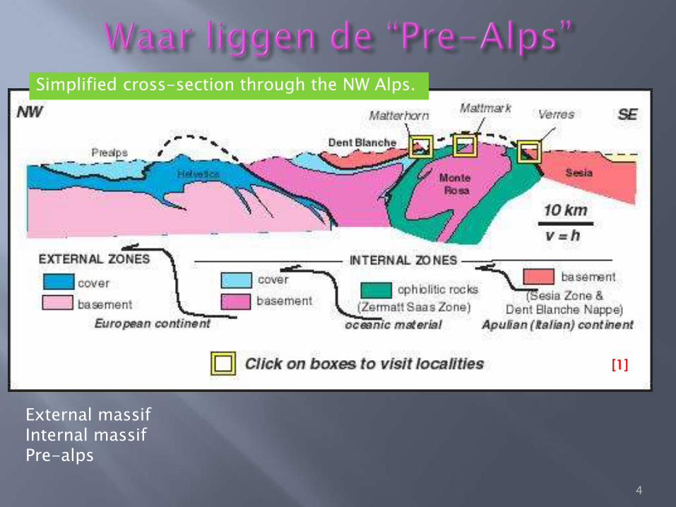
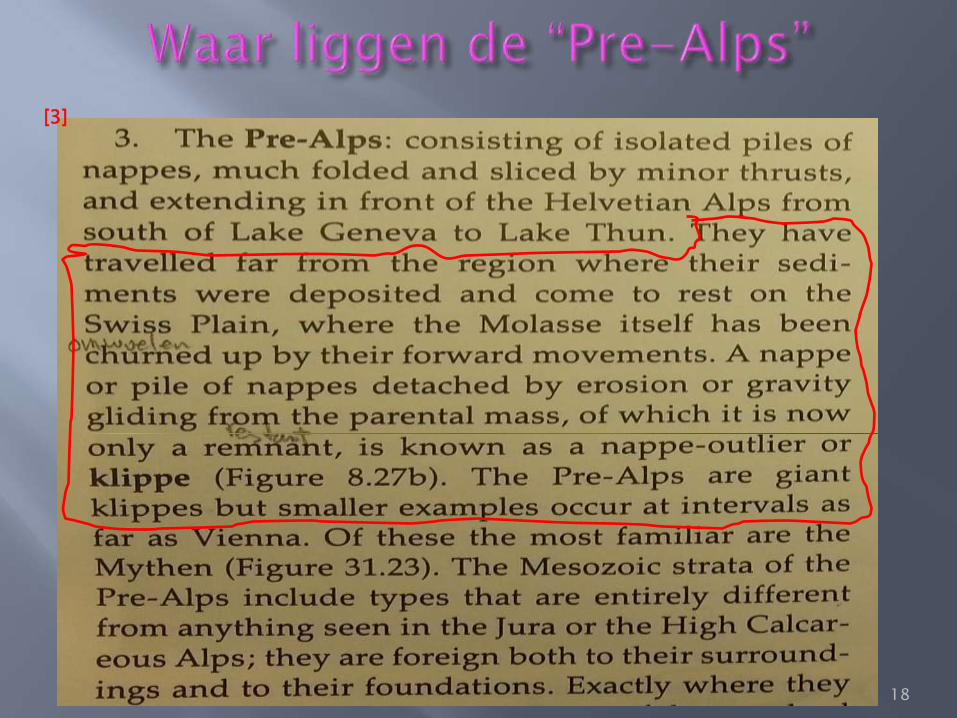
Simplified cross-section through the NW Alps.
External massif Internal massif Pre-alps
[1]
4
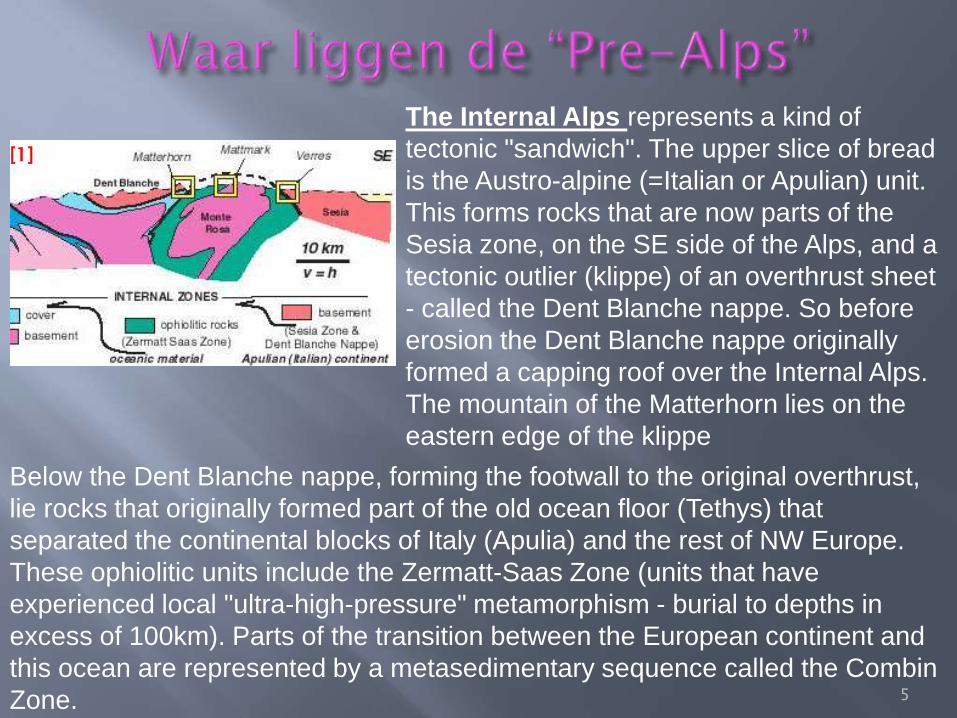
The Internal Alps represents a kind of
tectonic "sandwich". The upper slice of bread
is the Austro-alpine (=Italian or Apulian) unit.
This forms rocks that are now parts of the
Sesia zone, on the SE side of the Alps, and a
tectonic outlier (klippe) of an overthrust sheet
- called the Dent Blanche nappe. So before
erosion the Dent Blanche nappe originally
formed a capping roof over the Internal Alps.
The mountain of the Matterhorn lies on the
eastern edge of the klippe
Below the Dent Blanche nappe, forming the footwall to the original overthrust,
lie rocks that originally formed part of the old ocean floor (Tethys) that
separated the continental blocks of Italy (Apulia) and the rest of NW Europe.
These ophiolitic units include the Zermatt-Saas Zone (units that have
experienced local "ultra-high-pressure" metamorphism - burial to depths in
excess of 100km). Parts of the transition between the European continent and
this ocean are represented by a metasedimentary sequence called the Combin
Zone.
[1]
5
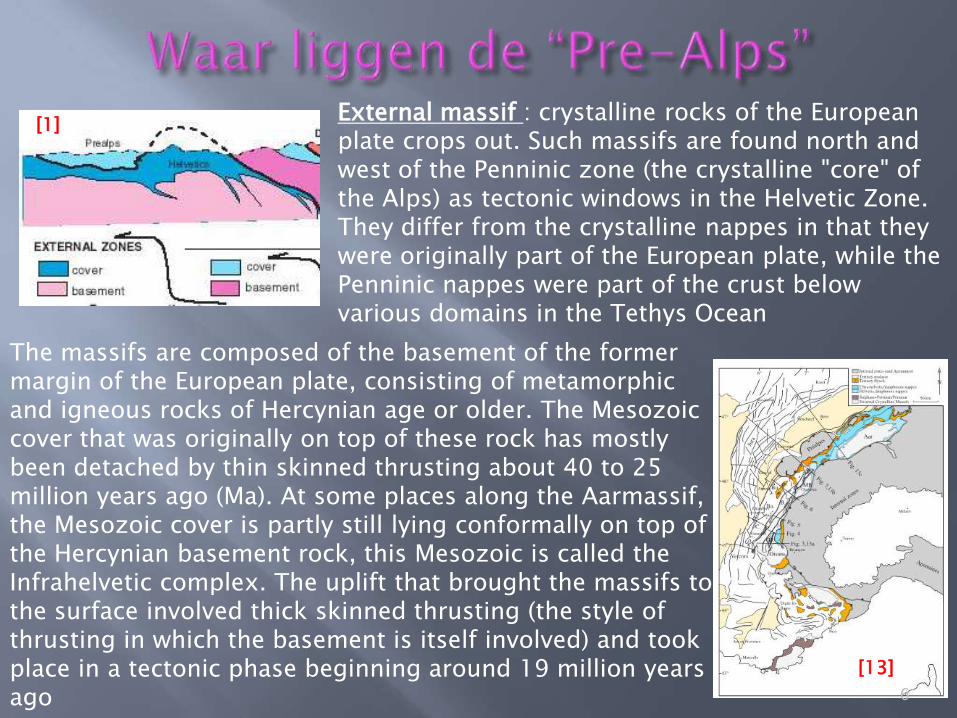
External massif : crystalline rocks of the European plate crops out. Such massifs are found north and west of the Penninic zone (the crystalline "core" of the Alps) as tectonic windows in the Helvetic Zone. They differ from the crystalline nappes in that they were originally part of the European plate, while the Penninic nappes were part of the crust below various domains in the Tethys Ocean
The massifs are composed of the basement of the former margin of the European plate, consisting of metamorphic and igneous rocks of Hercynian age or older. The Mesozoic cover that was originally on top of these rock has mostly been detached by thin skinned thrusting about 40 to 25 million years ago (Ma). At some places along the Aarmassif, the Mesozoic cover is partly still lying conformally on top of the Hercynian basement rock, this Mesozoic is called the Infrahelvetic complex. The uplift that brought the massifs to the surface involved thick skinned thrusting (the style of thrusting in which the basement is itself involved) and took place in a tectonic phase beginning around 19 million years ago
[13]
[1]
6
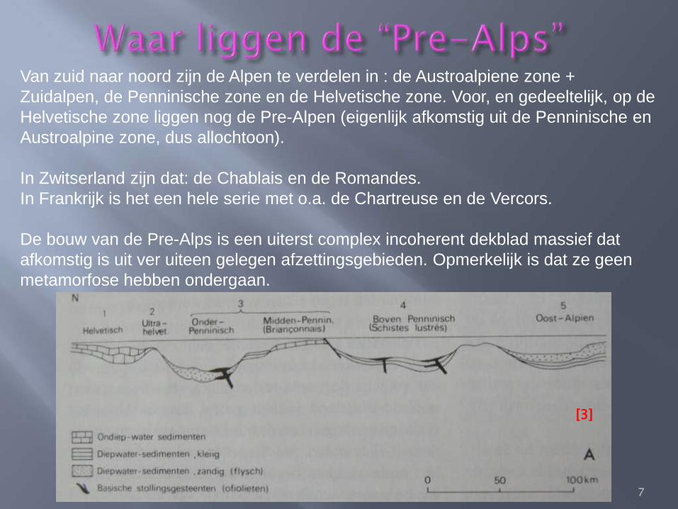
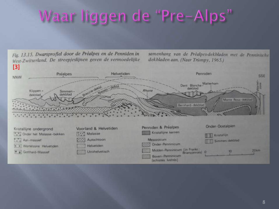
Van zuid naar noord zijn de Alpen te verdelen in : de Austroalpiene zone +
Zuidalpen, de Penninische zone en de Helvetische zone. Voor, en gedeeltelijk, op de
Helvetische zone liggen nog de Pre-Alpen (eigenlijk afkomstig uit de Penninische en
Austroalpine zone, dus allochtoon).
In Zwitserland zijn dat: de Chablais en de Romandes.
In Frankrijk is het een hele serie met o.a. de Chartreuse en de Vercors.
De bouw van de Pre-Alps is een uiterst complex incoherent dekblad massief dat
afkomstig is uit ver uiteen gelegen afzettingsgebieden. Opmerkelijk is dat ze geen
metamorfose hebben ondergaan.
[3]
7
[3]
8
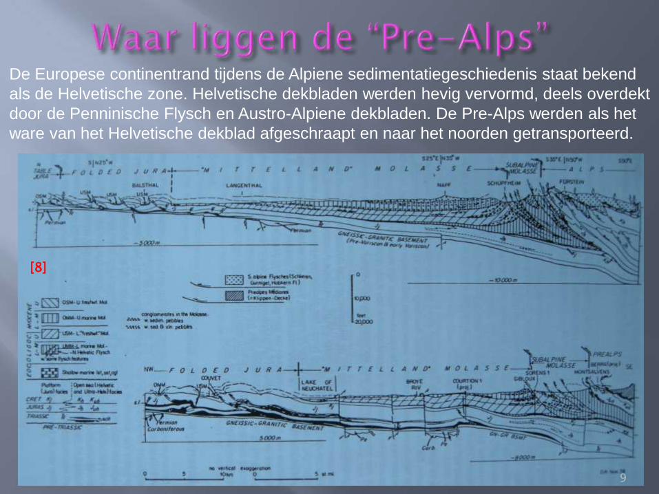
De Europese continentrand tijdens de Alpiene sedimentatiegeschiedenis staat bekend
als de Helvetische zone. Helvetische dekbladen werden hevig vervormd, deels overdekt
door de Penninische Flysch en Austro-Alpiene dekbladen. De Pre-Alps werden als het
ware van het Helvetische dekblad afgeschraapt en naar het noorden getransporteerd.
[8]
9
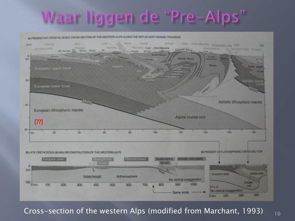
Cross-section of the western Alps (modified from Marchant, 1993)
[??]
10
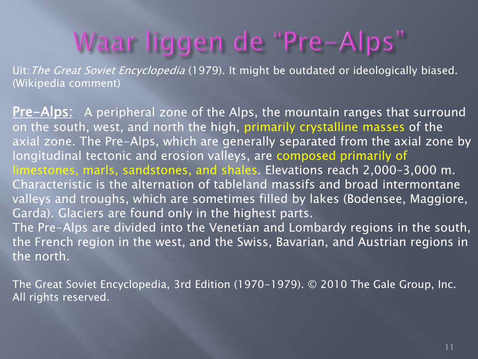
Uit:The Great Soviet Encyclopedia (1979). It might be outdated or ideologically biased. (Wikipedia comment)
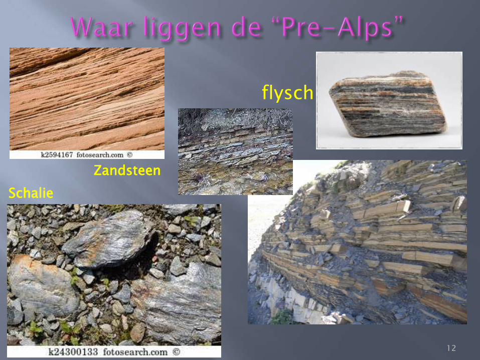
Pre-Alps: A peripheral zone of the Alps, the mountain ranges that surround on the south, west, and north the high, primarily crystalline masses of the axial zone. The Pre-Alps, which are generally separated from the axial zone by longitudinal tectonic and erosion valleys, are composed primarily of limestones, marls, sandstones, and shales. Elevations reach 2,000–3,000 m. Characteristic is the alternation of tableland massifs and broad intermontane valleys and troughs, which are sometimes filled by lakes (Bodensee, Maggiore, Garda). Glaciers are found only in the highest parts. The Pre-Alps are divided into the Venetian and Lombardy regions in the south, the French region in the west, and the Swiss, Bavarian, and Austrian regions in the north. The Great Soviet Encyclopedia, 3rd Edition (1970-1979). © 2010 The Gale Group, Inc. All rights reserved.
11
12
flysch
Schalie
Zandsteen
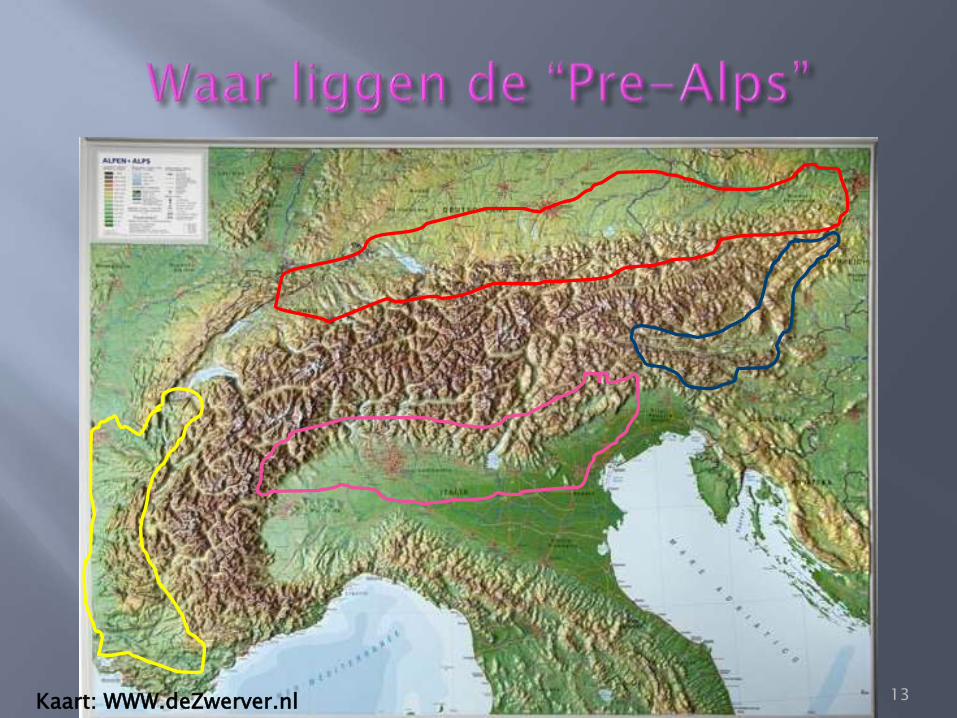
Kaart: WWW.deZwerver.nl 13
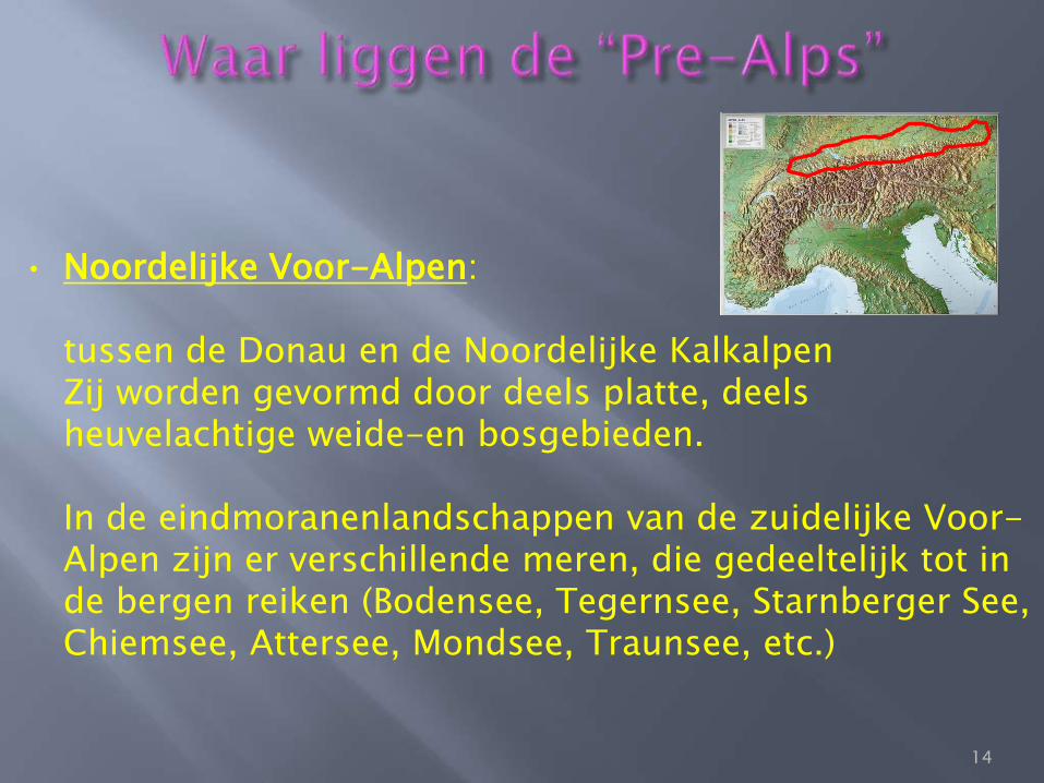
• Noordelijke Voor-Alpen: tussen de Donau en de Noordelijke Kalkalpen Zij worden gevormd door deels platte, deels heuvelachtige weide-en bosgebieden.
In de eindmoranenlandschappen van de zuidelijke Voor-
Alpen zijn er verschillende meren, die gedeeltelijk tot in de bergen reiken (Bodensee, Tegernsee, Starnberger See, Chiemsee, Attersee, Mondsee, Traunsee, etc.)
14
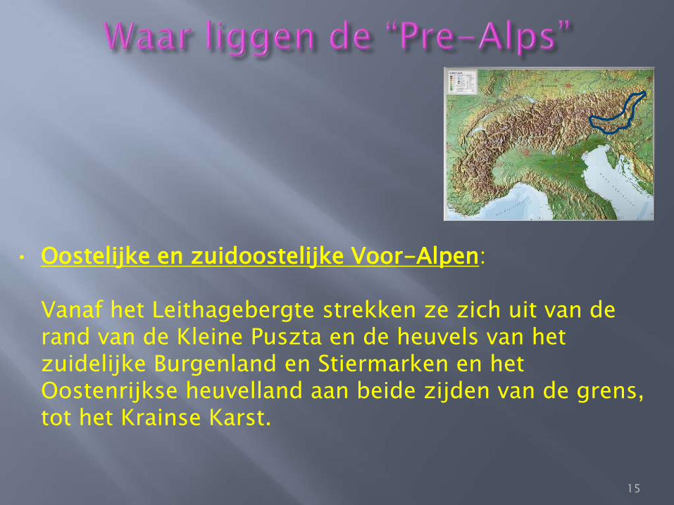
• Oostelijke en zuidoostelijke Voor-Alpen: Vanaf het Leithagebergte strekken ze zich uit van de rand van de Kleine Puszta en de heuvels van het zuidelijke Burgenland en Stiermarken en het Oostenrijkse heuvelland aan beide zijden van de grens, tot het Krainse Karst.
15
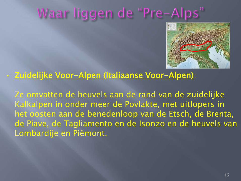
• Zuidelijke Voor-Alpen (Italiaanse Voor-Alpen): Ze omvatten de heuvels aan de rand van de zuidelijke Kalkalpen in onder meer de Povlakte, met uitlopers in het oosten aan de benedenloop van de Etsch, de Brenta, de Piave, de Tagliamento en de Isonzo en de heuvels van Lombardije en Piëmont.
16
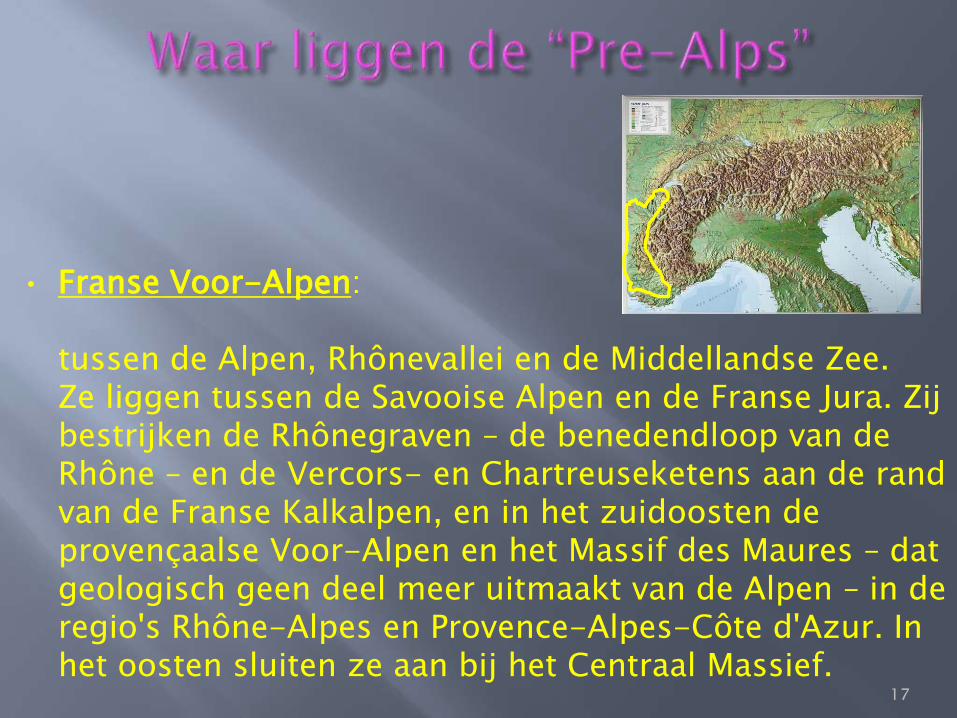
• Franse Voor-Alpen: tussen de Alpen, Rhônevallei en de Middellandse Zee. Ze liggen tussen de Savooise Alpen en de Franse Jura. Zij bestrijken de Rhônegraven – de benedendloop van de Rhône – en de Vercors- en Chartreuseketens aan de rand van de Franse Kalkalpen, en in het zuidoosten de provençaalse Voor-Alpen en het Massif des Maures – dat geologisch geen deel meer uitmaakt van de Alpen – in de regio's Rhône-Alpes en Provence-Alpes-Côte d'Azur. In het oosten sluiten ze aan bij het Centraal Massief.
17
18
[3]
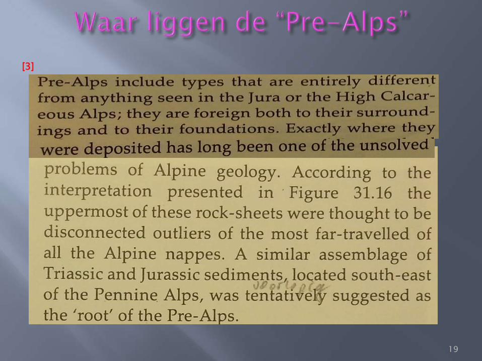
19
[3]
[9]
20
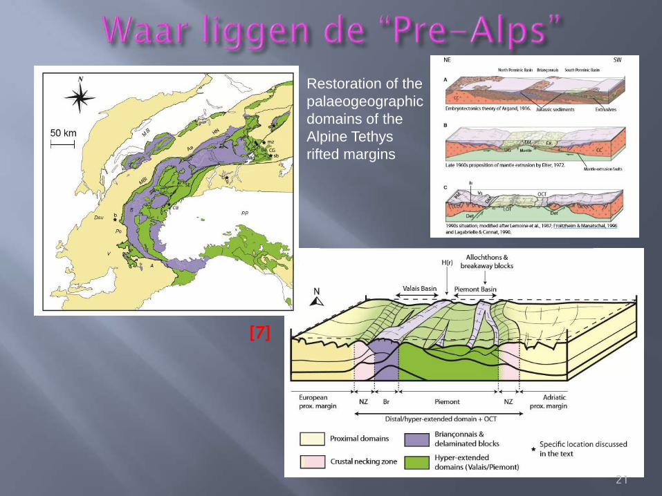
Restoration of the
palaeogeographic
domains of the
Alpine Tethys
rifted margins
[7]
21
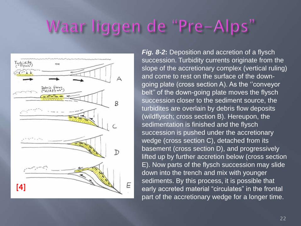
Fig. 8-2: Deposition and accretion of a flysch
succession. Turbidity currents originate from the
slope of the accretionary complex (vertical ruling)
and come to rest on the surface of the down-
going plate (cross section A). As the ‘’conveyor
belt’’ of the down-going plate moves the flysch
succession closer to the sediment source, the
turbidites are overlain by debris flow deposits
(wildflysch; cross section B). Hereupon, the
sedimentation is finished and the flysch
succession is pushed under the accretionary
wedge (cross section C), detached from its
basement (cross section D), and progressively
lifted up by further accretion below (cross section
E). Now parts of the flysch succession may slide
down into the trench and mix with younger
sediments. By this process, it is possible that
early accreted material “circulates” in the frontal
part of the accretionary wedge for a longer time.
[4]
22
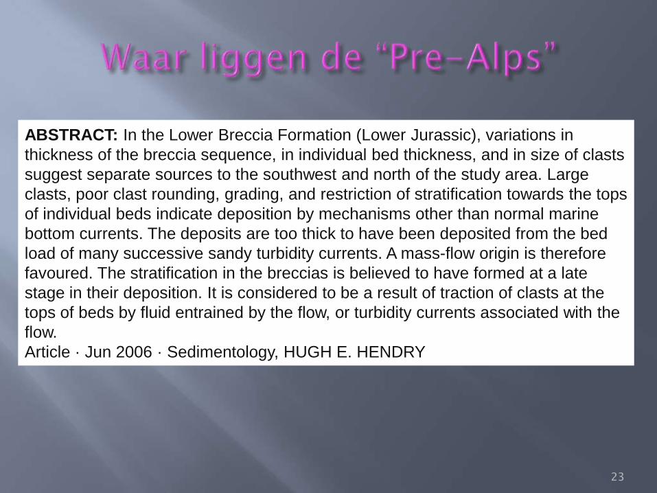
ABSTRACT: In the Lower Breccia Formation (Lower Jurassic), variations in
thickness of the breccia sequence, in individual bed thickness, and in size of clasts
suggest separate sources to the southwest and north of the study area. Large
clasts, poor clast rounding, grading, and restriction of stratification towards the tops
of individual beds indicate deposition by mechanisms other than normal marine
bottom currents. The deposits are too thick to have been deposited from the bed
load of many successive sandy turbidity currents. A mass-flow origin is therefore
favoured. The stratification in the breccias is believed to have formed at a late
stage in their deposition. It is considered to be a result of traction of clasts at the
tops of beds by fluid entrained by the flow, or turbidity currents associated with the
flow.
Article · Jun 2006 · Sedimentology, HUGH E. HENDRY
23
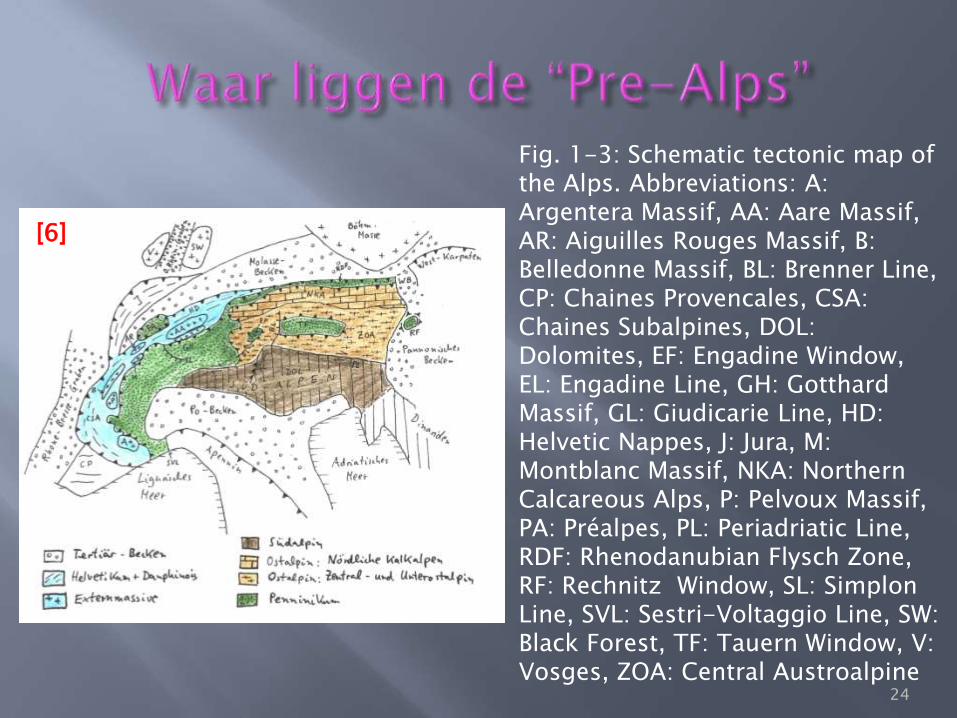
Fig. 1-3: Schematic tectonic map of the Alps. Abbreviations: A: Argentera Massif, AA: Aare Massif, AR: Aiguilles Rouges Massif, B: Belledonne Massif, BL: Brenner Line, CP: Chaines Provencales, CSA: Chaines Subalpines, DOL: Dolomites, EF: Engadine Window, EL: Engadine Line, GH: Gotthard Massif, GL: Giudicarie Line, HD: Helvetic Nappes, J: Jura, M: Montblanc Massif, NKA: Northern Calcareous Alps, P: Pelvoux Massif, PA: Préalpes, PL: Periadriatic Line, RDF: Rhenodanubian Flysch Zone, RF: Rechnitz Window, SL: Simplon Line, SVL: Sestri-Voltaggio Line, SW: Black Forest, TF: Tauern Window, V: Vosges, ZOA: Central Austroalpine
[6]
24
25
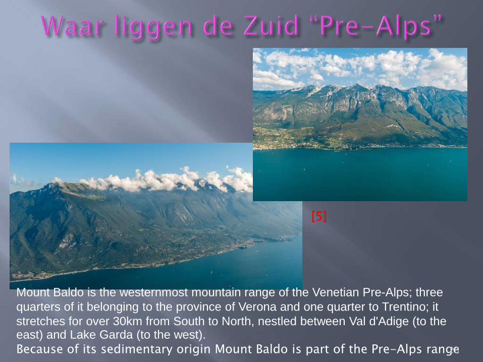
Mount Baldo is the westernmost mountain range of the Venetian Pre-Alps; three
quarters of it belonging to the province of Verona and one quarter to Trentino; it
stretches for over 30km from South to North, nestled between Val d'Adige (to the east) and Lake Garda (to the west). Because of its sedimentary origin Mount Baldo is part of the Pre-Alps range
[5]
26
In the southeastern part of the Préalpes, the Breccia Nappe rests on the Préalpes
Médianes (Rigides) Nappe. It comprises Upper Triassic (dolomite, slate, coquinitic
limestone), Liassic limestone and slate, a lower succession of sedimentary breccias
with components of Triassic dolomite and Liassic limestone (Upper Liassic and
Dogger?), slate with radiolarite layers (Lower Malm), an upper brecia succession
(Upper Malm?), cherty limestones (Lower Cretaceous), slate with quartzite layers
(Aptian-Albian), Couches Rouges, i.e. pelagic marls (Late Cretaceous to Eocene),
and “wildflysch”.
The Jurassic breccias were shed from fault scarps located to the Northwest. These
may have been related to normal faults at the continental margin between the
Briançonnais (NW) and the Piemont-Liguria Ocean (SE).
27
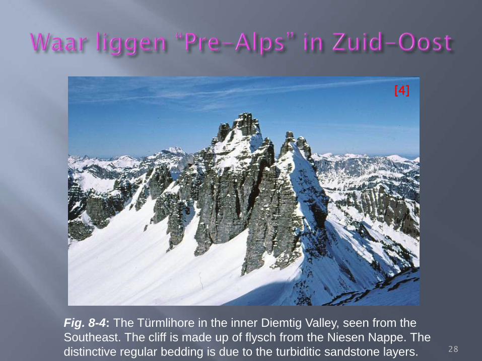
Fig. 8-4: The Türmlihore in the inner Diemtig Valley, seen from the
Southeast. The cliff is made up of flysch from the Niesen Nappe. The
distinctive regular bedding is due to the turbiditic sandstone layers.
[4]
28
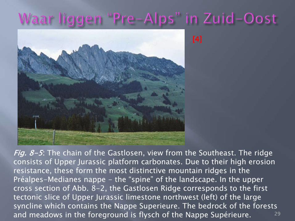
Fig. 8-5: The chain of the Gastlosen, view from the Southeast. The ridge consists of Upper Jurassic platform carbonates. Due to their high erosion resistance, these form the most distinctive mountain ridges in the Préalpes-Medianes nappe - the “spine” of the landscape. In the upper cross section of Abb. 8-2, the Gastlosen Ridge corresponds to the first tectonic slice of Upper Jurassic limestone northwest (left) of the large syncline which contains the Nappe Superieure. The bedrock of the forests and meadows in the foreground is flysch of the Nappe Supérieure.
[4]
29
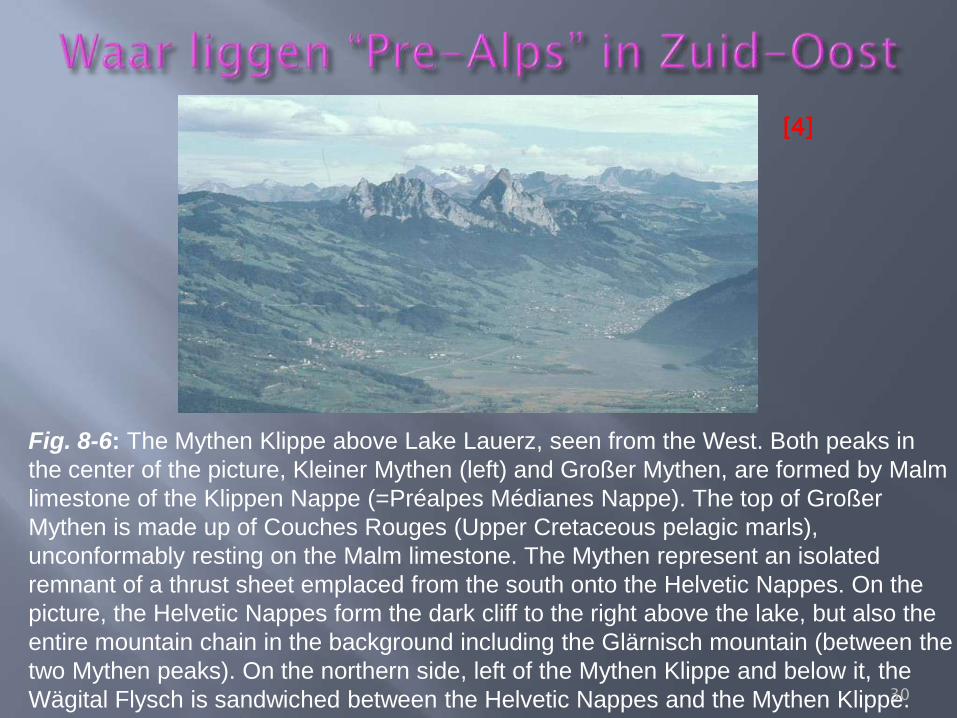
Fig. 8-6: The Mythen Klippe above Lake Lauerz, seen from the West. Both peaks in
the center of the picture, Kleiner Mythen (left) and Großer Mythen, are formed by Malm
limestone of the Klippen Nappe (=Préalpes Médianes Nappe). The top of Großer
Mythen is made up of Couches Rouges (Upper Cretaceous pelagic marls),
unconformably resting on the Malm limestone. The Mythen represent an isolated
remnant of a thrust sheet emplaced from the south onto the Helvetic Nappes. On the
picture, the Helvetic Nappes form the dark cliff to the right above the lake, but also the
entire mountain chain in the background including the Glärnisch mountain (between the
two Mythen peaks). On the northern side, left of the Mythen Klippe and below it, the
Wägital Flysch is sandwiched between the Helvetic Nappes and the Mythen Klippe.
[4]
30
31
32
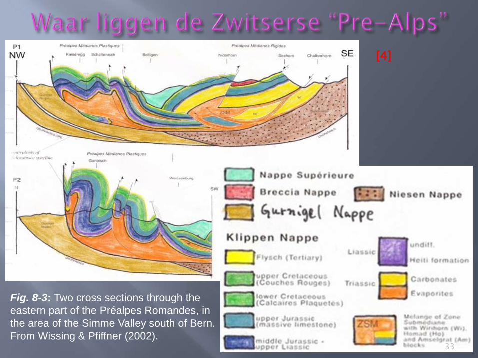
Fig. 8-3: Two cross sections through the
eastern part of the Préalpes Romandes, in
the area of the Simme Valley south of Bern.
From Wissing & Pfiffner (2002).
[4]
33
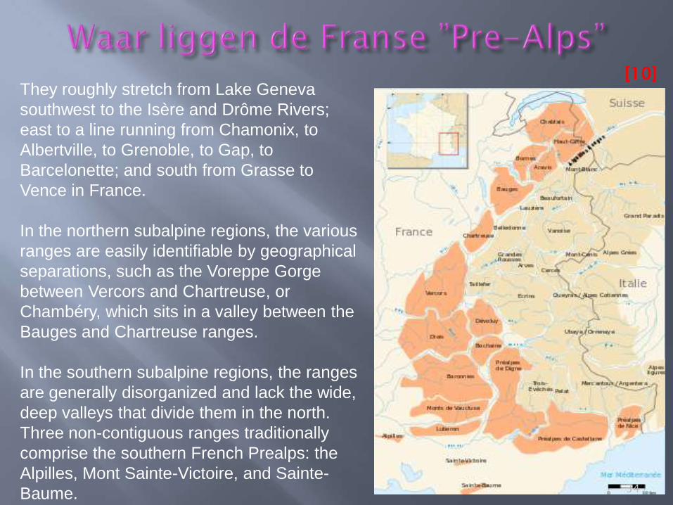
They roughly stretch from Lake Geneva
southwest to the Isère and Drôme Rivers;
east to a line running from Chamonix, to
Albertville, to Grenoble, to Gap, to
Barcelonette; and south from Grasse to
Vence in France.
In the northern subalpine regions, the various
ranges are easily identifiable by geographical
separations, such as the Voreppe Gorge
between Vercors and Chartreuse, or
Chambéry, which sits in a valley between the
Bauges and Chartreuse ranges.
In the southern subalpine regions, the ranges
are generally disorganized and lack the wide,
deep valleys that divide them in the north.
Three non-contiguous ranges traditionally
comprise the southern French Prealps: the
Alpilles, Mont Sainte-Victoire, and Sainte-
Baume.
[10]
34
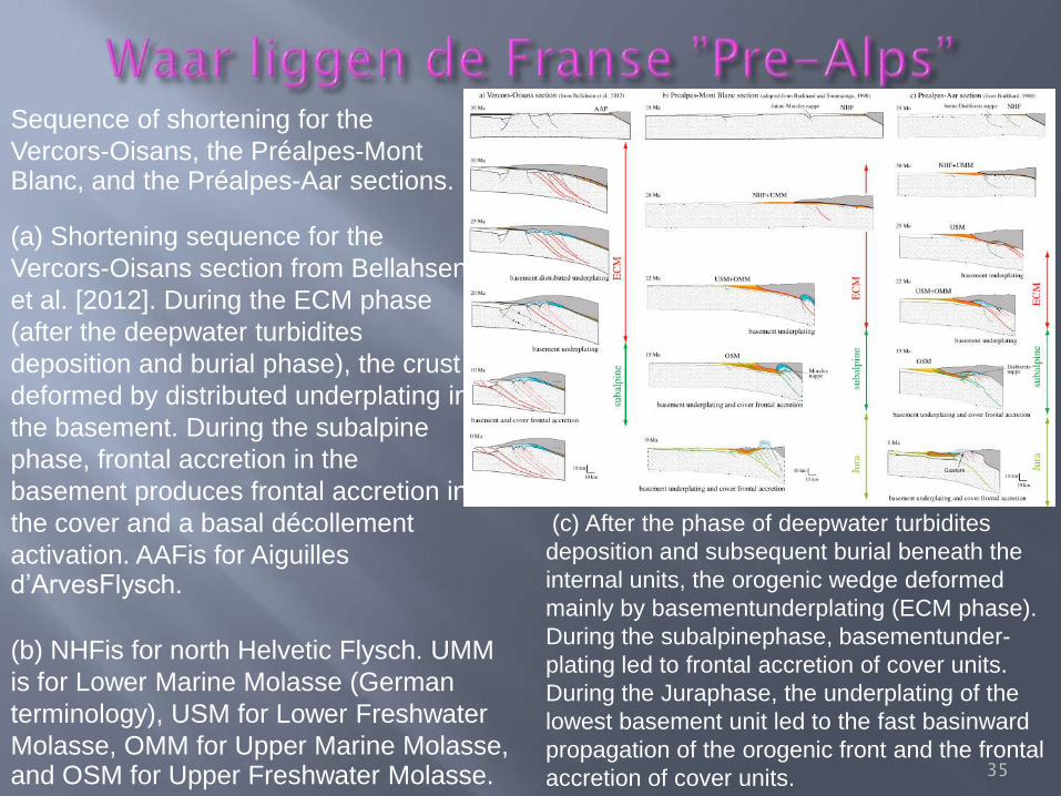
(c) After the phase of deepwater turbidites
deposition and subsequent burial beneath the
internal units, the orogenic wedge deformed
mainly by basementunderplating (ECM phase).
During the subalpinephase, basementunder-
plating led to frontal accretion of cover units.
During the Juraphase, the underplating of the
lowest basement unit led to the fast basinward
propagation of the orogenic front and the frontal
accretion of cover units. 35
(a) Shortening sequence for the
Vercors-Oisans section from Bellahsen
et al. [2012]. During the ECM phase
(after the deepwater turbidites
deposition and burial phase), the crust
deformed by distributed underplating in
the basement. During the subalpine
phase, frontal accretion in the
basement produces frontal accretion in
the cover and a basal décollement
activation. AAFis for Aiguilles d’ArvesFlysch.
Sequence of shortening for the
Vercors-Oisans, the Préalpes-Mont Blanc, and the Préalpes-Aar sections.
(b) NHFis for north Helvetic Flysch. UMM
is for Lower Marine Molasse (German
terminology), USM for Lower Freshwater
Molasse, OMM for Upper Marine Molasse, and OSM for Upper Freshwater Molasse.
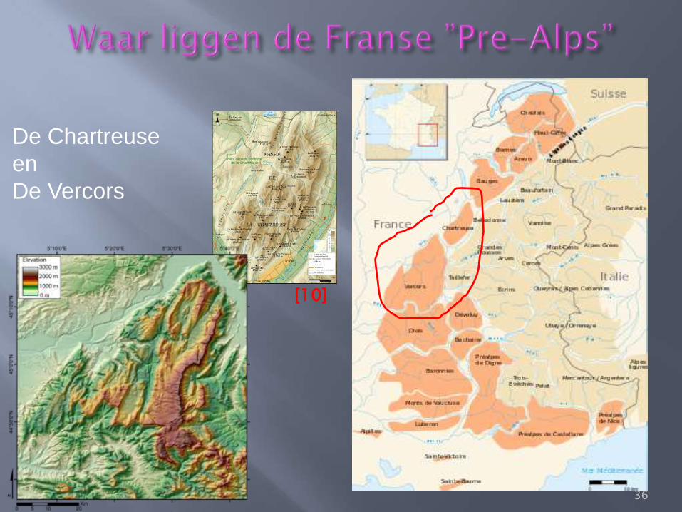
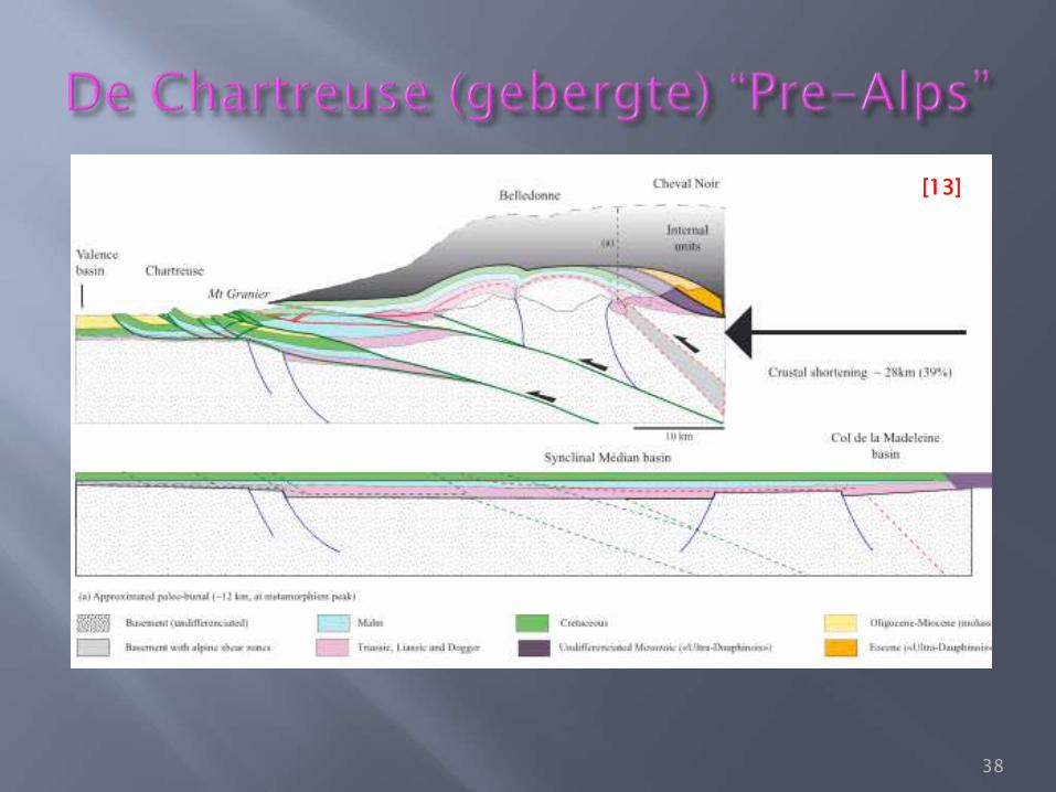
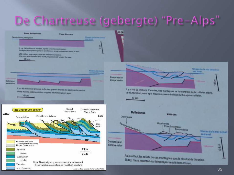
De Chartreuse
en
De Vercors
[10]
36
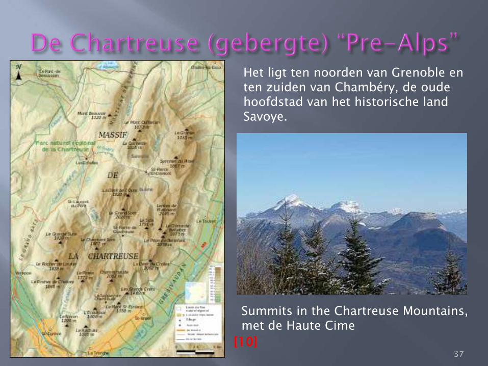
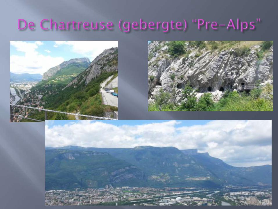
Het ligt ten noorden van Grenoble en ten zuiden van Chambéry, de oude hoofdstad van het historische land Savoye.
Summits in the Chartreuse Mountains, met de Haute Cime [10]
37
[13]
38
39
40
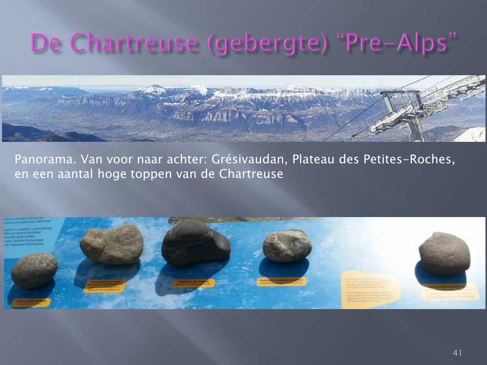
Panorama. Van voor naar achter: Grésivaudan, Plateau des Petites-Roches, en een aantal hoge toppen van de Chartreuse
41
42
43
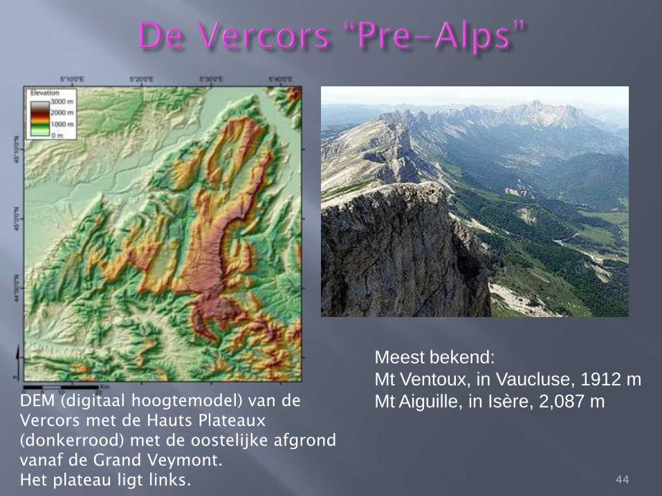
DEM (digitaal hoogtemodel) van de Vercors met de Hauts Plateaux (donkerrood) met de oostelijke afgrond vanaf de Grand Veymont. Het plateau ligt links.
Meest bekend:
Mt Ventoux, in Vaucluse, 1912 m
Mt Aiguille, in Isère, 2,087 m
44
The name Massif du Vercors is derived from the name of a local tribe
who lived in the area at the time of the Roman conquest of Gaul, who
were known as the Vertamocorii (also spelled Vertamocori,
Vertacomicorii, or Vertacomocorii), meaning excellent troops or troops of
the summit. Modern inhabitants are referred to as Vertacomiriens.
Prior to the 1900s, the name Vercors referred to the upper valleys of the
Vernaison near the township of La Chapelle-en-Vercors. At the beginning
of the 20th century, Henri Ferrand explored the massif, taking numerous
photographs, publishing books, and describing the geology of the
mountains. Ferrand was the first to use the term Vercors in its
contemporary sense. The geographers Raoul Blanchard and Jules
Blache, popularised the term in the late 1920s and early 1930s. By the
1950s, the term was ubiquitous.
45
The constituent rocks of the Vercors were formed by sedimentation about
165 million years ago, in the middle Jurassic period, at the bottom of the
Piemont-Liguria Ocean. The deposition of animal material formed limestone,
with detritus rocks, formed primarily from the erosion of marl from the
Variscan orogeny formed the massif in a period marked by changing climactic
conditions and ocean depth. Then, about 130 million years ago a rise in
temperatures combined with shallow waters led to the development of coral
reefs. These were the origin of the urgonian limestone which forms the upper
part of the massif, more prominently in the northern half.
In the Paleogene era (66-23 mj), the Tethys ocean closed up and at the start
of the Miocene (23-5 mj) the raising of the alps resulted in a nappe (thrust
shift) to the west and rocks of sedimentary origin were raised 2,000 metres
above the current location of the Massif des Écrins. The folding of these
rocks resulted in the Vercors having local synclines and anticlines
successively and, due to the hardness of the rock, there are faults.
Once formed, the massif underwent severe erosion, which accentuated the
relief.
46
[12]
47
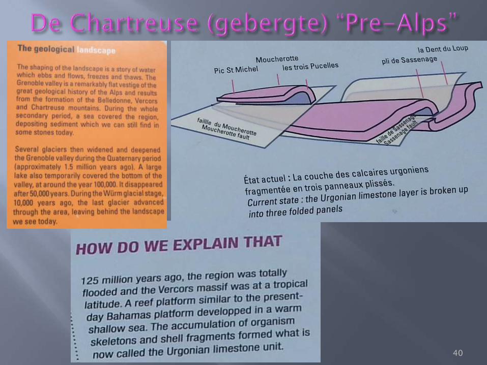
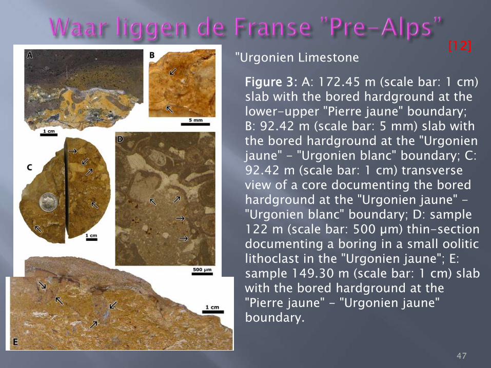
Figure 3: A: 172.45 m (scale bar: 1 cm) slab with the bored hardground at the lower-upper "Pierre jaune" boundary; B: 92.42 m (scale bar: 5 mm) slab with the bored hardground at the "Urgonien jaune" - "Urgonien blanc" boundary; C: 92.42 m (scale bar: 1 cm) transverse view of a core documenting the bored hardground at the "Urgonien jaune" - "Urgonien blanc" boundary; D: sample 122 m (scale bar: 500 µm) thin-section documenting a boring in a small oolitic lithoclast in the "Urgonien jaune"; E: sample 149.30 m (scale bar: 1 cm) slab with the bored hardground at the "Pierre jaune" - "Urgonien jaune" boundary.
"Urgonien Limestone
[13]
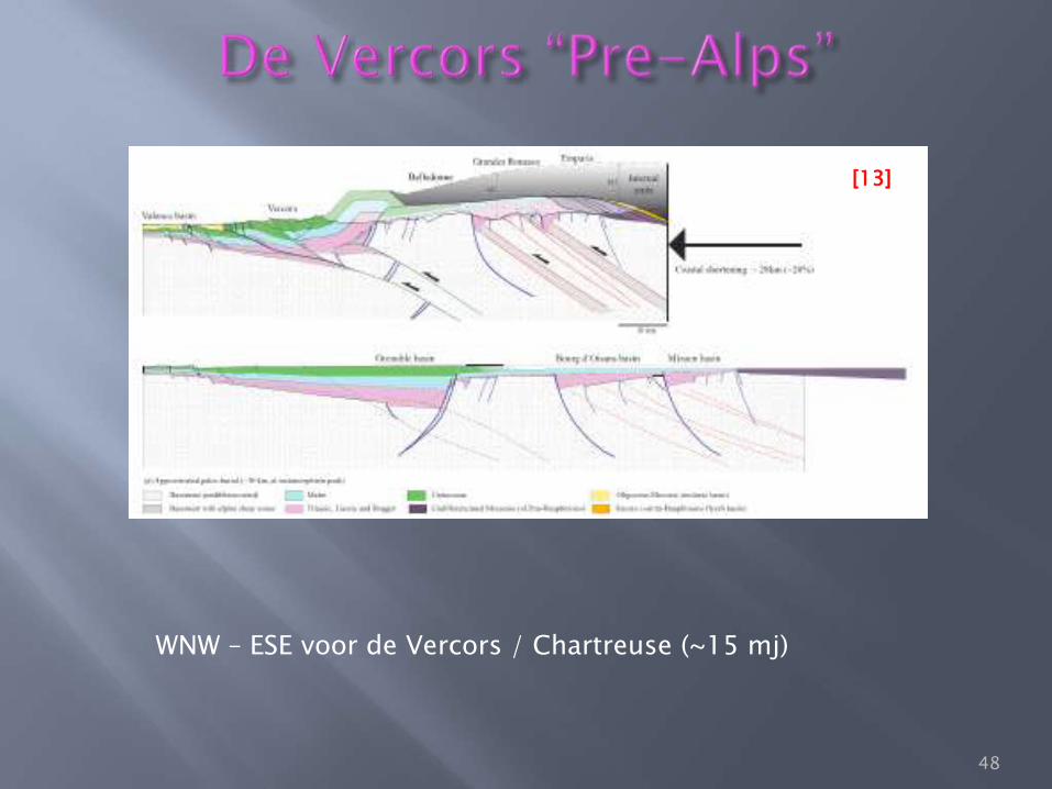
WNW – ESE voor de Vercors / Chartreuse (~15 mj)
48
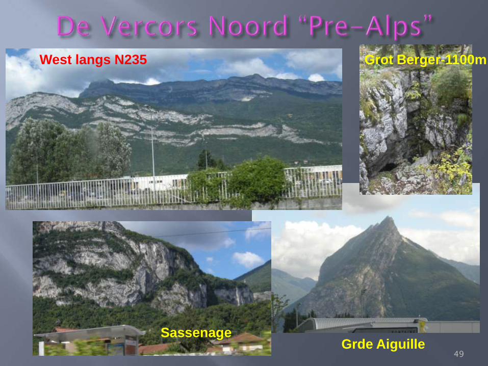
Grot Berger-1100m
Grde Aiguille
West langs N235
Sassenage
49
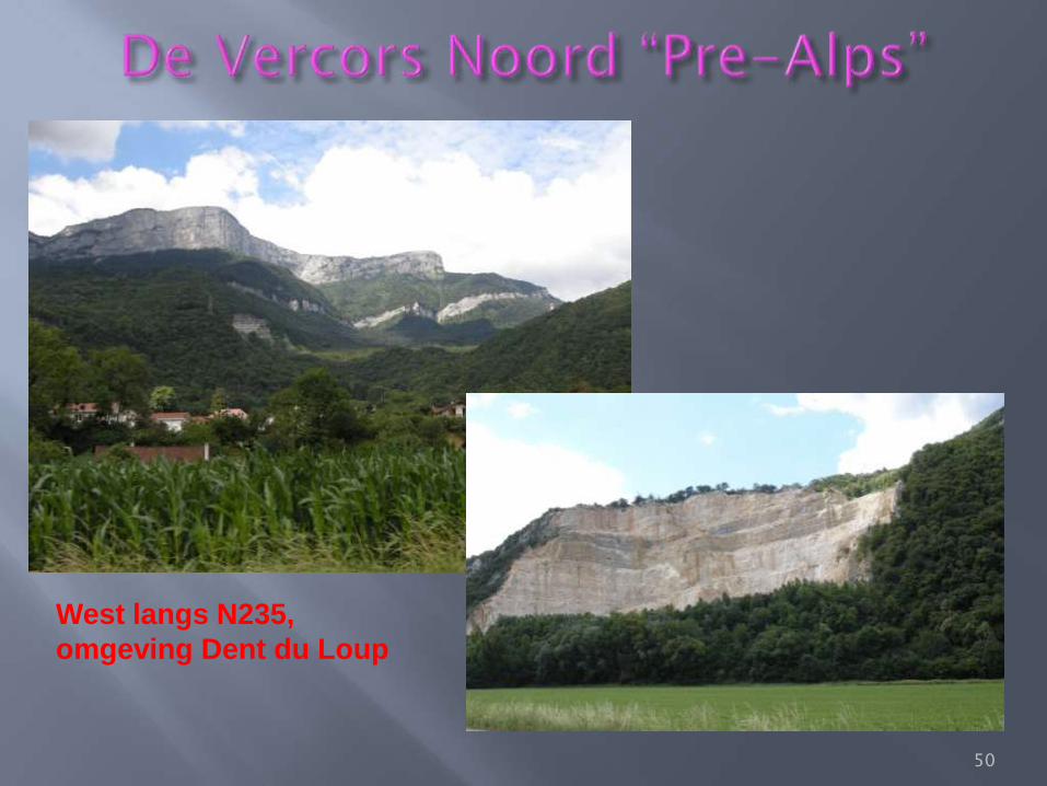
West langs N235,
omgeving Dent du Loup
50
51
52
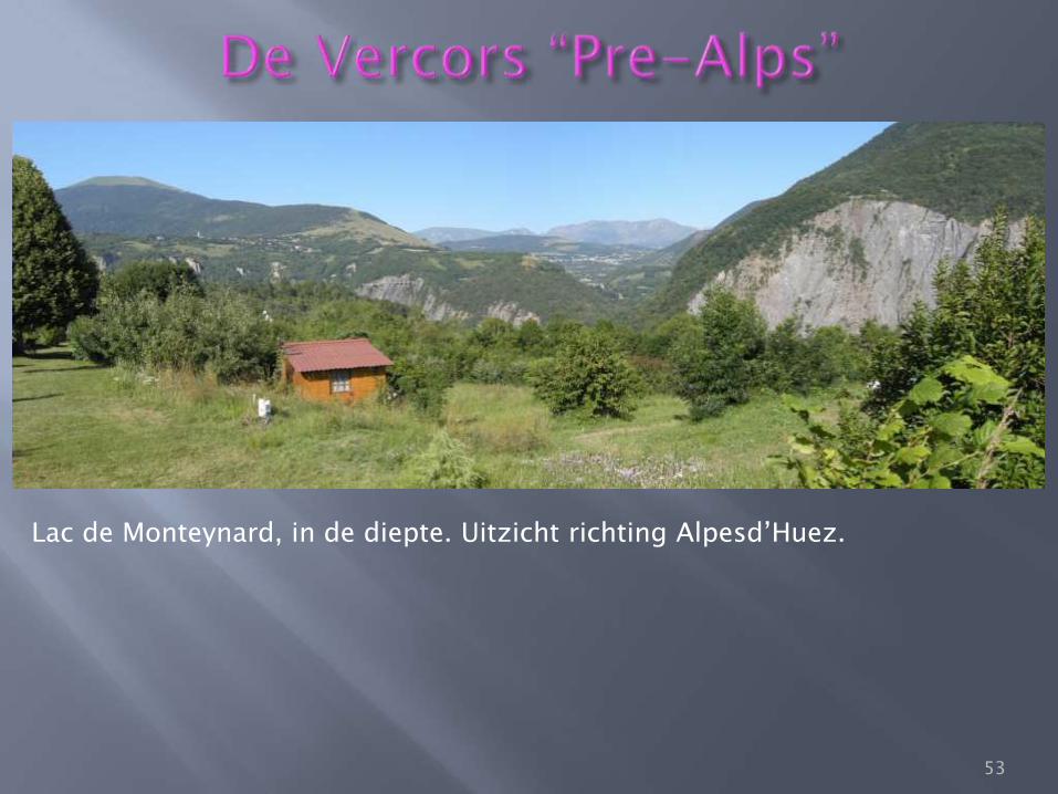
Lac de Monteynard, in de diepte. Uitzicht richting Alpesd’Huez.
53
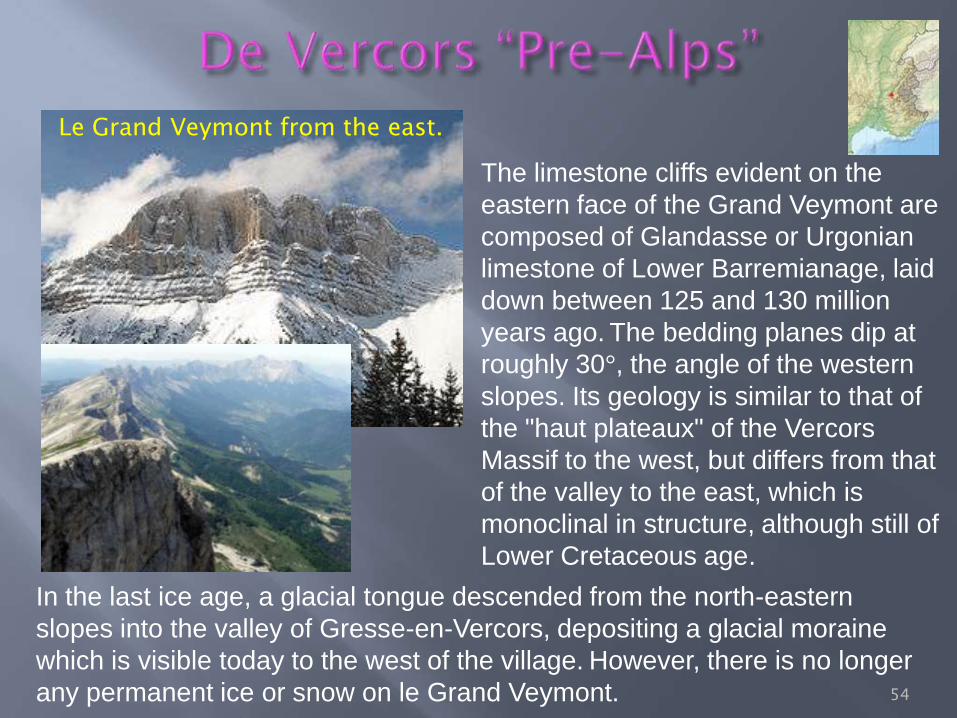
The limestone cliffs evident on the
eastern face of the Grand Veymont are
composed of Glandasse or Urgonian
limestone of Lower Barremianage, laid
down between 125 and 130 million
years ago. The bedding planes dip at
roughly 30°, the angle of the western
slopes. Its geology is similar to that of
the "haut plateaux" of the Vercors
Massif to the west, but differs from that
of the valley to the east, which is
monoclinal in structure, although still of
Lower Cretaceous age.
In the last ice age, a glacial tongue descended from the north-eastern
slopes into the valley of Gresse-en-Vercors, depositing a glacial moraine
which is visible today to the west of the village. However, there is no longer
any permanent ice or snow on le Grand Veymont.
Le Grand Veymont from the east.
54
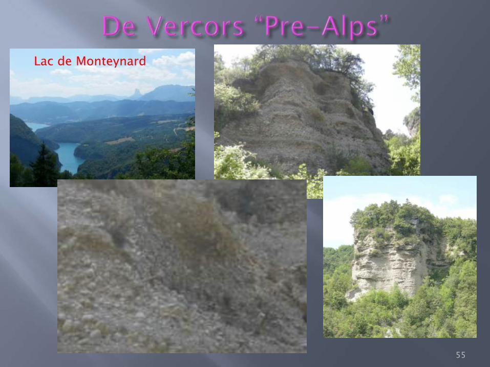
Lac de Monteynard
55
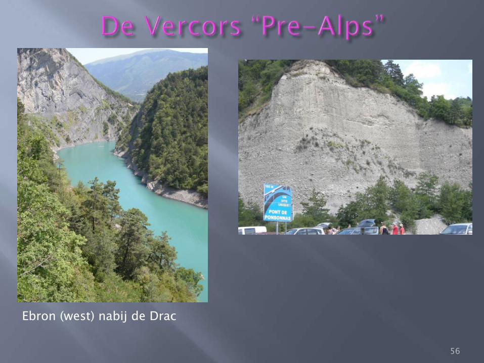
Ebron (west) nabij de Drac
56
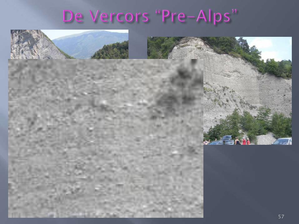
Ebron (west) nabij de Drac
57
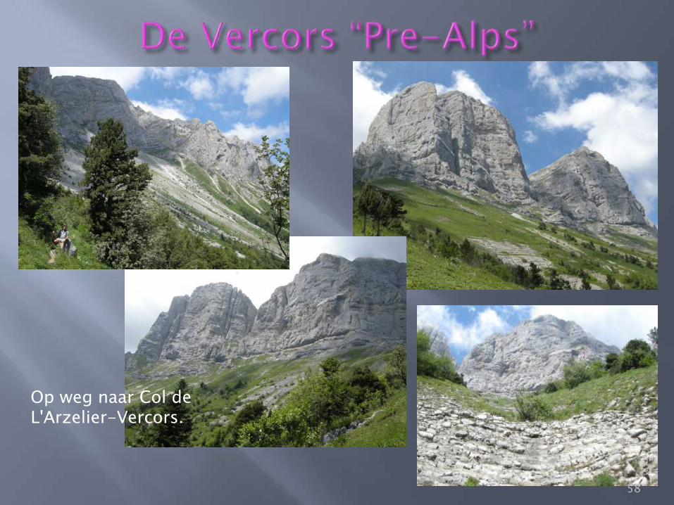
Op weg naar Col de L'Arzelier-Vercors.
58
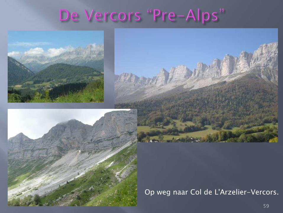
Op weg naar Col de L'Arzelier-Vercors.
59
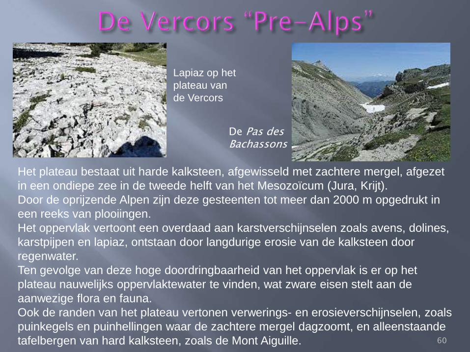
Het plateau bestaat uit harde kalksteen, afgewisseld met zachtere mergel, afgezet
in een ondiepe zee in de tweede helft van het Mesozoïcum (Jura, Krijt).
Door de oprijzende Alpen zijn deze gesteenten tot meer dan 2000 m opgedrukt in
een reeks van plooiingen.
Het oppervlak vertoont een overdaad aan karstverschijnselen zoals avens, dolines,
karstpijpen en lapiaz, ontstaan door langdurige erosie van de kalksteen door
regenwater.
Ten gevolge van deze hoge doordringbaarheid van het oppervlak is er op het
plateau nauwelijks oppervlaktewater te vinden, wat zware eisen stelt aan de
aanwezige flora en fauna.
Ook de randen van het plateau vertonen verwerings- en erosieverschijnselen, zoals
puinkegels en puinhellingen waar de zachtere mergel dagzoomt, en alleenstaande
tafelbergen van hard kalksteen, zoals de Mont Aiguille.
Lapiaz op het
plateau van
de Vercors
De Pas des Bachassons
60
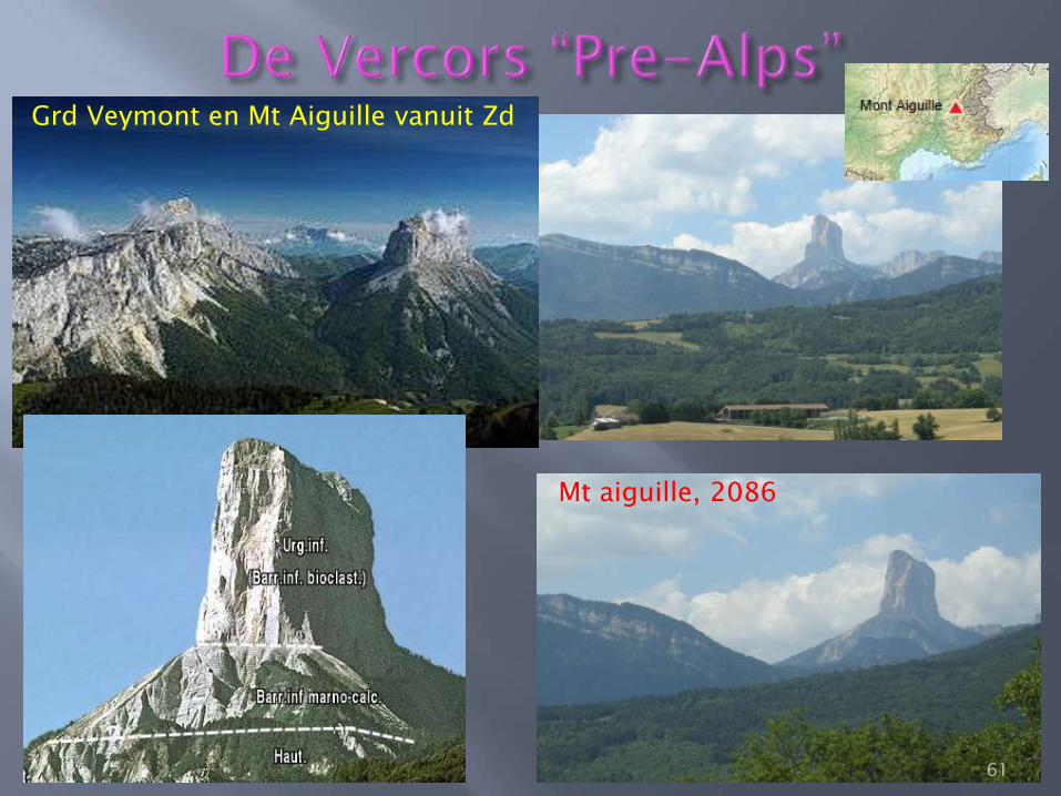
Mt aiguille, 2086
Grd Veymont en Mt Aiguille vanuit Zd
61
Geomorphologically, the mountain is a mesa-like outlier, that is to say, the
remains of a plateau that has been otherwise eroded to leave only a single
pillar of rock - weaker or fractured rocks (the so-called Jasneuf fault)[4] between
the current summit and the Vercors high plateau were eroded over time by over
400 metres, leaving the peak standing on its own.[5] This has resulted in
several unique features of Mont Aiguille, including the cliffs, which are almost
identical to those on the eastern edge of the Vercors Plateau such as those on
the edge of the Grand Veymont, which is the highest point of the range.[4][5]
Another feature resulting from this is the presence of meadows on the summit
plateau, which are similar to those to the west on the rest of the Vercors
plateau.[4]
Mont Aiguille is a limestone mesa, previously connected to the main body of the
high plateau of the Vercors Massif.[4][5] The summit is made up of lower
Barremian strata, deposited during the Cretaceous period.[4][6] This is the
same as the plateau to the west, but not as the immediate environs: the lower
slopes are composed of older Hauterivian strata.[6] As easily observed, the
bedding planes are all roughly level, although there is some inclination down to
the north-east.[6]
62
Herkenbaar?:
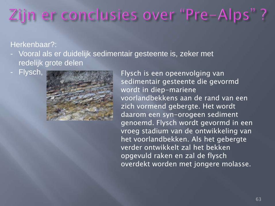
- Vooral als er duidelijk sedimentair gesteente is, zeker met
redelijk grote delen
- Flysch, Flysch is een opeenvolging van sedimentair gesteente die gevormd wordt in diep-mariene voorlandbekkens aan de rand van een zich vormend gebergte. Het wordt daarom een syn-orogeen sediment genoemd. Flysch wordt gevormd in een vroeg stadium van de ontwikkeling van het voorlandbekken. Als het gebergte verder ontwikkelt zal het bekken opgevuld raken en zal de flysch overdekt worden met jongere molasse.
63
64
• 1http://www.see.leeds.ac.uk/structure/internalalps/crosssection.htm
• 3 Holmes Principles---https://books.google.nl/books?id=E6vknq9SfIIC&pg=PT778&lpg=PT778&dq=geology+of+the+pre-alps&source=bl&ots=0U8SIUdPgx&sig=g-AToJmbwsVViv_A2v8GSpHEifM&hl=nl&sa=X&ved=0ahUKEwic59Sete_QAhVqIcAKHcR9Bxo4ChDoAQgLMAE#v=onepage&q=geology%20of%20the%20pre-alps&f=false
• 4 Geology of the Alps Part 2: General remarks; Penninic nappes, Lecture notes by Nikolaus Froitzheim, 2000
• 5 Alessandro Tenca, Introducing Mount Baldo: a mountain kissed by good fortune http://www.visitmalcesine.com/en/mount-baldo-geography-geology-history-weather-nature/117
• 6 Geology of the Alps Part 1: General remarks; Austroalpine nappes, Lecture notes by Nikolaus Froitzheim, 2000
• 7 The Alpine Tethys rifted margins: Reconciling old and new ideas to understand the stratigraphic architecture of magma-poor rifted margins, Emmanuel Masini, Gianreto Manatschal and Geoffroy Mohn Int. Ass. of Sedimentologists, Sedimentology, 60, 174–196, 2013 65
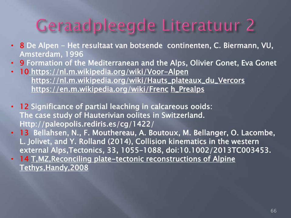
• 8 De Alpen - Het resultaat van botsende continenten, C. Biermann, VU, Amsterdam, 1996
• 9 Formation of the Mediterranean and the Alps, Olivier Gonet, Eva Gonet • 10 https://nl.m.wikipedia.org/wiki/Voor-Alpen
https://nl.m.wikipedia.org/wiki/Hauts_plateaux_du_Vercors https://en.m.wikipedia.org/wiki/Frenc h_Prealps
• 12 Significance of partial leaching in calcareous ooids: The case study of Hauterivian oolites in Switzerland. Http://paleopolis.rediris.es/cg/1422/
• 13 Bellahsen, N., F. Mouthereau, A. Boutoux, M. Bellanger, O. Lacombe, L. Jolivet, and Y. Rolland (2014), Collision kinematics in the western external Alps,Tectonics, 33, 1055–1088, doi:10.1002/2013TC003453.
• 14 T,MZ,Reconciling plate-tectonic reconstructions of Alpine Tethys,Handy,2008
66
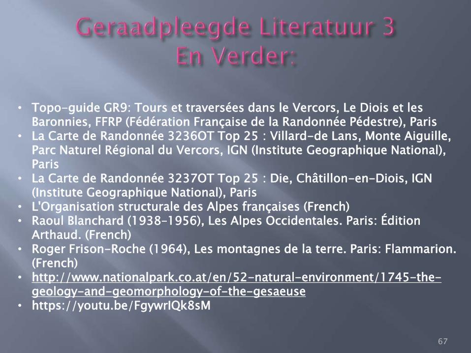
• Topo-guide GR9: Tours et traversées dans le Vercors, Le Diois et les Baronnies, FFRP (Fédération Française de la Randonnée Pédestre), Paris
• La Carte de Randonnée 3236OT Top 25 : Villard-de Lans, Monte Aiguille, Parc Naturel Régional du Vercors, IGN (Institute Geographique National), Paris
• La Carte de Randonnée 3237OT Top 25 : Die, Châtillon-en-Diois, IGN (Institute Geographique National), Paris
• L'Organisation structurale des Alpes françaises (French) • Raoul Blanchard (1938–1956), Les Alpes Occidentales. Paris: Édition
Arthaud. (French) • Roger Frison-Roche (1964), Les montagnes de la terre. Paris: Flammarion.
(French) • http://www.nationalpark.co.at/en/52-natural-environment/1745-the-
geology-and-geomorphology-of-the-gesaeuse • https://youtu.be/FgywrIQk8sM
67
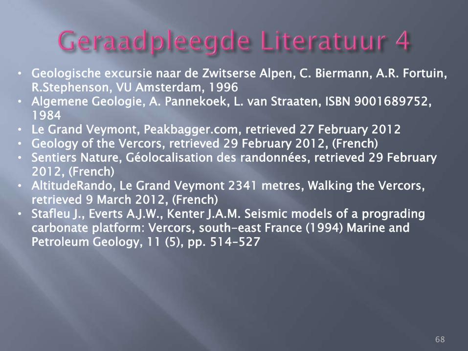
• Geologische excursie naar de Zwitserse Alpen, C. Biermann, A.R. Fortuin, R.Stephenson, VU Amsterdam, 1996
• Algemene Geologie, A. Pannekoek, L. van Straaten, ISBN 9001689752, 1984
• Le Grand Veymont, Peakbagger.com, retrieved 27 February 2012 • Geology of the Vercors, retrieved 29 February 2012, (French) • Sentiers Nature, Géolocalisation des randonnées, retrieved 29 February
2012, (French) • AltitudeRando, Le Grand Veymont 2341 metres, Walking the Vercors,
retrieved 9 March 2012, (French) • Stafleu J., Everts A.J.W., Kenter J.A.M. Seismic models of a prograding
carbonate platform: Vercors, south-east France (1994) Marine and Petroleum Geology, 11 (5), pp. 514–527
68
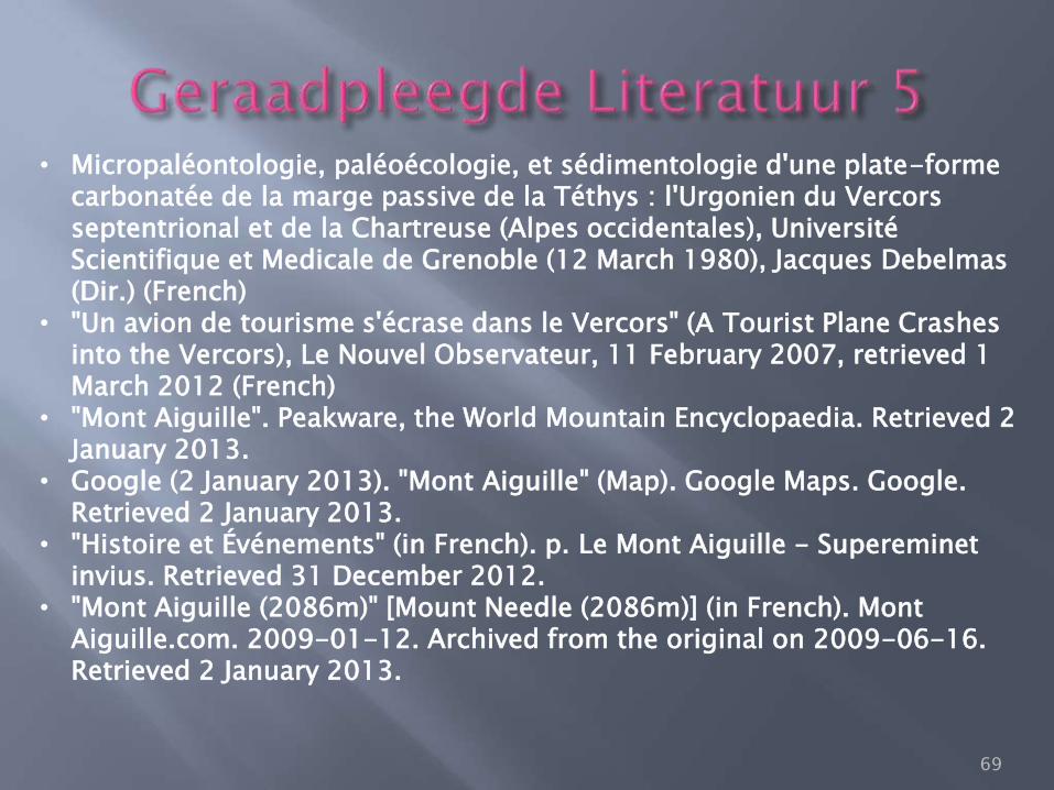
• Micropaléontologie, paléoécologie, et sédimentologie d'une plate-forme carbonatée de la marge passive de la Téthys : l'Urgonien du Vercors septentrional et de la Chartreuse (Alpes occidentales), Université Scientifique et Medicale de Grenoble (12 March 1980), Jacques Debelmas (Dir.) (French)
• "Un avion de tourisme s'écrase dans le Vercors" (A Tourist Plane Crashes into the Vercors), Le Nouvel Observateur, 11 February 2007, retrieved 1 March 2012 (French)
• "Mont Aiguille". Peakware, the World Mountain Encyclopaedia. Retrieved 2 January 2013.
• Google (2 January 2013). "Mont Aiguille" (Map). Google Maps. Google. Retrieved 2 January 2013.
• "Histoire et Événements" (in French). p. Le Mont Aiguille - Supereminet invius. Retrieved 31 December 2012.
• "Mont Aiguille (2086m)" [Mount Needle (2086m)] (in French). Mont Aiguille.com. 2009-01-12. Archived from the original on 2009-06-16. Retrieved 2 January 2013.
69
• "Mont Aiguille" (in French). Geol-Alp. 22 September 2011. Retrieved 31 December 2012.
• "L'ascension historique de 1492" [The historic ascent of 1492] (in French). Mont-Aiguille.com. 2009-01-12. Archived from the original on 2009-06-16. Retrieved 3 January 2013.
• Unsworth, Walt (1994). Hold the Heights: The Foundations of Mountaineering. Seattle: Penguin Books. pp. 19–20.
• "Alpinisme" [Alpinism] (in French). Mont Aiguille.com. 2009-01-12. Archived from the original on 2009-07-11. Retrieved 2 March 2013.
• IUCN Commission on National Parks and Protected Areas (November 1990). 1990 United Nations list of national parks and protected areas. IUCN. p. 89. ISBN 978-2-8317-0032-8. Retrieved 11 August 2011.
• Pfiffner, O.A.; 2009: Geologie der Alpen, Haupt Verlag, Berne, ISBN 978-3-8252-8416-9.
• Schmid, S.M.; Fügenschuh, B.; Kissling, E. & Schuster, R.; 2004: Tectonic map and overall architecture of the Alpine orogen, Eclogae Geologicae Helveticae 97, pp 93–117.
70