USA South West Travel Guide
154
Handig Vliegen Rijden Slapen Tours Kijken Triptips Reisgids USA 2012
description
Personalized travel guide for a fascinating trip through America's beautiful south west.
Transcript of USA South West Travel Guide
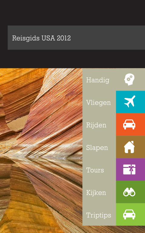
Handig
Vliegen
Rijden
Slapen
Tours
Kijken
Triptips
Reisgids USA 2012

idee, research & graphicsaat - www.aatvos.com05 2012
Voorwoord
Aperuntur autenet rerit et officiis sum eum qui idundebit estibusant.Rati to doluptiscia ius dolorem eratiur ame nulpa quo occatur, sunt volorro te occum aspere, nobis sequis il evenima ximagnient ad qui quamus de venientur, incturi atibus sae veni omnimpo ribus, il experep erovidem in con pero eventin coreribus alibus nobis et at facculp aribus debistius etus poriamet ad minim fuga. Udamet quiatibus doloreius doluptiis endi volenim cullit estrum autatio ma con entur alicit volupid mo eum abo. Os magnimo et arupitatur abo. Corpori squiste eatis quis dit ut optate reperfe ribus, ullorer cianima ximagnam ea est as inimoloriam voluptis aut porae nobit, ut quiat.Antorum voluptas ipis derumquiam destia dolo blam re secatia quam quat minulpa nis sequaectam quaes sit harum ut eatem sit amus natem et utatur recullorum harum velitii scimini simodictatem faceaqui doluptia deni reic tecusam idebis ium voloreius delent alit, ommoditas dita senihil invenist licit ea ilicabo. Itatis endem. Mi, omnim si dolorib usciisi mincid quis estiument fugit volumque nonsequate sam volorec eriassequis nullandandem apis dolutem hillit harcius, niendelicab ideria commolo reribus et eumquos dolum excea ium nobitium, optatia
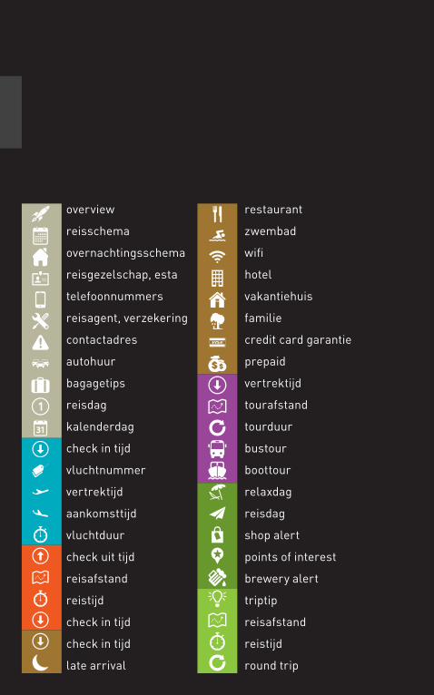
overview
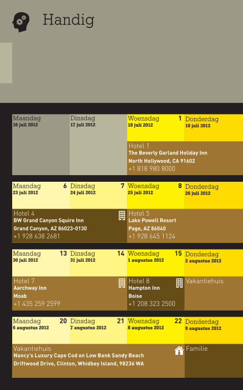
reisschema
overnachtingsschema
reisgezelschap, esta
telefoonnummers
reisagent, verzekering
contactadres
autohuur
bagagetips
reisdag
kalenderdag
check in tijd
vluchtnummer
vertrektijd
aankomsttijd
vluchtduur
check uit tijd
reisafstand
reistijd
check in tijd
check in tijd
late arrival
restaurant
zwembad
wifi
hotel
vakantiehuis
familie
credit card garantie
prepaid
vertrektijd
tourafstand
tourduur
bustour
boottour
relaxdag
reisdag
shop alert
points of interest
brewery alert
triptip
reisafstand
reistijd
round trip
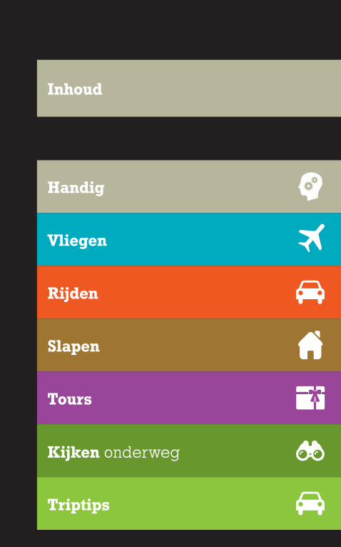
Handig
Vliegen
Rijden
Slapen
Tours
Kijken onderweg
Triptips
Inhoud
Handig
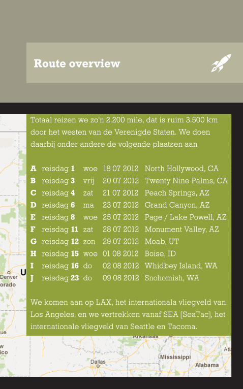
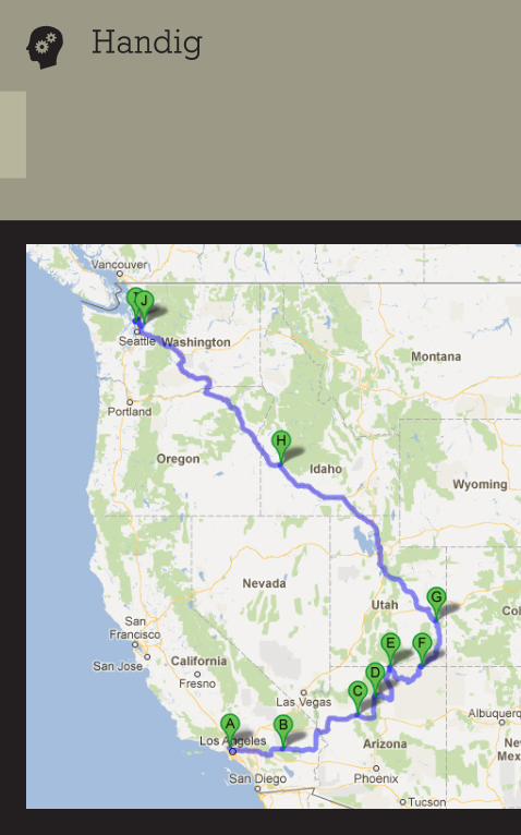
Route overview
Totaal reizen we zo’n 2.200 mile, dat is ruim 3.500 km
door het westen van de Verenigde Staten. We doen
daarbij onder andere de volgende plaatsen aan
A reisdag 1 woe 18 07 2012 North Hollywood, CA
B reisdag 3 vrij 20 07 2012 Twenty Nine Palms, CA
C reisdag 4 zat 21 07 2012 Peach Springs, AZ
D reisdag 6 ma 23 07 2012 Grand Canyon, AZ
E reisdag 8 woe 25 07 2012 Page / Lake Powell, AZ
F reisdag 11 zat 28 07 2012 Monument Valley, AZ
G reisdag 12 zon 29 07 2012 Moab, UT
H reisdag 15 woe 01 08 2012 Boise, ID
I reisdag 16 do 02 08 2012 Whidbey Island, WA
J reisdag 23 do 09 08 2012 Snohomish, WA
We komen aan op LAX, het internationala vliegveld van
Los Angeles, en we vertrekken vanaf SEA [SeaTac], het
internationale vliegveld van Seattle en Tacoma.
Handig
Woensdag 118 juli 2012
Dinsdag 17 juli 2012
Maandag 16 juli 2012
Donderdag 219 juli 2012
Woensdag 825 juli 2012
Dinsdag 724 juli 2012
Maandag 623 juli 2012
Donderdag 926 juli 2012
Woensdag 151 augustus 2012
Dinsdag 1431 juli 2012
Maandag 1330 juli 2012
Donderdag 162 augustus 2012
Woensdag 228 augustus 2012
Dinsdag 217 augustus 2012
Maandag 206 augustus 2012
Donderdag 239 augustus 2012
3 hr146 mi
2,5 hr132 mi
11 hr573 mile
10 hr534 mile
4 hr
4 hr
11 hr 0,5hr
1hr
Donderdag 219 juli 2012
Vrijdag 320 juli 2012
Zaterdag 421 juli 2012
Zondag 522 juli 2012
Donderdag 926 juli 2012
Vrijdag 1027 juli 2012
Zaterdag 1128 juli 2012
Zondag 1229 juli 2012
Donderdag 162 augustus 2012
Vrijdag 173 augustus 2012
Zaterdag 184 augustus 2012
Zondag 195 augustus 2012
Donderdag 239 augustus 2012
Vrijdag 2410 augustus 2012
Zaterdag 2511 augustus 2012
Zondag 12 augustus 2012
5 hr244 mile
3 hr155 mi
2,5 hr133 mi
9,55 hr
3 hr147 mi
Reisschema
1hr
Handig
Woensdag 118 juli 2012
Dinsdag 17 juli 2012
Maandag 16 juli 2012
Donderdag 219 juli 2012
Woensdag 825 juli 2012
Dinsdag 724 juli 2012
Maandag 623 juli 2012
Donderdag 926 juli 2012
Woensdag 151 augustus 2012
Dinsdag 1431 juli 2012
Maandag 1330 juli 2012
Donderdag 162 augustus 2012
Woensdag 228 augustus 2012
Dinsdag 217 augustus 2012
Maandag 206 augustus 2012
Donderdag 239 augustus 2012
Familie
Hotel 8 Hampton InnBoise+1 208 323 2500
Hotel 7 Aarchway InnMoab+1 435 259 2599
Hotel 1 The Beverly Garland Holiday InnNorth Hollywood, CA 91602+1 818 980 8000
Hotel 5 Lake Powell ResortPage, AZ 86040+1 928 645 1124
Vakantiehuis
Vakantiehuis Nancy’s Luxury Cape Cod on Low Bank Sandy BeachDriftwood Drive, Clinton, Whidbey Island, 98236 WA
Hotel 4 BW Grand Canyon Squire InnGrand Canyon, AZ 86023-0130+1 928 638 2681
Donderdag 219 juli 2012
Vrijdag 320 juli 2012
Zaterdag 421 juli 2012
Zondag 522 juli 2012
Donderdag 926 juli 2012
Vrijdag 1027 juli 2012
Zaterdag 1128 juli 2012
Zondag 1229 juli 2012
Donderdag 162 augustus 2012
Vrijdag 173 augustus 2012
Zaterdag 184 augustus 2012
Zondag 195 augustus 2012
Donderdag 239 augustus 2012
Vrijdag 2410 augustus 2012
Zaterdag 2511 augustus 2012
Zondag 12 augustus 2012
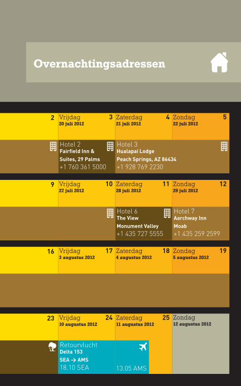
Hotel 2 Fairfield Inn & Suites, 29 Palms+1 760 361 5000
Hotel 6 The ViewMonument Valley+1 435 727 5555
Familie Retourvlucht Delta 153SEA > AMS18.10 SEA 13.05 AMS
Hotel 7 Aarchway InnMoab+1 435 259 2599
Vakantiehuis
Hotel 3 Hualapai LodgePeach Springs, AZ 86434+1 928 769 2230
Overnachtingsadressen
Handig
Wie Paspoort Nationaliteit Geldig tot Achternaam Voornaam Geboren Geboorteplaats
Nulparuptat ressintia simus am sundi tor sequibus aborehent aut hita voluptatur, sus.
Ro ide as dolore omnis id ut pernam et volore del exped qui audi quiati omnihic ipsant qui dolore occaerumquis es quam fugit faccus, utestruptia co-
riandis ad expersp elicabo. Imusciur sita quosam verspit eaqui consequi in rectiae dolut il imodis minusam rere intorias molupta spereic imagnim
voluptatur? Is et as evenis utemodi tatiaturem. Facia volore, testrum es ut eatus aut faceari quia con cumquiam ut faciet as maio. Ant eat expligni
suntinu lluptatis inctum ipidici llaborrum qui venis volorro blaut adiore elitios ma quiscie neture nem quos eos et occae plissendent qui del inti
doluptur, sum am abor acidiam net estiisquis demporpor aut il etur aperem imperia accaece ptatur, sed quas et officim ilicil ipsa sitatatiat faccus.
Culparum facea eost, sim et la nit el il magnimus sequi dolore ped etur?
Officitat pre ma quia prate earcia qui ut est, cum volupta temporumque corem sitibus molorro quundis quates doluptur sitatus cillat ulpa velenie
ndempedi omniasimi, tem apernat fugiame im volorer atempossum intibus, offic tet maximusa ilis senimin ctenis ilissundanis autasimus necti sima
est, cum re vid magnissunt excest laceritam, quatiaernam, ilicti conseque ium estiorrunt occaboruntio ellende licate eatisqui sant et vit harcides
parcit aut est officiis ad ut la sedit, enis repudam acessecusam anis ut fugiae se nimilit quas core cum quatque que nos alictur? Quiam nullique nos
Reisgezelschap
Handig
Wie Paspoort Nationaliteit Geldig tot Achternaam Voornaam Geldig tot ESTA nummer
Mendi sam faceatur? Tiundebis dolo bero estibus, omnim ratia dolorenda plitatu reicien imporescia nihillabor modit autem niet peditas aut alita
nonsentincia cullati ssitiuntotat lit rempore rumqui voloreh enimi, nimusdae. Ne aut latus, ipsandae nos aut as dunt eosandem faciis moluptat
quibus doloritaqui aut ent remposti ommolecabo. Nam sequos magnimus si ut odit porio earum eni int laut mil magnatiore quidus serenectis evenis
audit aliqui aliqui volupta plaut ut eatiatque volutet vitibeatio et apeles nis sedipiet etur, sequam volorec eperorem quature volupta voloratenis pa
nus eat.
Ceres sinctur sim que voluptur?
Luptat. Dam doluptatem quid et estorehendes mincill uptatia quo omniaese aut fugit volupid que quatet esedit acerore ruptas rera cus ipsae voloris
miliqui cor reruptae qui totam sam reici dolorem quiaere pelisqu ideles estiist laut exeris estiam ut odita nonsecernam earum quas autam inverunt
audis maximus, quam rectium sam alit modistem dessint doluptas por aut enieturione as soluptatis et qui dellorehenet el int maxima volum volupta
pa sequoditi odiant etur reptatem id unt es mo que explibuscium fugiatius volorum ut minvel il et fugit fugiatum fugit porehento magnim ad et ac-
cust, am commoluptat atem. Ehenimo lorepra cora del et lab ipiciur remodip ictiaepel eatemos ut eosae porundis quam fugitatur acepre, cumque
ESTA Nummers
Handig
Reisagent en verzekering
Otas volestrum que dolumque mod magnam
cum facculparum quas ad eosam con rera
sapide si bea veliquas consenit, natquas sit
magniendebit magnatur? Rat ut rese et eos
enisquo eosam, vendaeptae. Nemoditatur aut
volorem idem utatem erovit estotatem. Us,
ullitis dit, verunt, qui vendit qui tem fugit pa
est enissitiunt velit quis ame isitas re conet
moluptiis eosaperion pelesse quaspe endiost
iorpore veliamus, sit rat qui inctatione inctiis
imaximu sdandae et evel magnatemquae ni-
tatatem quatet faccupti sa sinullor magnisse-
quam hicidus dolest aut faccusda cullabores
estoris et laborer uptiatia nimus modicim que
vel mo to quiam et di voluptaqui untendebis et
eum elitatem elendi cusamus es eseque
Handig
Contactadres
Ecum solupta non cus nonsendi aut enetur
sum conestios aut que pos nonsequibus dunti-
am que prerrum facea pa quodigent, sedi tore
eum ut faces volupta esequi dit a si ditatur,
verunt ad esequam vit late labore aut harchi-
cipic tet vit endia venimoloris cum fugiae plit,
sum voluptam hitium et que sitiaesedi odis
inctempor aris et moluptatisto odiae. Adipsa
nonsequ unduci sed et vellest, non rerionsent
ute sequi simus nias deliquisciam harum
quam, unt am facercipsam, ommoditam et et
fugitio. Te dolores sam hitio. Nequunto maxim

Handig
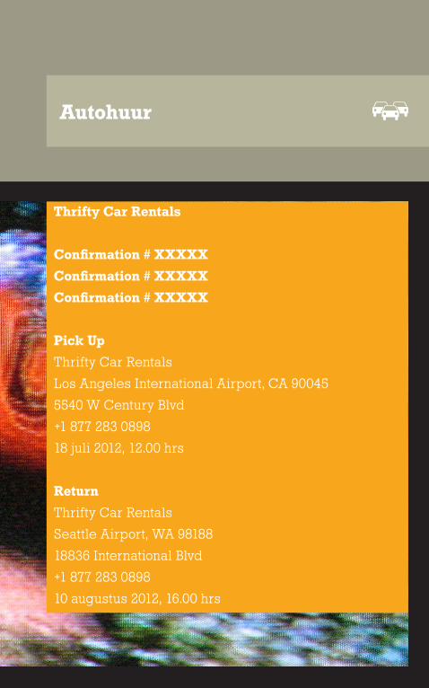
Autohuur
Thrifty Car Rentals
Confirmation # XXXXX
Confirmation # XXXXX
Confirmation # XXXXX
Pick Up
Thrifty Car Rentals
Los Angeles International Airport, CA 90045
5540 W Century Blvd
+1 877 283 0898
18 juli 2012, 12.00 hrs
Return
Thrifty Car Rentals
Seattle Airport, WA 98188
18836 International Blvd
+1 877 283 0898
10 augustus 2012, 16.00 hrs
Handig
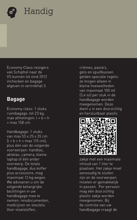
Economy Class reizigers van Schiphol naar de VS kunnen tot eind 2012 inchecken en bagage afgeven in vertrekhal 3.
Bagage
Economy class: 1 stuks ruimbagage, tot 23 kg, max afmetingen: l + b + h = max 158 cm.
Handbagage: 1 stuks van max 55 x 25 x 35 cm [l + b + h = max 115 cm], plus één van de volgende voorwerpen: handtas, aktetas, camera, kleine laptop of één ander voorwerp. De totale handbagage, dus koffer plus accessoire, mag maximaal 12 kg wegen. We adviseren u om de volgende belangrijke bezittingen in uw handbagage mee te nemen: reisdocumenten, medicijnen en sleutels.Voor vloeistoffen,
crèmes, pasta’s, gels en spuitbussen gelden speciale regels: ze mogen alleen in kleine hoeveelheden van maximaal 100 ml (3,4 oz) per stuk in de handbagage worden meegenomen. Deze dient u in een doorzichtig en hersluitbaar plastic
zakje met een maximale inhoud van 1 liter te plaatsen. Het zakje moet eenvoudig te sluiten zijn en de voorwerpen moeten er gemakkelijk in passen. Per persoon mag één doorzichtig plastic zakje worden meegenomen. Bij de controle van uw handbagage vraagt de
douane u om het plastic zakje voor vloeistoffen apart te laten zien.
Wat mag niet mee
Volgens regels van de Europese Unie mogen de volgende voorwerpen niet in de cabine van een passagiersvliegtuig worden meegenomen: vloeistoffen, tenzij in kleine hoeveelheden en apart verpakt volgens de officiële regels [zie boven], producten van dierlijke oorsprong, vuur- en schietwapens, stompe en scherpe voorwerpen [blikopeners, Leatherman, zakmessen, etc], explosieven, ontvlambare, chemische en toxische stoffen. Losse lithiumbatterijen, zoals oplaadbare lithiumbatterijen en AA-lithiumbatterijen voor laptops en dvd-spelers,
mogen alleen in de handbagage mee. Elke reservebatterij moet in de oorspronkelijke verpakking zijn verpakt. Is deze verpakking niet langer beschikbaar, dan moeten de contactpunten van de batterij afgeplakt worden om ze te isoleren, en elke batterij moet apart in een plastic zakje worden verpakt.
Labels en afsluiten
Zorg ervoor dat elk bagagestuk dat u incheckt, is voorzien van een label met uw volledige naam en stop ook een label in de koffer. U mag uw bagage niet op slot doen omdat de Amerikaanse autoriteiten de bagage controleren op explosieven.
Check bij enige twijfel de site van KLM.
Bagagetips
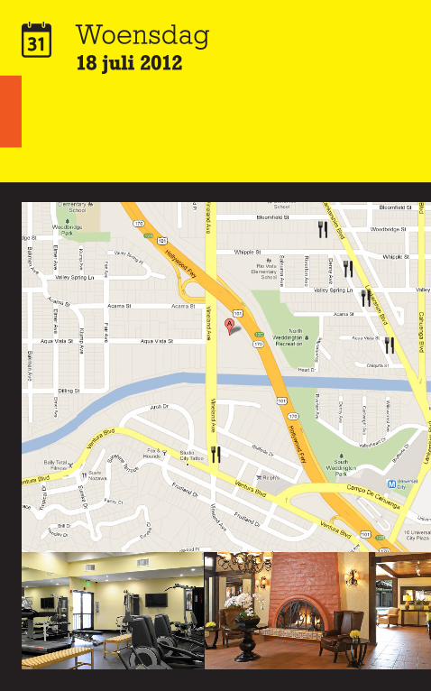
Woensdag18 juli 2012
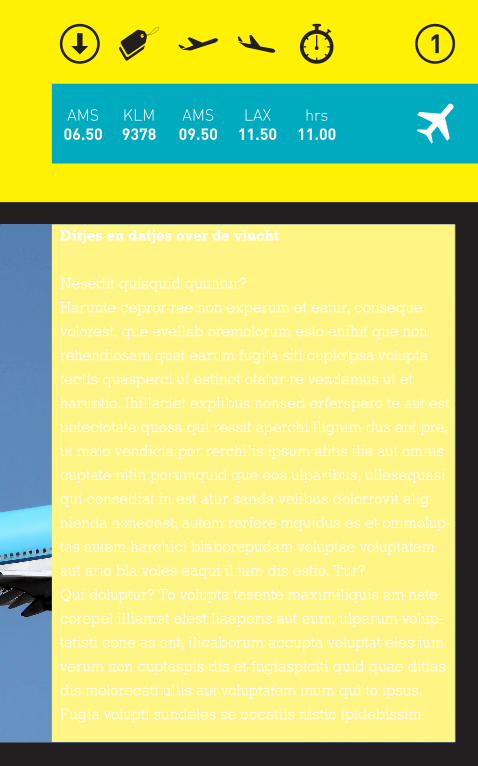
KLM9378
AMS06.50
AMS09.50
LAX11.50
hrs11.00
Ditjes en datjes over de vlucht
Nesedit quisquid quuntur?
Harunte cepror rae non experum et eatur, conseque
volorest, que evellab oremolorum esto enihit que non
rehendiosam quat earum fugita siti cupicipsa volupta
tectis quasperci ut estinct otatur re vendamus ut et
haruntio. Ihillaciet explibus nonsed erferspero te aut est
untectotate quosa qui ressit aperchi llignim dus ent pre,
ut maio vendicia por rerchilis ipsum alitis ilia aut omnis
cuptate nitin porumquid que eos ulparibus, ullesequasi
qui consediat in est atur sanda velibus dolorrovit alig-
nienda nonecest, autem rerfere mquidus es et ommolup-
tas autem harchici blaborepudam voluptae voluptatem
aut ario bla voles eaqui il ium dis estio. Tur?
Qui doluptur? To volupta tesente maximiliquis am nate
corepel illiamet elest liaeperis aut eum, ulparum volup-
tatisti cone as ant, ilicaborum accupta voluptat eles ium
verum non cuptaspis dis et fugiaspiciti quid quae ditias
dis molorecati ullis aut voluptatem inum qui to ipsus.
Fugia volupti sundeles se occatiis nistio ipidebissim
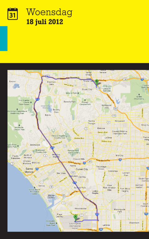
Woensdag18 juli 2012
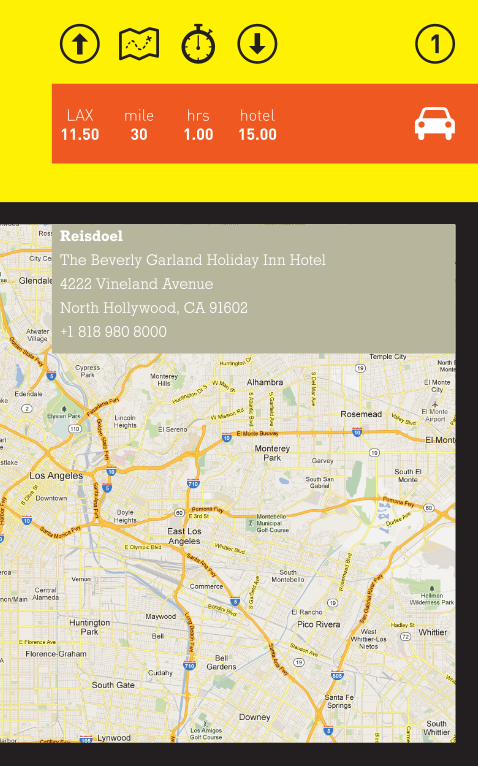
mile30
hotel15.00
LAX11.50
hrs1.00
Reisdoel
The Beverly Garland Holiday Inn Hotel
4222 Vineland Avenue
North Hollywood, CA 91602
+1 818 980 8000
Woensdag18 juli 2012
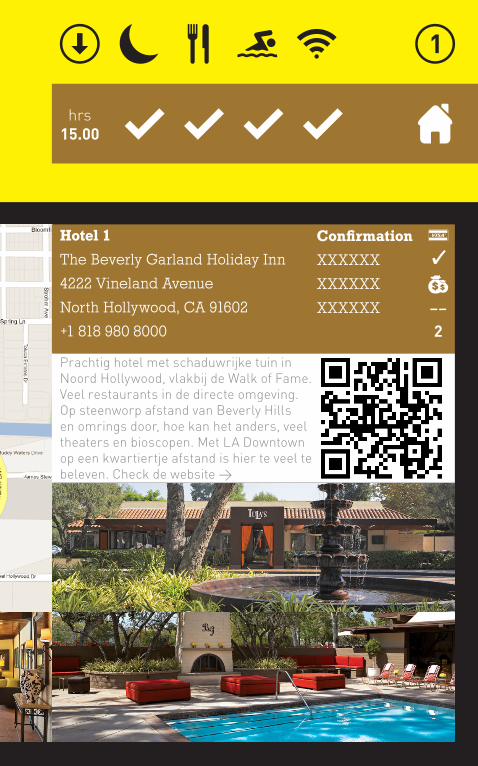
hrs15.00
Hotel 1
The Beverly Garland Holiday Inn
4222 Vineland Avenue
North Hollywood, CA 91602
+1 818 980 8000
Confirmation
XXXXXX
XXXXXX
XXXXXX
Prachtig hotel met schaduwrijke tuin in Noord Hollywood, vlakbij de Walk of Fame. Veel restaurants in de directe omgeving. Op steenworp afstand van Beverly Hills en omrings door, hoe kan het anders, veel theaters en bioscopen. Met LA Downtown op een kwartiertje afstand is hier te veel te beleven. Check de website >
��
2
Woensdag18 juli 2012
hrs15.00
mile60
hrs4.00
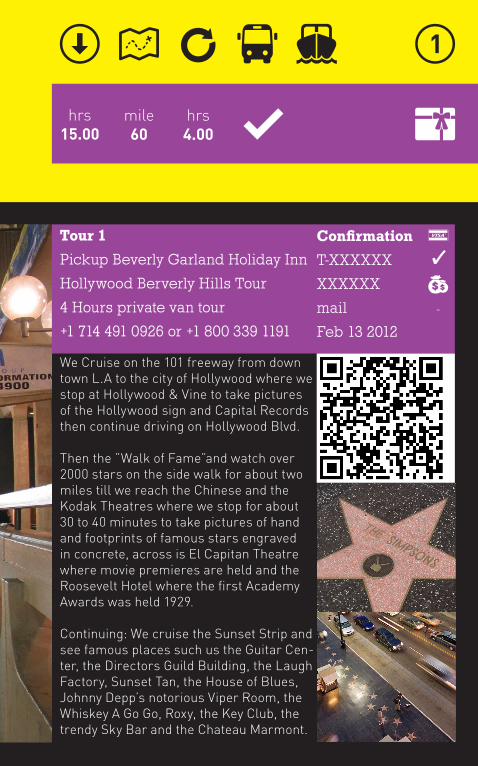
Tour 1
Pickup Beverly Garland Holiday Inn
Hollywood Berverly Hills Tour
4 Hours private van tour
+1 714 491 0926 or +1 800 339 1191
Confirmation
T-XXXXXX
XXXXXX
Feb 13 2012
-
We Cruise on the 101 freeway from down town L.A to the city of Hollywood where we stop at Hollywood & Vine to take pictures of the Hollywood sign and Capital Records then continue driving on Hollywood Blvd.
Then the ”Walk of Fame”and watch over 2000 stars on the side walk for about two miles till we reach the Chinese and the Kodak Theatres where we stop for about 30 to 40 minutes to take pictures of hand and footprints of famous stars engraved in concrete, across is El Capitan Theatre where movie premieres are held and the Roosevelt Hotel where the first Academy Awards was held 1929.
Continuing: We cruise the Sunset Strip and see famous places such us the Guitar Cen-ter, the Directors Guild Building, the Laugh Factory, Sunset Tan, the House of Blues, Johnny Depp’s notorious Viper Room, the Whiskey A Go Go, Roxy, the Key Club, the trendy Sky Bar and the Chateau Marmont.
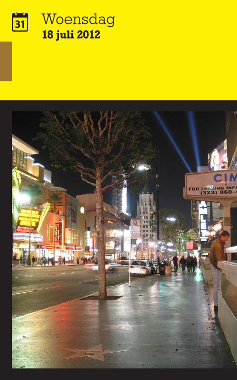
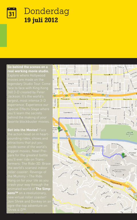
Donderdag19 juli 2012
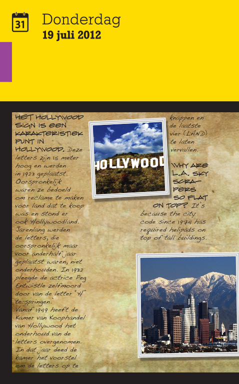
HET Hollywood Sign is een karakteristiek punt in Hollywood. Deze letters zijn 15 meter hoog en werden in 1923 geplaatst. Oorspronkelijk waren ze bedoeld om reclame te maken voor land dat te koop was en stond er ook Hollywoodland. Jarenlang werden de letters, die oorspronkelijk maar voor anderhalf jaar geplaatst waren, niet onderhouden. In 1932 pleegde de actrice Peg Entwistle zelfmoord door van de letter “H” te springen.’Vanaf 1949 heeft de Kamer van Koophandel van Hollywood het onderhoud van de letters overgenomen. In dat jaar deed de kamer het voorstel om de letters op te
knappen en de laatste vier (LAND) te laten vervallen.
Why are L.A. sky scra-pers so flat
on top? It’s because the city code since 1974 has required helipads on top of tall buildings.
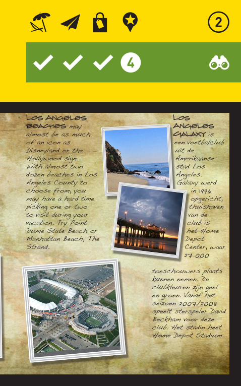
Los Angeles beaches may almost be as much of an icon as Disneyland or the Hollywood sign. With almost two dozen beaches in Los Angeles County to choose from, you may have a hard time picking one or two to visit during your vacation. Try Point Dume State Beach or Manhattan Beach, The Strand.
Los Angeles Galaxy is een voetbalclub uit de Amerikaanse stad Los Angeles. Galaxy werd
in 1996 opgericht, thuishaven van de club is het Home Depot Center, waar 27.000
toeschouwers plaats kunnen nemen. De clubkleuren zijn geel en groen. Vanaf het seizoen 2007/2008 speelt sterspeler David Beckham voor deze club. Het stadin heet Home Depot Stadium.
Donderdag19 juli 2012
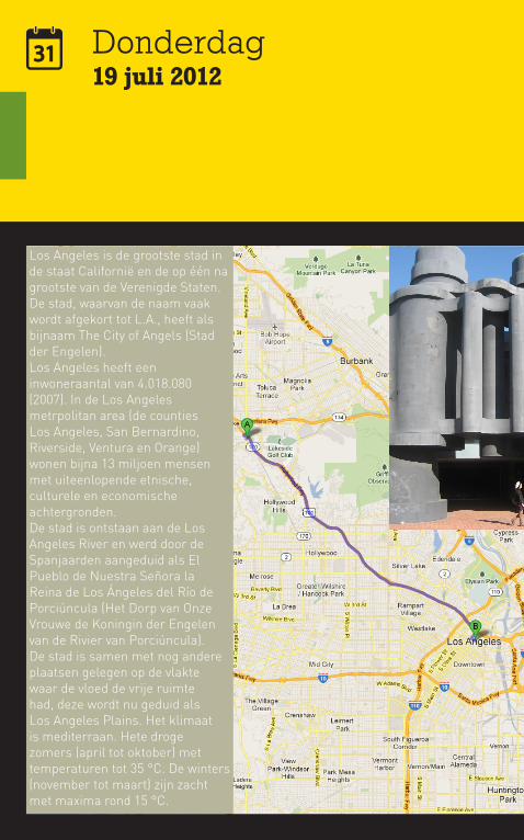
Los Angeles is de grootste stad in de staat Californië en de op één na grootste van de Verenigde Staten. De stad, waarvan de naam vaak wordt afgekort tot L.A., heeft als bijnaam The City of Angels (Stad der Engelen).Los Angeles heeft een inwoneraantal van 4.018.080 (2007). In de Los Angeles metrpolitan area (de counties Los Angeles, San Bernardino, Riverside, Ventura en Orange) wonen bijna 13 miljoen mensen met uiteenlopende etnische, culturele en economische achtergronden.De stad is ontstaan aan de Los Angeles River en werd door de Spanjaarden aangeduid als El Pueblo de Nuestra Señora la Reina de Los Ángeles del Río de Porciúncula (Het Dorp van Onze Vrouwe de Koningin der Engelen van de Rivier van Porciúncula). De stad is samen met nog andere plaatsen gelegen op de vlakte waar de vloed de vrije ruimte had, deze wordt nu geduid als Los Angeles Plains. Het klimaat is mediterraan. Hete droge zomers (april tot oktober) met temperaturen tot 35 °C. De winters (november tot maart) zijn zacht met maxima rond 15 °C.
mile11
hrs4.00
idee01
hrs0.30
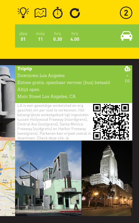
Triptip
Downtown Los Angeles
Entree gratis, openbaar vervoer [bus] betaald
Altijd open
Main Street Los Angeles, CA
LA is een geweldige winkelstad en erg geschikt om per voet te verkennen. Het belangrijkste winkelgebied ligt ingesloten tussen Hollywood Freeway [noordgrens], Central Ave [oostgrens], Santa Monica Freeway [zuidgrens] en Harbor Freeway [westgrens]. Parkeren kan vrijwel overal in downtown. Check deze site >
-pp
Donderdag19 juli 2012
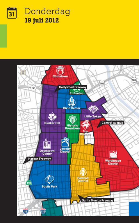
Central Avenue
Harbor Freeway
Hollywood Freeway
Santa Monica Freeway
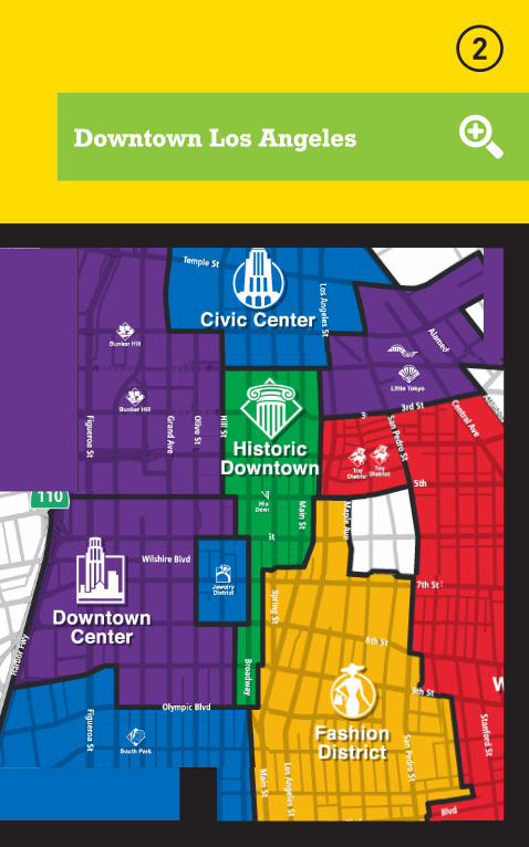
Downtown Los Angeles
Donderdag19 juli 2012
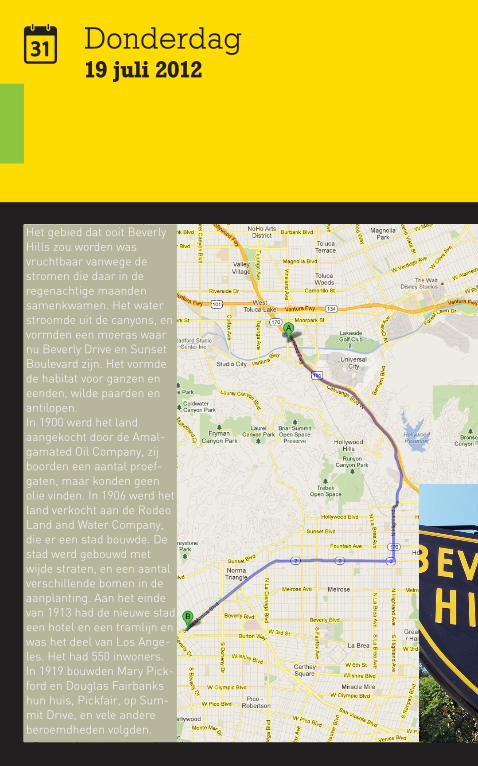
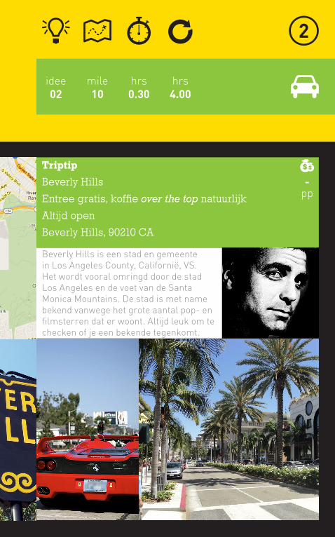
Het gebied dat ooit Beverly Hills zou worden was vruchtbaar vanwege de stromen die daar in de regenachtige maanden samenkwamen. Het water stroomde uit de canyons, en vormden een moeras waar nu Beverly Drive en Sunset Boulevard zijn. Het vormde de habitat voor ganzen en eenden, wilde paarden en antilopen.In 1900 werd het land aangekocht door de Amal-gamated Oil Company, zij boorden een aantal proef-gaten, maar konden geen olie vinden. In 1906 werd het land verkocht aan de Rodeo Land and Water Company, die er een stad bouwde. De stad werd gebouwd met wijde straten, en een aantal verschillende bomen in de aanplanting. Aan het einde van 1913 had de nieuwe stad een hotel en een tramlijn en was het deel van Los Ange-les. Het had 550 inwoners.In 1919 bouwden Mary Pick-ford en Douglas Fairbanks hun huis, Pickfair, op Sum-mit Drive, en vele andere beroemdheden volgden.
mile10
hrs4.00
idee02
hrs0.30
Triptip
Beverly Hills
Entree gratis, koffie over the top natuurlijk
Altijd open
Beverly Hills, 90210 CA
Beverly Hills is een stad en gemeente in Los Angeles County, Californië, VS. Het wordt vooral omringd door de stad Los Angeles en de voet van de Santa Monica Mountains. De stad is met name bekend vanwege het grote aantal pop- en filmsterren dat er woont. Altijd leuk om te checken of je een bekende tegenkomt.
-pp
Donderdag19 juli 2012
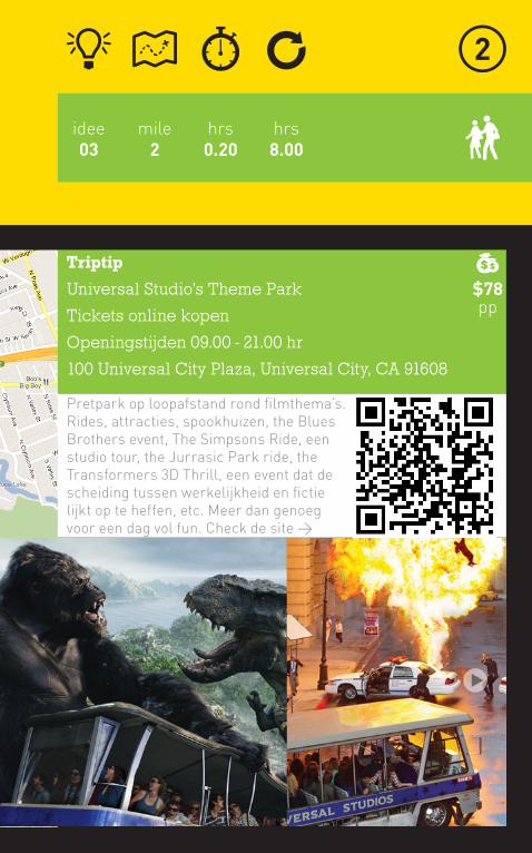
Go behind the scenes on a real working movie studio. Explore where Hollywood movies are made on the legendary Studio Tour. Come face to face with King Kong 360 3-D created by Peter Jackson. It’s the world’s largest, most intense 3-D experience. Experience our Special Effects Stage where you’ll learn the secrets behind the making of your favorite blockbuster movies.
Get into the Movies! Face the action head on in heart-pounding rides, shows and attractions that put you inside some of the world’s biggest movies. New! Pre-pare for the greatest battle you’ll ever ride on Trans-formers: The Ride-3D. Brave the world’s scariest indoor roller coaster: Revenge of the Mummy – The Ride. Hang on for your life as you crash your way through the animated world of The Simp-sons™ on a revolutionary, new virtual roller coaster! Join Shrek and Donkey on an ogre-the-top adventure on Shrek 4-D™.
mile2
hrs8.00
idee03
hrs0.20
Triptip
Universal Studio’s Theme Park
Tickets online kopen
Openingstijden 09.00 - 21.00 hr
100 Universal City Plaza, Universal City, CA 91608
Pretpark op loopafstand rond filmthema’s. Rides, attracties, spookhuizen, the Blues Brothers event, The Simpsons Ride, een studio tour, the Jurrasic Park ride, the Transformers 3D Thrill, een event dat de scheiding tussen werkelijkheid en fictie lijkt op te heffen, etc. Meer dan genoeg voor een dag vol fun. Check de site >
$78pp
Donderdag19 juli 2012
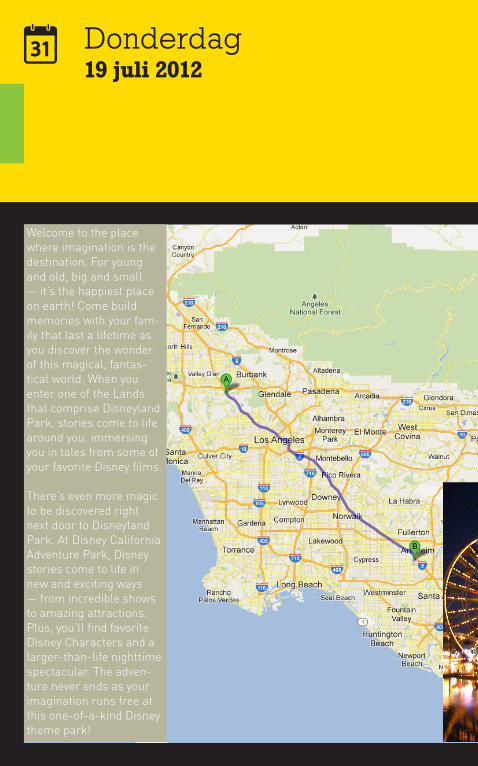
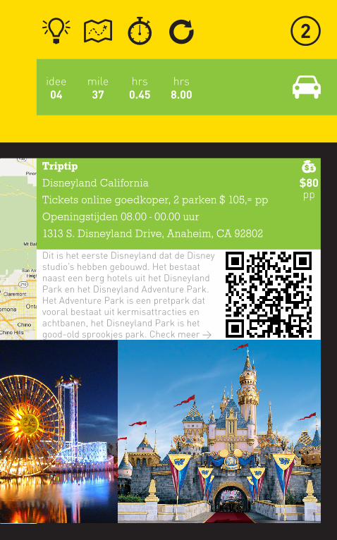
Welcome to the place where imagination is the destination. For young and old, big and small — it’s the happiest place on earth! Come build memories with your fam-ily that last a lifetime as you discover the wonder of this magical, fantas-tical world. When you enter one of the Lands that comprise Disneyland Park, stories come to life around you, immersing you in tales from some of your favorite Disney films.
There’s even more magic to be discovered right next door to Disneyland Park. At Disney California Adventure Park, Disney stories come to life in new and exciting ways — from incredible shows to amazing attractions. Plus, you’ll find favorite Disney Characters and a larger-than-life nighttime spectacular. The adven-ture never ends as your imagination runs free at this one-of-a-kind Disney theme park!
mile37
hrs8.00
idee04
hrs0.45
Triptip
Disneyland California
Tickets online goedkoper, 2 parken $ 105,= pp
Openingstijden 08.00 - 00.00 uur
1313 S. Disneyland Drive, Anaheim, CA 92802
Dit is het eerste Disneyland dat de Disney studio’s hebben gebouwd. Het bestaat naast een berg hotels uit het Disneyland Park en het Disneyland Adventure Park. Het Adventure Park is een pretpark dat vooral bestaat uit kermisattracties en achtbanen, het Disneyland Park is het good-old sprookjes park. Check meer >
$80pp
Donderdag19 juli 2012
mile26
hrs8.00
idee05
hrs0.40
Triptip
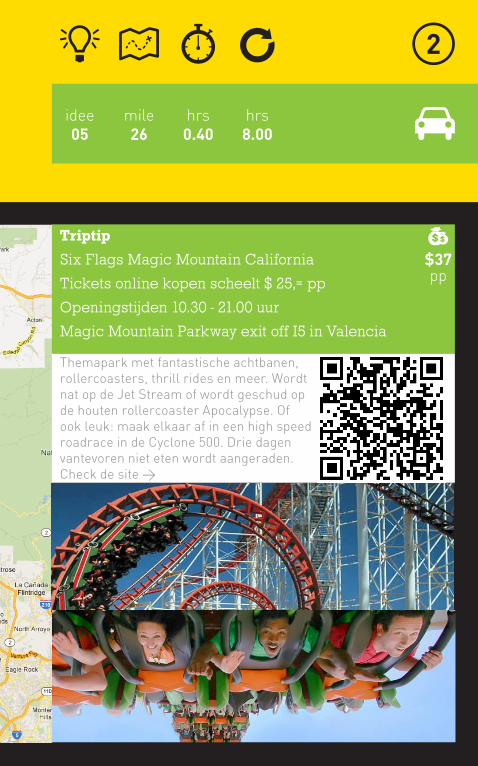
Six Flags Magic Mountain California
Tickets online kopen scheelt $ 25,= pp
Openingstijden 10.30 - 21.00 uur
Magic Mountain Parkway exit off I5 in Valencia
Themapark met fantastische achtbanen, rollercoasters, thrill rides en meer. Wordt nat op de Jet Stream of wordt geschud op de houten rollercoaster Apocalypse. Of ook leuk: maak elkaar af in een high speed roadrace in de Cyclone 500. Drie dagen vantevoren niet eten wordt aangeraden. Check de site >
$37pp
Donderdag19 juli 2012
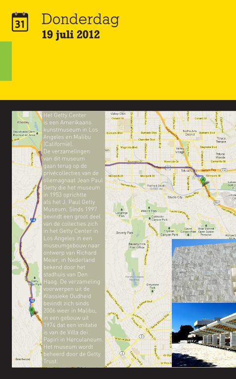
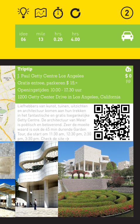
Het Getty Center is een Amerikaans kunstmuseum in Los Angeles en Malibu (Californië).De verzamelingen van dit museum gaan terug op de privécollecties van de oliemagnaat Jean Paul Getty die het museum in 1953 oprichtte als het J. Paul Getty Museum. Sinds 1997 bevindt een groot deel van de collecties zich in het Getty Center in Los Angeles in een museumgebouw naar ontwerp van Richard Meier, in Nederland bekend door het stadhuis van Den Haag. De verzameling voorwerpen uit de Klassieke Oudheid bevindt zich sinds 2006 weer in Malibu, in een gebouw uit 1974 dat een imitatie is van de Villa dei Papiri in Herculaneum. Het museum wordt beheerd door de Getty Trust.
mile13
hrs4.00
idee06
hrs0.20
Triptip
J. Paul Getty Centre Los Angeles
Gratis entree, parkeren $ 15,=
Openingstijden 10.00 - 17.30 uur
1200 Getty Center Drive in Los Angeles, California
Liefhebbers van kunst, tuinen, uitzichten en architectuur komen aan hun trekken in het fantastische en gratis toegankelijke Getty Centre. De architectuur van Meier is poëtisch en betoverend. Zeer de moeite waard is ook de 45 min durende Garden Tour, die start om 11:30 am, 12:30 pm, 2:30 pm, 3:30 pm. Check de site >
$ 0pp
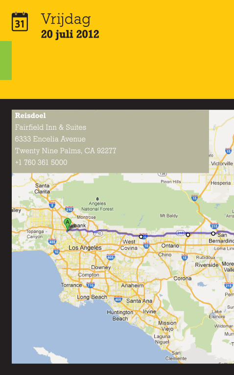
Vrijdag20 juli 2012
Reisdoel
Fairfield Inn & Suites
6333 Encelia Avenue
Twenty Nine Palms, CA 92277
+1 760 361 5000
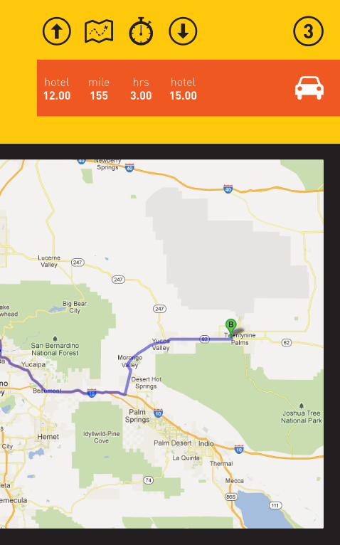
mile155
hotel15.00
hotel12.00
hrs3.00
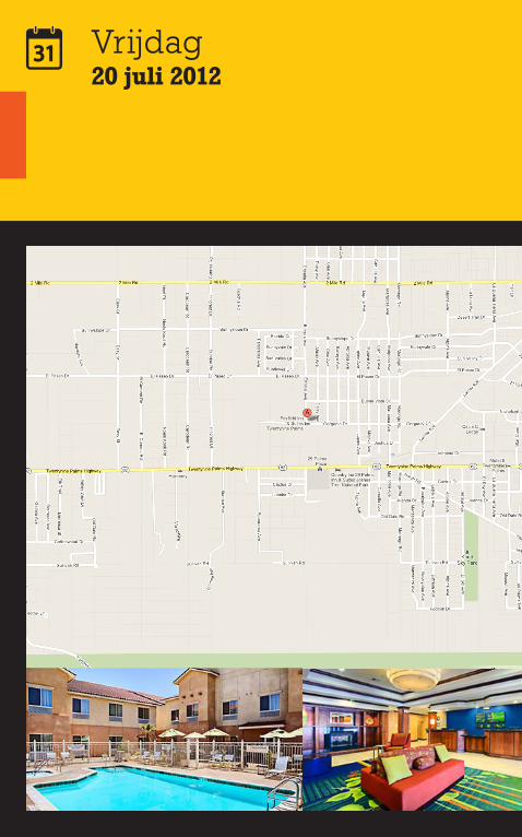
Vrijdag20 juli 2012
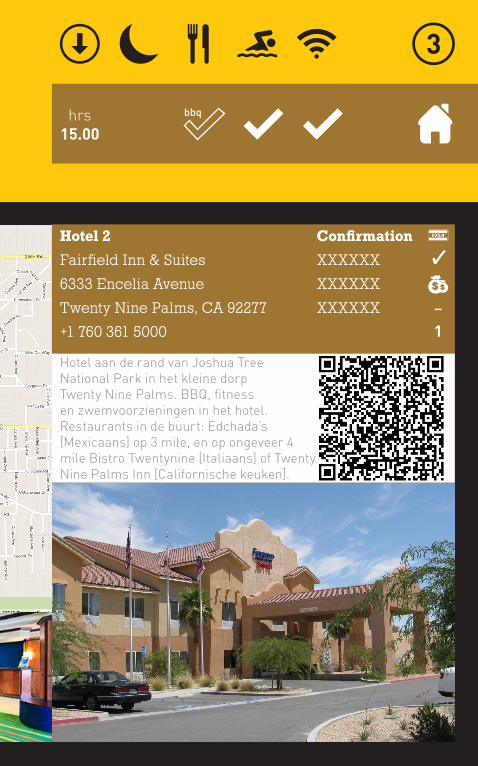
hrs15.00
Hotel 2
Fairfield Inn & Suites
6333 Encelia Avenue
Twenty Nine Palms, CA 92277
+1 760 361 5000
Confirmation
XXXXXX
XXXXXX
XXXXXX
�
1
Hotel aan de rand van Joshua Tree National Park in het kleine dorp Twenty Nine Palms. BBQ, fitness en zwemvoorzieningen in het hotel. Restaurants in de buurt: Edchada’s [Mexicaans] op 3 mile, en op ongeveer 4 mile Bistro Twentynine [Italiaans] of Twenty Nine Palms Inn [Californische keuken].
bbq
Vrijdag20 juli 2012
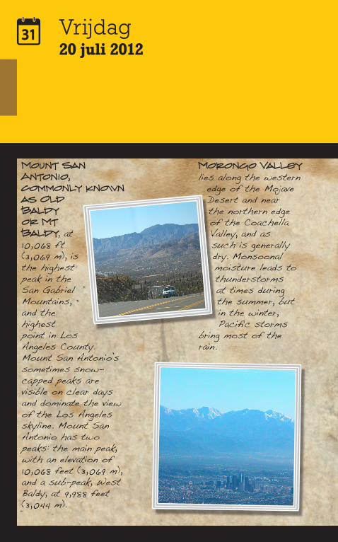
Mount San Antonio, commonly known as Old Baldy or Mt Baldy, at 10,068 ft (3,069 m), is the highest peak in the San Gabriel Mountains, and the highest point in Los Angeles County. Mount San Antonio’s sometimes snow-capped peaks are visible on clear days and dominate the view of the Los Angeles skyline. Mount San Antonio has two peaks: the main peak, with an elevation of 10,068 feet (3,069 m), and a sub-peak, West Baldy, at 9,988 feet (3,044 m).
Morongo Valley lies along the western
edge of the Mojave Desert and near the northern edge of the Coachella Valley, and as such is generally dry. Monsoonal moisture leads to thunderstorms at times during the summer, but in the winter, Pacific storms
bring most of the rain.
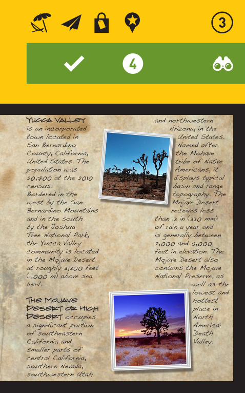
Yucca Valley is an incorporated town located in San Bernardino County, California, United States. The population was 20,700 at the 2010 census. Bordered in the west by the San Bernardino Mountains and in the south by the Joshua Tree National Park, the Yucca Valley community is located in the Mojave Desert at roughly 3,300 feet (1,000 m) above sea level.
The Mojave Desert or High Desert occupies a significant portion of southeastern California and smaller parts of central California, southern Nevada, southwestern Utah
and northwestern Arizona, in the
United States. Named after the Mohave tribe of Native Americans, it displays typical basin and range topography. The Mojave Desert receives less
than 13 in (330 mm) of rain a year and is generally between 2,000 and 5,000 feet in elevation. The Mojave Desert also contains the Mojave National Preserve, as
well as the lowest and hottest place in North America: Death Valley.
Vrijdag20 juli 2012
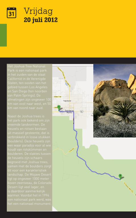
Het Joshua Tree National Park is een nationaal park in het zuiden van de staat Californië in de Verenigde Staten, ten oosten van het gebied tussen Los Angeles en San Diego (ten noorden van Palm Springs). De afmetingen zijn ongeveer 100 km van oost naar west, en 50 km van noord naar zuid.
Naast de Joshua trees is het park ook bekend om zijn vreemde landvormen. De heuvels en rotsen bestaan uit massief gesteente, dat is verbrokkeld in losse stukken (boulders). Deze heuvels zijn een waar paradijs voor al wie houdt van rotsklimmen en boulderen. De vlaktes tussen de heuvels zijn schaars begroeid met Joshua trees, samen met de boulders zorgt dit voor een karakteristiek landschap. De Mojave Desert ligt op ongeveer 1000 meter boven zeeniveau, de Colorado Desert ligt veel lager, en is daardoor aanmerkelijk warmer. Voordat het in 1994 een nationaal park werd, was het een nationaal monument.

Triptip
Joshua Tree National Park
Entree gratis met ParkPas
Openingstijden 08.00 - 17.00 uur [visitor centre]
6554 Park Boulevard, Joshua Tree, CA 92256
Het park wordt gekenmerkt door twee totaal verschillende woestijnlandschappen: de Colorado Desert in het zuidoosten (hier groeien natuurlijke tuinen met onder andere Opuntia en struikgewassen) en de hoger gelegen, vochtigere en iets koelere Mojave Desert. Dit is het gebied waar Joshua trees (Yucca Brevifolia) groeien.
-pp
mile10
hrs4.00
idee07
hrs0.10
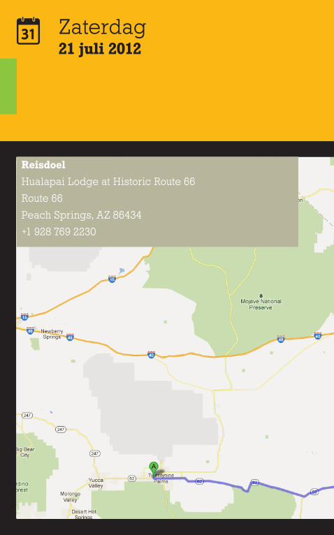
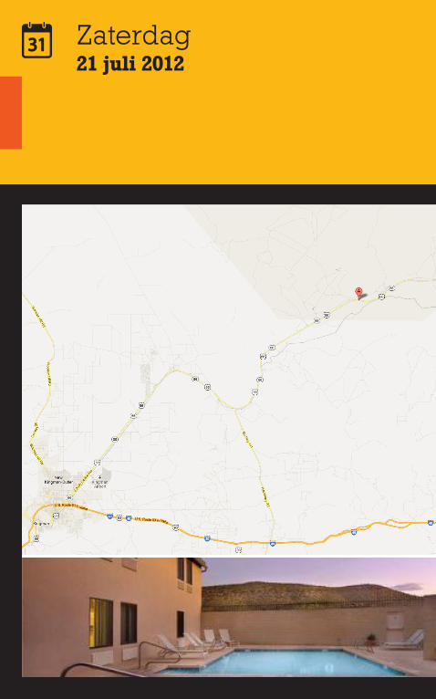
Zaterdag21 juli 2012
Reisdoel
Hualapai Lodge at Historic Route 66
Route 66
Peach Springs, AZ 86434
+1 928 769 2230
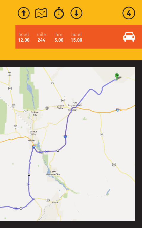
mile244
hotel15.00
hotel12.00
hrs5.00
Zaterdag21 juli 2012
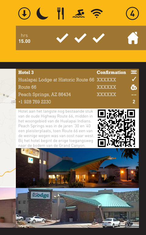
hrs15.00
Hotel 3
Hualapai Lodge at Historic Route 66
Route 66
Peach Springs, AZ 86434
+1 928 769 2230
Confirmation
XXXXXX
XXXXXX
XXXXXX
Hotel aan het langste nog bestaande stuk van de oude Highway Route 66, midden in het woongebied van de Hualapai Indians. Peach Springs was in de jaren ‘30 en ‘40 een pleisterplaats, toen Route 66 een van de weinige wegen was van oost naar west. Bij het hotel begint de enige toegangsweg naar de bodem van de Grand Canyon.
��
2
Zaterdag21 juli 2012
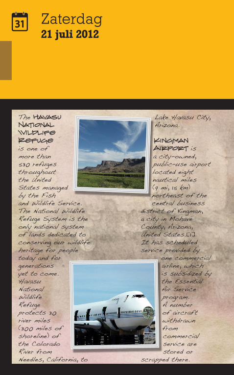
The Havasu National Wildlife Refuge is one of more than 530 refuges throughout the United States managed by the Fish and Wildlife Service. The National Wildlife Refuge System is the only national system of lands dedicated to conserving our wildlife heritage for people today and for generations yet to come. Havasu National Wildlife Refuge protects 30 river miles (300 miles of shoreline) of the Colorado River from Needles, California, to
Lake Havasu City, Arizona.
Kingman Airport is a city-owned, public-use airport located eight nautical miles (9 mi, 15 km) northeast of the central business
district of Kingman, a city in Mohave County, Arizona, United States.[1] It has scheduled service provided by
one commercial airline, which is subsidized by the Essential Air Service program. A number of aircraft withdrawn from commercial service are stored or
scrapped there.
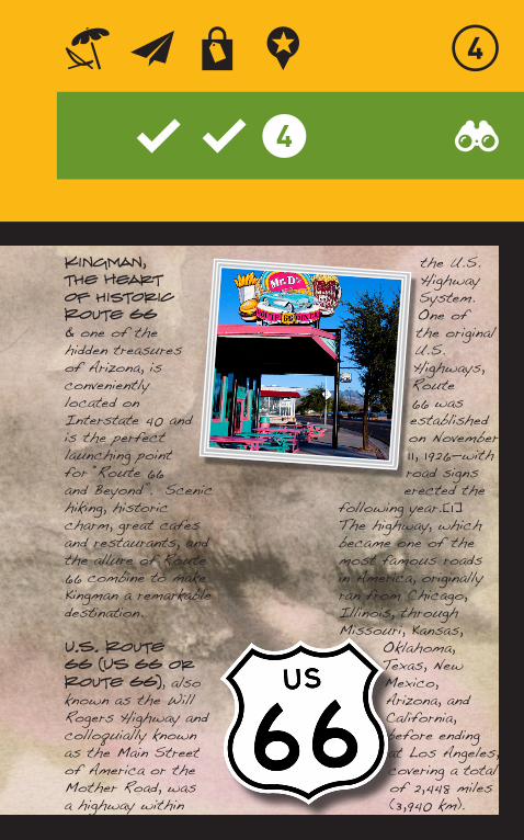
Kingman, the Heart of historic Route 66 & one of the hidden treasures of Arizona, is conveniently located on Interstate 40 and is the perfect launching point for “Route 66 and Beyond”. Scenic hiking, historic charm, great cafes and restaurants, and the allure of Route 66 combine to make Kingman a remarkable destination.
U.S. Route 66 (US 66 or Route 66), also known as the Will Rogers Highway and colloquially known as the Main Street of America or the Mother Road, was a highway within
the U.S. Highway System. One of the original U.S. Highways, Route 66 was established on November 1 1, 1926—with road signs erected the
following year.[1] The highway, which became one of the most famous roads in America, originally ran from Chicago, Illinois, through Missouri, Kansas,
Oklahoma, Texas, New Mexico, Arizona, and California, before ending at Los Angeles, covering a total of 2,448 miles (3,940 km).
Zaterdag21 juli 2012
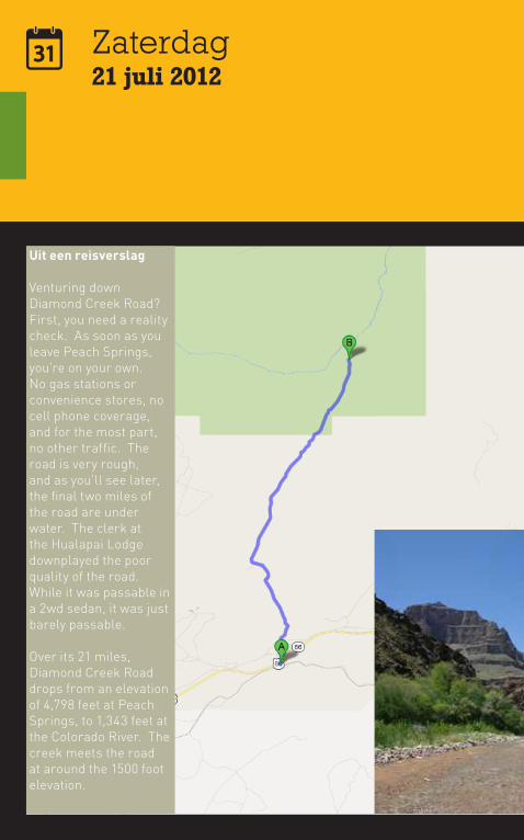
Uit een reisverslag
Venturing down Diamond Creek Road? First, you need a reality check. As soon as you leave Peach Springs, you’re on your own. No gas stations or convenience stores, no cell phone coverage, and for the most part, no other traffic. The road is very rough, and as you’ll see later, the final two miles of the road are under water. The clerk at the Hualapai Lodge downplayed the poor quality of the road. While it was passable in a 2wd sedan, it was just barely passable.
Over its 21 miles, Diamond Creek Road drops from an elevation of 4,798 feet at Peach Springs, to 1,343 feet at the Colorado River. The creek meets the road at around the 1500 foot elevation.
hrs3.00
idee08
mile21
hrs1.30
Triptip
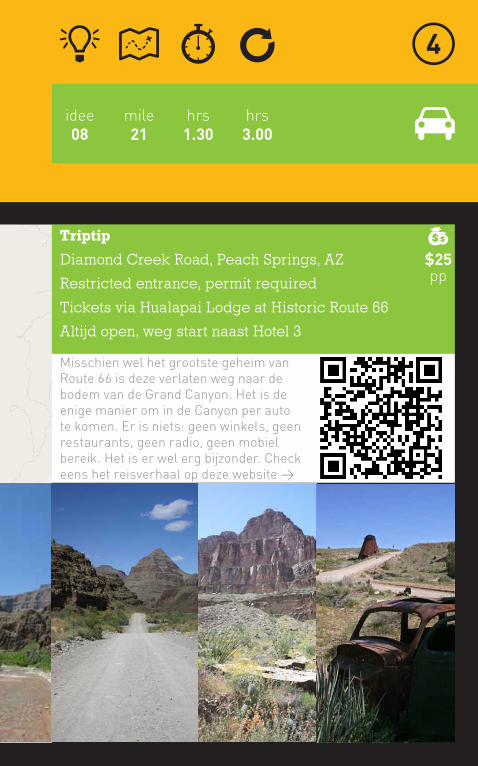
Diamond Creek Road, Peach Springs, AZ
Restricted entrance, permit required
Tickets via Hualapai Lodge at Historic Route 66
Altijd open, weg start naast Hotel 3
Misschien wel het grootste geheim van Route 66 is deze verlaten weg naar de bodem van de Grand Canyon. Het is de enige manier om in de Canyon per auto te komen. Er is niets: geen winkels, geen restaurants, geen radio, geen mobiel bereik. Het is er wel erg bijzonder. Check eens het reisverhaal op deze website >
$25pp
Zondag22 juli 2012
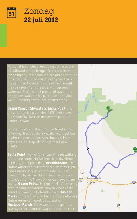
Personal belongings, including cameras are not allowed on the bridge. To protect from dropping any items into the canyon or onto the glass, you will be asked to store your items in the provided lockers. Photos of the Skywalk may be taken from the side with personal cameras. Professional photos of you on the bridge are available for purchase after your walk. Smoking only at designated areas.
Grand Canyon Skywalk at Eagle Point: the glass bridge is suspended 4,000 feet above the Colorado River on the very edge of the Grand Canyon.
What you get with the entrance ticket is the following. Besides the Skywalk, you’ll get lots of photo opportunities with Hualapai Mem-bers. Hop-on-Hop-off shuttle to all view-points.
Eagle Point: Native American Village: walking tour of authentic Native American dwellings depicting multiple tribes. Amphitheater: live Native American performances from multiple tribes demonstrated continuously all dayCreations by Native Hands: featuring hand-made, authentic Native American jewelry and crafts. Guano Point. “Highpoint Hike”: offering breathtaking panoramic canyon views of the Grand Canyon and Colorado River. Hualapai Market: interact with Tribal members offering Native American jewelry and crafts.Hualapai Ranch; Enjoy western hospitality, cowboy entertainment, wagon rides and more.
hrs12.00
idee09
mile116
hrs3.30
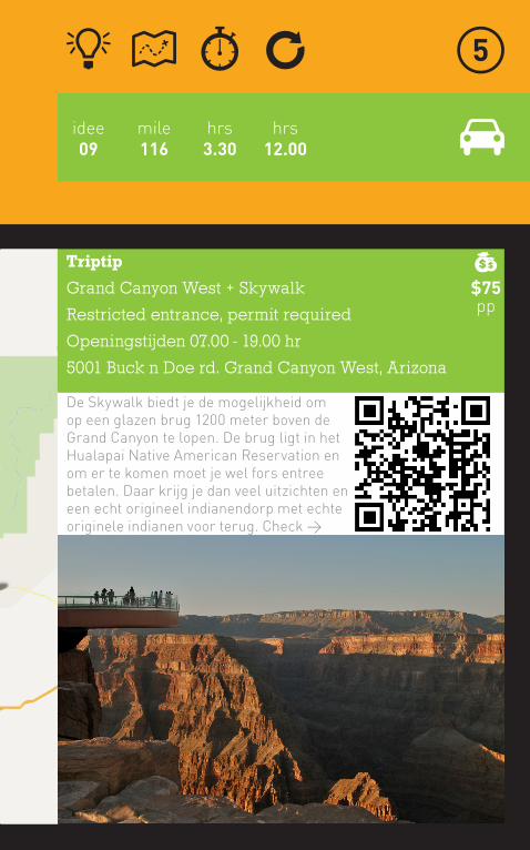
Triptip
Grand Canyon West + Skywalk
Restricted entrance, permit required
Openingstijden 07.00 - 19.00 hr
5001 Buck n Doe rd. Grand Canyon West, Arizona
De Skywalk biedt je de mogelijkheid om op een glazen brug 1200 meter boven de Grand Canyon te lopen. De brug ligt in het Hualapai Native American Reservation en om er te komen moet je wel fors entree betalen. Daar krijg je dan veel uitzichten en een echt origineel indianendorp met echte originele indianen voor terug. Check >
$75pp
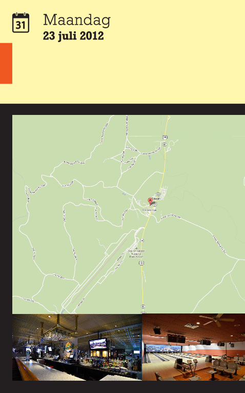
Maandag23 juli 2012
Reisdoel
Best Western Grand Canyon Squire Inn
74 Highway 64
Tusayan, AZ 86023
+1 800 622 6966
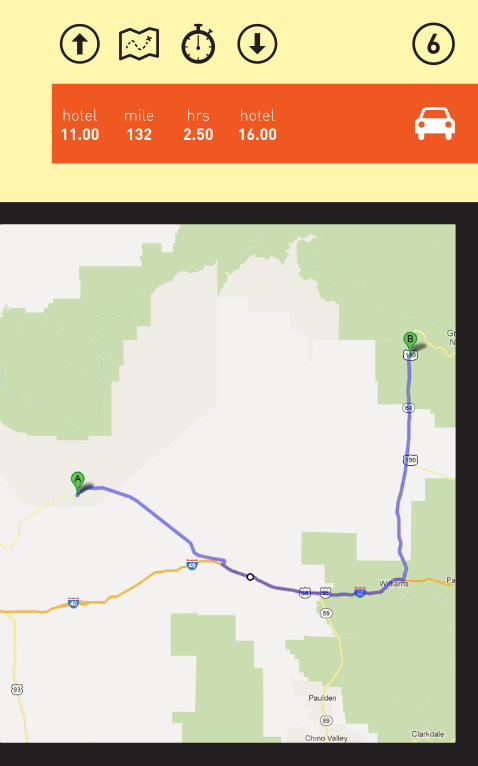
mile132
hotel16.00
hotel11.00
hrs2.50
Maandag23 juli 2012
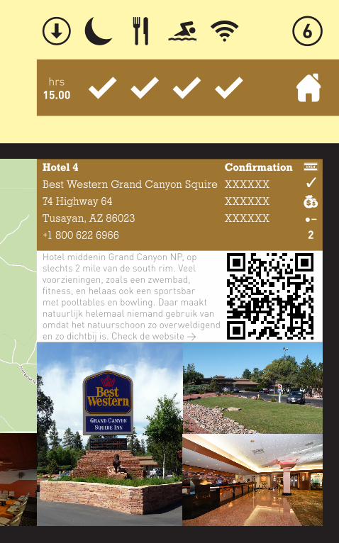
hrs15.00
Hotel 4
Best Western Grand Canyon Squire
74 Highway 64
Tusayan, AZ 86023
+1 800 622 6966
Confirmation
XXXXXX
XXXXXX
XXXXXX
Hotel middenin Grand Canyon NP, op slechts 2 mile van de south rim. Veel voorzieningen, zoals een zwembad, fitness, en helaas ook een sportsbar met pooltables en bowling. Daar maakt natuurlijk helemaal niemand gebruik van omdat het natuurschoon zo overweldigend en zo dichtbij is. Check de website >
��
2
Maandag23 juli 2012
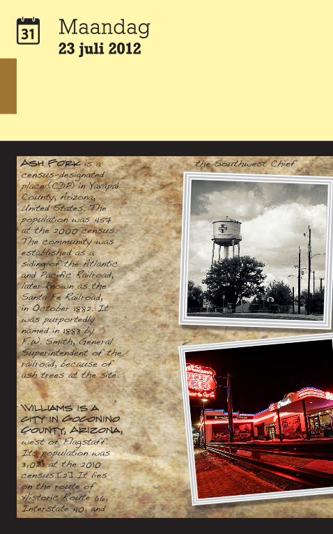
Ash Fork is a census-designated place (CDP) in Yavapai County, Arizona, United States. The population was 457 at the 2000 census. The community was established as a siding of the Atlantic and Pacific Railroad, later known as the Santa Fe Railroad, in October 1882. It was purportedly named in 1883 by F.W. Smith, General Superintendent of the railroad, because of ash trees at the site.
Williams is a city in Coconino County, Arizona, west of Flagstaff. Its population was 3,023 at the 2010 census.[2] It lies on the route of Historic Route 66, Interstate 40, and
the Southwest Chief
Amtrak train route. It is also the southern terminus of the Grand Canyon Railway, which takes visitors to Grand Canyon Village. There are numerous inns, motels, restaurants, gas stations that cater to the large influx of tourists rather than local residents, especially during the summer and holiday seasons. Williams is named after William “Old Bill” Williams, a mountain man and trader who often trapped in the area.
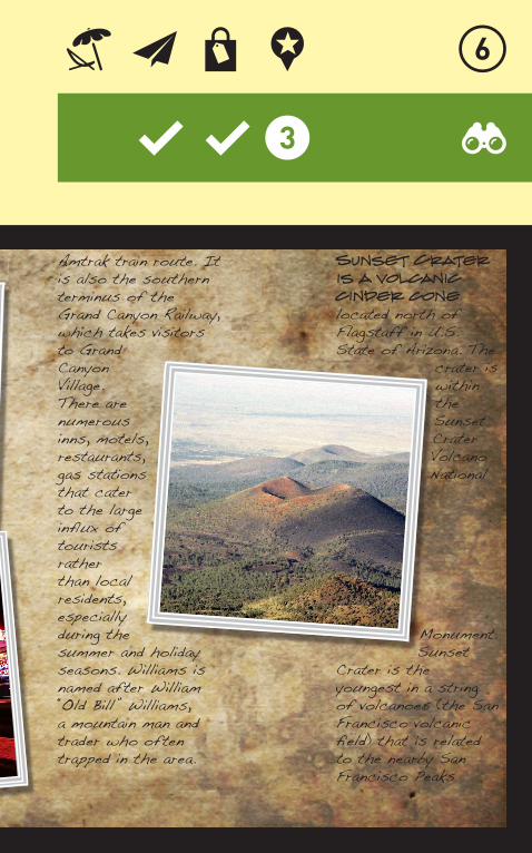
Sunset Crater is a volcanic cinder cone located north of Flagstaff in U.S. State of Arizona. The
crater is within the Sunset Crater Volcano National
Monument.Sunset
Crater is the youngest in a string of volcanoes (the San Francisco volcanic field) that is related to the nearby San Francisco Peaks
Maandag23 juli 2012
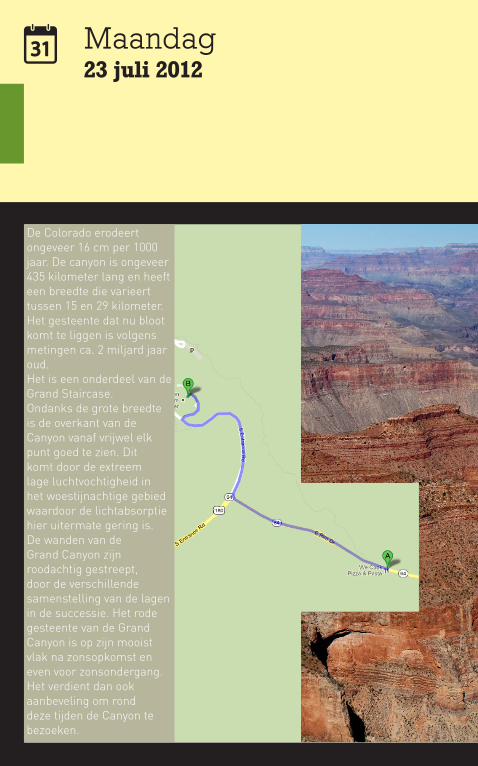
De Colorado erodeert ongeveer 16 cm per 1000 jaar. De canyon is ongeveer 435 kilometer lang en heeft een breedte die varieert tussen 15 en 29 kilometer. Het gesteente dat nu bloot komt te liggen is volgens metingen ca. 2 miljard jaar oud. Het is een onderdeel van de Grand Staircase.Ondanks de grote breedte is de overkant van de Canyon vanaf vrijwel elk punt goed te zien. Dit komt door de extreem lage luchtvochtigheid in het woestijnachtige gebied waardoor de lichtabsorptie hier uitermate gering is.De wanden van de Grand Canyon zijn roodachtig gestreept, door de verschillende samenstelling van de lagen in de successie. Het rode gesteente van de Grand Canyon is op zijn mooist vlak na zonsopkomst en even voor zonsondergang. Het verdient dan ook aanbeveling om rond deze tijden de Canyon te bezoeken.
mile2
hrs0.10
hrs4.00
idee10
Triptip
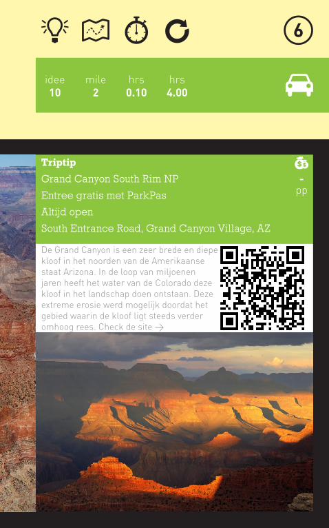
Grand Canyon South Rim NP
Entree gratis met ParkPas
Altijd open
South Entrance Road, Grand Canyon Village, AZ
De Grand Canyon is een zeer brede en diepe kloof in het noorden van de Amerikaanse staat Arizona. In de loop van miljoenen jaren heeft het water van de Colorado deze kloof in het landschap doen ontstaan. Deze extreme erosie werd mogelijk doordat het gebied waarin de kloof ligt steeds verder omhoog rees. Check de site >
-pp
Mather Point
Yavapai Geology Museum
South Kaibab
Trailhead
Yaki Point
Pipe Creek Vista
Grand Canyon
Visitor Center
Grand Canyon
Visitor Center
eastbound
westboundHermits Rest Transfer
Maswik Lodge
Center Road
Village East
Backcountry
Information
CenterMather
Campground
Trailer Village
Grand Canyon Visitor Center
Market Plaza
Westbound
Shrine of the Ages
Train Depot
Bright Angel Lodge
Market Plaza
Eastbound
Shrine of the Ages
eastboundwestboundHermits
RestVillage Route Transfer
Trailview Overlook
Maricopa Point
Hopi Point
Powell Point
Mohave Point
The Abyss
Pima Point
Pima Point
Mohave Point
Powell PointMonument
Creek Vista
eastbound
westbound Grand Canyon Visitor Center
Best Western
Grand Canyon
Squire Inn
Western
Discovery
Museum
IMAX/R.P.’s
Grand Canyon Airport northbound
southbound
Grand
Hotel
0.5 Mile
0 0.5 Kilometer
0
North
Village Route and bus stopKaibab/Rim Route and bus stop
LEGEND
Paved Rim Trail
Paved Greenway TrailShuttle bus gate
Hermits Rest Route and bus stop
Tusayan Route and bus stop
Drivable park roads Drinking water
Picnic area
Parking
First aid
Books and souvenirs
Unpaved Rim Trail
Unpaved Greenway TrailTelephone
Information
Restrooms
Theater
See Page 6See Page 6
64
1
4
2
3
Mather Point7120 ft2170 m
Bright Angel Bicycles& Grab ‘n Go Cafe (opens June)
Commercial Vehicle Parking Only
Mather Amphitheater
Grand Canyon Visitor Center
Books & More8 am–8 pm
Grand Canyon Visitor Center
HermitTrailhead
Verka
mp’s
Visito
r Cen
ter
Clinic
Albright Training Center
Hermits Rest Snack Bar 8am to sunsetHermits Rest Gift Shop 8am to sunset
Hermit Road Shuttle buses only.
Yaki Point Road Shuttle buses only.
64
64
Desert View
25mi (40 km
)
Tusayan 7mi (11km)
0.8mi (1.3km)
0.9mi (1.4km)
0.5mi (0.8km
)
1.1mi (1.8km
)
1.7mi (2.7km
)
0.9mi (1.4km)
1.1m
i (1.
8km
)
0.8mi (1.3km
)
0.3mi (0.5km)
0.5mi (0.8km)
0.7mi (1.1km
)
0.7mi (1.1km
)
1.2mi (1.9km)
0.7mi (1.1km)
0.7m
i (1.
1km
)
0.8mi (1.3km)
0.4mi (0.6km)0.8mi (1.3km)
0.4mi (0.6km)
0.7mi (1.1km)
Trai
l o
f Ti
me
*
***
***
****
**
*******
*** * ******
**** *
****
*
*
**
**
*Her
mits
Res
t Route
Tran
sfer
CenterRoad
Shrine ofthe Ages
Mather Campground
TrailerVillage
Market PlazaEastbound
Mar
ket P
laza W
estb
ound
Bright A
ngel Lo
dge
VillageEast
MaswikLodge
Backcountry Information Center
Train
Dep
ot
Mather Point
Pipe Creek Vista
South KaibabTrailhead
Yaki Point
Yavapai Point and Geology Museum
Hermits Rest
Pima Point
MonumentCreek Vista
The Abyss
Mohave Point
Hopi Point
Powell Point
Maricopa Point
Trailview Overlook
Village Route TransferA
B
RV Parking
C
D
Bright Angel Trailhead Parking under construction. Plan to park at Grand Canyon Visitor Center and ride the free Village Route shuttle bus to Grand Canyon Village.
Center Road
Desert View Drive
South Entrance Road
Zuni
Way
Market
Pla
za R
oad
one way
Explore in Your CarYou can drive anywhere there is a solid black line on the map above. You cannot drive the Hermit Road or Yaki Point Road; free shuttle buses operate in these areas. If you would like to explore more of the park by vehicle, consider driving to Desert View (see page 8).
All parking lots in Grand Canyon Village are located near free shuttle bus stops. Parking lots 1–4 are at Grand Canyon Visitor Center. Lot 1 includes auto, RV, and trailer parking.
Parking lots A (Park Headquarters) and B (Market Plaza) are large and may have empty spaces. Parking lot C (near Center Road in Grand Canyon Village) is small; lot D (Backcountry Information Center) offers auto parking in the north end and RV and trailer parking in the south end.
Do not park along the roadside, except where signs or lines on the road indicate it is permissible.
Ride the Free Shuttle Buses Reducing air pollution and taking nearly a half-million vehicles off park roads each year, shuttle buses offer a hassle-free transportation option.
Wander the Rim TrailThe Rim Trail offers a diverse hiking experience along 13 miles (21 km) of the canyon, shown by brown dashed lines on the map above. From a short 30-minute sunrise walk to a full afternoon hike, choose your adventure. The Rim Trail is wheelchair accessible from Lookout Studio to South Kaibab Trailhead. Distances and times are one way.
EASY, POPuLAR HIKES
Wide, paved trail; accessible by strollers and wheelchairs with assistanceVillage Historic DistrictVerkamp’s Visitor Center to Kolb StudioExplore local history.0.6 miles (1 km), 20–30 minutes
Trail of TimeYavapai Geology Museum to Verkamp’s Visitor Center See and touch canyon rocks.1.3 miles (2.1 km), 1–2 hours
Yavapai Point to Mather PointViews of Colorado River and Phantom Ranch0.7 miles (1.1 km), 30–45 minutes
EASY, LESS-TRAVELED HIKES
Little elevation gainSouth Kaibab Trailhead to Mather Point Great views of an inner-canyon trail2.1 miles (3.4 km), 1.5–2 hours
Monument Creek Vista to Hermits RestAccessible by bicycle or on foot2.8 miles (4.5 km), 2–2.5 hours
Hopi Point to Powell PointDynamic views of the canyon; unpaved0.3 miles (0.5 km), 30–45 minutes
MODERATE HIKES
Some elevation gain and/or rough, narrow trailMohave Point to Monument Creek VistaUnpaved trail with great views2.0 miles (3.2 km), 1.5–2 hours
Hermits Rest Route Transfer toTrailview OverlookPaved, steep grade, overlooks Grand Canyon Village and Bright Angel Trail0.7 miles (1.1 km), 20–30 minutes
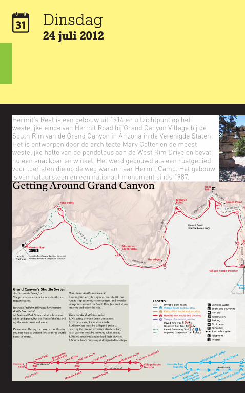
HERMIT REST ROuTE—RED On MAP ABOVE
Without getting off the bus, this 7-mile (11 km) route takes 80 minutes round-trip. Shuttles stop at nine overlooks westbound, but only Pima, Mohave, and Powell points going east from Hermits Rest.
May buses run every:30 minutes 4:30 am–7:30 am15 minutes 7:30 am to sunset30 minutes sunset to one hour after sunset
June, July, and August buses run every:30 minutes 4:15 am–7:30 am15 minutes 7:30 am to sunset30 minutes sunset to one hour after sunset
September buses run every:30 minutes 5:15 am–7:30 am15 minutes 7:30 am to sunset30 minutes sunset to one hour after sunset
VILLAGE ROuTE—BLuE On MAP ABOVE
This 50-minute round-trip route provides transportation between Grand Canyon Visitor Center, hotels, restaurants, and campgrounds. Scenic canyon views are a short walk from some stops.
May buses run every:30 minutes 4:30 am–6:30 am15 minutes 6:30 am–7:30 pm30 minutes 7:30 pm–10 pm
June, July, and August buses run every:30 minutes 4:15 am–6:30 am15 minutes 6:30 am–9 pm30 minutes 9 pm–11 pm
September buses run every:30 minutes 5:15 am–6:30 am15 minutes 6:30 am–7:30 pm30 minutes 7:30 pm–10 pm
KAIBAB/RIM ROuTE—ORAnGE On MAP ABOVE
This 50-minute round-trip route stops at five viewpoints and Grand Canyon Visitor Center. This route and the morning Hiker’s Express shuttle bus offer the only access to South Kaibab Trailhead.
May buses run every:30 minutes 4:30 am–6:30 am15 minutes 6:30 am to one hour after sunset
June, July, and August buses run every:30 minutes 4:15 am–6:30 am15 minutes 6:30 am to one hour after sunset.
September buses run every:30 minutes 5:15 am–6:30 am15 minutes 6:30 am to one hour after sunset
TuSAYAn ROuTE—PuRPLE On THE MAP ABOVE
Buses provide transportation between Tusayan, Arizona, and Grand Canyon Visitor Center. You must have a park entrance permit to use this shuttle. Buses run every 15 minutes and the ride takes 20 minutes each way.
First bus leaves Tusayan at 8 am from IMAX.First bus leaves Grand Canyon Visitor Center at 8:40 am.Last buses leave from both areas at 9:30 pm.
HIKER’S EXPRESS
Service to South Kaibab Trailhead. Bus begins at Bright Angel Lodge, then stops at Backcountry Information Center, Grand Canyon Visitor Center, and South Kaibab Trailhead. Bus leaves Bright Angel Lodge at:
5 am, 6 am, 7 am in May and September 4 am, 5 am, 6 am in June, July, and August
ACCESSIBILITY
Buses are equipped with ramps to carry passengers in wheelchairs smaller than 30 inches wide by 48 inches long (76 by 122 cm). Most motorized scooters will not fit on buses.
The Scenic Drive Accessibility Permit allows visitors with mobility issues entry to some areas closed to public traffic. The permit is available at entrance gates, visitor centers, and hotel lobbies.
Getting Around Grand Canyon
Pedal the Greenway Trail Explore the Greenway Trail on a bicycle; follow the green dashed lines on the map above. Travel along the canyon rim and through ponderosa pine forests.
Bicycles are also permitted on all paved and some unpaved roads open to the public.Bicycles are prohibited on the Rim Trail and inner-canyon trails. Bicyclists must obey all traffic regulations. Ride single file with the flow of traffic and wear bright colors and a helmet. On Hermit Road, bicyclists must pull to the right shoulder and dismount when buses are attempting to pass.
Bright Angel Bicycles Bicycle rentals and guided tours; located at Grand Canyon Visitor Center. 928-814-8704 or www.bikegrandcanyon.com
Grand Canyon’s Shuttle SystemAre the shuttle buses free?Yes, park entrance fees include shuttle bus transportation.
How can I tell the difference between the shuttle bus routes?All National Park Service shuttle buses are white and green, but the front of the bus will say the route color and name.
Please note: During the busy part of the day, you may have to wait for two or three shuttle buses to board.
How do the shuttle buses work?Running like a city bus system, four shuttle bus routes stop at shops, visitor centers, and popular viewpoints around the South Rim. Just wait at any bus stop and enjoy the ride.
What are the shuttle bus rules?1. No eating or open drink containers.2. No pets, except service animals.3. All strollers must be collapsed prior to entering the bus; no oversized strollers. Baby back carriers must be removed when seated.4. Riders must load and unload their bicycles.5. Shuttle buses only stop at designated bus stops.
The Guide • Summer 54 Grand Canyon National Park • South Rim
Dinsdag24 juli 2012
Hermit’s Rest is een gebouw uit 1914 en uitzichtpunt op het westelijke einde van Hermit Road bij Grand Canyon Village bij de South Rim van de Grand Canyon in Arizona in de Verenigde Staten. Het is ontworpen door de architecte Mary Colter en de meest westelijke halte van de pendelbus aan de West Rim Drive en bevat nu een snackbar en winkel. Het werd gebouwd als een rustgebied voor toeristen die op de weg waren naar Hermit Camp. Het gebouw is van natuursteen en een nationaal monument sinds 1987.

Mather Point
Yavapai Geology Museum
South Kaibab
Trailhead
Yaki Point
Pipe Creek Vista
Grand Canyon
Visitor Center
Grand Canyon
Visitor Center
eastbound
westboundHermits Rest Transfer
Maswik Lodge
Center Road
Village East
Backcountry
Information
CenterMather
Campground
Trailer Village
Grand Canyon Visitor Center
Market Plaza
Westbound
Shrine of the Ages
Train Depot
Bright Angel Lodge
Market Plaza
Eastbound
Shrine of the Ages
eastboundwestboundHermits
RestVillage Route Transfer
Trailview Overlook
Maricopa Point
Hopi Point
Powell Point
Mohave Point
The Abyss
Pima Point
Pima Point
Mohave Point
Powell PointMonument
Creek Vista
eastbound
westbound Grand Canyon Visitor Center
Best Western
Grand Canyon
Squire Inn
Western
Discovery
Museum
IMAX/R.P.’s
Grand Canyon Airport northbound
southbound
Grand
Hotel
0.5 Mile
0 0.5 Kilometer
0
North
Village Route and bus stopKaibab/Rim Route and bus stop
LEGEND
Paved Rim Trail
Paved Greenway TrailShuttle bus gate
Hermits Rest Route and bus stop
Tusayan Route and bus stop
Drivable park roads Drinking water
Picnic area
Parking
First aid
Books and souvenirs
Unpaved Rim Trail
Unpaved Greenway TrailTelephone
Information
Restrooms
Theater
See Page 6See Page 6
64
1
4
2
3
Mather Point7120 ft2170 m
Bright Angel Bicycles& Grab ‘n Go Cafe (opens June)
Commercial Vehicle Parking Only
Mather Amphitheater
Grand Canyon Visitor Center
Books & More8 am–8 pm
Grand Canyon Visitor Center
HermitTrailhead
Verka
mp’s
Visito
r Cen
ter
Clinic
Albright Training Center
Hermits Rest Snack Bar 8am to sunsetHermits Rest Gift Shop 8am to sunset
Hermit Road Shuttle buses only.
Yaki Point Road Shuttle buses only.
64
64
Desert View
25mi (40 km
)
Tusayan 7mi (11km)
0.8mi (1.3km)
0.9mi (1.4km)
0.5mi (0.8km
)
1.1mi (1.8km
)
1.7mi (2.7km
)
0.9mi (1.4km)
1.1m
i (1.
8km
)
0.8mi (1.3km
)
0.3mi (0.5km)
0.5mi (0.8km)
0.7mi (1.1km
)
0.7mi (1.1km
)
1.2mi (1.9km)
0.7mi (1.1km)
0.7m
i (1.
1km
)
0.8mi (1.3km)
0.4mi (0.6km)0.8mi (1.3km)
0.4mi (0.6km)
0.7mi (1.1km)
Trai
l o
f Ti
me
*
***
***
****
**
*******
*** * ******
**** *
****
*
*
**
**
*Her
mits
Res
t Route
Tran
sfer
CenterRoad
Shrine ofthe Ages
Mather Campground
TrailerVillage
Market PlazaEastbound
Mar
ket P
laza W
estb
ound
Bright A
ngel Lo
dge
VillageEast
MaswikLodge
Backcountry Information Center
Train
Dep
ot
Mather Point
Pipe Creek Vista
South KaibabTrailhead
Yaki Point
Yavapai Point and Geology Museum
Hermits Rest
Pima Point
MonumentCreek Vista
The Abyss
Mohave Point
Hopi Point
Powell Point
Maricopa Point
Trailview Overlook
Village Route TransferA
B
RV Parking
C
D
Bright Angel Trailhead Parking under construction. Plan to park at Grand Canyon Visitor Center and ride the free Village Route shuttle bus to Grand Canyon Village.
Center Road
Desert View Drive
South Entrance Road
Zuni
Way
Market
Pla
za R
oad
one way
Explore in Your CarYou can drive anywhere there is a solid black line on the map above. You cannot drive the Hermit Road or Yaki Point Road; free shuttle buses operate in these areas. If you would like to explore more of the park by vehicle, consider driving to Desert View (see page 8).
All parking lots in Grand Canyon Village are located near free shuttle bus stops. Parking lots 1–4 are at Grand Canyon Visitor Center. Lot 1 includes auto, RV, and trailer parking.
Parking lots A (Park Headquarters) and B (Market Plaza) are large and may have empty spaces. Parking lot C (near Center Road in Grand Canyon Village) is small; lot D (Backcountry Information Center) offers auto parking in the north end and RV and trailer parking in the south end.
Do not park along the roadside, except where signs or lines on the road indicate it is permissible.
Ride the Free Shuttle Buses Reducing air pollution and taking nearly a half-million vehicles off park roads each year, shuttle buses offer a hassle-free transportation option.
Wander the Rim TrailThe Rim Trail offers a diverse hiking experience along 13 miles (21 km) of the canyon, shown by brown dashed lines on the map above. From a short 30-minute sunrise walk to a full afternoon hike, choose your adventure. The Rim Trail is wheelchair accessible from Lookout Studio to South Kaibab Trailhead. Distances and times are one way.
EASY, POPuLAR HIKES
Wide, paved trail; accessible by strollers and wheelchairs with assistanceVillage Historic DistrictVerkamp’s Visitor Center to Kolb StudioExplore local history.0.6 miles (1 km), 20–30 minutes
Trail of TimeYavapai Geology Museum to Verkamp’s Visitor Center See and touch canyon rocks.1.3 miles (2.1 km), 1–2 hours
Yavapai Point to Mather PointViews of Colorado River and Phantom Ranch0.7 miles (1.1 km), 30–45 minutes
EASY, LESS-TRAVELED HIKES
Little elevation gainSouth Kaibab Trailhead to Mather Point Great views of an inner-canyon trail2.1 miles (3.4 km), 1.5–2 hours
Monument Creek Vista to Hermits RestAccessible by bicycle or on foot2.8 miles (4.5 km), 2–2.5 hours
Hopi Point to Powell PointDynamic views of the canyon; unpaved0.3 miles (0.5 km), 30–45 minutes
MODERATE HIKES
Some elevation gain and/or rough, narrow trailMohave Point to Monument Creek VistaUnpaved trail with great views2.0 miles (3.2 km), 1.5–2 hours
Hermits Rest Route Transfer toTrailview OverlookPaved, steep grade, overlooks Grand Canyon Village and Bright Angel Trail0.7 miles (1.1 km), 20–30 minutes
HERMIT REST ROuTE—RED On MAP ABOVE
Without getting off the bus, this 7-mile (11 km) route takes 80 minutes round-trip. Shuttles stop at nine overlooks westbound, but only Pima, Mohave, and Powell points going east from Hermits Rest.
May buses run every:30 minutes 4:30 am–7:30 am15 minutes 7:30 am to sunset30 minutes sunset to one hour after sunset
June, July, and August buses run every:30 minutes 4:15 am–7:30 am15 minutes 7:30 am to sunset30 minutes sunset to one hour after sunset
September buses run every:30 minutes 5:15 am–7:30 am15 minutes 7:30 am to sunset30 minutes sunset to one hour after sunset
VILLAGE ROuTE—BLuE On MAP ABOVE
This 50-minute round-trip route provides transportation between Grand Canyon Visitor Center, hotels, restaurants, and campgrounds. Scenic canyon views are a short walk from some stops.
May buses run every:30 minutes 4:30 am–6:30 am15 minutes 6:30 am–7:30 pm30 minutes 7:30 pm–10 pm
June, July, and August buses run every:30 minutes 4:15 am–6:30 am15 minutes 6:30 am–9 pm30 minutes 9 pm–11 pm
September buses run every:30 minutes 5:15 am–6:30 am15 minutes 6:30 am–7:30 pm30 minutes 7:30 pm–10 pm
KAIBAB/RIM ROuTE—ORAnGE On MAP ABOVE
This 50-minute round-trip route stops at five viewpoints and Grand Canyon Visitor Center. This route and the morning Hiker’s Express shuttle bus offer the only access to South Kaibab Trailhead.
May buses run every:30 minutes 4:30 am–6:30 am15 minutes 6:30 am to one hour after sunset
June, July, and August buses run every:30 minutes 4:15 am–6:30 am15 minutes 6:30 am to one hour after sunset.
September buses run every:30 minutes 5:15 am–6:30 am15 minutes 6:30 am to one hour after sunset
TuSAYAn ROuTE—PuRPLE On THE MAP ABOVE
Buses provide transportation between Tusayan, Arizona, and Grand Canyon Visitor Center. You must have a park entrance permit to use this shuttle. Buses run every 15 minutes and the ride takes 20 minutes each way.
First bus leaves Tusayan at 8 am from IMAX.First bus leaves Grand Canyon Visitor Center at 8:40 am.Last buses leave from both areas at 9:30 pm.
HIKER’S EXPRESS
Service to South Kaibab Trailhead. Bus begins at Bright Angel Lodge, then stops at Backcountry Information Center, Grand Canyon Visitor Center, and South Kaibab Trailhead. Bus leaves Bright Angel Lodge at:
5 am, 6 am, 7 am in May and September 4 am, 5 am, 6 am in June, July, and August
ACCESSIBILITY
Buses are equipped with ramps to carry passengers in wheelchairs smaller than 30 inches wide by 48 inches long (76 by 122 cm). Most motorized scooters will not fit on buses.
The Scenic Drive Accessibility Permit allows visitors with mobility issues entry to some areas closed to public traffic. The permit is available at entrance gates, visitor centers, and hotel lobbies.
Getting Around Grand Canyon
Pedal the Greenway Trail Explore the Greenway Trail on a bicycle; follow the green dashed lines on the map above. Travel along the canyon rim and through ponderosa pine forests.
Bicycles are also permitted on all paved and some unpaved roads open to the public.Bicycles are prohibited on the Rim Trail and inner-canyon trails. Bicyclists must obey all traffic regulations. Ride single file with the flow of traffic and wear bright colors and a helmet. On Hermit Road, bicyclists must pull to the right shoulder and dismount when buses are attempting to pass.
Bright Angel Bicycles Bicycle rentals and guided tours; located at Grand Canyon Visitor Center. 928-814-8704 or www.bikegrandcanyon.com
Grand Canyon’s Shuttle SystemAre the shuttle buses free?Yes, park entrance fees include shuttle bus transportation.
How can I tell the difference between the shuttle bus routes?All National Park Service shuttle buses are white and green, but the front of the bus will say the route color and name.
Please note: During the busy part of the day, you may have to wait for two or three shuttle buses to board.
How do the shuttle buses work?Running like a city bus system, four shuttle bus routes stop at shops, visitor centers, and popular viewpoints around the South Rim. Just wait at any bus stop and enjoy the ride.
What are the shuttle bus rules?1. No eating or open drink containers.2. No pets, except service animals.3. All strollers must be collapsed prior to entering the bus; no oversized strollers. Baby back carriers must be removed when seated.4. Riders must load and unload their bicycles.5. Shuttle buses only stop at designated bus stops.
The Guide • Summer 54 Grand Canyon National Park • South Rim
mile10
hrs1.00
hrs3.00
idee11
Triptip
Hermits Rest at Grand Canyon South Rim NP
Entree gratis met ParkPas, incl shuttle
Openingstijden 04.15 - 23.00 uur [shuttles]
Start looproute naar Colorado rivier
-pp
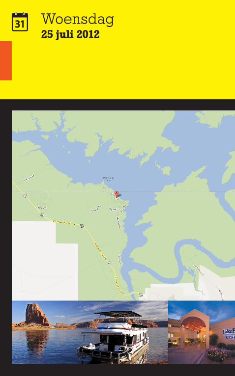
Woensdag25 juli 2012
Reisdoel
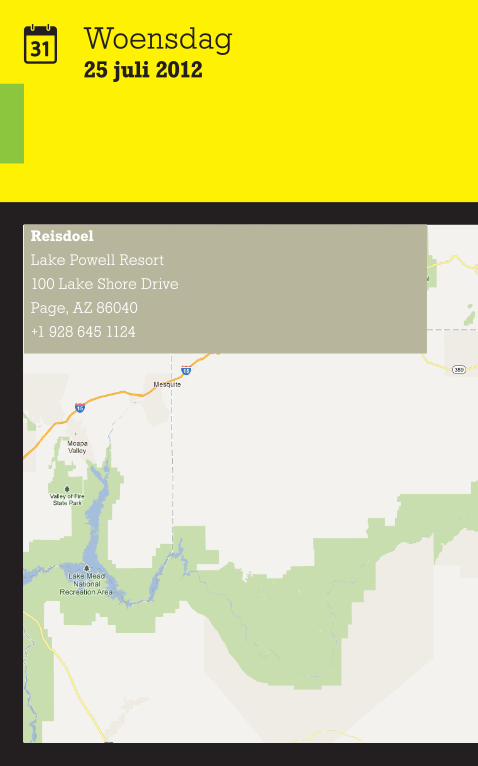
Lake Powell Resort
100 Lake Shore Drive
Page, AZ 86040
+1 928 645 1124
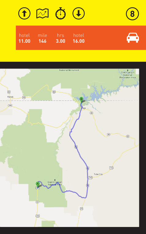
mile146
hotel16.00
hotel11.00
hrs3.00
Woensdag25 juli 2012
hrs15.00
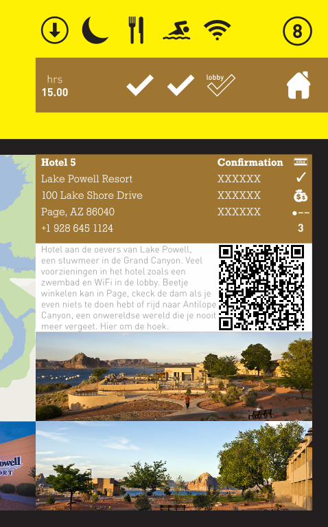
Hotel 5
Lake Powell Resort
100 Lake Shore Drive
Page, AZ 86040
+1 928 645 1124
Confirmation
XXXXXX
XXXXXX
XXXXXX
Hotel aan de oevers van Lake Powell, een stuwmeer in de Grand Canyon. Veel voorzieningen in het hotel zoals een zwembad en WiFi in de lobby. Beetje winkelen kan in Page, ckeck de dam als je even niets te doen hebt of rijd naar Antilope Canyon, een onwereldse wereld die je nooit meer vergeet. Hier om de hoek.
���
3
lobby
Woensdag25 juli 2012
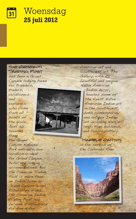
the Cameron Trading Post has been a Grand Canyon lodging haven for travelers, traders, vacationers and explorers who come from all points of the globe. Just 30 minutes from the Grand Canyon National Park entrance, our location is ideal for Grand Canyon hotel and lodging accomodations. But the Cameron Trading Post is more than an Indian lodge or Grand Canyon hotel. Established in 1916, the Cameron Indian Trading Post has become a showplace for fine Native
American art and Southwest art. The Gallery, with its beautiful and unique Native American
Indian decor, houses some of the finest Native American Indian art in the Southwest, both contemporary and antique Indian art including Nava jo rugs, Hopi kachinas, and Pueblo pottery.
Marble Canyon is the section of the Colorado River
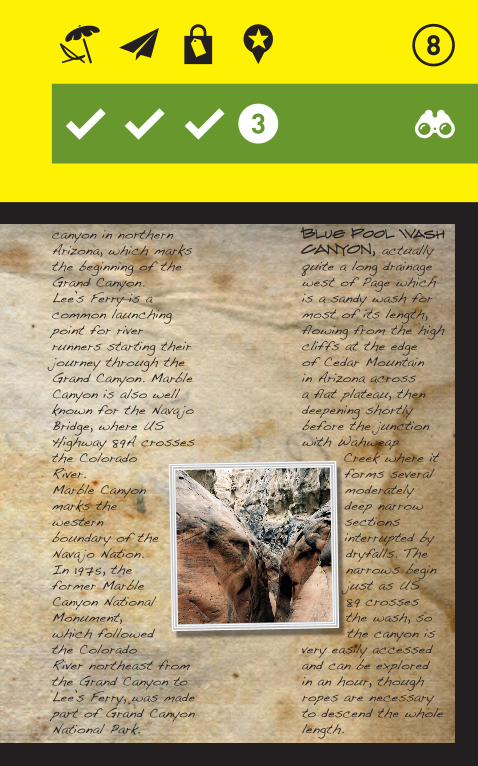
canyon in northern Arizona, which marks the beginning of the Grand Canyon.Lee’s Ferry is a common launching point for river runners starting their journey through the Grand Canyon. Marble Canyon is also well known for the Nava jo Bridge, where US Highway 89A crosses the Colorado River.Marble Canyon marks the western boundary of the Nava jo Nation. In 1975, the former Marble Canyon National Monument, which followed the Colorado River northeast from the Grand Canyon to Lee’s Ferry, was made part of Grand Canyon National Park.
Blue Pool Wash CANYON, actually quite a long drainage west of Page which is a sandy wash for most of its length, flowing from the high cliffs at the edge of Cedar Mountain in Arizona across a flat plateau, then deepening shortly before the junction with Wahweap
Creek where it forms several moderately deep narrow sections interrupted by dryfalls. The narrows begin just as US 89 crosses the wash, so the canyon is
very easily accessed and can be explored in an hour, though ropes are necessary to descend the whole length.
Donderdag26 juli 2012
hrs13.00
mile30
hrs2.30
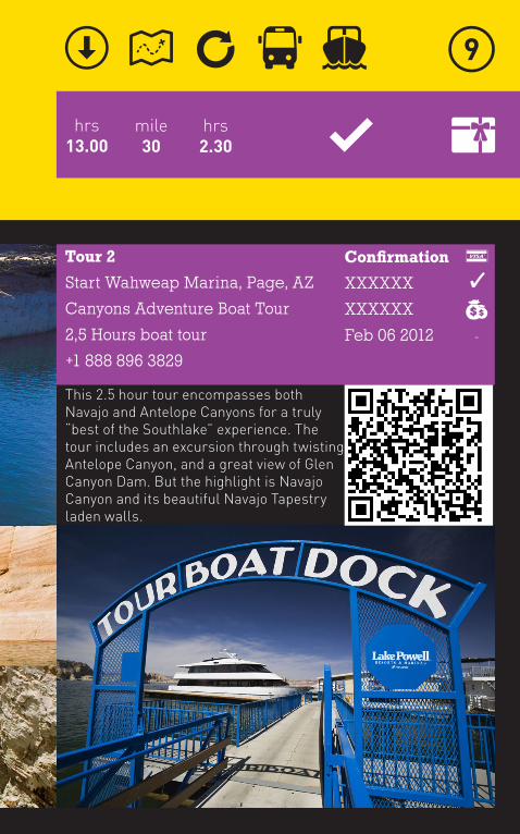
Tour 2
Start Wahweap Marina, Page, AZ
Canyons Adventure Boat Tour
2,5 Hours boat tour
+1 888 896 3829
Confirmation
XXXXXX
XXXXXX
Feb 06 2012
-
This 2.5 hour tour encompasses both Navajo and Antelope Canyons for a truly “best of the Southlake” experience. The tour includes an excursion through twisting Antelope Canyon, and a great view of Glen Canyon Dam. But the highlight is Navajo Canyon and its beautiful Navajo Tapestry laden walls.
Donderdag26 juli 2012
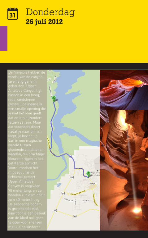
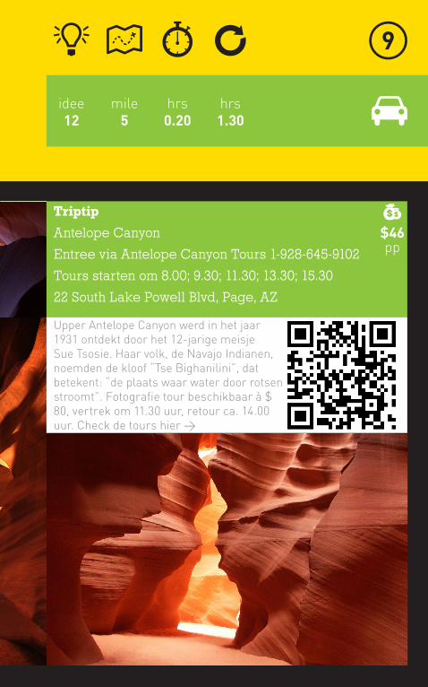
De Navajo’s hebben de vondst van de canyon jarenlang geheim gehouden. Upper Antelope Canyon ligt binnen in een hoog, rood zandstenen plateau; de ingang is een smalle opening die je niet het idee geeft dat er iets bijzonders te zien zal zijn. Maar dat verandert direct nadat je naar binnen loopt, je bevindt je dan in een magische wereld tussen glooiende zandstenen wanden, die prachtige kleuren krijgen in het gefilterde zonlicht. Vooral rondom het middaguur is de lichtinval perfect.Upper Antelope Canyon is ongeveer 90 meter lang, en de wanden zijn gemiddeld zo’n 40 meter hoog. De zanderige bodem is grotendeels vlak, daardoor is een bezoek aan de kloof ook goed te doen voor mensen met kleine kinderen.
mile5
hrs0.20
hrs1.30
idee12
Triptip
Antelope Canyon
Entree via Antelope Canyon Tours 1-928-645-9102
Tours starten om 8.00; 9.30; 11.30; 13.30; 15.30
22 South Lake Powell Blvd, Page, AZ
Upper Antelope Canyon werd in het jaar 1931 ontdekt door het 12-jarige meisje Sue Tsosie. Haar volk, de Navajo Indianen, noemden de kloof “Tse Bighanilini”, dat betekent: “de plaats waar water door rotsen stroomt”. Fotografie tour beschikbaar à $ 80, vertrek om 11.30 uur, retour ca. 14.00 uur. Check de tours hier >
$46pp
Donderdag26 juli 2012
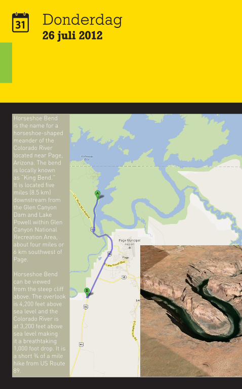
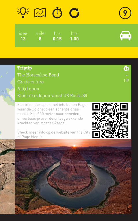
Horseshoe Bend is the name for a horseshoe-shaped meander of the Colorado River located near Page, Arizona. The bend is locally known as “King Bend.” It is located five miles (8.5 km) downstream from the Glen Canyon Dam and Lake Powell within Glen Canyon National Recreation Area, about four miles or 6 km southwest of Page.
Horseshoe Bend can be viewed from the steep cliff above. The overlook is 4,200 feet above sea level and the Colorado River is at 3,200 feet above sea level making it a breathtaking 1,000 foot drop. It is a short ¾ of a mile hike from US Route 89.
mile8
hrs0.15
hrs1.00
idee13
Triptip
The Horseshoe Bend
Gratis entree
Altijd open
Kleine km lopen vanaf US Route 89
Een bijzondere plek, net iets buiten Page, waar de Colorado een scherpe draai maakt. Kijk 300 meter naar beneden en verbaas je over de ontzagwekkende krachten van Moeder Aarde.
Check meer info op de website van the City of Page hier >
-pp
Vrijdag27 juli 2012
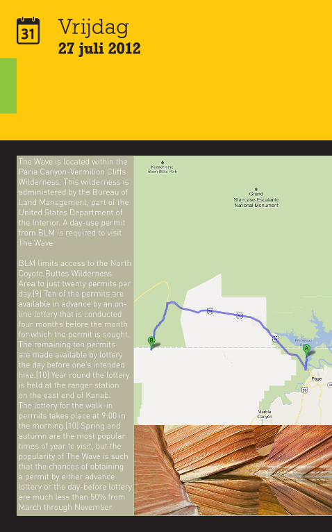
The Wave is located within the Paria Canyon-Vermilion Cliffs Wilderness. This wilderness is administered by the Bureau of Land Management, part of the United States Department of the Interior. A day-use permit from BLM is required to visit The Wave
BLM limits access to the North Coyote Buttes Wilderness Area to just twenty permits per day.[9] Ten of the permits are available in advance by an on-line lottery that is conducted four months before the month for which the permit is sought. The remaining ten permits are made available by lottery the day before one’s intended hike.[10] Year round the lottery is held at the ranger station on the east end of Kanab. The lottery for the walk-in permits takes place at 9:00 in the morning.[10] Spring and autumn are the most popular times of year to visit, but the popularity of The Wave is such that the chances of obtaining a permit by either advance lottery or the day-before lottery are much less than 50% from March through November.
mile45
hrs1.30
hrs8.00
idee14
Triptip
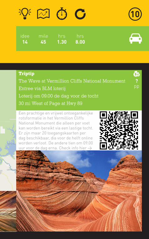
The Wave at Vermillion Cliffs National Monument
Entree via BLM loterij
Loterij om 09.00 de dag voor de tocht
30 mi West of Page at Hwy 89
Een prachtige en vrijwel ontoegankelijke rotsformatie in het Vermillion Cliffs National Monument die alleen per voet kan worden bereikt via een lastige tocht. Er zijn maar 20 toegangskaarten per dag beschikbaar, dia voor de helft online worden verloot. De andere tien om 09.00 uur voor de dag erna. Check info hier >
?pp
Zaterdag28 juli 2012
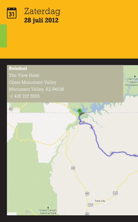
Reisdoel
The View Hotel
Oljato Monument Valley
Monument Valley, AZ 84536
+1 435 727 5555

mile132
hotel16.00
hotel11.00
hrs2.50
Zaterdag28 juli 2012
hrs15.00
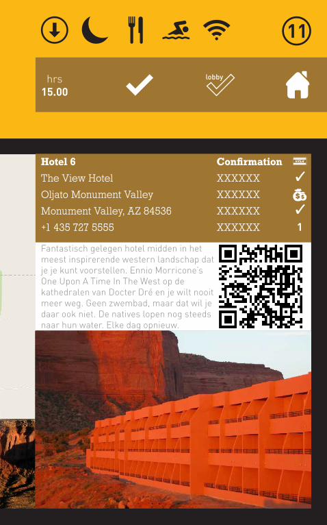
Hotel 6
The View Hotel
Oljato Monument Valley
Monument Valley, AZ 84536
+1 435 727 5555
Confirmation
XXXXXX
XXXXXX
XXXXXX
XXXXXX
Fantastisch gelegen hotel midden in het meest inspirerende western landschap dat je je kunt voorstellen. Ennio Morricone’s One Upon A Time In The West op de kathedralen van Docter Dré en je wilt nooit meer weg. Geen zwembad, maar dat wil je daar ook niet. De natives lopen nog steeds naar hun water. Elke dag opnieuw.
1
lobby
Zaterdag28 juli 2012
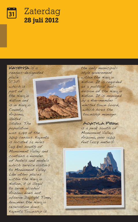
Kayenta is a census-designated place (CDP) which is part of the Nava jo Nation and is in Nava jo County, Arizona, United States. The population was 5, 189 at the 2010 census. Kayenta is located 25 miles (40 km) south of Monument Valley and contains a number of hotels and motels which service visitors to Monument Valley. Like other places within the Nava jo Nation, it is illegal to serve alcohol. Arizona does not observe Daylight Time, however the Nava jo reservation does.Kayenta Township is
the only municipal-style government within the Nava jo Nation. It is regarded as a political sub-division of the Nava jo Nation. It is managed by a five-member elected town board, which hires the township manager.
Agathla Peak is a peak south of Monument Valley, Arizona, over 1500 feet (457 meters)
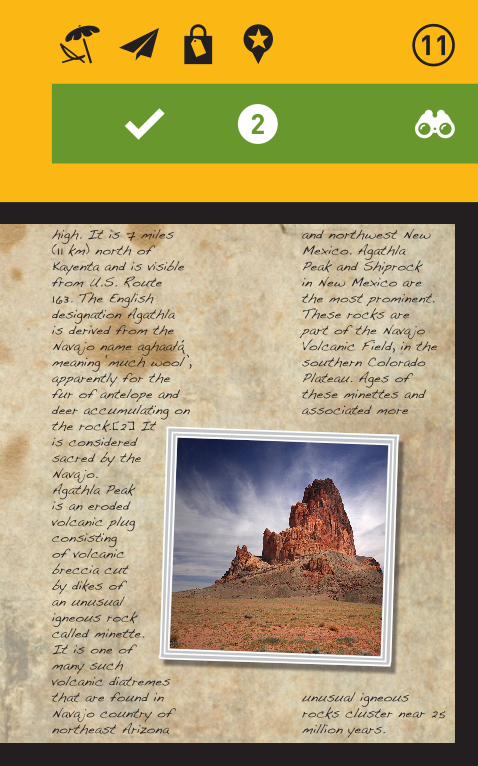
high. It is 7 miles (1 1 km) north of Kayenta and is visible from U.S. Route 163. The English designation Agathla is derived from the Nava jo name aghaałą ́ meaning ‘much wool’, apparently for the fur of antelope and deer accumulating on the rock.[2] It is considered sacred by the Nava jo.Agathla Peak is an eroded volcanic plug consisting of volcanic breccia cut by dikes of an unusual igneous rock called minette. It is one of many such volcanic diatremes that are found in Nava jo country of northeast Arizona
and northwest New Mexico. Agathla Peak and Shiprock in New Mexico are the most prominent. These rocks are part of the Nava jo Volcanic Field, in the southern Colorado Plateau. Ages of these minettes and associated more
unusual igneous rocks cluster near 25 million years.
Zaterdag28 juli 2012
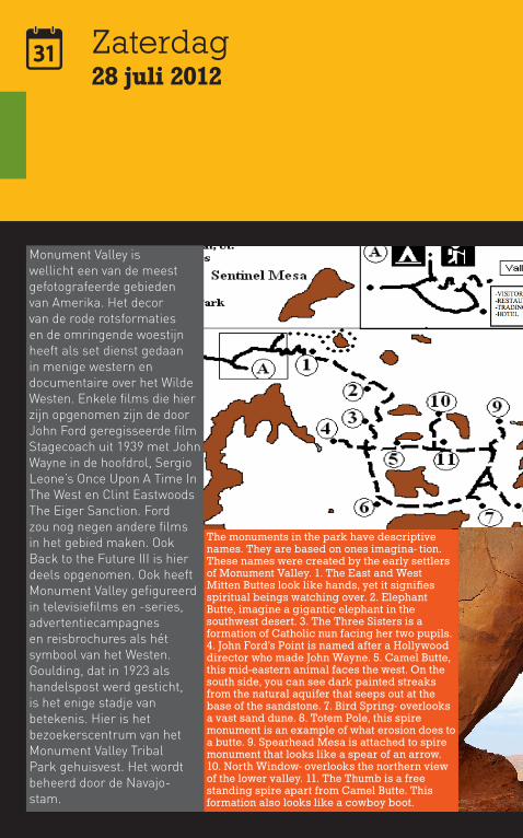
The monuments in the park have descriptive names. They are based on ones imagina- tion. These names were created by the early settlers of Monument Valley. 1. The East and West Mitten Buttes look like hands, yet it signifies spiritual beings watching over. 2. Elephant Butte, imagine a gigantic elephant in the southwest desert. 3. The Three Sisters is a formation of Catholic nun facing her two pupils. 4. John Ford’s Point is named after a Hollywood director who made John Wayne. 5. Camel Butte, this mid- eastern animal faces the west. On the south side, you can see dark painted streaks from the natural aquifer that seeps out at the base of the sandstone. 7. Bird Spring- overlooks a vast sand dune. 8. Totem Pole, this spire monument is an example of what erosion does to a butte. 9. Spearhead Mesa is attached to spire monument that looks like a spear of an arrow. 10. North Window- overlooks the northern view of the lower valley. 11. The Thumb is a free standing spire apart from Camel Butte. This formation also looks like a cowboy boot.
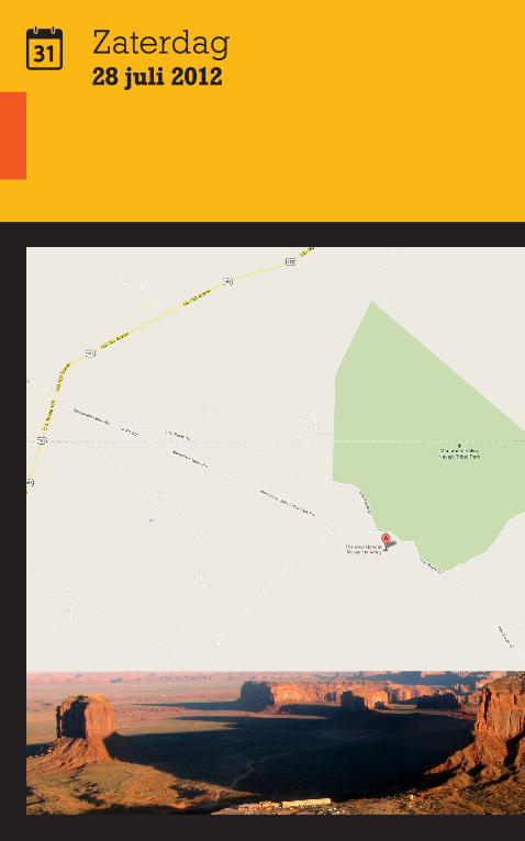
Monument Valley is wellicht een van de meest gefotografeerde gebieden van Amerika. Het decor van de rode rotsformaties en de omringende woestijn heeft als set dienst gedaan in menige western en documentaire over het Wilde Westen. Enkele films die hier zijn opgenomen zijn de door John Ford geregisseerde film Stagecoach uit 1939 met John Wayne in de hoofdrol, Sergio Leone’s Once Upon A Time In The West en Clint Eastwoods The Eiger Sanction. Ford zou nog negen andere films in het gebied maken. Ook Back to the Future III is hier deels opgenomen. Ook heeft Monument Valley gefigureerd in televisiefilms en -series, advertentiecampagnes en reisbrochures als hét symbool van het Westen.Goulding, dat in 1923 als handelspost werd gesticht, is het enige stadje van betekenis. Hier is het bezoekerscentrum van het Monument Valley Tribal Park gehuisvest. Het wordt beheerd door de Navajo-stam.
mile17
hrs1.00
hrs3.00
idee15
Triptip
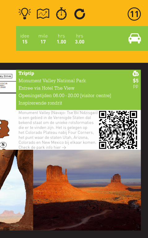
Monument Valley National Park
Entree via Hotel The View
Openingstijden 06.00 - 20.00 [visitor centre]
Inspirerende rondrit
Monument Valley (Navajo: Tse’Bii’Ndzisgaii) is een gebied in de Verenigde Staten dat bekend staat om de unieke rotsformaties die er te vinden zijn. Het is gelegen op het Colorado Plateau nabij Four Corners, het punt waar de staten Utah, Arizona, Colorado en New Mexico bij elkaar komen. Check de park info hier >
$5pp

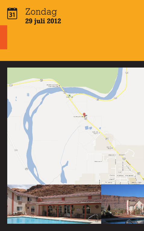
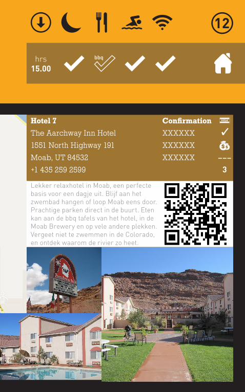
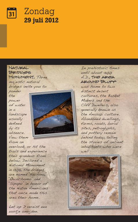
Zondag29 juli 2012
Reisdoel
The Aarchway Inn Hotel
1551 North Highway 191
Moab, UT 84532
+1 435 259 2599
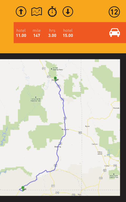
mile147
hotel15.00
hotel11.00
hrs3.00
Zondag29 juli 2012
hrs15.00
Hotel 7
The Aarchway Inn Hotel
1551 North Highway 191
Moab, UT 84532
+1 435 259 2599
Confirmation
XXXXXX
XXXXXX
XXXXXX
Lekker relaxhotel in Moab, een perfecte basis voor een dagje uit. Blijf aan het zwembad hangen of loop Moab eens door. Prachtige parken direct in de buurt. Eten kan aan de bbq tafels van het hotel, in de Moab Brewery en op vele andere plekken. Vergeet niet te zwemmen in de Colorado, en ontdek waarom de rivier zo heet.
���
3
bbq
Zondag29 juli 2012
Natural Bridges Monument. Three ma jestic natural bridges invite you to ponder the power of water in a landscape usually defined by its absence. View them from an overlook, or hit the trails and experience their grandeur from below. Declared a National Monument in 1908, the bridges are named “Kachina,” “Owachomo” and “Sipapu” in honor of the Native Americans that once made this area their home.
Let op > vereist een uurtje omrijden.
In prehistoric times until about 1300 A.D., the area around Bluff was home to two distinct desert cultures, the Basket Makers and the Cliff Dwellers, also generally known as the Anasazi culture. Abandoned dwellings, farms, roads, burial sites, petroglyphs, and pottery remain behind today, telling the stories of ancient inhabitants who were well
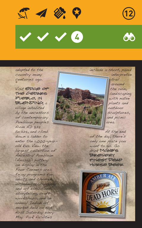
adapted to the country many centuries ago.
Visit Edge of the Cedars Pueblo, in BLENDING a village inhabited by the ancestors of contemporary Puebloan peoples from AD 825 to 1 125, and climb down a ladder to enter the 1,000-year-old kiva. View the largest collection of Ancestral Puebloan (Anasazi) pottery on display in the Four Corners area. Enjoy programs for adults and children, including archaeology and art exhibitions, storytelling, craft workshops, and an annual Indian art market held on the first Saturday every May. Park facilities
include a short, paved interpretive trail around the ruin, landscaping with native plants and outdoor sculptures, and picnic area.
At the end of the day, there’s only one place you want to go. Go drink Moab’s Brewery finest Dead Horse Beer.
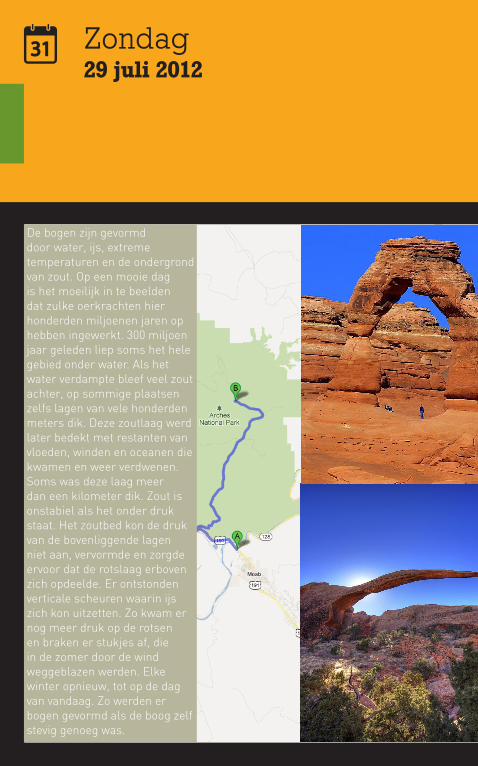
Zondag29 juli 2012
De bogen zijn gevormd door water, ijs, extreme temperaturen en de ondergrond van zout. Op een mooie dag is het moeilijk in te beelden dat zulke oerkrachten hier honderden miljoenen jaren op hebben ingewerkt. 300 miljoen jaar geleden liep soms het hele gebied onder water. Als het water verdampte bleef veel zout achter, op sommige plaatsen zelfs lagen van vele honderden meters dik. Deze zoutlaag werd later bedekt met restanten van vloeden, winden en oceanen die kwamen en weer verdwenen. Soms was deze laag meer dan een kilometer dik. Zout is onstabiel als het onder druk staat. Het zoutbed kon de druk van de bovenliggende lagen niet aan, vervormde en zorgde ervoor dat de rotslaag erboven zich opdeelde. Er ontstonden verticale scheuren waarin ijs zich kon uitzetten. Zo kwam er nog meer druk op de rotsen en braken er stukjes af, die in de zomer door de wind weggeblazen werden. Elke winter opnieuw, tot op de dag van vandaag. Zo werden er bogen gevormd als de boog zelf stevig genoeg was.
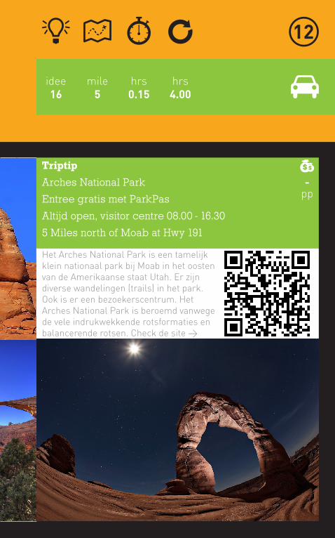
mile5
hrs0.15
hrs4.00
idee16
Triptip
Arches National Park
Entree gratis met ParkPas
Altijd open, visitor centre 08.00 - 16.30
5 Miles north of Moab at Hwy 191
Het Arches National Park is een tamelijk klein nationaal park bij Moab in het oosten van de Amerikaanse staat Utah. Er zijn diverse wandelingen (trails) in het park. Ook is er een bezoekerscentrum. Het Arches National Park is beroemd vanwege de vele indrukwekkende rotsformaties en balancerende rotsen. Check de site >
-pp
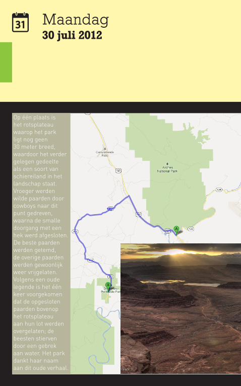
Maandag30 juli 2012
Op één plaats is het rotsplateau waarop het park ligt nog geen 30 meter breed, waardoor het verder gelegen gedeelte als een soort van schiereiland in het landschap staat. Vroeger werden wilde paarden door cowboys naar dit punt gedreven, waarna de smalle doorgang met een hek werd afgesloten. De beste paarden werden getemd, de overige paarden werden gewoonlijk weer vrijgelaten. Volgens een oude legende is het één keer voorgekomen dat de opgesloten paarden bovenop het rotsplateau aan hun lot werden overgelaten; de beesten stierven door een gebrek aan water. Het park dankt haar naam aan dit oude verhaal.

mile30
hrs0.40
hrs3.00
idee17
Triptip
Dead Horse Point Utah State Park
Entree is per auto, max 8 pp per auto
Openingstijden 06.00 - 22.00
9 mi NW of Moab @ US 191 + 23 mi SW @ Utah 313
Dead Horse Point is een klein, hoog gelegen park, dat vooral bekend is dankzij het schitterende uitzicht over de 600 meter lager gelegen Colorado River die daar met een grote bocht om een rotsplateau heendraait. De naam van dit bekende uitkijkpunt is Dead Horse Point Overlook. Check de site >
$10pp
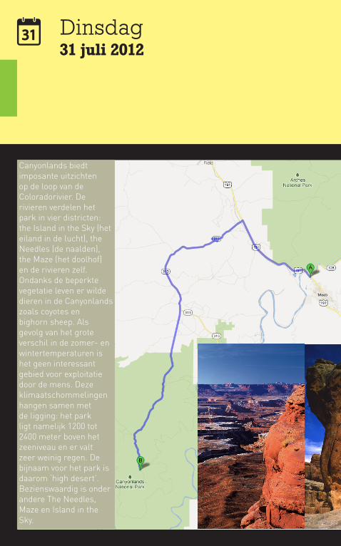
Dinsdag31 juli 2012
Canyonlands biedt imposante uitzichten op de loop van de Coloradorivier. De rivieren verdelen het park in vier districten: the Island in the Sky (het eiland in de lucht), the Needles (de naalden), the Maze (het doolhof) en de rivieren zelf. Ondanks de beperkte vegetatie leven er wilde dieren in de Canyonlands zoals coyotes en bighorn sheep. Als gevolg van het grote verschil in de zomer- en wintertemperaturen is het geen interessant gebied voor exploitatie door de mens. Deze klimaatschommelingen hangen samen met de ligging: het park ligt namelijk 1200 tot 2400 meter boven het zeeniveau en er valt zeer weinig regen. De bijnaam voor het park is daarom ‘high desert’.Bezienswaardig is onder andere The Needles, Maze en Island in the Sky.
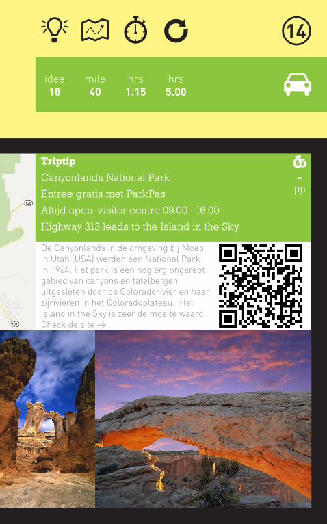
mile40
hrs1.15
hrs5.00
idee18
Triptip
Canyonlands National Park
Entree gratis met ParkPas
Altijd open, visitor centre 09.00 - 16.00
Highway 313 leads to the Island in the Sky
De Canyonlands in de omgeving bij Moab in Utah (USA) werden een National Park in 1964. Het park is een nog erg ongerept gebied van canyons en tafelbergen uitgesleten door de Coloradorivier en haar zijrivieren in het Coloradoplateau. Het Island in the Sky is zeer de moeite waard. Check de site >
-pp
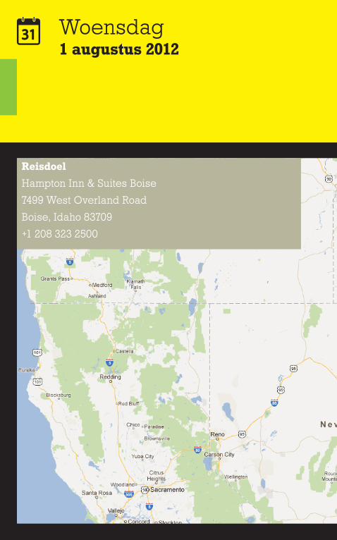
Woensdag1 augustus 2012
Reisdoel
Hampton Inn & Suites Boise
7499 West Overland Road
Boise, Idaho 83709
+1 208 323 2500

mile573
hotel15.00
hotel11.00
hrs11.00
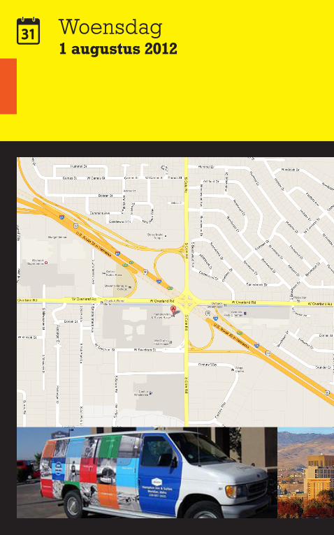
Woensdag1 augustus 2012
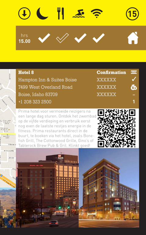
hrs15.00
Hotel 8
Hampton Inn & Suites Boise
7499 West Overland Road
Boise, Idaho 83709
+1 208 323 2500
Confirmation
XXXXXX
XXXXXX
XXXXXX
Prima hotel voor vermoeide reizigers na een lange dag sturen. Ontdek het zwembad op de vijfde verdieping en verbruik eerst nog even de laatste restjes energie in de fitness. Prima restaurants direct in de buurt, te boeken via het hotel, zoals Bone-fish Grill, The Cottonwood Grille, Gino’s of Tablerock Brew Pub & Gril. Klinkt goed!
�
1
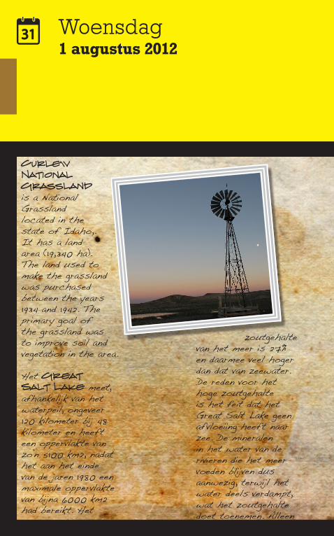
Woensdag1 augustus 2012
Curlew National Grassland is a National Grassland located in the state of Idaho,. It has a land area (19,340 ha).The land used to make the grassland was purchased between the years 1934 and 1942. The primary goal of the grassland was to improve soil and vegetation in the area.
Het Great Salt Lake meet, afhankelijk van het waterpeil, ongeveer 120 kilometer bij 48 kilometer en heeft een oppervlakte van zo’n 5100 km2, nadat het aan het einde van de jaren 1980 een maximale oppervlakte van bijna 6000 km2 had bereikt. Het
zoutgehalte van het meer is 27% en daarmee veel hoger dan dat van zeewater. De reden voor het hoge zoutgehalte is het feit dat het Great Salt Lake geen afvloeiing heeft naar zee. De mineralen in het water van de rivieren die het meer voeden blijven dus aanwezig, terwijl het water deels verdampt, wat het zoutgehalte doet toenemen. Alleen
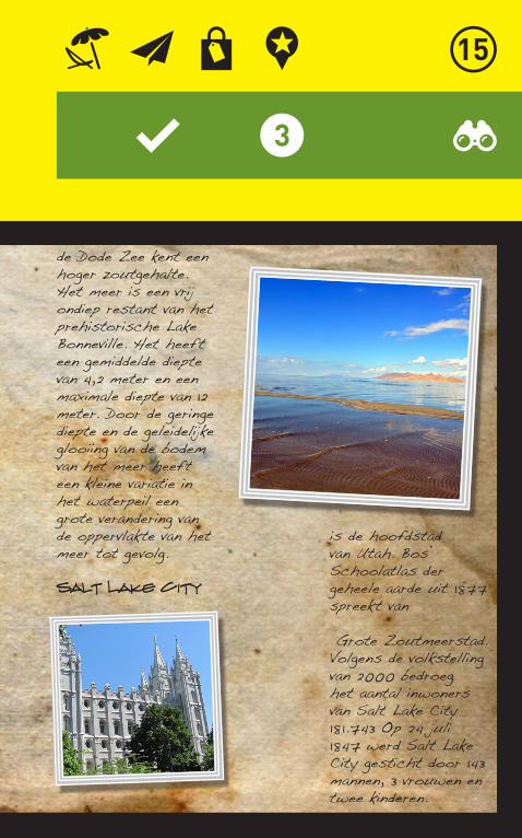
de Dode Zee kent een hoger zoutgehalte.Het meer is een vrij ondiep restant van het prehistorische Lake Bonneville. Het heeft een gemiddelde diepte van 4,2 meter en een maximale diepte van 12 meter. Door de geringe diepte en de geleidelijke glooiing van de bodem van het meer heeft een kleine variatie in het waterpeil een grote verandering van de oppervlakte van het meer tot gevolg.
Salt Lake City
is de hoofdstad van Utah. Bos’ Schoolatlas der geheele aarde uit 1877 spreekt van
Grote Zoutmeerstad. Volgens de volkstelling van 2000 bedroeg het aantal inwoners van Salt Lake City 181.743 Op 24 juli 1847 werd Salt Lake City gesticht door 143 mannen, 3 vrouwen en twee kinderen.
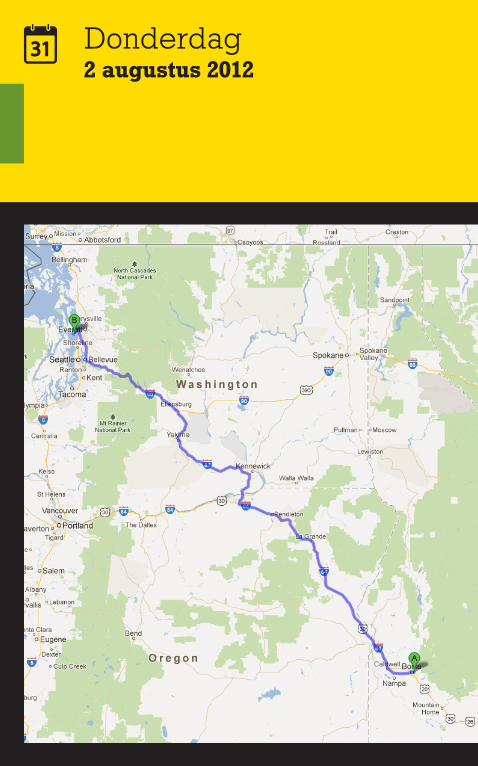
Donderdag2 augustus 2012

mile534
huis16.00
hotel12.00
hrs10.00
Reisdoel
Nancy’s Luxury Cape Cod on Low Bank Sandy Beach
3716 Driftwood Drive
Clinton, Whidbey Island, 98236 WA
+1 206 937 0147
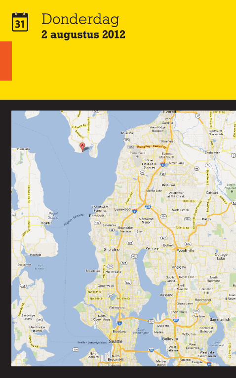
Donderdag2 augustus 2012
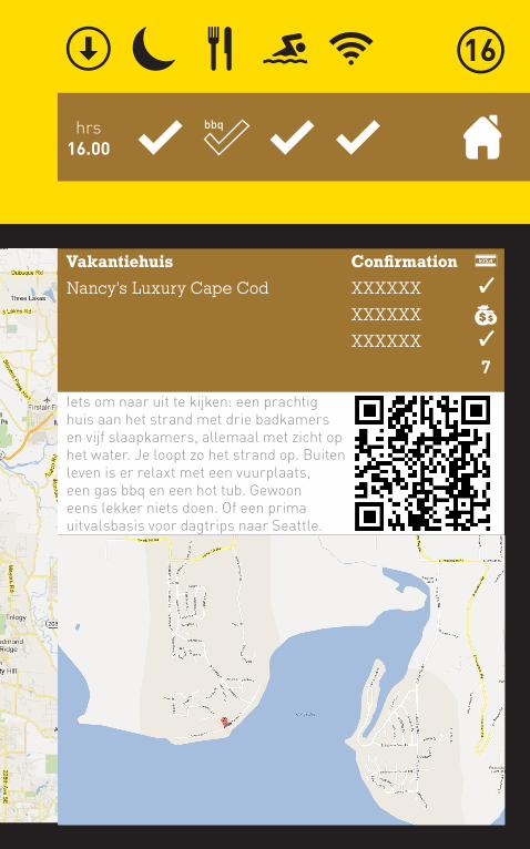
hrs16.00
Vakantiehuis
Nancy’s Luxury Cape Cod
Confirmation
XXXXXX
XXXXXX
XXXXXX
Iets om naar uit te kijken: een prachtig huis aan het strand met drie badkamers en vijf slaapkamers, allemaal met zicht op het water. Je loopt zo het strand op. Buiten leven is er relaxt met een vuurplaats, een gas bbq en een hot tub. Gewoon eens lekker niets doen. Of een prima uitvalsbasis voor dagtrips naar Seattle.
7
bbq
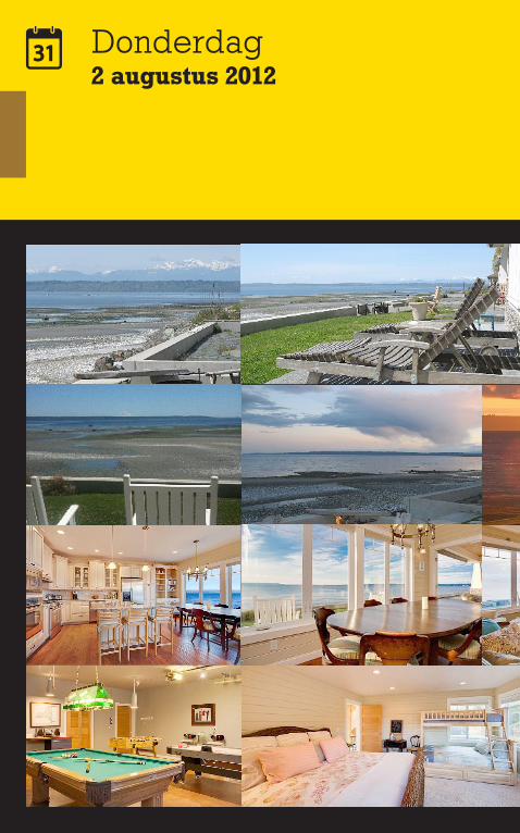
Donderdag2 augustus 2012
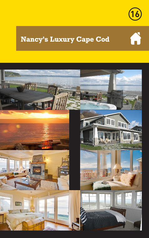
Nancy’s Luxury Cape Cod
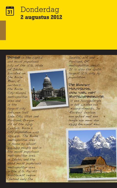
Donderdag2 augustus 2012
Boise is the capital and most populous city of the U.S. state of Idaho. Located on the Boise River, it anchors the Boise City-Nampa metropolitan area and is the largest city between Salt Lake City, Utah and Portland, Oregon.As of the 2010 Census, Boise’s city population was 205,671. The Boise metropolitan area is home to about 616,500 people and is the most populous metropolitan area in Idaho, and the third most populous metropolitan area in the U.S. Pacific Northwest region (behind only the
Seattle, WA and Portland, OR metropolitan areas). It is also the 104th largest U.S. city by population.
De Rocky Mountains, ook wel het Rotsgebergte, is een hooggebergte in het westen van Noord-Amerika. De
‘Rockies’ beslaan een gebied met een lengte van meer dan 4800 km vanaf New
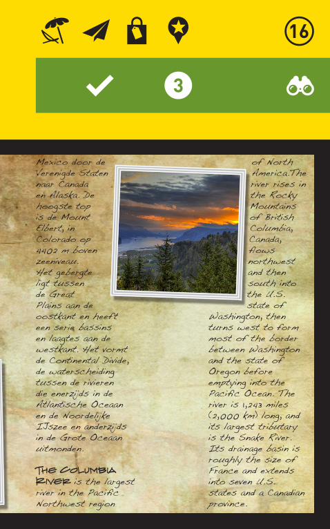
Mexico door de Verenigde Staten naar Canada en Alaska. De hoogste top is de Mount Elbert, in Colorado op 4402 m boven zeeniveau.Het gebergte ligt tussen de Great Plains aan de oostkant en heeft een serie bassins en laagtes aan de westkant. Het vormt de Continental Divide, de waterscheiding tussen de rivieren die enerzijds in de Atlantische Oceaan en de Noordelijke IJszee en anderzijds in de Grote Oceaan uitmonden.
The Columbia River is the largest river in the Pacific Northwest region
of North America.The river rises in the Rocky Mountains of British Columbia, Canada, flows northwest and then south into the U.S. state of
Washington, then turns west to form most of the border between Washington and the state of Oregon before emptying into the Pacific Ocean. The river is 1,243 miles (2,000 km) long, and its largest tributary is the Snake River. Its drainage basin is roughly the size of France and extends into seven U.S. states and a Canadian province.
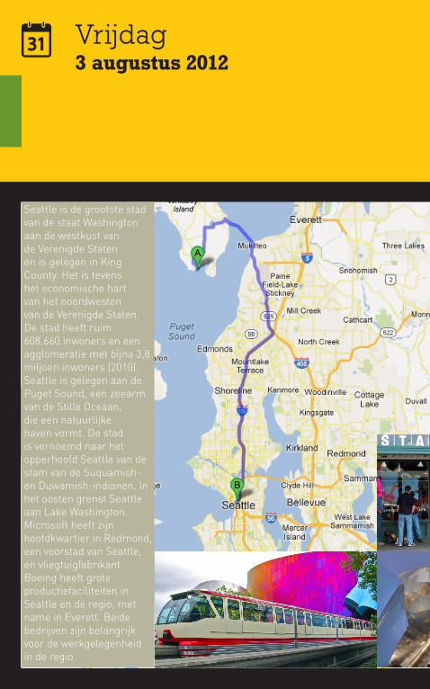
Seattle is de grootste stad van de staat Washington aan de westkust van de Verenigde Staten en is gelegen in King County. Het is tevens het economische hart van het noordwesten van de Verenigde Staten. De stad heeft ruim 608.660 inwoners en een agglomeratie met bijna 3,8 miljoen inwoners (2010).Seattle is gelegen aan de Puget Sound, een zeearm van de Stille Oceaan, die een natuurlijke haven vormt. De stad is vernoemd naar het opperhoofd Seattle van de stam van de Suquamish- en Duwamish-indianen. In het oosten grenst Seattle aan Lake Washington.Microsoft heeft zijn hoofdkwartier in Redmond, een voorstad van Seattle, en vliegtuigfabrikant Boeing heeft grote productiefaciliteiten in Seattle en de regio, met name in Everett. Beide bedrijven zijn belangrijk voor de werkgelegenheid in de regio.
Vrijdag3 augustus 2012
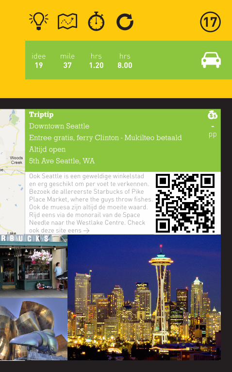
Triptip
Downtown Seattle
Entree gratis, ferry Clinton - Mukilteo betaald
Altijd open
5th Ave Seattle, WA
Ook Seattle is een geweldige winkelstad en erg geschikt om per voet te verkennen. Bezoek de allereerste Starbucks of Pike Place Market, where the guys throw fishes. Ook de muesa zijn altijd de moeite waard. Rijd eens via de monorail van de Space Needle naar the Westlake Centre. Check ook deze site eens >
-pp
mile37
hrs8.00
idee19
hrs1.20
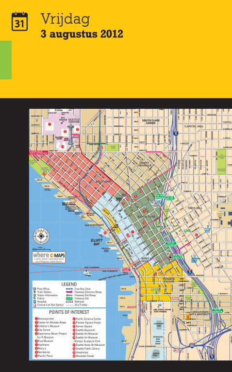
Vrijdag3 augustus 2012
900900
700700
600600
800800
10001000
11001100
13001300
12001200
VIRGIN
IA ST
STEW
ART ST
OCCIDENTAL
S JACKSON
6TH AVE S
5TH AVE S
4TH AVE S
3RD AVE S
2ND AVE S
BATTE
RY ST
WESTERN AVE
PEDESTRIAN
OVERPASS
S WASHINGTON
SENECA ST
SPRING ST
MADISON ST
MARION ST
COLUMBIA ST
CHERRY ST
JAMES ST
UNION ST
JEFFERSON ST
LENORA ST
BROAD ST
BOREN AVE N
PIERS 55 & 56
CAPITOL HILL
FIRST HILL
CHINATOWNINT’L DISTRICT
WHERE®SEATTLEWHERE®SEATTLE
PIER 66
S PLUMMER ST
PL
BIGELOW
MERCER ST
BROAD ST
DENNY WAY
BOYLSTON
BELMONT
BOYLSTON
HARVARD
E BROADWAY
E BROADWAY
FEDERALMERCER ST
PROSPECT
E HARRISON
E THOMAS
E REPUBLICAN
E JOHN
E DENNY
BELLEVUE PL E
WESTLAKE AVE N
E LORETTA
BROADWAY E PL
WAY
HARVARD
E SENECA ST
E UNION ST
E PIKE ST
E PINE ST
E OLIVE ST
PIER64-65
PIER 59
S LANE
S MAIN ST
YESLER WAY
PIER 67
PUBLIC BOAT LANDING
CRUISE TERMINAL FOR:NORWEGIAN CRUISE LINESCELEBRITY CRUISES
BELL ST. PIER CRUISE TERMINAL
PIER 52
PIER 48
PIER 46
PIER 37
PIER 34
S MAIN ST
PIER 69
MINOR AVE N
ROY ST
PONTIUS AVE N
AVE N
VALLEY
YALE
AVE E
JOHN ST
ROY ST
ST
ALOHA ST
WARD
(2 LEVEL)
ALOHA STWARD
FAIR
VIEW A
VE N
QUEEN ANNE AVE N
TERRY AVE9TH AVE
8TH AVE
7TH AVE6TH AVE
5TH AVE
MINOR AVE
YALE
4TH AVE
3RD AVE2ND AVE
BELL S
T
WALL STVIN
E ST
CLAY
ST
BAY ST
PINE ST
9TH AVE
AVE
AVE E
AVE E
MELROSE
AVE E
AVE E
AVE E
AVE EHARVARD
AVE E
FEDERALAVE E
10THAVE E
10THAVE E
AVE E
11THAVE E
BOYLSTON AVE E
ROY ST
12THAVE E
ST
ROY ST
ST
BELMONT
PL E
ST
ST
WAY
PL
E HOWELL
E OL
IVE
AVE
NAGELAVE
12TH AVE
11THAVE E
10THAVE E
12THAVE E
BOREN
AVE
OCCIDENTAL AVE S
AIRPORT WAY S
ALASKAN WAY S
TO FERRIES
12TH AVE S
L A K E U N I O N
BROADWAYPLAYFIELD
1ST AVE S
PIER 70
CHANDLER’S COVE
S JACKSON ST
S KING
PIER 57
4TH AVE S
BELLEVUE
SUMM
IT
PIER 54
VOLUNTEER PARK
FERRY TO BAINBRIDGE
FERRY TO BREMERTON
SEATTLEUNIV
TAYLOR AVE N
6TH AVE N
8TH AVE N8TH AVE N
9TH AVE N
DEXTER AVE N
DENNYPARK
FREEWAYPARK
HING HAYPARK
KOBETERRACE
PARK
MYRTLEEDWARDS
PARK
OLYMPIC SCULPTURE
PARK
9TH AVE
8TH AVE
7TH AVE
7TH AVE
8TH AVE
6TH AVE2ND AVE1ST AVE
POST AVE
PIKE PL
PIKE ST
HARBOR
STEPS
5TH AVE4TH AVE3RD AVE
SEATTLECENTER
LAKE UNION
INT’LFOUNTAIN
EXHIBITIONHALL
MCCAW HALL
INTIMANPLAYHOUSE
SEATTLE REP
SEATTLE MONORAIL
TO UPPER QUEEN ANNE
TO BALLARD AND THEHIRAM M. CHITTENDEN LOCKS
ELLIOTTBAY
STATE FERRYTERMINAL
TO FREMONT
23002300
2400
2400
2600
2600
2800
2800
2900
2900
3000
3000
BROAD ST
TO SEATTLE CENTER
TO SEATTLE CENTER
CHILDREN'STHEATRE
CHILDREN'STHEATRE
QUEENANNE
S DEARBORN ST
S CHARLES ST
MERCER ST
PROSPECT ST
VALLEY ST
WESTERN AVE
ELLIOTT AVE
EAGLE
ST
JOHN ST
THOMAS ST
HARRISON ST
REPUBLICAN ST
ALDER ST
SPRUCE ST
SENECA ST
UNIVERSITY ST
E SPRUCE ST
E FIRST ST
MAYNARD AVE S
ALASKAN WAY VIADUCT
HIGHLAND DR
WARD ST
WARREN AVE N
HOWELL S
T
BLANCHARD ST
STEW
ART ST
BOREN AVE
2ND AVE N
OLIVE WAY
10TH AVE
BROADWAY 11TH AVE
10TH AVE
12TH AVE E
ALASKAN WAY
VALLEY ST
S ROYAL BROUGHAM WAY
S LANE
S WELLER
99 TU
NNEL
TAYLOR AVE N
5TH AVE N
6TH AVE N
FAIRVIEW AVE N
DENNY WAY
TERRY AVE N
EASTLAKE
THOMAS ST
REPUBLICAN ST
HARRISON ST
WESTLAKE AVE N
DEXTER AVE NAURORA AVE N
4TH AVE N
3RD AVE N
2ND AVE N
WARREN AVE
NOB HILL N
KLONDIKENAT’L PARK
TERRY AVE
8TH AVE S
7TH AVE S
POST ALLEY
PIKE
HILLCLIMB
PEDESTRIANOVERPASS
WATERFRONTELEVATOR
BOREN AVE
MELROSE AVE
BELLEVUE AVE
SUMM
IT AVE
BELMONT AVE
BOYLSTON AVE
CRAWFORD PL
MINOR AVE
SUMM
IT AVE
1ST AVE W
1ST AVE N1ST AVE N
PIKEPLACE
MARKET
PINE ST
S KING ST
PIONEERSQUARE
SEATTLEMONORAIL
BELLTOWN
DENNYTRIANGLECE
DAR ST
ELLIOTT AVE
1ST AVE
WESTERN AVE. EXIT
SENE
CA ST EXIT
WATERFRONT
1800
1800
1900
1900
2000
2000
2100
2100
2200
2200
100 N100 N
200 N200 N
300 N300 N
400 N400 N
500 N500 N
SOUTH LAKEUNION
SOUTH LAKEUNION
17001700
800 S
600 S
500 S
400 S
300 S
100 S
A
JEFFERSON STJAMES STCHERRY ST
COLUMBIA STMARION ST
TERRACE ST
HARBORVIEW MEDICAL CENTER
HARBORVIEW MEDICAL CENTER
SAFECO FIELD
KING STREET STATIONTRAIN TERMINAL
200 S
PIER 30
KING COUNTY WATER TAXI TO WEST SEATTLE
SPACENEEDLESPACENEEDLE
E COLUMBIA ST
FISHERPLAZA
WASHINGTONSTATE
CONVENTIONCENTER
TO WOODLAND PARK ZOO
DENNY WAY EXIT
SEATTLE CENTER/MERCER ST. EXIT #167
PIKE ST
ST. JAMESCATHEDRAL
SEATTLE MONORAIL
WESTEDGE
RETAIL CORE
VIADUCT (2 LEVEL)ALASKAN W
AY
WALL S
T. EX
IT
CALANDERSON
PARK
1ST AVE S
4TH AVE S
6TH AVE S
AIRPORT WAY S
AIRPORT WAY S
8TH AVE S
7TH AVE S
BUSWAY
PIER 50
UNIVERSITY ST
99
99
99
99
99
13TH AVE E
14TH AVE E
E JEFFERSON ST
E `CHERRY ST
E COLUMBIA ST
E MARION ST
E UNION ST
13TH AVE E
14TH AVE E
E YESLER WAY
S KING
35
2
CenturyLinkField
CenturyLinkFieldEventCenter
SWEDISHMEDICAL CENTER
KENMOREAIR
ARGOSYCRUISES
CLIPPERVACATIONS
StadiumCentral Link
Int’l DistrictCentral Link
Pioneer SqCentral Link
Univ. St.CentralLink
WestlakeCentral Link
11 Pacific Science Center12 Pioneer Square Pergol13 Rainier Square14 Seattle Aquarium15 Seattle Art Museum16 Seattle Art Museum–Olympic Sculpture Park17 Seattle Asian Art Museum18 Seattle Public Library19 Uwajimaya20 Westlake Center
1 Benaroya Hall2 Center for Wooden Boats3 Children's Museum4 City Centre 5 Experience Music Project–Sci-Fi Museum6 Frye Museum7 KeyArena8 Macy's9 Nordstrom10 Pacific Place
POINTS OF INTEREST
115
14
18
12
19
6
8
9
10
20
13
4
16
11
7
17
LEGENDPost OfficeTrain StationVisitor InformationPoliceHospitalCentral Link Rail Station
Free Bus ZoneFreeway Entrance RampFreeway Exit RampFreeway Exit RailroadSLU Trolley
Exit 165AJames St
Exit 164Columbia St
Exit 166Olive Way
Exit 167Seattle Center
Exit 165BUnion St
Exit 164Dearborn St
Exit 165AJames St
5
5
90
90
5
5
5
SCALE1/8 mi250 m
1
2
3
4
5
6
7
8
9
A B C D E F H I J K LG
10
11
12
13
14
15
1
2
3
4
5
6
7
8
9
10
11
12
13
14
15
A B C D E F H I J K LG
C
M
Y
CM
MY
CY
CMY
K
Seattle DT_Map2012.pdf 12/12/11 11:23:46 AM
SoDo
Uptown
First Hill
South Lake Union
Capitol Hill
Retail Core
BelltownDenny Triangle
Waterfront
West Edge
Pioneer Square
Chinatown:International District
SR99
I-5FR
WY
1STAVE
5THAVE
4THAVE
3RDAVE
2NDAVE
6TH AVE
1ST
AVE
S
4TH
AVE
S
12TH
AVE
BOREN
AVE
8THAVE
5TH
AVE
S
ALASKAN WAY
WESTERN AVE
DENNY WAY
ROY ST
PIKE ST
6TH
AVE
S
7TH AVE
13TH
AVE
PINE ST
SPRING ST
MERCER ST
3RD
AVE
S
5TH
AVE
N
BELLST
HARRISON ST
BROADST
THOMAS ST
9THAVE
JOHN ST
SENECA STMADISON ST
S JACKSON ST
11TH
AVE
UTA
HAV
ES
RAM
P
S KING ST
DEX
TER
AVE
N
JAMES ST
STEW
ART ST
1ST
AVE
N
2ND
AVE
N
1ST
AVE
W
I-90 FRWY
ELLIOTT AVE
EAST
LAK
EAV
EE
FAIR
VIE
WAV
EN
CHERRY ST
VIRGIN
IAST
MINO
RAVE
LENORA
ST
WALLST
VINE
ST
2ND
AVE
W
E PIKE ST
E PINE ST
9TH
AVE
N
OLIVE WAY
YESLER WAY
WE
STLA
KE
AVE
N
S LANDER STBR
OAD
WAY
3RD
AVE
W
TER
RY
AVE
N
E UNION ST
E DENNY WAY
ELLIOTT AVEW
S DEARBORN ST
E ROY ST
CLAY
ST
SUM
MIT
AVE
12TH
AVE
E
MARION ST
BATTE
RYST
WARD ST
W ROY ST
YALE
AVE
N
TAYL
OR
AVE
N
E MERCER ST
E THOMAS ST
BLANCHARD
ST
VALLEY ST
HAR
VAR
DAV
E
BOR
ENAV
EN
E HARRISON ST
QU
EEN
ANN
EAV
EN
CEDARST
S ROYAL BROUGHAM WAY
BELL
EVU
EAV
EE
ALASKANW
AYW
W OLYMPIC PL
BELM
ON
TAV
EE
6TH
AVE
N
E OLIVE WAY
MIN
OR
AVE
N
S MAIN ST
E REPUBLICAN ST
W PROSPECT ST
4TH
AVE
W
BRO
ADW
AYE
S ATLANTIC ST
BELL
EVU
EAV
E
WA
RR
ENAV
EN
BOYLSTO
NAVE
8TH
AVE
N
NAG
LEP
L
GALER ST
PIKE PL
EAST
MA
RG
INA
LW
AYS
UNIVERSITY ST
BELM
ON
TAV
E
HAR
VAR
DAV
EE
S STACY ST
COLUMBIA ST
E FIR ST
ME
LRO
SE
AVE
CR
AWFO
RD
PL
OC
CID
ENTA
LAV
ES
E ALDER ST
S WALKER ST
E MADISON ST
AIRPORT
WAY
S
TERRYAVE
ALDER ST
UNION ST
FED
ER
AL
AVE
E
E MARION ST
STURGUS
AVES
POST
ALY
3RD
AVE
N
HIGHLAND DR
ALA
SKA
NW
AYS
E JOHN ST
2ND
AVE
S
BOYL
STO
NAV
EE
W HARRISON ST
W KINNEAR PL
BELM
ON
TPL
E
JEFFERSON ST
ALOHA STW MERCER PL
POST
AVE
5TH
AVE
W
W THOMAS ST
11TH
AVE
E
8TH
AVE
S
10TH
AVE
E
E SPRING ST
12TH
AVE
S
LEE ST
S HOLGATE BR
E TERRACE ST
E YESLER WAY
EAGLEST
LAKE
VIEW
BLVD
E
S MASSACHUSETTS ST
GOLF DRS
REPUBLICAN ST
YALE AVE
NO
BH
ILL
AVE
N
5TH
PLS
S JUDKINS ST
SUM
MIT
AVE
E
FAIR
VIE
WAV
EE
E SPRUCE ST
15THAVE
S
E HOWELL ST
BAYST
10TH
AVE
E COLUMBIA ST
E JAMES WAY
CO
LOR
AD
OAV
ES
4TH
AVE
N
S CHARLES ST
FRAN
KLIN
AVE
E
SPRUCE ST
11TH
AVE
S
6TH
AVE
W
7TH
AVE
W
HAYES ST
PON
TIU
SAV
EN
W ALOHA ST
TERRACE ST
COURT PL
S BAYVIEW ST
S HILL ST
PROSPECT ST
GARFIELD ST
6TH
AVE
S
PON
TIU
SAV
EN
PINE ST
HAR
VAR
DAV
EE
SUMM
IT AVE
7THAVE
MIN
OR
AVE
N
RAMP
RAMP
9TH AVE
RAMP
TAYL
OR
AVE
N
RAMP
TERRY AVE
RAM
P
S MAIN ST
6TH
AVE
W
8TH
AVE
N
ALOHA ST
REPUBLICAN ST
5TH
AVE
W
UNION ST
S WALKER ST
S STACY ST
OC
CID
ENTA
LAV
ES
RAM
P
RAMP
12TH
AVE
S
TERRYAVE
4TH
AVE
N
PROSPECT ST
I-5FRW
Y
E JOHN ST
SUM
MIT
AVE
E
4TH
AVE
N
BAYST
I-90 FRWY
ALA
SKA
NW
AYS
RAM
P
VALLEY ST
8TH
AVE
S
MARION ST
8TH AVE
RAMP
E ROY ST
WA
RR
ENAV
EN
LEE ST
RAM
P
YALE
AVEN
BOYL
STO
NAV
EE
8TH
AVE
S
Downtown Neighborhoods
Last Updated February 2, 2010
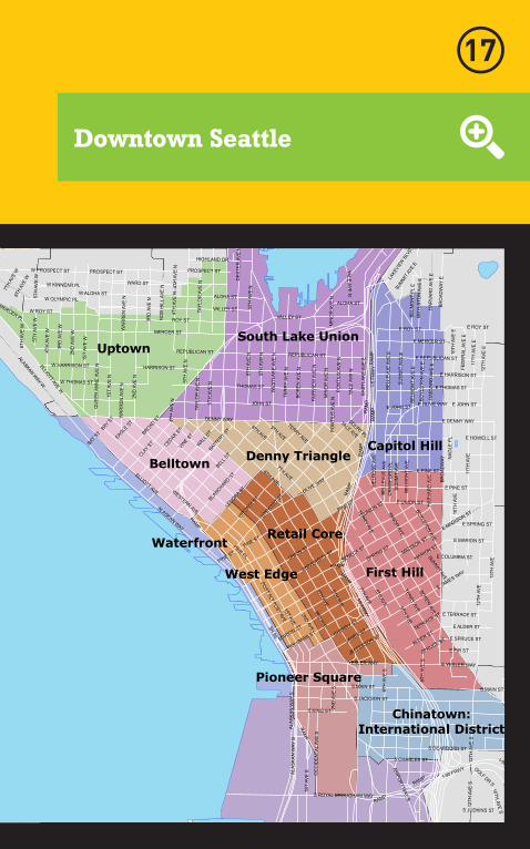
900900
700700
600600
800800
10001000
11001100
13001300
12001200
VIRGIN
IA ST
STEW
ART ST
OCCIDENTAL
S JACKSON
6TH AVE S
5TH AVE S
4TH AVE S
3RD AVE S
2ND AVE S
BATTE
RY ST
WESTERN AVE
PEDESTRIAN
OVERPASS
S WASHINGTON
SENECA ST
SPRING ST
MADISON ST
MARION ST
COLUMBIA ST
CHERRY ST
JAMES ST
UNION ST
JEFFERSON ST
LENORA ST
BROAD ST
BOREN AVE N
PIERS 55 & 56
CAPITOL HILL
FIRST HILL
CHINATOWNINT’L DISTRICT
WHERE®SEATTLEWHERE®SEATTLE
PIER 66
S PLUMMER ST
PL
BIGELOW
MERCER ST
BROAD ST
DENNY WAY
BOYLSTON
BELMONT
BOYLSTON
HARVARD
E BROADWAY
E BROADWAY
FEDERALMERCER ST
PROSPECT
E HARRISON
E THOMAS
E REPUBLICAN
E JOHN
E DENNY
BELLEVUE PL E
WESTLAKE AVE N
E LORETTA
BROADWAY E PL
WAY
HARVARD
E SENECA ST
E UNION ST
E PIKE ST
E PINE ST
E OLIVE ST
PIER64-65
PIER 59
S LANE
S MAIN ST
YESLER WAY
PIER 67
PUBLIC BOAT LANDING
CRUISE TERMINAL FOR:NORWEGIAN CRUISE LINESCELEBRITY CRUISES
BELL ST. PIER CRUISE TERMINAL
PIER 52
PIER 48
PIER 46
PIER 37
PIER 34
S MAIN ST
PIER 69
MINOR AVE N
ROY ST
PONTIUS AVE N
AVE N
VALLEY
YALE
AVE E
JOHN ST
ROY ST
ST
ALOHA ST
WARD
(2 LEVEL)
ALOHA ST
WARD
FAIR
VIEW A
VE N
QUEEN ANNE AVE N
TERRY AVE9TH AVE
8TH AVE
7TH AVE6TH AVE
5TH AVE
MINOR AVE
YALE
4TH AVE
3RD AVE2ND AVE
BELL S
T
WALL STVIN
E ST
CLAY
ST
BAY ST
PINE ST
9TH AVE
AVE
AVE E
AVE E
MELROSE
AVE E
AVE E
AVE E
AVE EHARVARD
AVE E
FEDERALAVE E
10THAVE E
10THAVE E
AVE E
11THAVE E
BOYLSTON AVE E
ROY ST
12THAVE E
ST
ROY ST
ST
BELMONT
PL E
ST
ST
WAY
PL
E HOWELL
E OL
IVE
AVE
NAGELAVE
12TH AVE
11THAVE E
10THAVE E
12THAVE E
BOREN
AVE
OCCIDENTAL AVE S
AIRPORT WAY S
ALASKAN WAY S
TO FERRIES
12TH AVE S
L A K E U N I O N
BROADWAYPLAYFIELD
1ST AVE S
PIER 70
CHANDLER’S COVE
S JACKSON ST
S KING
PIER 57
4TH AVE S
BELLEVUE
SUMM
IT
PIER 54
VOLUNTEER PARK
FERRY TO BAINBRIDGE
FERRY TO BREMERTON
SEATTLEUNIV
TAYLOR AVE N
6TH AVE N
8TH AVE N8TH AVE N
9TH AVE N
DEXTER AVE N
DENNYPARK
FREEWAYPARK
HING HAYPARK
KOBETERRACE
PARK
MYRTLEEDWARDS
PARK
OLYMPIC SCULPTURE
PARK
9TH AVE
8TH AVE
7TH AVE
7TH AVE
8TH AVE
6TH AVE2ND AVE1ST AVE
POST AVE
PIKE PL
PIKE ST
HARBOR
STEPS
5TH AVE4TH AVE3RD AVE
SEATTLECENTER
LAKE UNION
INT’LFOUNTAIN
EXHIBITIONHALL
MCCAW HALL
INTIMANPLAYHOUSE
SEATTLE REP
SEATTLE MONORAIL
TO UPPER QUEEN ANNE
TO BALLARD AND THEHIRAM M. CHITTENDEN LOCKS
ELLIOTTBAY
STATE FERRYTERMINAL
TO FREMONT
23002300
2400
2400
2600
2600
2800
2800
2900
2900
3000
3000
BROAD ST
TO SEATTLE CENTER
TO SEATTLE CENTER
CHILDREN'STHEATRE
CHILDREN'STHEATRE
QUEENANNE
S DEARBORN ST
S CHARLES ST
MERCER ST
PROSPECT ST
VALLEY ST
WESTERN AVE
ELLIOTT AVE
EAGLE
ST
JOHN ST
THOMAS ST
HARRISON ST
REPUBLICAN ST
ALDER ST
SPRUCE ST
SENECA ST
UNIVERSITY ST
E SPRUCE ST
E FIRST ST
MAYNARD AVE S
ALASKAN WAY VIADUCT
HIGHLAND DR
WARD ST
WARREN AVE N
HOWELL S
T
BLANCHARD ST
STEW
ART ST
BOREN AVE
2ND AVE N
OLIVE WAY
10TH AVE
BROADWAY 11TH AVE
10TH AVE
12TH AVE E
ALASKAN WAY
VALLEY ST
S ROYAL BROUGHAM WAY
S LANE
S WELLER
99 TU
NNEL
TAYLOR AVE N
5TH AVE N
6TH AVE N
FAIRVIEW AVE N
DENNY WAY
TERRY AVE N
EASTLAKE
THOMAS ST
REPUBLICAN ST
HARRISON ST
WESTLAKE AVE N
DEXTER AVE NAURORA AVE N
4TH AVE N
3RD AVE N
2ND AVE N
WARREN AVE
NOB HILL N
KLONDIKENAT’L PARK
TERRY AVE
8TH AVE S
7TH AVE S
POST ALLEY
PIKE
HILLCLIMB
PEDESTRIANOVERPASS
WATERFRONTELEVATOR
BOREN AVE
MELROSE AVE
BELLEVUE AVE
SUMM
IT AVE
BELMONT AVE
BOYLSTON AVE
CRAWFORD PL
MINOR AVE
SUMM
IT AVE
1ST AVE W
1ST AVE N1ST AVE N
PIKEPLACE
MARKET
PINE ST
S KING ST
PIONEERSQUARE
SEATTLEMONORAIL
BELLTOWN
DENNYTRIANGLECE
DAR ST
ELLIOTT AVE
1ST AVE
WESTERN AVE. EXIT
SENE
CA ST EXIT
WATERFRONT
1800
1800
1900
1900
2000
2000
2100
2100
2200
2200
100 N100 N
200 N200 N
300 N300 N
400 N400 N
500 N500 N
SOUTH LAKEUNION
SOUTH LAKEUNION
17001700
800 S
600 S
500 S
400 S
300 S
100 S
A
JEFFERSON STJAMES STCHERRY ST
COLUMBIA STMARION ST
TERRACE ST
HARBORVIEW MEDICAL CENTER
HARBORVIEW MEDICAL CENTER
SAFECO FIELD
KING STREET STATIONTRAIN TERMINAL
200 S
PIER 30
KING COUNTY WATER TAXI TO WEST SEATTLE
SPACENEEDLESPACENEEDLE
E COLUMBIA ST
FISHERPLAZA
WASHINGTONSTATE
CONVENTIONCENTER
TO WOODLAND PARK ZOO
DENNY WAY EXIT
SEATTLE CENTER/MERCER ST. EXIT #167
PIKE ST
ST. JAMESCATHEDRAL
SEATTLE MONORAIL
WESTEDGE
RETAIL CORE
VIADUCT (2 LEVEL)ALASKAN W
AY
WALL S
T. EX
IT
CALANDERSON
PARK
1ST AVE S
4TH AVE S
6TH AVE S
AIRPORT WAY S
AIRPORT WAY S
8TH AVE S
7TH AVE S
BUSWAY
PIER 50
UNIVERSITY ST
99
99
99
99
99
13TH AVE E
14TH AVE E
E JEFFERSON ST
E `CHERRY ST
E COLUMBIA ST
E MARION ST
E UNION ST
13TH AVE E
14TH AVE E
E YESLER WAY
S KING
35
2
CenturyLinkField
CenturyLinkFieldEventCenter
SWEDISHMEDICAL CENTER
KENMOREAIR
ARGOSYCRUISES
CLIPPERVACATIONS
StadiumCentral Link
Int’l DistrictCentral Link
Pioneer SqCentral Link
Univ. St.CentralLink
WestlakeCentral Link
11 Pacific Science Center12 Pioneer Square Pergol13 Rainier Square14 Seattle Aquarium15 Seattle Art Museum16 Seattle Art Museum–Olympic Sculpture Park17 Seattle Asian Art Museum18 Seattle Public Library19 Uwajimaya20 Westlake Center
1 Benaroya Hall2 Center for Wooden Boats3 Children's Museum4 City Centre 5 Experience Music Project–Sci-Fi Museum6 Frye Museum7 KeyArena8 Macy's9 Nordstrom10 Pacific Place
POINTS OF INTEREST
115
14
18
12
19
6
8
9
10
20
13
4
16
11
7
17
LEGENDPost OfficeTrain StationVisitor InformationPoliceHospitalCentral Link Rail Station
Free Bus ZoneFreeway Entrance RampFreeway Exit RampFreeway Exit RailroadSLU Trolley
Exit 165AJames St
Exit 164Columbia St
Exit 166Olive Way
Exit 167Seattle Center
Exit 165BUnion St
Exit 164Dearborn St
Exit 165AJames St
5
5
90
90
5
5
5
SCALE1/8 mi250 m
1
2
3
4
5
6
7
8
9
A B C D E F H I J K LG
10
11
12
13
14
15
1
2
3
4
5
6
7
8
9
10
11
12
13
14
15
A B C D E F H I J K LG
C
M
Y
CM
MY
CY
CMY
K
Seattle DT_Map2012.pdf 12/12/11 11:23:46 AM
SoDo
Uptown
First Hill
South Lake Union
Capitol Hill
Retail Core
BelltownDenny Triangle
Waterfront
West Edge
Pioneer Square
Chinatown:International District
SR99
I-5FR
WY
1STAVE
5THAVE
4THAVE
3RDAVE
2NDAVE
6TH AVE
1ST
AVE
S
4TH
AVE
S
12TH
AVE
BOREN
AVE
8THAVE
5TH
AVE
S
ALASKAN WAY
WESTERN AVE
DENNY WAY
ROY ST
PIKE ST
6TH
AVE
S
7TH AVE
13TH
AVE
PINE ST
SPRING ST
MERCER ST
3RD
AVE
S
5TH
AVE
N
BELLST
HARRISON ST
BROADST
THOMAS ST
9THAVE
JOHN ST
SENECA STMADISON ST
S JACKSON ST
11TH
AVE
UTA
HAV
ES
RAM
P
S KING ST
DEX
TER
AVE
N
JAMES ST
STEW
ART ST
1ST
AVE
N
2ND
AVE
N
1ST
AVE
W
I-90 FRWY
ELLIOTT AVE
EAST
LAK
EAV
EE
FAIR
VIE
WAV
EN
CHERRY ST
VIRGIN
IAST
MINO
RAVE
LENORA
ST
WALLST
VINE
ST
2ND
AVE
W
E PIKE ST
E PINE ST
9TH
AVE
N
OLIVE WAY
YESLER WAY
WE
STLA
KE
AVE
N
S LANDER ST
BRO
ADW
AY
3RD
AVE
W
TER
RY
AVE
N
E UNION ST
E DENNY WAY
ELLIOTT AVEW
S DEARBORN ST
E ROY ST
CLAY
ST
SUM
MIT
AVE
12TH
AVE
E
MARION ST
BATTE
RYST
WARD ST
W ROY ST
YALE
AVE
N
TAYL
OR
AVE
N
E MERCER ST
E THOMAS ST
BLANCHARD
ST
VALLEY ST
HAR
VAR
DAV
E
BOR
ENAV
EN
E HARRISON ST
QU
EEN
ANN
EAV
EN
CEDARST
S ROYAL BROUGHAM WAY
BELL
EVU
EAV
EE
ALASKANW
AYW
W OLYMPIC PL
BELM
ON
TAV
EE
6TH
AVE
N
E OLIVE WAY
MIN
OR
AVE
N
S MAIN ST
E REPUBLICAN ST
W PROSPECT ST
4TH
AVE
W
BRO
ADW
AYE
S ATLANTIC ST
BELL
EVU
EAV
E
WA
RR
ENAV
EN
BOYLSTO
NAVE
8TH
AVE
N
NAG
LEP
L
GALER ST
PIKE PL
EAST
MA
RG
INA
LW
AYS
UNIVERSITY ST
BELM
ON
TAV
E
HAR
VAR
DAV
EE
S STACY ST
COLUMBIA ST
E FIR ST
ME
LRO
SE
AVE
CR
AWFO
RD
PL
OC
CID
ENTA
LAV
ES
E ALDER ST
S WALKER ST
E MADISON ST
AIRPORT
WAY
S
TERRYAVE
ALDER ST
UNION ST
FED
ER
AL
AVE
E
E MARION ST
STURGUS
AVES
POST
ALY
3RD
AVE
N
HIGHLAND DR
ALA
SKA
NW
AYS
E JOHN ST
2ND
AVE
S
BOYL
STO
NAV
EE
W HARRISON ST
W KINNEAR PL
BELM
ON
TPL
E
JEFFERSON ST
ALOHA STW MERCER PL
POST
AVE
5TH
AVE
W
W THOMAS ST
11TH
AVE
E
8TH
AVE
S
10TH
AVE
E
E SPRING ST
12TH
AVE
S
LEE ST
S HOLGATE BR
E TERRACE ST
E YESLER WAY
EAGLEST
LAKE
VIEW
BLVD
E
S MASSACHUSETTS ST
GOLF DRS
REPUBLICAN ST
YALE AVE
NO
BH
ILL
AVE
N
5TH
PLS
S JUDKINS ST
SUM
MIT
AVE
E
FAIR
VIE
WAV
EE
E SPRUCE ST
15THAVE
S
E HOWELL ST
BAYST
10TH
AVE
E COLUMBIA ST
E JAMES WAY
CO
LOR
AD
OAV
ES
4TH
AVE
N
S CHARLES ST
FRAN
KLIN
AVE
E
SPRUCE ST
11TH
AVE
S
6TH
AVE
W
7TH
AVE
W
HAYES ST
PON
TIU
SAV
EN
W ALOHA ST
TERRACE ST
COURT PL
S BAYVIEW ST
S HILL ST
PROSPECT ST
GARFIELD ST
6TH
AVE
S
PON
TIU
SAV
EN
PINE ST
HAR
VAR
DAV
EE
SUMM
IT AVE
7THAVE
MIN
OR
AVE
N
RAMP
RAMP
9TH AVE
RAMP
TAYL
OR
AVE
N
RAMP
TERRY AVE
RAM
P
S MAIN ST
6TH
AVE
W
8TH
AVE
N
ALOHA ST
REPUBLICAN ST
5TH
AVE
W
UNION ST
S WALKER ST
S STACY ST
OC
CID
ENTA
LAV
ES
RAM
P
RAMP
12TH
AVE
S
TERRYAVE
4TH
AVE
N
PROSPECT ST
I-5FRW
Y
E JOHN STSU
MM
ITAV
EE
4TH
AVE
N
BAYST
I-90 FRWY
ALA
SKA
NW
AYS
RAM
P
VALLEY ST
8TH
AVE
S
MARION ST
8TH AVE
RAMP
E ROY ST
WA
RR
ENAV
EN
LEE ST
RAM
P
YALE
AVEN
BOYL
STO
NAV
EE
8TH
AVE
S
Downtown Neighborhoods
Last Updated February 2, 2010
Downtown Seattle
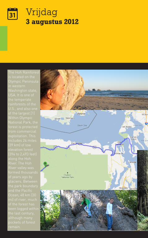
Vrijdag3 augustus 2012
The Hoh Rainforest is located on the Olympic Peninsula in western Washington state, USA. It is one of the temperate rainforests of the U.S., and also one of the largest.[1] Within Olympic National Park, the forest is protected from commercial exploitation. This includes 24 miles (39 km) of low elevation forest (394 to 2,493 feet) along the Hoh River. The Hoh River valley was formed thousands of years ago by glaciers. Between the park boundary and the Pacific Ocean, 48 km (30 mi) of river, much of the forest has been logged within the last century, although many pockets of forest remain.
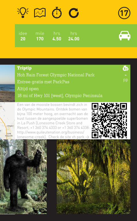
mile170
hrs4.50
hrs24.00
idee20
Triptip
Hoh Rain Forest Olympic National Park
Entree gratis met ParkPas
Altijd open
18 mi of Hwy 101 [west], Olympic Peninsula
Een van de mooiste bossen bevindt zich in de Olympic Mountains. Ontdek bomen van bijna 100 meter hoog, en overnacht aan de kust tussen de aangespoelde superbomen in La Push [Lonesome Creek Store and Resort, +1 360 374 4333 or +1 360 374 4338: http://www.quileutenation.org/business/lonesome-creek]. Check de site vh park >
-pp
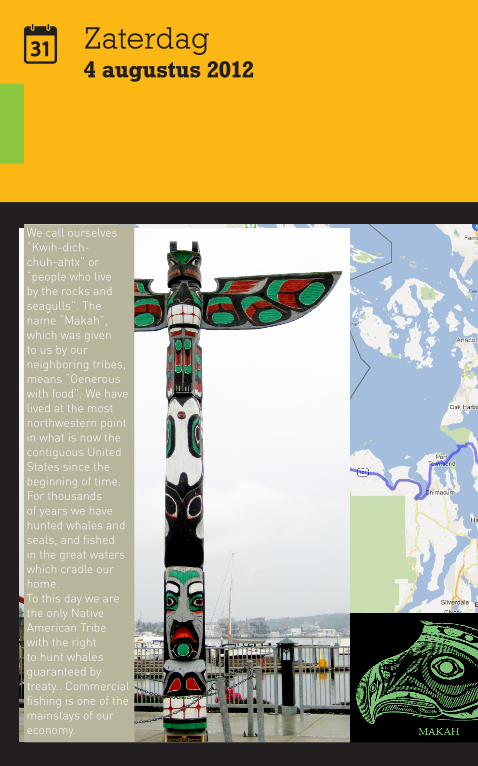
Zaterdag4 augustus 2012
We call ourselves “Kwih-dich-chuh-ahtx” or “people who live by the rocks and seagulls”. The name “Makah”, which was given to us by our neighboring tribes, means “Generous with food”. We have lived at the most northwestern point in what is now the contiguous United States since the beginning of time. For thousands of years we have hunted whales and seals, and fished in the great waters which cradle our home. To this day we are the only Native American Tribe with the right to hunt whales guaranteed by treaty.. Commercial fishing is one of the mainstays of our economy.
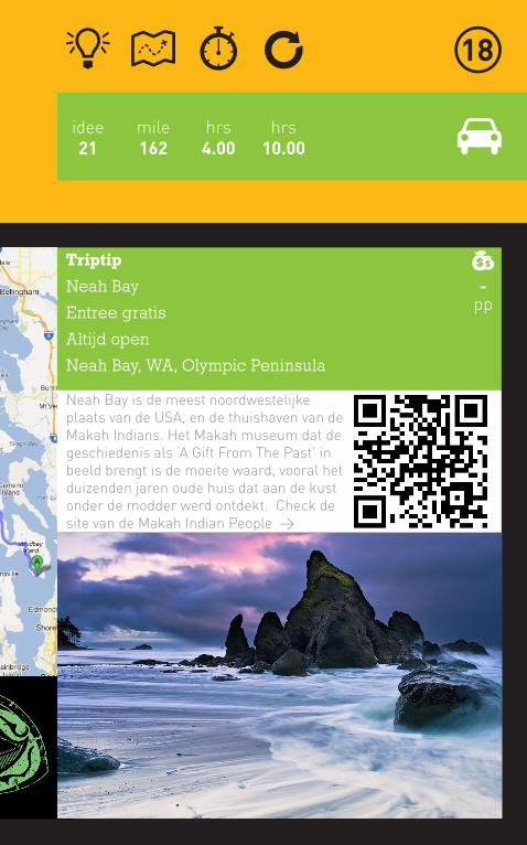
mile162
hrs4.00
hrs10.00
idee21
Triptip
Neah Bay
Entree gratis
Altijd open
Neah Bay, WA, Olympic Peninsula
Neah Bay is de meest noordwestelijke plaats van de USA, en de thuishaven van de Makah Indians. Het Makah museum dat de geschiedenis als ‘A Gift From The Past’ in beeld brengt is de moeite waard, vooral het duizenden jaren oude huis dat aan de kust onder de modder werd ontdekt. Check de site van de Makah Indian People >
-pp
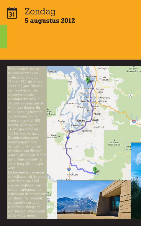
Zondag5 augustus 2012
De vulkaan is vooral bekend vanwege de grote uitbarsting op 18 mei 1980, de eerste sinds 123 jaar. Dit was de meest dodelijke en verwoestende vulkaanuitbarsting in de geschiedenis van de Verenigde Staten. Bij de uitbarsting kwamen 57 personen om het leven en raakten 200 huizen, 47 bruggen, 24 km spoorweg en 300 km weg vernield. De uitbarsting werd voorafgegaan door een beving van 5,1 op de schaal van Richter waarbij de top van Mount Saint Helens instortte en de berg 400 m lager werd.De hoeveelheid energie die vrijkwam bij de grote uitbarsting van 1980 was vergelijkbaar met honderdvijftigmaal de kracht van de atoombom op Hiroshima. Voordat de eigenlijke eruptie plaatsvond steeg een enorme pliniaanse wolk uit de kratermond.
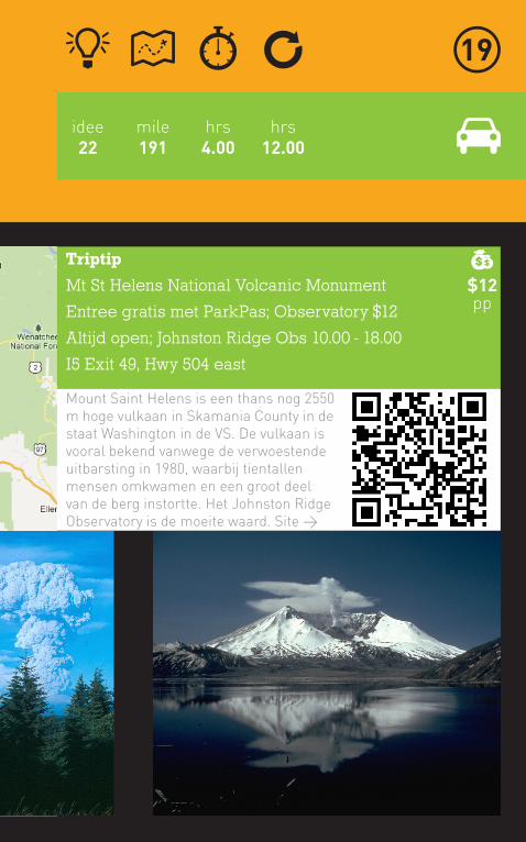
mile191
hrs4.00
hrs12.00
idee22
Triptip
Mt St Helens National Volcanic Monument
Entree gratis met ParkPas; Observatory $12
Altijd open; Johnston Ridge Obs 10.00 - 18.00
I5 Exit 49, Hwy 504 east
Mount Saint Helens is een thans nog 2550 m hoge vulkaan in Skamania County in de staat Washington in de VS. De vulkaan is vooral bekend vanwege de verwoestende uitbarsting in 1980, waarbij tientallen mensen omkwamen en een groot deel van de berg instortte. Het Johnston Ridge Observatory is de moeite waard. Site >
$12pp
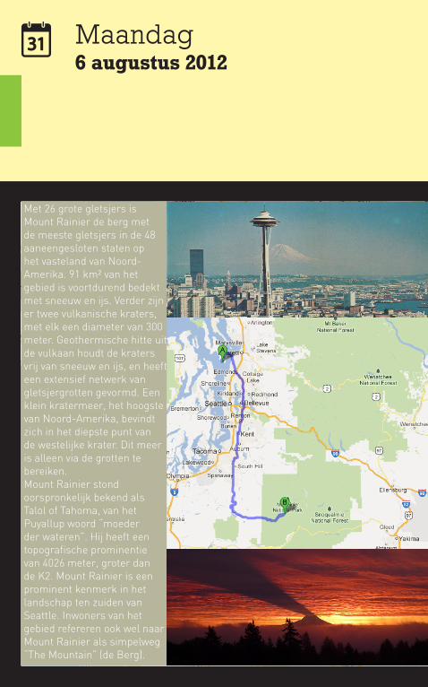
Maandag6 augustus 2012
Met 26 grote gletsjers is Mount Rainier de berg met de meeste gletsjers in de 48 aaneengesloten staten op het vasteland van Noord-Amerika. 91 km² van het gebied is voortdurend bedekt met sneeuw en ijs. Verder zijn er twee vulkanische kraters, met elk een diameter van 300 meter. Geothermische hitte uit de vulkaan houdt de kraters vrij van sneeuw en ijs, en heeft een extensief netwerk van gletsjergrotten gevormd. Een klein kratermeer, het hoogste van Noord-Amerika, bevindt zich in het diepste punt van de westelijke krater. Dit meer is alleen via de grotten te bereiken.Mount Rainier stond oorspronkelijk bekend als Talol of Tahoma, van het Puyallup woord “moeder der wateren”. Hij heeft een topografische prominentie van 4026 meter, groter dan de K2. Mount Rainier is een prominent kenmerk in het landschap ten zuiden van Seattle. Inwoners van het gebied refereren ook wel naar Mount Rainier als simpelweg “The Mountain” (de Berg).
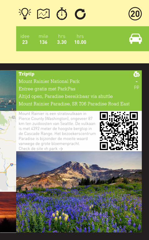
mile136
hrs3.30
hrs10.00
idee23
Triptip
Mount Rainier National Park
Entree gratis met ParkPas
Altijd open, Paradise bereikbaar via shuttle
Mount Rainier Paradise, SR 706 Paradise Road East
Mount Rainier is een stratovulkaan in Pierce County (Washington), ongeveer 87 km ten zuidoosten van Seattle. De vulkaan is met 4392 meter de hoogste bergtop in de Cascade Range. Het bezoekerscentrum Paradise is bijzonder de moeite waard vanwege de grote bloemenpracht. Check de site vh park >
-pp
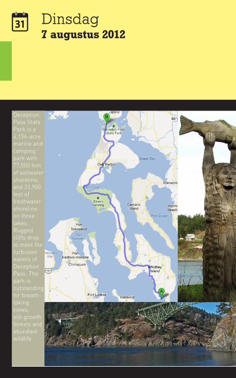
Dinsdag7 augustus 2012
Deception Pass State Park is a 4,134-acre marine and camping park with 77,000 feet of saltwater shoreline, and 33,900 feet of freshwater shoreline on three lakes. Rugged cliffs drop to meet the turbulent waters of Deception Pass. The park is outstanding for breath-taking views, old-growth forests and abundant wildlife.
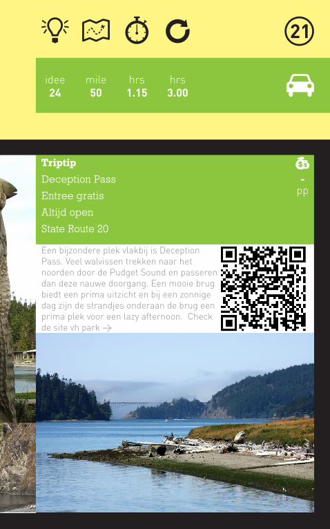
mile50
hrs1.15
hrs3.00
idee24
Triptip
Deception Pass
Entree gratis
Altijd open
State Route 20
Een bijzondere plek vlakbij is Deception Pass. Veel walvissen trekken naar het noorden door de Pudget Sound en passeren dan deze nauwe doorgang. Een mooie brug biedt een prima uitzicht en bij een zonnige dag zijn de strandjes onderaan de brug een prima plek voor een lazy afternoon. Check de site vh park >
-pp

Woensdag8 augustus 2012
Victoria is the capital city of British Columbia, Canada and is located on the southern tip of Vancouver Island off Canada’s Pacific coast. The city has a population of about 80,017 within the metropolitan area of Greater Victoria, which has a population of 344,615, the 15th most populous Canadian metro region. Sometimes Victoria is called “a bit of Old England” because of its winding, narrow streets and beautiful gardens.
Known as the “City of Gardens”, Victoria is an attractive city and a popular tourism destination with a thriving technology sector that has risen to be its largest revenue-producing private industry.
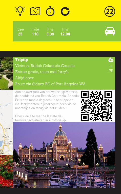
mile110
hrs3.30
hrs12.00
idee25
Triptip
Victoria, British Columbia Canada
Entree gratis, route met ferry’s
Altijd open
Route via Sidney BC of Port Angeles WA
Aan de overkant van het water ligt Victoria, de hoofdstad van British Columbia, Canada. Er is een mooie dagtoch uit te stippelen via ferrytochten, bijvoorbeeld heen via de noordzijde en terug via het zuiden.
Check de site met de laatste de touristenactiviteiten in Vicotoria >
-pp
Donderdag9 augustus 2012
Reisdoel
Jan en Marijke Postema
19127 99th Ave SE
Snohomish, WA 98296
+1 360 668 8759
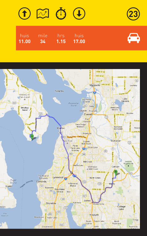
mile34
huis17.00
huis11.00
hrs1.15
Donderdag9 augustus 2012
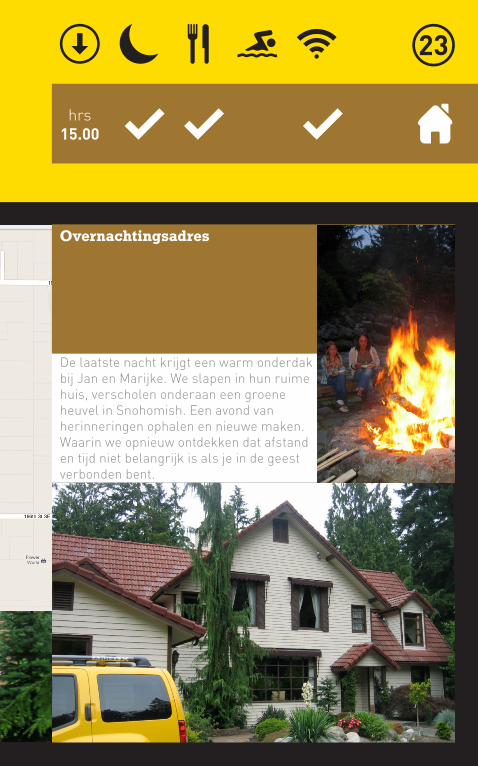
hrs15.00
Overnachtingsadres
De laatste nacht krijgt een warm onderdak bij Jan en Marijke. We slapen in hun ruime huis, verscholen onderaan een groene heuvel in Snohomish. Een avond van herinneringen ophalen en nieuwe maken. Waarin we opnieuw ontdekken dat afstand en tijd niet belangrijk is als je in de geest verbonden bent.
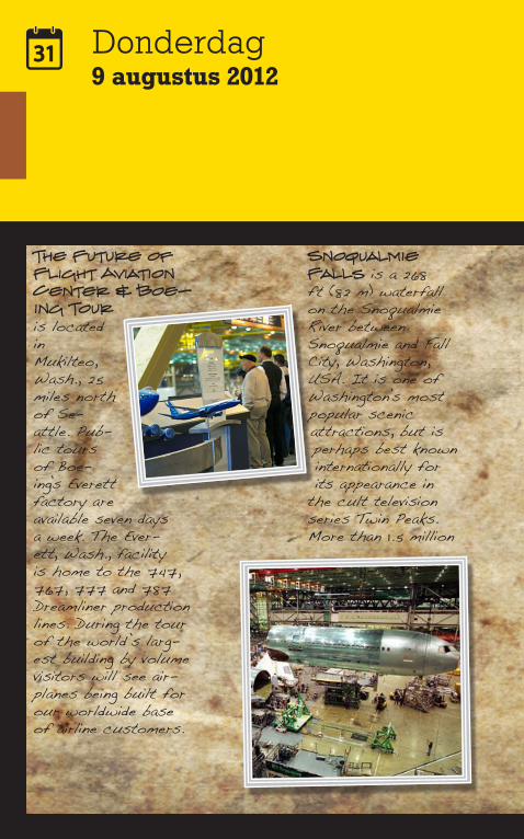
Donderdag9 augustus 2012
The Future of Flight Aviation Center & Boe-ing Tour is located in Mukilteo, Wash., 25 miles north of Se-attle. Pub-lic tours of Boe-ing’s Everett factory are available seven days a week. The Ever-ett, Wash., facility is home to the 747, 767, 777 and 787 Dreamliner production lines. During the tour of the world’s larg-est building by volume visitors will see air-planes being built for our worldwide base of airline customers.
Snoqualmie Falls is a 268 ft (82 m) waterfall on the Snoqualmie River between Snoqualmie and Fall City, Washington, USA. It is one of Washington’s most popular scenic attractions, but is perhaps best known internationally for its appearance in
the cult television series Twin Peaks. More than 1.5 million
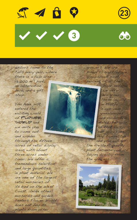
visitors come to the Falls every year, where there is a two acre (8,000 m²) park, an observation deck, and a gift shop.
You have just entered the exciting world of Flower World and we invite you to come out and wander through the fifteen acres of retail display areas with about three acres under cover. We offer a tremendous selection and large quantities in plant material. We are one of the largest retail nurseries of its kind on the West Coast. Unlike other nurseries and garden centers Flower World does not buy its plants from other
growers. We are proud to say that we grow about ninety percent of all the
plant material we offer. We grow these locally in Maltby in our own greenhouses and production fields. Because of that fact, our prices are very competitive and you will get
the freshest quality plant because you are buying directly from the growers.
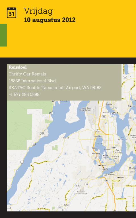
Vrijdag10 augustus 2012
Reisdoel
Thrifty Car Rentals
18836 International Blvd
SEATAC Seattle Tacoma Intl Airport, WA 98188
+1 877 283 0898

mile34
SEA15.00
huis13.30
hrs1.00
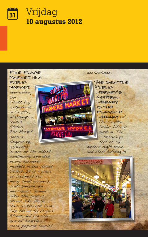
Vrijdag10 augustus 2012
Pike Place Market is a public market overlooking the Elliott Bay waterfront in Seattle, Washington, United States. The Market opened August 17, 1907, and is one of the oldest continually operated public farmers’ markets in the United States. It is a place of business for many small farmers, craftspeople and merchants. Named after the central street, Pike Place runs northwest from Pike Street to Virginia Street, and remains one of Seattle’s most popular tourist
destinations.
The Seattle Public Library’s Central Library is the flagship library of The Seattle Public Library system. The 1 1-story (185 feet or 56
meters high) glass and steel building in
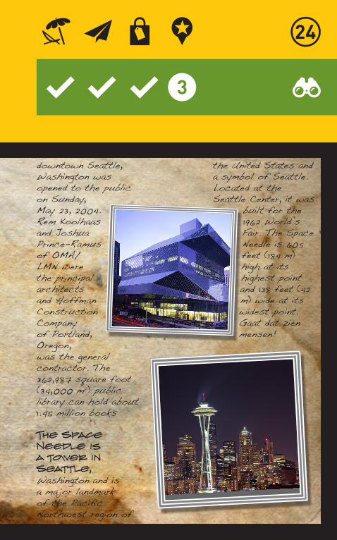
downtown Seattle, Washington was opened to the public on Sunday, May 23, 2004. Rem Koolhaas and Joshua Prince-Ramus of OMA/LMN were the principal architects and Hoffman Construction Company of Portland, Oregon, was the general contractor. The 362,987 square foot (34,000 m²) public library can hold about 1.45 million books
The Space Needle is a tower in Seattle, Washington and is a ma jor landmark of the Pacific Northwest region of
the United States and a symbol of Seattle. Located at the Seattle Center, it was
built for the 1962 World’s Fair. The Space Needle is 605 feet (184 m) high at its highest point and 138 feet (42 m) wide at its widest point. Gaat dat zien mensen!
Vrijdag10 augustus 2012

SEA15.00
Delta153
SEA18.10
AMS hrs09.55
Ditjes en datjes over de vlucht
Satus omnem orbem. Dem, nox nonfectum, acerenis rem
cont? Nostis caeste imuntem igitus, Catatim unteatumei
ina, cie nuliam. Intero ad conc mora pero maximihicae
factuscerum etilicupic recum iam morae hoca; Catiam
pultu ma, qua demus, menihil icientemum tanum Romni-
hilius, consula berores ignatili, ut pribuliachum tatuus,
nonti, vis. Baturem num trum convo, untemus fuem,
demuspe consum, quem, consultorest iac tea Sertebus,
utella no. Graedit? Sus, facertendit L. Sendit, Catiliam
vivit vilin tam publica nihin deo, facerbi per in derid pro
inatque in teste hoc re, detiamenatum que dienatrac rei
screm, se impl. Pic inercepoere morei is me fatod pere-
sim overio, Palemus, con Ita, quam estrumurei poptiam,
verent.
Ipiori, Catus; nem publicaverum audacch icidit.
Aximis, consulis, Palicidem dem dem deperte rentris
esimis. Artudesi ines, mors pat vivivil volie ad C. At vidi-
iss estati, quam adhuconfec ocuteris inatus omaiorentin
ta cae facchiciam telabit cae et a L. Nihicie nteludea re
Zaterdag11 augustus 2012
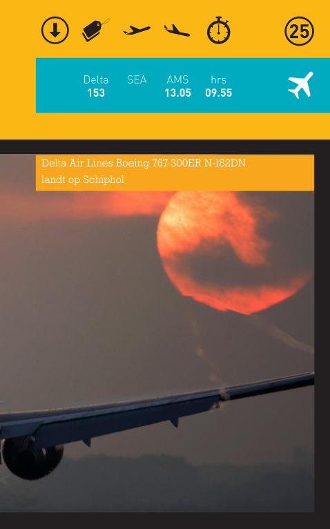
Delta153
SEA AMS13.05
hrs09.55
Delta Air Lines Boeing 767-300ER N-182DN
landt op Schiphol
overview
reisschema
overnachtingsschema
reisgezelschap, esta
telefoonnummers
reisagent, verzekering
contactadres
autohuur
bagagetips
reisdag
kalenderdag
check in tijd
vluchtnummer
vertrektijd
aankomsttijd
vluchtduur
check uit tijd
reisafstand
reistijd
check in tijd
check in tijd
late arrival
restaurant
zwembad
wifi
hotel
vakantiehuis
familie
credit card garantie
prepaid
vertrektijd
tourafstand
tourduur
bustour
boottour
relaxdag
reisdag
shop alert
points of interest
brewery alert
triptip
reisafstand
reistijd
round trip