Portfolio landschapsarchitectuur Lucia van der Lee
28
Lucia van der Lee Portfolio landschapsarchitectuur
-
Upload
lucia-van-der-lee -
Category
Documents
-
view
234 -
download
0
description
Â
Transcript of Portfolio landschapsarchitectuur Lucia van der Lee
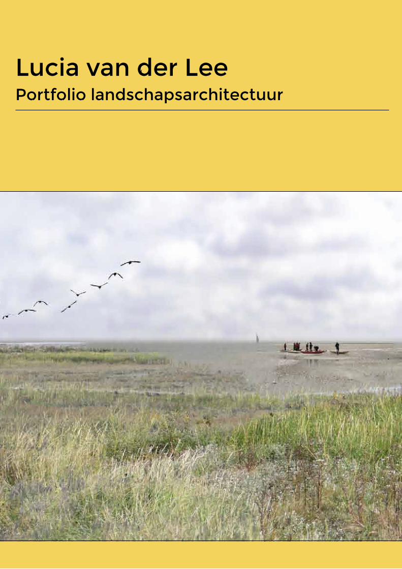
Lucia van der Lee Portfolio landschapsarchitectuur
Unique accessible salt marsh landscape
1. Natuurlijke en culturele kwaliteiten als basis voor ontwikkelingen recreatie en toerisme
2. Beleving natuurlijke en culturele kwaliteiten is mogelijk
3. Zorgvuldig gebruik van natuurlijke hulpbronnen
4. Verantwoorde en interactieve planprocessen
5. Ontwikkeling van recreatie en toerisme in samenhang met bredere context
8
5
5
2
3
Cluster Aantal principes
1. Natural and cultural qualities serve as basis for
recreation and tourism
2. Experience of natural and cultural qualities is possible
3. Careful use of natural sources
4. Responsible and interactive planning
processes
5. Development of recreation and tourism are consistent
with the wider context
Vision
Wad
den
dyke
land
Total
num
ber o
f prin
ciples
Area
Zur
ich-H
arlin
gen
Area
Oos
terbie
rum
and
surro
undin
gs
Zuric
h-Har
linge
n|Cro
ssing
N31
Zuric
h-Har
linge
n|Po
lder Z
urich
eroo
rd
Zuric
h-Har
linge
n|En
tranc
e of Z
urich
Oos
terbie
rum
and
surro
undin
gs|S
alt m
arsh
Total
num
ber o
f diffe
rent
princ
iples
in de
signs
Plan Fryslân aan zee
(Atelier Fryslân, 2012)
Totaal Waddendijkland
totaal
Indication high tide line
Zone nature
Zone recreation
Camping with tent allowed1 2 km
Sustainable recreation and tourism can be viewed from different perspectives. In this study, sustainable recreation and tourism is looked at as forms of recreation and tourism that contribute to the sustainable development of a geographical region (Telfer & Sharpley, 2008). Sustainability is a broad concept; to make it more concrete, oftentimes certain principles are applied. (Hunter,1997; Tanguay & Rajaonson, 2013). Landscape architecture has not yet formulated an answer to the questions what constitutes sustainable recreation and tourism, but some of the principles used in this quest have spatial relevance (GSTC, 2013; EUROPARC Federation, 2010). As a result of this, they could be applied in the design of a landscape. Examples for this use are as of yet non-existent.
The purpose of this study was to provide some insight in the possible ways a landscape can be designed for recreation and tourism, so that recreation and tourism contributes to the sustainable development of a region, by using these spatially relevant principles. The case of the Frisian wadden coast is used to illustrate this.
The spatially relevant principles appear to be applied at different scales and steps in the landscape design. The number of principles used roughly increases at designs with lower scale levels. The spatially relevant principles don’t cause a landscape plan to evolve automatically. It is necessary to enter the activity of designing and to set the design assignment and to use appropriate design principles.
Spatially relevant principles for sustainable recreation and tourism
Supporting
Profiting
Recreation and tourism
Andere ontwikkelingen
Relation recreation & tourism and other developments when it con-tributes to the sustainable development of a region.
Experiencing the starry sky in the salt marsh
1. N
atuu
rlijk
e en
cul
ture
le k
wal
iteite
n al
s ba
sis
voor
ont
wik
kelin
gen
recr
eatie
en
toer
ism
e
2. B
elev
ing
natu
urlij
ke e
n cu
lture
le k
wal
iteite
n is
mog
elijk
3. Z
orgv
uldi
g ge
brui
k va
n na
tuur
lijke
hu
lpbr
onne
n
4. V
eran
twoo
rde
en in
tera
ctie
ve p
lanp
roce
ssen
5. O
ntw
ikke
ling
van
recr
eatie
en
toer
ism
e in
sa
men
hang
met
bre
dere
con
text
8
5 5
2
3
Clu
ster
Aan
tal p
rinci
pes
1. N
atuu
rlijk
e en
cul
ture
le
kwal
iteite
n al
s ba
sis
voor
on
twik
kelin
gen
recr
eatie
en
toer
ism
e
2. B
elev
ing
natu
urlij
ke e
n cu
lture
le k
wal
iteite
n is
mog
elijk
3. Z
orgv
uldi
g ge
brui
k va
n na
tuur
lijke
hu
lpbr
onne
n
4. V
eran
twoo
rde
en
inte
ract
ieve
pla
npro
cess
en
5. O
ntw
ikke
ling
van
recr
eatie
en
toer
ism
e in
sam
enha
ng
met
bre
dere
con
text
Visie
Wad
dend
ijklan
d
Totaa
l aan
tal p
rincip
es
Deelge
bied
Zuric
h-Har
linge
n
Deelge
bied
Oos
terbie
rum
en o
mge
ving
Zuric
h-Har
linge
n|O
verst
eek N
31
Zuric
h-Har
linge
n|Po
lder Z
urich
eroo
rd
Zuric
h-Har
linge
n|En
tree Z
urich
Oos
terbie
rum
en o
mge
ving|
Kweld
er
Totaa
l aan
tal ve
rschil
lende
prin
cipes
in on
twer
pen
Plan
Frysl
ân a
an ze
e
(Atel
ier Fr
yslân
, 201
2)
Totaa
l Wad
dend
ijklan
d
totaal
Liveability local community
Climate change
Coherence spatial developmentsDevelopment strategy for recration and tourismInvolvement of stakeholders
Diminishing pollution, waste by recreationCareful watermanagement
Effective usage of natural sourcesEco-friendly transport
Placement of touristic developmentsDisabled visitors
Information/educational facilitiesParticipation of visitors
Experience of visitors
Discovery of destination
Style of touristic developmentsLocal history
Local entrepeneurs
Special places accessible
Protection of natural and cultural qualitiesIntangible qualities
Protection of vulnerable areasAttractions with natural or cultural value
Oosterbierum and surroundings
New salt marsh Oosterbierum
New salt marsh Oosterbierum
New salt marsh Oosterbierum
1 2 3
5
4
4
5
5
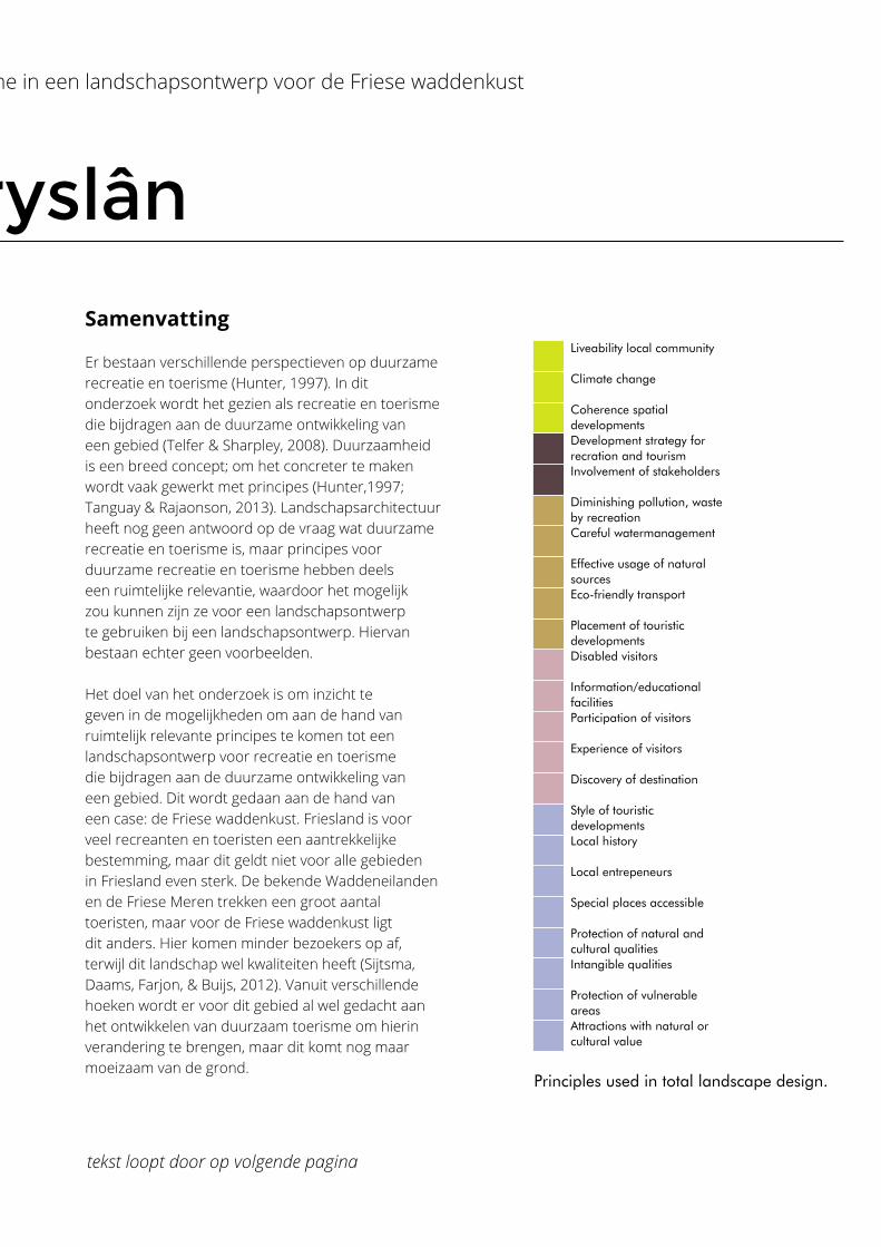
Principles used in total landscape design. Number of principles used increases roughly at lower scale levels.
Current
Current
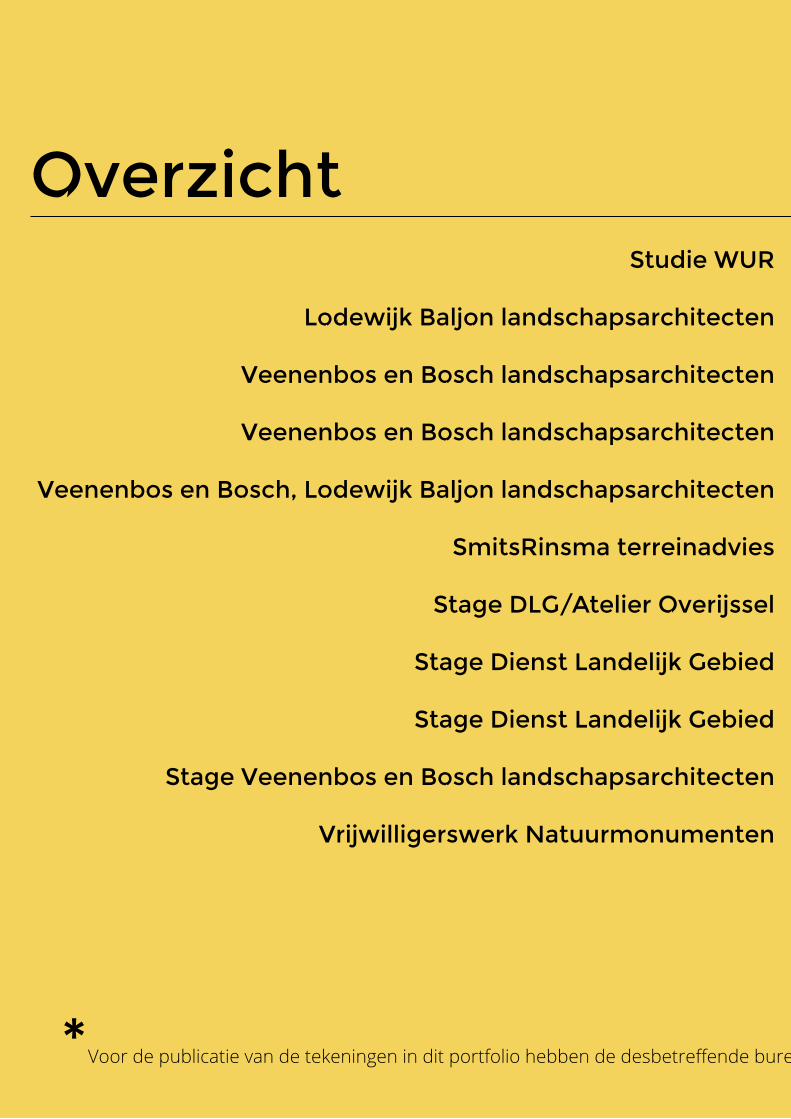
Studie WUR
Lodewijk Baljon landschapsarchitecten
Veenenbos en Bosch landschapsarchitecten
Veenenbos en Bosch landschapsarchitecten
Veenenbos en Bosch, Lodewijk Baljon landschapsarchitecten
SmitsRinsma terreinadvies
Stage DLG/Atelier Overijssel
Stage Dienst Landelijk Gebied
Stage Dienst Landelijk Gebied
Stage Veenenbos en Bosch landschapsarchitecten
Vrijwilligerswerk Natuurmonumenten
Overzicht
*Voor de publicatie van de tekeningen in dit portfolio hebben de desbetreffende bureaus hun toestemming gegeven. De tekeningen zijn door mij gemaakt.
Waddendijkland voor FryslânEnka boswonen, EdeGebiedsvisie Apeldoorns KanaalOnderzoek straatprofielen Diverse VO’s en DO’sPaleistuinLandschapsadvies Atelier OverijsselBeschutting OostvaardersplassenNatuurontwikkeling WinterswijkDe Wheme, Arnhem Poëzieroute Zuidwest Veluwe
Overzicht
*Voor de publicatie van de tekeningen in dit portfolio hebben de desbetreffende bureaus hun toestemming gegeven. De tekeningen zijn door mij gemaakt.
New recreational activities and facilities
Sailing connection Wadden Sea and Friesland
Dyke as guiding structure
Existing recreational activities and facilities
Area Zurich-Harlingen
Area Oosterbierum and surroundings
10 20 km
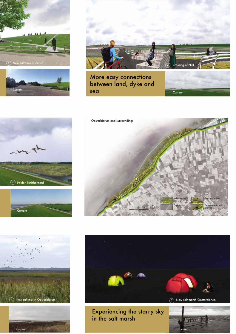
More easy connections between land, dyke and sea
Vision Wadden dyke land
More attractive centre points for visitors and inhabitants
1 2 km
Village/city
Dyke
Road
Water
Grassland
Arable land
Saline agriculture
Legend
Existing bicycle route
New bicycle route
Dyke water strorage zone
Mudflat walking and sailing
Existing facility/activity
New facility/activity
Recreational route on dyke
Nature
Sailing routes
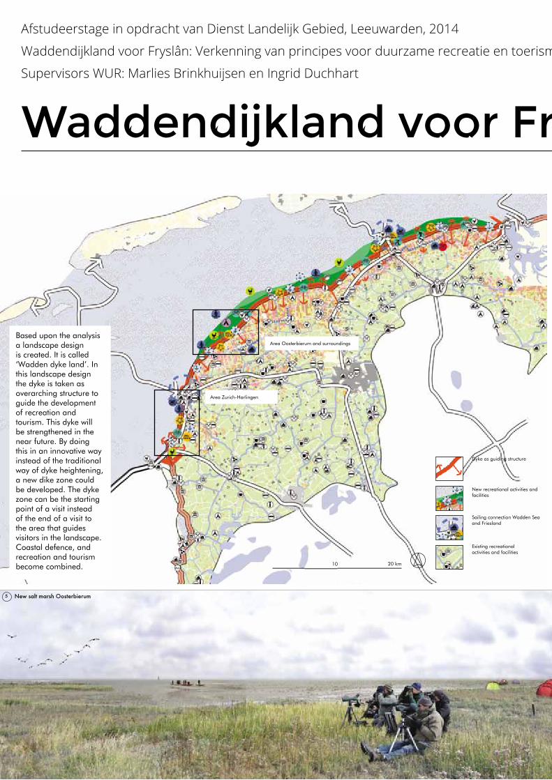
Based upon the analysis a landscape design is created. It is called ‘Wadden dyke land’. In this landscape design the dyke is taken as overarching structure to guide the development of recreation and tourism. This dyke will be strengthened in the near future. By doing this in an innovative way instead of the traditional way of dyke heightening, a new dike zone could be developed. The dyke zone can be the starting point of a visit instead of the end of a visit to the area that guides visitors in the landscape. Coastal defence, and recreation and tourism become combined.
Recreational activities can be expanded around the dyke, for example by new routes on the dyke and in the new salt marshes, with new centre points, birds, saline agriculture and art projects. Cities and villages can support visitors
to the dyke zone by providing a sufficient facility network for nourishment and accommodation. In this way the area will attract visitors based upon its natural and cultural qualities. For Zurich-Harlingen the concept of the overtopping dyke is
chosen. This allows the dynamics of the sea to be present on the land side of the dyke as well. This will create more possibilities to expierence this natural quality of the area and to attract visitors by this.
Dyke as guiding structure through the landscape
Area of Zurich-Harlingen
New entrance of Zurich Crossing of N31 Polder Zuricheroord
1 32
1
2
3
321
Current CurrentCurrent
Unique accessible salt marsh landscape
1. Natuurlijke en culturele kwaliteiten als basis voor ontwikkelingen recreatie en toerisme
2. Beleving natuurlijke en culturele kwaliteiten is mogelijk
3. Zorgvuldig gebruik van natuurlijke hulpbronnen
4. Verantwoorde en interactieve planprocessen
5. Ontwikkeling van recreatie en toerisme in samenhang met bredere context
8
5
5
2
3
Cluster Aantal principes
1. Natural and cultural qualities serve as basis for
recreation and tourism
2. Experience of natural and cultural qualities is possible
3. Careful use of natural sources
4. Responsible and interactive planning
processes
5. Development of recreation and tourism are consistent
with the wider context
Vision
Wad
den
dyke
land
Total
num
ber o
f prin
ciples
Area
Zur
ich-H
arlin
gen
Area
Oos
terbie
rum
and
surro
undin
gs
Zuric
h-Har
linge
n|Cro
ssing
N31
Zuric
h-Har
linge
n|Po
lder Z
urich
eroo
rd
Zuric
h-Har
linge
n|En
tranc
e of Z
urich
Oos
terbie
rum
and
surro
undin
gs|S
alt m
arsh
Total
num
ber o
f diffe
rent
princ
iples
in de
signs
Plan Fryslân aan zee
(Atelier Fryslân, 2012)
Totaal Waddendijkland
totaal
Indication high tide line
Zone nature
Zone recreation
Camping with tent allowed1 2 km
Sustainable recreation and tourism can be viewed from different perspectives. In this study, sustainable recreation and tourism is looked at as forms of recreation and tourism that contribute to the sustainable development of a geographical region (Telfer & Sharpley, 2008). Sustainability is a broad concept; to make it more concrete, oftentimes certain principles are applied. (Hunter,1997; Tanguay & Rajaonson, 2013). Landscape architecture has not yet formulated an answer to the questions what constitutes sustainable recreation and tourism, but some of the principles used in this quest have spatial relevance (GSTC, 2013; EUROPARC Federation, 2010). As a result of this, they could be applied in the design of a landscape. Examples for this use are as of yet non-existent.
The purpose of this study was to provide some insight in the possible ways a landscape can be designed for recreation and tourism, so that recreation and tourism contributes to the sustainable development of a region, by using these spatially relevant principles. The case of the Frisian wadden coast is used to illustrate this.
The spatially relevant principles appear to be applied at different scales and steps in the landscape design. The number of principles used roughly increases at designs with lower scale levels. The spatially relevant principles don’t cause a landscape plan to evolve automatically. It is necessary to enter the activity of designing and to set the design assignment and to use appropriate design principles.
Spatially relevant principles for sustainable recreation and tourism
Supporting
Profiting
Recreation and tourism
Andere ontwikkelingen
Relation recreation & tourism and other developments when it con-tributes to the sustainable development of a region.
Experiencing the starry sky in the salt marsh
1. N
atuu
rlijk
e en
cul
ture
le k
wal
iteite
n al
s ba
sis
voor
ont
wik
kelin
gen
recr
eatie
en
toer
ism
e
2. B
elev
ing
natu
urlij
ke e
n cu
lture
le k
wal
iteite
n is
mog
elijk
3. Z
orgv
uldi
g ge
brui
k va
n na
tuur
lijke
hu
lpbr
onne
n
4. V
eran
twoo
rde
en in
tera
ctie
ve p
lanp
roce
ssen
5. O
ntw
ikke
ling
van
recr
eatie
en
toer
ism
e in
sa
men
hang
met
bre
dere
con
text
8
5 5
2
3
Clu
ster
Aan
tal p
rinci
pes
1. N
atuu
rlijk
e en
cul
ture
le
kwal
iteite
n al
s ba
sis
voor
on
twik
kelin
gen
recr
eatie
en
toer
ism
e
2. B
elev
ing
natu
urlij
ke e
n cu
lture
le k
wal
iteite
n is
mog
elijk
3. Z
orgv
uldi
g ge
brui
k va
n na
tuur
lijke
hu
lpbr
onne
n
4. V
eran
twoo
rde
en
inte
ract
ieve
pla
npro
cess
en
5. O
ntw
ikke
ling
van
recr
eatie
en
toer
ism
e in
sam
enha
ng
met
bre
dere
con
text
Visie
Wad
dend
ijklan
d
Totaa
l aan
tal p
rincip
es
Deelge
bied
Zuric
h-Har
linge
n
Deelge
bied
Oos
terbie
rum
en o
mge
ving
Zuric
h-Har
linge
n|O
verst
eek N
31
Zuric
h-Har
linge
n|Po
lder Z
urich
eroo
rd
Zuric
h-Har
linge
n|En
tree Z
urich
Oos
terbie
rum
en o
mge
ving|
Kweld
er
Totaa
l aan
tal ve
rschil
lende
prin
cipes
in on
twer
pen
Plan
Frysl
ân a
an ze
e
(Atel
ier Fr
yslân
, 201
2)
Totaa
l Wad
dend
ijklan
d
totaal
Liveability local community
Climate change
Coherence spatial developmentsDevelopment strategy for recration and tourismInvolvement of stakeholders
Diminishing pollution, waste by recreationCareful watermanagement
Effective usage of natural sourcesEco-friendly transport
Placement of touristic developmentsDisabled visitors
Information/educational facilitiesParticipation of visitors
Experience of visitors
Discovery of destination
Style of touristic developmentsLocal history
Local entrepeneurs
Special places accessible
Protection of natural and cultural qualitiesIntangible qualities
Protection of vulnerable areasAttractions with natural or cultural value
Oosterbierum and surroundings
New salt marsh Oosterbierum
New salt marsh Oosterbierum
New salt marsh Oosterbierum
1 2 3
5
4
4
5
5
Principles used in total landscape design. Number of principles used increases roughly at lower scale levels.
Current
Current
Waddendijkland voor Fryslân
Afstudeerstage in opdracht van Dienst Landelijk Gebied, Leeuwarden, 2014
Waddendijkland voor Fryslân: Verkenning van principes voor duurzame recreatie en toerisme in een landschapsontwerp voor de Friese waddenkust
Supervisors WUR: Marlies Brinkhuijsen en Ingrid Duchhart
New recreational activities and facilities
Sailing connection Wadden Sea and Friesland
Dyke as guiding structure
Existing recreational activities and facilities
Area Zurich-Harlingen
Area Oosterbierum and surroundings
10 20 km
More easy connections between land, dyke and sea
Vision Wadden dyke land
More attractive centre points for visitors and inhabitants
1 2 km
Village/city
Dyke
Road
Water
Grassland
Arable land
Saline agriculture
Legend
Existing bicycle route
New bicycle route
Dyke water strorage zone
Mudflat walking and sailing
Existing facility/activity
New facility/activity
Recreational route on dyke
Nature
Sailing routes
Based upon the analysis a landscape design is created. It is called ‘Wadden dyke land’. In this landscape design the dyke is taken as overarching structure to guide the development of recreation and tourism. This dyke will be strengthened in the near future. By doing this in an innovative way instead of the traditional way of dyke heightening, a new dike zone could be developed. The dyke zone can be the starting point of a visit instead of the end of a visit to the area that guides visitors in the landscape. Coastal defence, and recreation and tourism become combined.
Recreational activities can be expanded around the dyke, for example by new routes on the dyke and in the new salt marshes, with new centre points, birds, saline agriculture and art projects. Cities and villages can support visitors
to the dyke zone by providing a sufficient facility network for nourishment and accommodation. In this way the area will attract visitors based upon its natural and cultural qualities. For Zurich-Harlingen the concept of the overtopping dyke is
chosen. This allows the dynamics of the sea to be present on the land side of the dyke as well. This will create more possibilities to expierence this natural quality of the area and to attract visitors by this.
Dyke as guiding structure through the landscape
Area of Zurich-Harlingen
New entrance of Zurich Crossing of N31 Polder Zuricheroord
1 32
1
2
3
321
Current CurrentCurrent
Unique accessible salt marsh landscape
1. Natuurlijke en culturele kwaliteiten als basis voor ontwikkelingen recreatie en toerisme
2. Beleving natuurlijke en culturele kwaliteiten is mogelijk
3. Zorgvuldig gebruik van natuurlijke hulpbronnen
4. Verantwoorde en interactieve planprocessen
5. Ontwikkeling van recreatie en toerisme in samenhang met bredere context
8
5
5
2
3
Cluster Aantal principes
1. Natural and cultural qualities serve as basis for
recreation and tourism
2. Experience of natural and cultural qualities is possible
3. Careful use of natural sources
4. Responsible and interactive planning
processes
5. Development of recreation and tourism are consistent
with the wider context
Vision
Wad
den
dyke
land
Total
num
ber o
f prin
ciples
Area
Zur
ich-H
arlin
gen
Area
Oos
terbie
rum
and
surro
undin
gs
Zuric
h-Har
linge
n|Cro
ssing
N31
Zuric
h-Har
linge
n|Po
lder Z
urich
eroo
rd
Zuric
h-Har
linge
n|En
tranc
e of Z
urich
Oos
terbie
rum
and
surro
undin
gs|S
alt m
arsh
Total
num
ber o
f diffe
rent
princ
iples
in de
signs
Plan Fryslân aan zee
(Atelier Fryslân, 2012)
Totaal Waddendijkland
totaal
Indication high tide line
Zone nature
Zone recreation
Camping with tent allowed1 2 km
Sustainable recreation and tourism can be viewed from different perspectives. In this study, sustainable recreation and tourism is looked at as forms of recreation and tourism that contribute to the sustainable development of a geographical region (Telfer & Sharpley, 2008). Sustainability is a broad concept; to make it more concrete, oftentimes certain principles are applied. (Hunter,1997; Tanguay & Rajaonson, 2013). Landscape architecture has not yet formulated an answer to the questions what constitutes sustainable recreation and tourism, but some of the principles used in this quest have spatial relevance (GSTC, 2013; EUROPARC Federation, 2010). As a result of this, they could be applied in the design of a landscape. Examples for this use are as of yet non-existent.
The purpose of this study was to provide some insight in the possible ways a landscape can be designed for recreation and tourism, so that recreation and tourism contributes to the sustainable development of a region, by using these spatially relevant principles. The case of the Frisian wadden coast is used to illustrate this.
The spatially relevant principles appear to be applied at different scales and steps in the landscape design. The number of principles used roughly increases at designs with lower scale levels. The spatially relevant principles don’t cause a landscape plan to evolve automatically. It is necessary to enter the activity of designing and to set the design assignment and to use appropriate design principles.
Spatially relevant principles for sustainable recreation and tourism
Supporting
Profiting
Recreation and tourism
Andere ontwikkelingen
Relation recreation & tourism and other developments when it con-tributes to the sustainable development of a region.
Experiencing the starry sky in the salt marsh
1. N
atuu
rlijk
e en
cul
ture
le k
wal
iteite
n al
s ba
sis
voor
ont
wik
kelin
gen
recr
eatie
en
toer
ism
e
2. B
elev
ing
natu
urlij
ke e
n cu
lture
le k
wal
iteite
n is
mog
elijk
3. Z
orgv
uldi
g ge
brui
k va
n na
tuur
lijke
hu
lpbr
onne
n
4. V
eran
twoo
rde
en in
tera
ctie
ve p
lanp
roce
ssen
5. O
ntw
ikke
ling
van
recr
eatie
en
toer
ism
e in
sa
men
hang
met
bre
dere
con
text
8
5 5
2
3
Clu
ster
Aan
tal p
rinci
pes
1. N
atuu
rlijk
e en
cul
ture
le
kwal
iteite
n al
s ba
sis
voor
on
twik
kelin
gen
recr
eatie
en
toer
ism
e
2. B
elev
ing
natu
urlij
ke e
n cu
lture
le k
wal
iteite
n is
mog
elijk
3. Z
orgv
uldi
g ge
brui
k va
n na
tuur
lijke
hu
lpbr
onne
n
4. V
eran
twoo
rde
en
inte
ract
ieve
pla
npro
cess
en
5. O
ntw
ikke
ling
van
recr
eatie
en
toer
ism
e in
sam
enha
ng
met
bre
dere
con
text
Visie
Wad
dend
ijklan
d
Totaa
l aan
tal p
rincip
es
Deelge
bied
Zuric
h-Har
linge
n
Deelge
bied
Oos
terbie
rum
en o
mge
ving
Zuric
h-Har
linge
n|O
verst
eek N
31
Zuric
h-Har
linge
n|Po
lder Z
urich
eroo
rd
Zuric
h-Har
linge
n|En
tree Z
urich
Oos
terbie
rum
en o
mge
ving|
Kweld
er
Totaa
l aan
tal ve
rschil
lende
prin
cipes
in on
twer
pen
Plan
Frysl
ân a
an ze
e
(Atel
ier Fr
yslân
, 201
2)
Totaa
l Wad
dend
ijklan
d
totaal
Liveability local community
Climate change
Coherence spatial developmentsDevelopment strategy for recration and tourismInvolvement of stakeholders
Diminishing pollution, waste by recreationCareful watermanagement
Effective usage of natural sourcesEco-friendly transport
Placement of touristic developmentsDisabled visitors
Information/educational facilitiesParticipation of visitors
Experience of visitors
Discovery of destination
Style of touristic developmentsLocal history
Local entrepeneurs
Special places accessible
Protection of natural and cultural qualitiesIntangible qualities
Protection of vulnerable areasAttractions with natural or cultural value
Oosterbierum and surroundings
New salt marsh Oosterbierum
New salt marsh Oosterbierum
New salt marsh Oosterbierum
1 2 3
5
4
4
5
5
Principles used in total landscape design. Number of principles used increases roughly at lower scale levels.
Current
Current
Waddendijkland voor Fryslân
Afstudeerstage in opdracht van Dienst Landelijk Gebied, Leeuwarden, 2014
Waddendijkland voor Fryslân: Verkenning van principes voor duurzame recreatie en toerisme in een landschapsontwerp voor de Friese waddenkust
Supervisors WUR: Marlies Brinkhuijsen en Ingrid Duchhart
Samenvatting
Er bestaan verschillende perspectieven op duurzame recreatie en toerisme (Hunter, 1997). In dit onderzoek wordt het gezien als recreatie en toerisme die bijdragen aan de duurzame ontwikkeling van een gebied (Telfer & Sharpley, 2008). Duurzaamheid is een breed concept; om het concreter te maken wordt vaak gewerkt met principes (Hunter,1997; Tanguay & Rajaonson, 2013). Landschapsarchitectuur heeft nog geen antwoord op de vraag wat duurzame recreatie en toerisme is, maar principes voor duurzame recreatie en toerisme hebben deels een ruimtelijke relevantie, waardoor het mogelijk zou kunnen zijn ze voor een landschapsontwerp te gebruiken bij een landschapsontwerp. Hiervan bestaan echter geen voorbeelden.
Het doel van het onderzoek is om inzicht te geven in de mogelijkheden om aan de hand van ruimtelijk relevante principes te komen tot een landschapsontwerp voor recreatie en toerisme die bijdragen aan de duurzame ontwikkeling van een gebied. Dit wordt gedaan aan de hand van een case: de Friese waddenkust. Friesland is voor veel recreanten en toeristen een aantrekkelijke bestemming, maar dit geldt niet voor alle gebieden in Friesland even sterk. De bekende Waddeneilanden en de Friese Meren trekken een groot aantal toeristen, maar voor de Friese waddenkust ligt dit anders. Hier komen minder bezoekers op af, terwijl dit landschap wel kwaliteiten heeft (Sijtsma, Daams, Farjon, & Buijs, 2012). Vanuit verschillende hoeken wordt er voor dit gebied al wel gedacht aan het ontwikkelen van duurzaam toerisme om hierin verandering te brengen, maar dit komt nog maar moeizaam van de grond.
Unique accessible salt marsh landscape
1. Natuurlijke en culturele kwaliteiten als basis voor ontwikkelingen recreatie en toerisme
2. Beleving natuurlijke en culturele kwaliteiten is mogelijk
3. Zorgvuldig gebruik van natuurlijke hulpbronnen
4. Verantwoorde en interactieve planprocessen
5. Ontwikkeling van recreatie en toerisme in samenhang met bredere context
8
5
5
2
3
Cluster Aantal principes
1. Natural and cultural qualities serve as basis for
recreation and tourism
2. Experience of natural and cultural qualities is possible
3. Careful use of natural sources
4. Responsible and interactive planning
processes
5. Development of recreation and tourism are consistent
with the wider context
Vision
Wad
den
dyke
land
Total
num
ber o
f prin
ciples
Area
Zur
ich-H
arlin
gen
Area
Oos
terbie
rum
and
surro
undin
gs
Zuric
h-Har
linge
n|Cro
ssing
N31
Zuric
h-Har
linge
n|Po
lder Z
urich
eroo
rd
Zuric
h-Har
linge
n|En
tranc
e of Z
urich
Oos
terbie
rum
and
surro
undin
gs|S
alt m
arsh
Total
num
ber o
f diffe
rent
princ
iples
in de
signs
Plan Fryslân aan zee
(Atelier Fryslân, 2012)
Totaal Waddendijkland
totaal
Indication high tide line
Zone nature
Zone recreation
Camping with tent allowed1 2 km
Sustainable recreation and tourism can be viewed from different perspectives. In this study, sustainable recreation and tourism is looked at as forms of recreation and tourism that contribute to the sustainable development of a geographical region (Telfer & Sharpley, 2008). Sustainability is a broad concept; to make it more concrete, oftentimes certain principles are applied. (Hunter,1997; Tanguay & Rajaonson, 2013). Landscape architecture has not yet formulated an answer to the questions what constitutes sustainable recreation and tourism, but some of the principles used in this quest have spatial relevance (GSTC, 2013; EUROPARC Federation, 2010). As a result of this, they could be applied in the design of a landscape. Examples for this use are as of yet non-existent.
The purpose of this study was to provide some insight in the possible ways a landscape can be designed for recreation and tourism, so that recreation and tourism contributes to the sustainable development of a region, by using these spatially relevant principles. The case of the Frisian wadden coast is used to illustrate this.
The spatially relevant principles appear to be applied at different scales and steps in the landscape design. The number of principles used roughly increases at designs with lower scale levels. The spatially relevant principles don’t cause a landscape plan to evolve automatically. It is necessary to enter the activity of designing and to set the design assignment and to use appropriate design principles.
Spatially relevant principles for sustainable recreation and tourism
Supporting
Profiting
Recreation and tourism
Andere ontwikkelingen
Relation recreation & tourism and other developments when it con-tributes to the sustainable development of a region.
Experiencing the starry sky in the salt marsh
1. N
atuu
rlijk
e en
cul
ture
le k
wal
iteite
n al
s ba
sis
voor
ont
wik
kelin
gen
recr
eatie
en
toer
ism
e
2. B
elev
ing
natu
urlij
ke e
n cu
lture
le k
wal
iteite
n is
mog
elijk
3. Z
orgv
uldi
g ge
brui
k va
n na
tuur
lijke
hu
lpbr
onne
n
4. V
eran
twoo
rde
en in
tera
ctie
ve p
lanp
roce
ssen
5. O
ntw
ikke
ling
van
recr
eatie
en
toer
ism
e in
sa
men
hang
met
bre
dere
con
text
8
5 5
2
3
Clu
ster
Aan
tal p
rinci
pes
1. N
atuu
rlijk
e en
cul
ture
le
kwal
iteite
n al
s ba
sis
voor
on
twik
kelin
gen
recr
eatie
en
toer
ism
e
2. B
elev
ing
natu
urlij
ke e
n cu
lture
le k
wal
iteite
n is
mog
elijk
3. Z
orgv
uldi
g ge
brui
k va
n na
tuur
lijke
hu
lpbr
onne
n
4. V
eran
twoo
rde
en
inte
ract
ieve
pla
npro
cess
en
5. O
ntw
ikke
ling
van
recr
eatie
en
toer
ism
e in
sam
enha
ng
met
bre
dere
con
text
Visie
Wad
dend
ijklan
d
Totaa
l aan
tal p
rincip
es
Deelge
bied
Zuric
h-Har
linge
n
Deelge
bied
Oos
terbie
rum
en o
mge
ving
Zuric
h-Har
linge
n|O
verst
eek N
31
Zuric
h-Har
linge
n|Po
lder Z
urich
eroo
rd
Zuric
h-Har
linge
n|En
tree Z
urich
Oos
terbie
rum
en o
mge
ving|
Kweld
er
Totaa
l aan
tal ve
rschil
lende
prin
cipes
in on
twer
pen
Plan
Frysl
ân a
an ze
e
(Atel
ier Fr
yslân
, 201
2)
Totaa
l Wad
dend
ijklan
d
totaal
Liveability local community
Climate change
Coherence spatial developmentsDevelopment strategy for recration and tourismInvolvement of stakeholders
Diminishing pollution, waste by recreationCareful watermanagement
Effective usage of natural sourcesEco-friendly transport
Placement of touristic developmentsDisabled visitors
Information/educational facilitiesParticipation of visitors
Experience of visitors
Discovery of destination
Style of touristic developmentsLocal history
Local entrepeneurs
Special places accessible
Protection of natural and cultural qualitiesIntangible qualities
Protection of vulnerable areasAttractions with natural or cultural value
Oosterbierum and surroundings
New salt marsh Oosterbierum
New salt marsh Oosterbierum
New salt marsh Oosterbierum
1 2 3
5
4
4
5
5
Principles used in total landscape design. Number of principles used increases roughly at lower scale levels.
Current
Current
tekst loopt door op volgende pagina
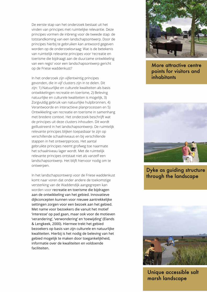
De eerste stap van het onderzoek bestaat uit het vinden van principes met ruimtelijke relevantie. Deze principes vormen de inbreng voor de tweede stap: de totstandkoming van een landschapsontwerp. Door de principes hierbij te gebruiken kan antwoord gegeven worden op de onderzoeksvraag: Wat is de betekenis van ruimtelijk relevante principes voor ‘recreatie en toerisme die bijdraagt aan de duurzame ontwikkeling van een regio’ voor een landschapsontwerp gericht op de Friese waddenkust?
In het onderzoek zijn vijfentwintig principes gevonden, die in vijf clusters zijn in te delen. Dit zijn: 1) Natuurlijke en culturele kwaliteiten als basis ontwikkelingen recreatie en toerisme, 2) Beleving natuurlijke en culturele kwaliteiten is mogelijk, 3) Zorgvuldig gebruik van natuurlijke hulpbronnen, 4) Verantwoorde en interactieve planprocessen en 5) Ontwikkeling van recreatie en toerisme in samenhang met bredere context. Het onderzoek beschrijft wat de principes uit deze clusters inhouden. Dit wordt geïllustreerd in het landschapsontwerp. De ruimtelijk relevante principes blijken toepasbaar te zijn op verschillende schaalniveaus en bij verschillende stappen in het ontwerpproces. Het aantal gebruikte principes neemt grofweg toe naarmate het schaalniveau lager wordt. Met de ruimtelijk relevante principes ontstaat niet als vanzelf een landschapsontwerp. Het blijft hiervoor nodig om te ontwerpen.
In het landschapsontwerp voor de Friese waddenkust komt naar voren dat onder andere de toekomstige versterking van de Waddendijk aangegrepen kan worden voor recreatie en toerisme die bijdragen aan de ontwikkeling van het gebied. Innovatieve dijkconcepten kunnen voor nieuwe aantrekkelijke settingen zorgen voor een bezoek aan het gebied. Met name voor bezoekers die vanuit het motief ‘interesse’ op pad gaan, maar ook voor de motieven ‘verandering’, ‘verwondering’ en ‘toewijding’ (Elands & Lengkeek, 2000). Hiermee trekt het gebied bezoekers op basis van zijn culturele en natuurlijke kwaliteiten. Hierbij is het nodig de beleving van het gebied mogelijk te maken door toegankelijkheid, informatie over de kwaliteiten en voldoende faciliteiten.
New recreational activities and facilities
Sailing connection Wadden Sea and Friesland
Dyke as guiding structure
Existing recreational activities and facilities
Area Zurich-Harlingen
Area Oosterbierum and surroundings
10 20 km
More easy connections between land, dyke and sea
Vision Wadden dyke land
More attractive centre points for visitors and inhabitants
1 2 km
Village/city
Dyke
Road
Water
Grassland
Arable land
Saline agriculture
Legend
Existing bicycle route
New bicycle route
Dyke water strorage zone
Mudflat walking and sailing
Existing facility/activity
New facility/activity
Recreational route on dyke
Nature
Sailing routes
Based upon the analysis a landscape design is created. It is called ‘Wadden dyke land’. In this landscape design the dyke is taken as overarching structure to guide the development of recreation and tourism. This dyke will be strengthened in the near future. By doing this in an innovative way instead of the traditional way of dyke heightening, a new dike zone could be developed. The dyke zone can be the starting point of a visit instead of the end of a visit to the area that guides visitors in the landscape. Coastal defence, and recreation and tourism become combined.
Recreational activities can be expanded around the dyke, for example by new routes on the dyke and in the new salt marshes, with new centre points, birds, saline agriculture and art projects. Cities and villages can support visitors
to the dyke zone by providing a sufficient facility network for nourishment and accommodation. In this way the area will attract visitors based upon its natural and cultural qualities. For Zurich-Harlingen the concept of the overtopping dyke is
chosen. This allows the dynamics of the sea to be present on the land side of the dyke as well. This will create more possibilities to expierence this natural quality of the area and to attract visitors by this.
Dyke as guiding structure through the landscape
Area of Zurich-Harlingen
New entrance of Zurich Crossing of N31 Polder Zuricheroord
1 32
1
2
3
321
Current CurrentCurrent
Unique accessible salt marsh landscape
1. Natuurlijke en culturele kwaliteiten als basis voor ontwikkelingen recreatie en toerisme
2. Beleving natuurlijke en culturele kwaliteiten is mogelijk
3. Zorgvuldig gebruik van natuurlijke hulpbronnen
4. Verantwoorde en interactieve planprocessen
5. Ontwikkeling van recreatie en toerisme in samenhang met bredere context
8
5
5
2
3
Cluster Aantal principes
1. Natural and cultural qualities serve as basis for
recreation and tourism
2. Experience of natural and cultural qualities is possible
3. Careful use of natural sources
4. Responsible and interactive planning
processes
5. Development of recreation and tourism are consistent
with the wider context
Vision
Wad
den
dyke
land
Total
num
ber o
f prin
ciples
Area
Zur
ich-H
arlin
gen
Area
Oos
terbie
rum
and
surro
undin
gs
Zuric
h-Har
linge
n|Cro
ssing
N31
Zuric
h-Har
linge
n|Po
lder Z
urich
eroo
rd
Zuric
h-Har
linge
n|En
tranc
e of Z
urich
Oos
terbie
rum
and
surro
undin
gs|S
alt m
arsh
Total
num
ber o
f diffe
rent
princ
iples
in de
signs
Plan Fryslân aan zee
(Atelier Fryslân, 2012)
Totaal Waddendijkland
totaal
Indication high tide line
Zone nature
Zone recreation
Camping with tent allowed1 2 km
Sustainable recreation and tourism can be viewed from different perspectives. In this study, sustainable recreation and tourism is looked at as forms of recreation and tourism that contribute to the sustainable development of a geographical region (Telfer & Sharpley, 2008). Sustainability is a broad concept; to make it more concrete, oftentimes certain principles are applied. (Hunter,1997; Tanguay & Rajaonson, 2013). Landscape architecture has not yet formulated an answer to the questions what constitutes sustainable recreation and tourism, but some of the principles used in this quest have spatial relevance (GSTC, 2013; EUROPARC Federation, 2010). As a result of this, they could be applied in the design of a landscape. Examples for this use are as of yet non-existent.
The purpose of this study was to provide some insight in the possible ways a landscape can be designed for recreation and tourism, so that recreation and tourism contributes to the sustainable development of a region, by using these spatially relevant principles. The case of the Frisian wadden coast is used to illustrate this.
The spatially relevant principles appear to be applied at different scales and steps in the landscape design. The number of principles used roughly increases at designs with lower scale levels. The spatially relevant principles don’t cause a landscape plan to evolve automatically. It is necessary to enter the activity of designing and to set the design assignment and to use appropriate design principles.
Spatially relevant principles for sustainable recreation and tourism
Supporting
Profiting
Recreation and tourism
Andere ontwikkelingen
Relation recreation & tourism and other developments when it con-tributes to the sustainable development of a region.
Experiencing the starry sky in the salt marsh
1. N
atuu
rlijk
e en
cul
ture
le k
wal
iteite
n al
s ba
sis
voor
ont
wik
kelin
gen
recr
eatie
en
toer
ism
e
2. B
elev
ing
natu
urlij
ke e
n cu
lture
le k
wal
iteite
n is
mog
elijk
3. Z
orgv
uldi
g ge
brui
k va
n na
tuur
lijke
hu
lpbr
onne
n
4. V
eran
twoo
rde
en in
tera
ctie
ve p
lanp
roce
ssen
5. O
ntw
ikke
ling
van
recr
eatie
en
toer
ism
e in
sa
men
hang
met
bre
dere
con
text
8
5 5
2
3
Clu
ster
Aan
tal p
rinci
pes
1. N
atuu
rlijk
e en
cul
ture
le
kwal
iteite
n al
s ba
sis
voor
on
twik
kelin
gen
recr
eatie
en
toer
ism
e
2. B
elev
ing
natu
urlij
ke e
n cu
lture
le k
wal
iteite
n is
mog
elijk
3. Z
orgv
uldi
g ge
brui
k va
n na
tuur
lijke
hu
lpbr
onne
n
4. V
eran
twoo
rde
en
inte
ract
ieve
pla
npro
cess
en
5. O
ntw
ikke
ling
van
recr
eatie
en
toer
ism
e in
sam
enha
ng
met
bre
dere
con
text
Visie
Wad
dend
ijklan
d
Totaa
l aan
tal p
rincip
es
Deelge
bied
Zuric
h-Har
linge
n
Deelge
bied
Oos
terbie
rum
en o
mge
ving
Zuric
h-Har
linge
n|O
verst
eek N
31
Zuric
h-Har
linge
n|Po
lder Z
urich
eroo
rd
Zuric
h-Har
linge
n|En
tree Z
urich
Oos
terbie
rum
en o
mge
ving|
Kweld
er
Totaa
l aan
tal ve
rschil
lende
prin
cipes
in on
twer
pen
Plan
Frysl
ân a
an ze
e
(Atel
ier Fr
yslân
, 201
2)
Totaa
l Wad
dend
ijklan
d
totaal
Liveability local community
Climate change
Coherence spatial developmentsDevelopment strategy for recration and tourismInvolvement of stakeholders
Diminishing pollution, waste by recreationCareful watermanagement
Effective usage of natural sourcesEco-friendly transport
Placement of touristic developmentsDisabled visitors
Information/educational facilitiesParticipation of visitors
Experience of visitors
Discovery of destination
Style of touristic developmentsLocal history
Local entrepeneurs
Special places accessible
Protection of natural and cultural qualitiesIntangible qualities
Protection of vulnerable areasAttractions with natural or cultural value
Oosterbierum and surroundings
New salt marsh Oosterbierum
New salt marsh Oosterbierum
New salt marsh Oosterbierum
1 2 3
5
4
4
5
5
Principles used in total landscape design. Number of principles used increases roughly at lower scale levels.
Current
Current
New recreational activities and facilities
Sailing connection Wadden Sea and Friesland
Dyke as guiding structure
Existing recreational activities and facilities
Area Zurich-Harlingen
Area Oosterbierum and surroundings
10 20 km
More easy connections between land, dyke and sea
Vision Wadden dyke land
More attractive centre points for visitors and inhabitants
1 2 km
Village/city
Dyke
Road
Water
Grassland
Arable land
Saline agriculture
Legend
Existing bicycle route
New bicycle route
Dyke water strorage zone
Mudflat walking and sailing
Existing facility/activity
New facility/activity
Recreational route on dyke
Nature
Sailing routes
Based upon the analysis a landscape design is created. It is called ‘Wadden dyke land’. In this landscape design the dyke is taken as overarching structure to guide the development of recreation and tourism. This dyke will be strengthened in the near future. By doing this in an innovative way instead of the traditional way of dyke heightening, a new dike zone could be developed. The dyke zone can be the starting point of a visit instead of the end of a visit to the area that guides visitors in the landscape. Coastal defence, and recreation and tourism become combined.
Recreational activities can be expanded around the dyke, for example by new routes on the dyke and in the new salt marshes, with new centre points, birds, saline agriculture and art projects. Cities and villages can support visitors
to the dyke zone by providing a sufficient facility network for nourishment and accommodation. In this way the area will attract visitors based upon its natural and cultural qualities. For Zurich-Harlingen the concept of the overtopping dyke is
chosen. This allows the dynamics of the sea to be present on the land side of the dyke as well. This will create more possibilities to expierence this natural quality of the area and to attract visitors by this.
Dyke as guiding structure through the landscape
Area of Zurich-Harlingen
New entrance of Zurich Crossing of N31 Polder Zuricheroord
1 32
1
2
3
321
Current CurrentCurrent
Unique accessible salt marsh landscape
1. Natuurlijke en culturele kwaliteiten als basis voor ontwikkelingen recreatie en toerisme
2. Beleving natuurlijke en culturele kwaliteiten is mogelijk
3. Zorgvuldig gebruik van natuurlijke hulpbronnen
4. Verantwoorde en interactieve planprocessen
5. Ontwikkeling van recreatie en toerisme in samenhang met bredere context
8
5
5
2
3
Cluster Aantal principes
1. Natural and cultural qualities serve as basis for
recreation and tourism
2. Experience of natural and cultural qualities is possible
3. Careful use of natural sources
4. Responsible and interactive planning
processes
5. Development of recreation and tourism are consistent
with the wider context
Vision
Wad
den
dyke
land
Total
num
ber o
f prin
ciples
Area
Zur
ich-H
arlin
gen
Area
Oos
terbie
rum
and
surro
undin
gs
Zuric
h-Har
linge
n|Cro
ssing
N31
Zuric
h-Har
linge
n|Po
lder Z
urich
eroo
rd
Zuric
h-Har
linge
n|En
tranc
e of Z
urich
Oos
terbie
rum
and
surro
undin
gs|S
alt m
arsh
Total
num
ber o
f diffe
rent
princ
iples
in de
signs
Plan Fryslân aan zee
(Atelier Fryslân, 2012)
Totaal Waddendijkland
totaal
Indication high tide line
Zone nature
Zone recreation
Camping with tent allowed1 2 km
Sustainable recreation and tourism can be viewed from different perspectives. In this study, sustainable recreation and tourism is looked at as forms of recreation and tourism that contribute to the sustainable development of a geographical region (Telfer & Sharpley, 2008). Sustainability is a broad concept; to make it more concrete, oftentimes certain principles are applied. (Hunter,1997; Tanguay & Rajaonson, 2013). Landscape architecture has not yet formulated an answer to the questions what constitutes sustainable recreation and tourism, but some of the principles used in this quest have spatial relevance (GSTC, 2013; EUROPARC Federation, 2010). As a result of this, they could be applied in the design of a landscape. Examples for this use are as of yet non-existent.
The purpose of this study was to provide some insight in the possible ways a landscape can be designed for recreation and tourism, so that recreation and tourism contributes to the sustainable development of a region, by using these spatially relevant principles. The case of the Frisian wadden coast is used to illustrate this.
The spatially relevant principles appear to be applied at different scales and steps in the landscape design. The number of principles used roughly increases at designs with lower scale levels. The spatially relevant principles don’t cause a landscape plan to evolve automatically. It is necessary to enter the activity of designing and to set the design assignment and to use appropriate design principles.
Spatially relevant principles for sustainable recreation and tourism
Supporting
Profiting
Recreation and tourism
Andere ontwikkelingen
Relation recreation & tourism and other developments when it con-tributes to the sustainable development of a region.
Experiencing the starry sky in the salt marsh
1. N
atuu
rlijk
e en
cul
ture
le k
wal
iteite
n al
s ba
sis
voor
ont
wik
kelin
gen
recr
eatie
en
toer
ism
e
2. B
elev
ing
natu
urlij
ke e
n cu
lture
le k
wal
iteite
n is
mog
elijk
3. Z
orgv
uldi
g ge
brui
k va
n na
tuur
lijke
hu
lpbr
onne
n
4. V
eran
twoo
rde
en in
tera
ctie
ve p
lanp
roce
ssen
5. O
ntw
ikke
ling
van
recr
eatie
en
toer
ism
e in
sa
men
hang
met
bre
dere
con
text
8
5 5
2
3
Clu
ster
Aan
tal p
rinci
pes
1. N
atuu
rlijk
e en
cul
ture
le
kwal
iteite
n al
s ba
sis
voor
on
twik
kelin
gen
recr
eatie
en
toer
ism
e
2. B
elev
ing
natu
urlij
ke e
n cu
lture
le k
wal
iteite
n is
mog
elijk
3. Z
orgv
uldi
g ge
brui
k va
n na
tuur
lijke
hu
lpbr
onne
n
4. V
eran
twoo
rde
en
inte
ract
ieve
pla
npro
cess
en
5. O
ntw
ikke
ling
van
recr
eatie
en
toer
ism
e in
sam
enha
ng
met
bre
dere
con
text
Visie
Wad
dend
ijklan
d
Totaa
l aan
tal p
rincip
es
Deelge
bied
Zuric
h-Har
linge
n
Deelge
bied
Oos
terbie
rum
en o
mge
ving
Zuric
h-Har
linge
n|O
verst
eek N
31
Zuric
h-Har
linge
n|Po
lder Z
urich
eroo
rd
Zuric
h-Har
linge
n|En
tree Z
urich
Oos
terbie
rum
en o
mge
ving|
Kweld
er
Totaa
l aan
tal ve
rschil
lende
prin
cipes
in on
twer
pen
Plan
Frysl
ân a
an ze
e
(Atel
ier Fr
yslân
, 201
2)
Totaa
l Wad
dend
ijklan
d
totaal
Liveability local community
Climate change
Coherence spatial developmentsDevelopment strategy for recration and tourismInvolvement of stakeholders
Diminishing pollution, waste by recreationCareful watermanagement
Effective usage of natural sourcesEco-friendly transport
Placement of touristic developmentsDisabled visitors
Information/educational facilitiesParticipation of visitors
Experience of visitors
Discovery of destination
Style of touristic developmentsLocal history
Local entrepeneurs
Special places accessible
Protection of natural and cultural qualitiesIntangible qualities
Protection of vulnerable areasAttractions with natural or cultural value
Oosterbierum and surroundings
New salt marsh Oosterbierum
New salt marsh Oosterbierum
New salt marsh Oosterbierum
1 2 3
5
4
4
5
5
Principles used in total landscape design. Number of principles used increases roughly at lower scale levels.
Current
Current
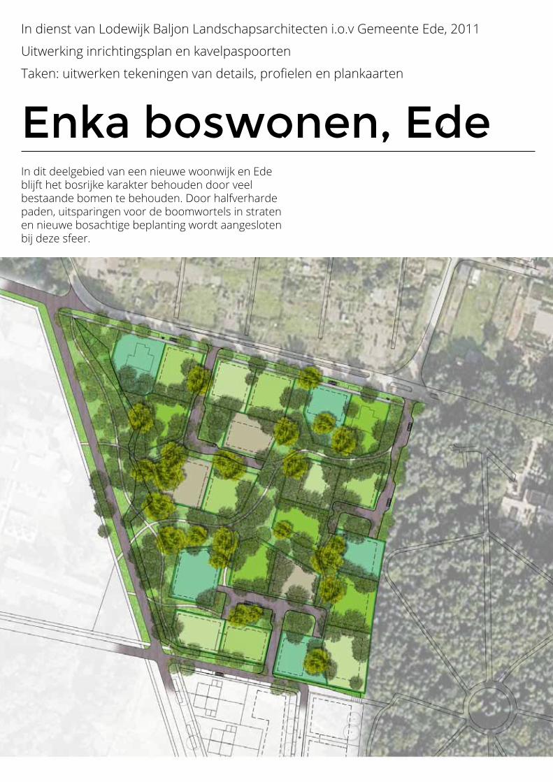
Enka boswonen, Ede
In dienst van Lodewijk Baljon Landschapsarchitecten i.o.v Gemeente Ede, 2011
Uitwerking inrichtingsplan en kavelpaspoorten
Taken: uitwerken tekeningen van details, profielen en plankaarten
In dit deelgebied van een nieuwe woonwijk en Ede blijft het bosrijke karakter behouden door veel bestaande bomen te behouden. Door halfverharde paden, uitsparingen voor de boomwortels in straten en nieuwe bosachtige beplanting wordt aangesloten bij deze sfeer.
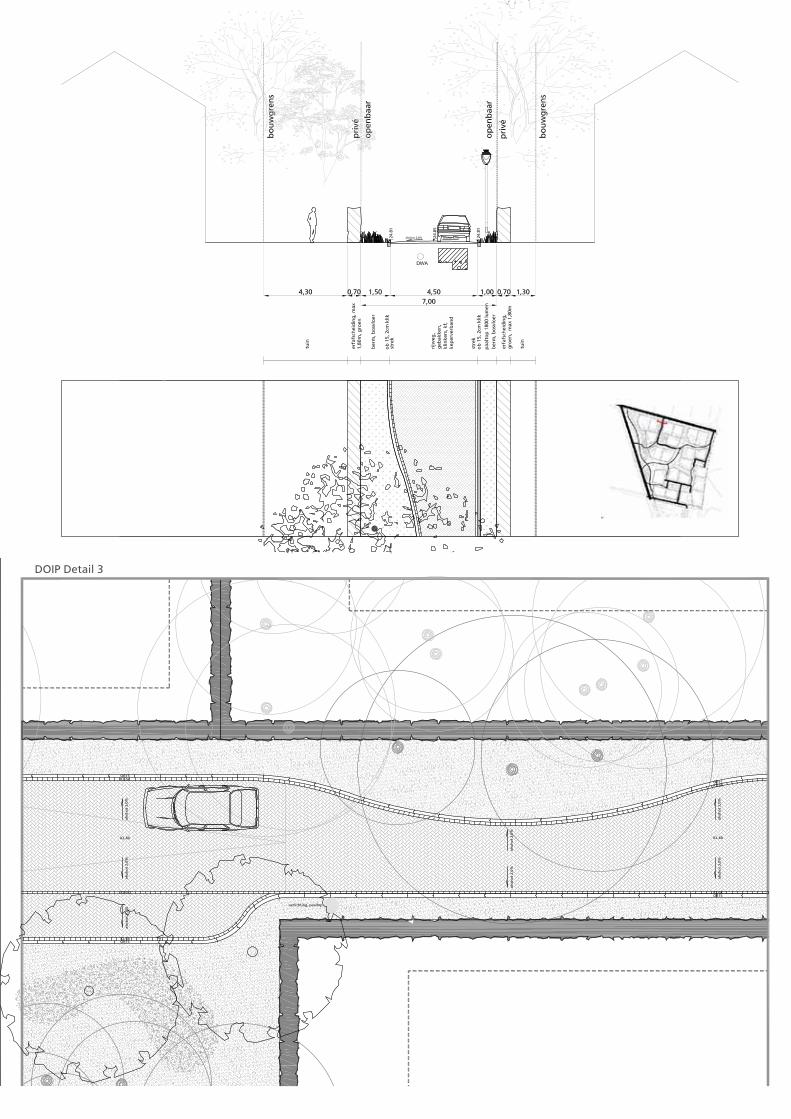
Enka boswonen, Ede
In dienst van Lodewijk Baljon Landschapsarchitecten i.o.v Gemeente Ede, 2011
Uitwerking inrichtingsplan en kavelpaspoorten
Taken: uitwerken tekeningen van details, profielen en plankaarten
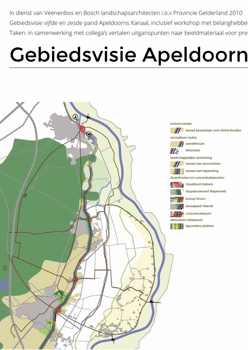
Gebiedsvisie Apeldoorns Kanaal
In dienst van Veenenbos en Bosch landschapsarchitecten i.o.v Provincie Gelderland 2010
Gebiedsvisie vijfde en zesde pand Apeldoorns Kanaal, inclusief workshop met belanghebbenden
Taken: in samenwerking met collega’s vertalen uitganspunten naar beeldmateriaal voor presentaties en rapport
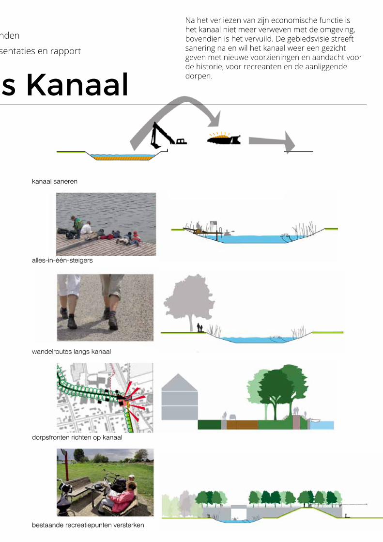
alles-in-één-steigers
wandelroutes langs kanaal
dorpsfronten richten op kanaal
bestaande recreatiepunten versterken
kanaal saneren
Gebiedsvisie Apeldoorns Kanaal
In dienst van Veenenbos en Bosch landschapsarchitecten i.o.v Provincie Gelderland 2010
Gebiedsvisie vijfde en zesde pand Apeldoorns Kanaal, inclusief workshop met belanghebbenden
Taken: in samenwerking met collega’s vertalen uitganspunten naar beeldmateriaal voor presentaties en rapport
Na het verliezen van zijn economische functie is het kanaal niet meer verweven met de omgeving, bovendien is het vervuild. De gebiedsvisie streeft sanering na en wil het kanaal weer een gezicht geven met nieuwe voorzieningen en aandacht voor de historie, voor recreanten en de aanliggende dorpen.
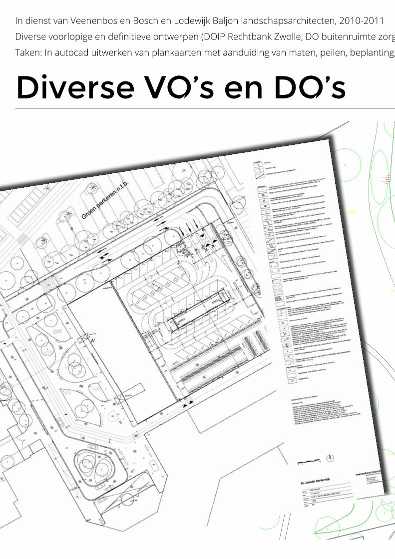
Diverse VO’s en DO’s
In dienst van Veenenbos en Bosch en Lodewijk Baljon landschapsarchitecten, 2010-2011
Diverse voorlopige en definitieve ontwerpen (DOIP Rechtbank Zwolle, DO buitenruimte zorgcentrum, VO/DO Entreegebied ziekenhuis Harderwijk)
Taken: In autocad uitwerken van plankaarten met aanduiding van maten, peilen, beplanting, materialen etc.
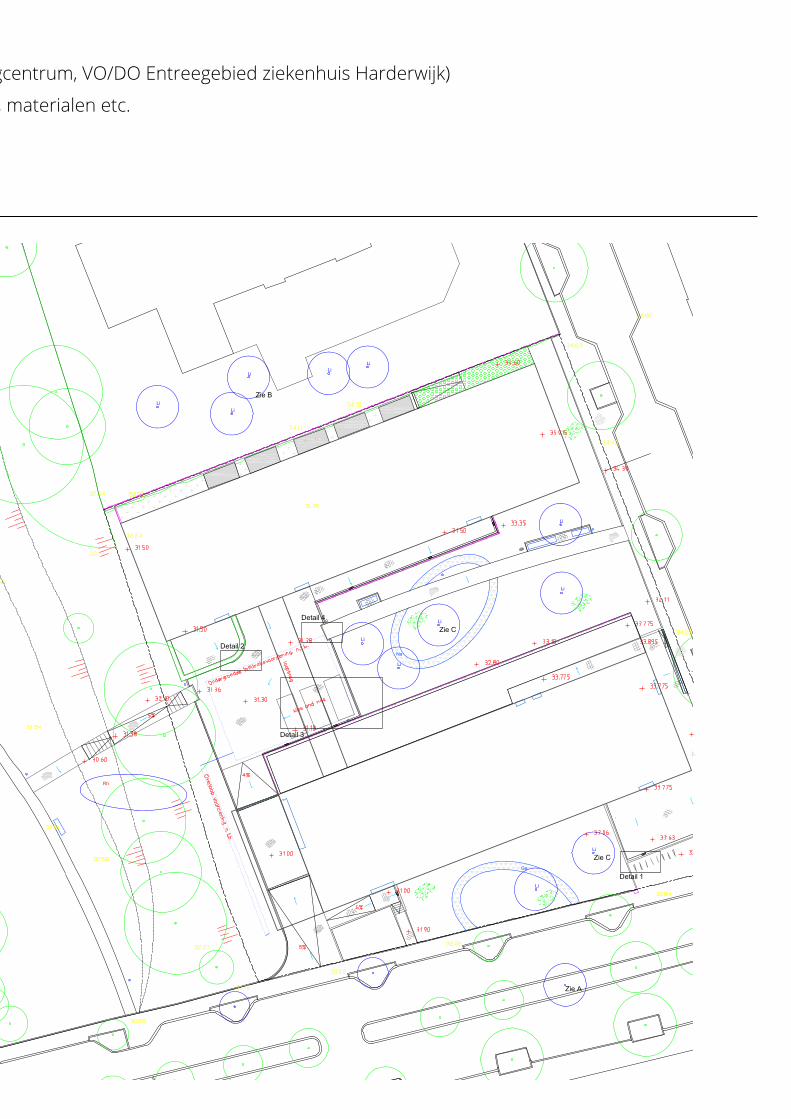
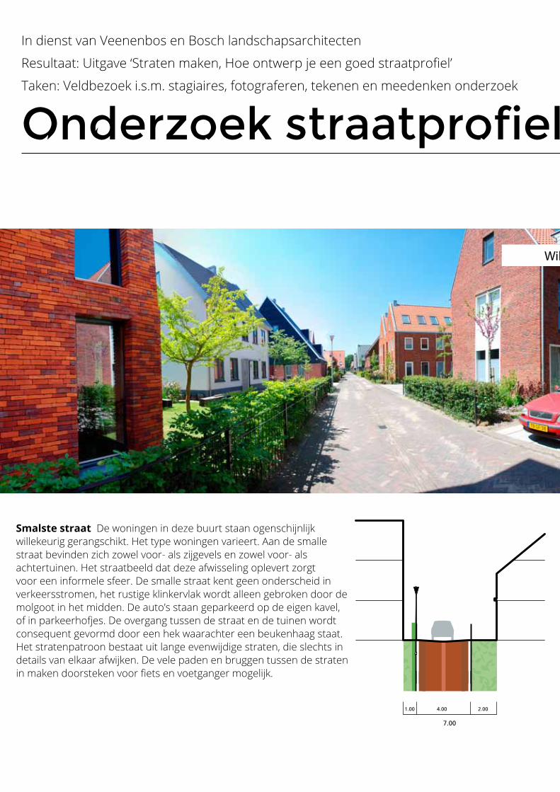
Wilde Gagel Den Haag
1.00 4.00 2.00
7.00
Wilde Gagel Den Haag
1.00 4.00 2.00
7.00
Smalste straat De woningen in deze buurt staan ogenschijnlijk willekeurig gerangschikt. Het type woningen varieert. Aan de smalle straat bevinden zich zowel voor- als zijgevels en zowel voor- als achtertuinen. Het straatbeeld dat deze afwisseling oplevert zorgt voor een informele sfeer. De smalle straat kent geen onderscheid in verkeersstromen, het rustige klinkervlak wordt alleen gebroken door de molgoot in het midden. De auto’s staan geparkeerd op de eigen kavel, of in parkeerhofjes. De overgang tussen de straat en de tuinen wordt consequent gevormd door een hek waarachter een beukenhaag staat. Het stratenpatroon bestaat uit lange evenwijdige straten, die slechts in details van elkaar afwijken. De vele paden en bruggen tussen de straten in maken doorsteken voor fiets en voetganger mogelijk.
Onderzoek straatprofielen
In dienst van Veenenbos en Bosch landschapsarchitecten
Resultaat: Uitgave ‘Straten maken, Hoe ontwerp je een goed straatprofiel’
Taken: Veldbezoek i.s.m. stagiaires, fotograferen, tekenen en meedenken onderzoek
Wilde Gagel Den Haag
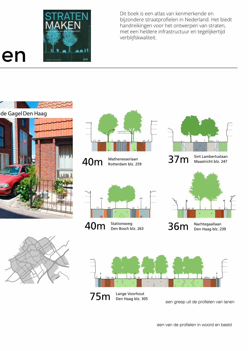
Onderzoek straatprofielen
In dienst van Veenenbos en Bosch landschapsarchitecten
Resultaat: Uitgave ‘Straten maken, Hoe ontwerp je een goed straatprofiel’
Taken: Veldbezoek i.s.m. stagiaires, fotograferen, tekenen en meedenken onderzoek
Wilde Gagel Den Haag
Wilde Gagel Den Haag
een van de profielen in woord en beeld
een greep uit de profielen van lanen
S TA D S L A A N
StationswegDen Bosch blz. 26340m Statenlaan
Den Haag blz. 25141m
Lange VoorhoutDen Haag blz. 30575m
MolenlaanRotterdam blz. 27950mSint Lambertuslaan
Maastricht blz. 24737m
ChurchilllaanAmsterdam blz. 29353m
MathenesserlaanRotterdam blz. 25940m
NachtegaallaanDen Haag blz. 23936m
S TA D S L A A N
StationswegDen Bosch blz. 26340m Statenlaan
Den Haag blz. 25141m
Lange VoorhoutDen Haag blz. 30575m
MolenlaanRotterdam blz. 27950mSint Lambertuslaan
Maastricht blz. 24737m
ChurchilllaanAmsterdam blz. 29353m
MathenesserlaanRotterdam blz. 25940m
NachtegaallaanDen Haag blz. 23936m
Dit boek is een atlas van kenmerkende en bijzondere straatprofielen in Nederland. Het biedt handreikingen voor het ontwerpen van straten, met een heldere infrastructuur en tegelijkertijd verblijfskwaliteit.
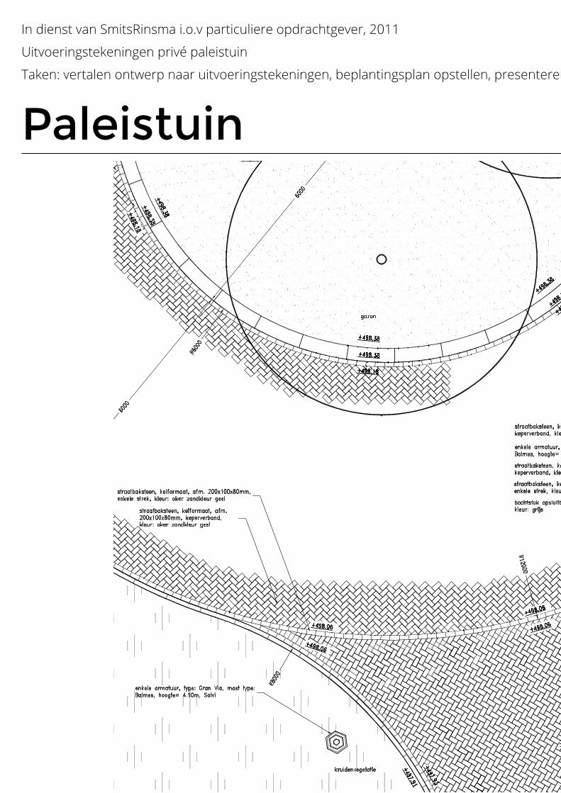
Paleistuin
In dienst van SmitsRinsma i.o.v particuliere opdrachtgever, 2011
Uitvoeringstekeningen privé paleistuin
Taken: vertalen ontwerp naar uitvoeringstekeningen, beplantingsplan opstellen, presenteren aan opdrachtgever
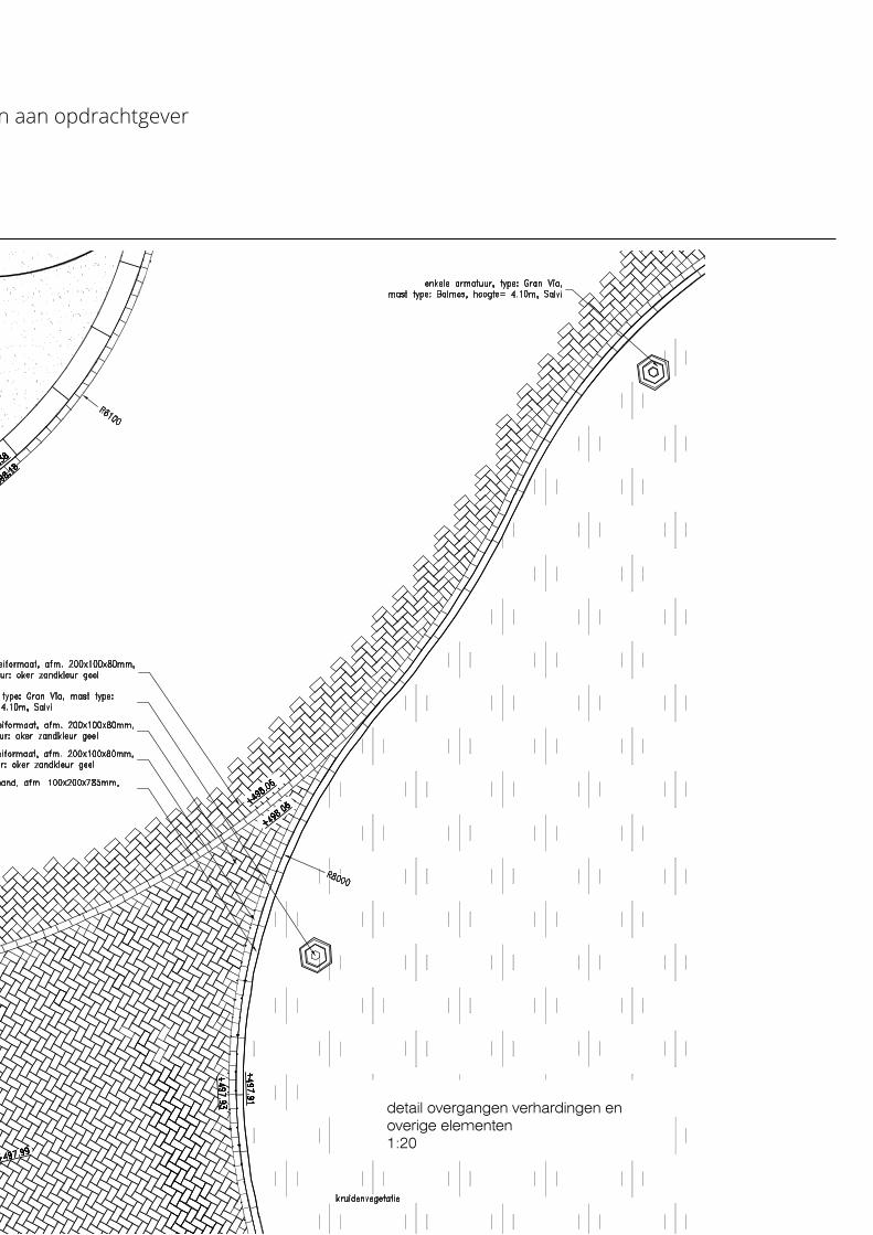
detail overgangen verhardingen en overige elementen1:20
Paleistuin
In dienst van SmitsRinsma i.o.v particuliere opdrachtgever, 2011
Uitvoeringstekeningen privé paleistuin
Taken: vertalen ontwerp naar uitvoeringstekeningen, beplantingsplan opstellen, presenteren aan opdrachtgever
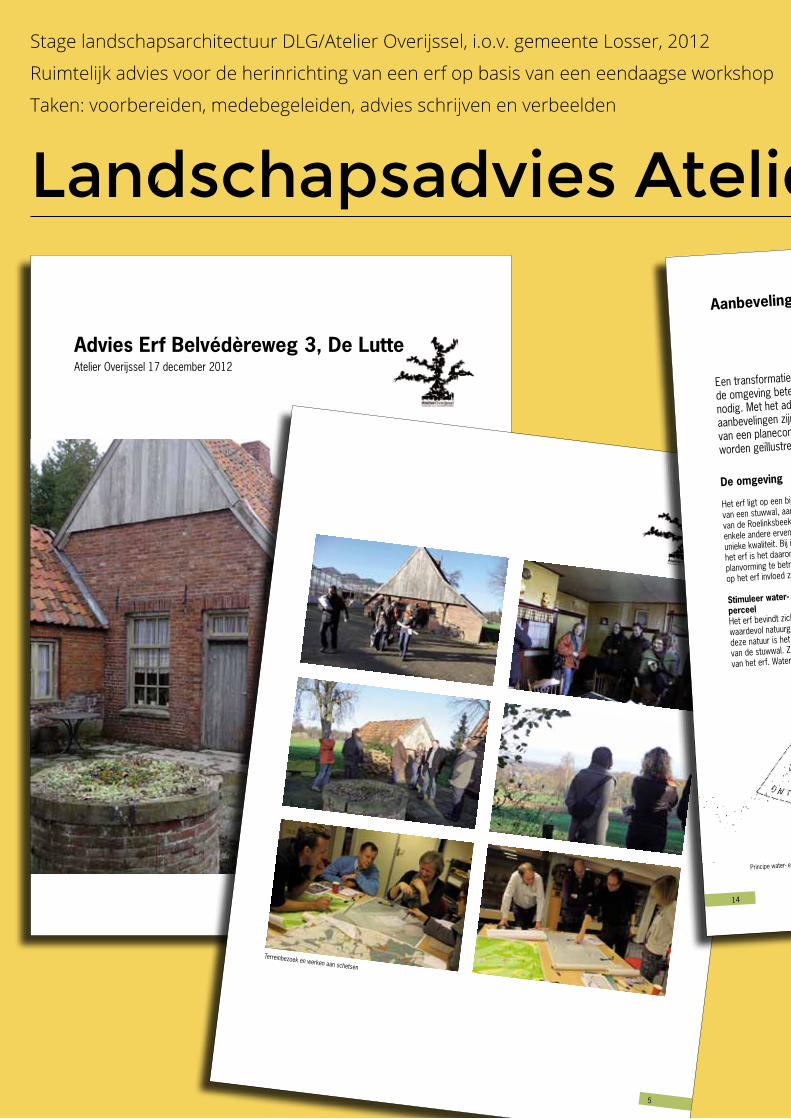
Advies Erf Belvédèreweg 3, De LutteAtelier Overijssel 17 december 2012
�
Terreinbezoek en werken aan schetsen
Landschapsadvies Atelier Overijssel
Stage landschapsarchitectuur DLG/Atelier Overijssel, i.o.v. gemeente Losser, 2012
Ruimtelijk advies voor de herinrichting van een erf op basis van een eendaagse workshop
Taken: voorbereiden, medebegeleiden, advies schrijven en verbeelden
14
De omgeving
Het erf ligt op een bijzondere locatie. Op de flank
van een stuwwal, aan de rand van het brongebied
van de Roelinksbeek en in een gebied met slechts
enkele andere erven. Deze ligging geeft het erf een
unieke kwaliteit. Bij iedere ontwikkelingsrichting voor
het erf is het daarom waardevol om de context bij de
planvorming te betrekken. Ook omdat ontwikkelingen
op het erf invloed zullen hebben op de omgeving.
Stimuleer water- en natuurontwikkeling op het
perceelHet erf bevindt zich aan de rand van een beschermd
waardevol natuurgebied. Een van de kenmerken van
deze natuur is het ontstaan van beekjes aan de rand
van de stuwwal. Zo ook de Roelinksbeek in de buurt
van het erf. Waterretentie op het perceel kan bijdragen
Een transformatie van het erf en kassencomplex kan een ruimtelijke kwaliteitsimpuls voor
de omgeving betekenen. Hiervoor is een zorgvuldige afweging van nieuwe initiatieven
nodig. Met het advies krijgt de Gemeente Losser handvatten om dit te kunnen doen. De
aanbevelingen zijn gebaseerd op de uitkomsten van de scenario’s, grove berekeningen
van een planeconoom en eigen inzicht en kennis van Atelier Overijssel. De aanbevelingen
worden geïllustreerd aan de hand van principe tekeningen.
Aanbevelingen
Principe water- en natuurontwikkeling
aan het herstellen van het watersysteem. Laat de
ontwikkeling van het erf samengaan met water- en
natuurontwikkeling en zorg zo voor herstel van dit
stukje van het watersysteem.
Ga uit van de draagkracht van de omgeving
Het erf is toegankelijk via de Belvédèreweg, die
deels over het erf van Groot Beverborg loopt. Dit
maakt de weg niet geschikt voor een groot aantal
verkeersbewegingen. Mocht de weg een ander tracé
krijgen, dan nog is het gezien de rust van het gebied
wenselijk dat er weinig verkeersbewegingen blijven.
Bekijk de entree van het erf
Bij nieuwe plannen is het wellicht handig om de
bestaande entree van het erf aan te passen, in
samenspraak met de buren van het erf. Nu ligt de
Belvédèreweg een klein stuk over het erf van nummer
Weinig draagkracht Belévèreweg
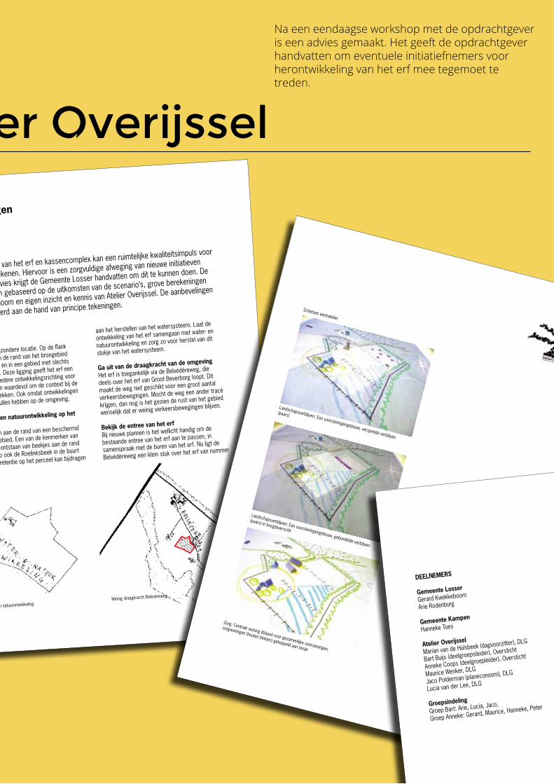
21
Landschapsverblijven: Een voorzieningengebouw, verspreide verblijven
(paars)
Landschapsverblijven: Een voorzieningengebouw, gebundelde verblijven
(paars) in hoogteverschil
Zorg: Centrale woning (blauw) voor gezamenlijke voorzieningen,
zorgwoningen (houten blokjes) gekoppeld aan bosje
Schetsen werkatelier
23
DEELNEMERS
Gemeente Losser
Gerard Kwekkeboom
Arie Rodenburg
Gemeente Kampen
Hanneke Toes
Atelier Overijssel
Marian van de Hulsbeek (dagvoorzitter), DLG
Bart Buijs (deelgroepsleider), Oversticht
Anneke Coops (deelgroepleider), Oversticht
Maurice Wenker, DLG
Jaco Polderman (planeconoom), DLG
Lucia van der Lee, DLG
Groepsindeling
Groep Bart: Arie, Lucia, Jaco,
Groep Anneke: Gerard, Maurice, Hanneke, Peter
Na een eendaagse workshop met de opdrachtgever is een advies gemaakt. Het geeft de opdrachtgever handvatten om eventuele initiatiefnemers voor herontwikkeling van het erf mee tegemoet te treden.
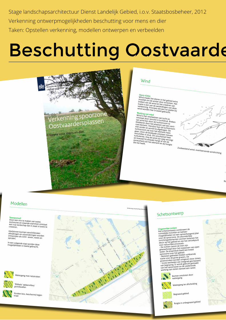
Luwte voor mens en dier.
Verkenning spoorzone
Oostvaardersplassen
Wind
Verkenning | beschutting OostvaardersplassenOpen vlakteWind maakt het dieren in het gebied extra moeilijk om de winter door te komen. Het breken van de wind en het creeëren van luwte is een van de aanleidingen van deze verkenning. Principes die een rol spelen bij wind worden hier in beeld gebracht. Werking van wind Wind is het verplaatsen van lucht en
ontstaat door verschil in luchtdruk. Breken van wind kan door de luchtstroom te blokkeren door het plaatsen van een verti-caal element. Hierdoor kan de luchtstroom niet verder en wordt hij afgebogen. De luchtstroom zal over het element heen gaan. Door de blokkade ontstaan nieuwe verschillen in druk. Dit verschijnsel heet turbulentie. Hoe de wind zijn weg vervolgt en hoeveel hij afzwakt hangt af van de poreusheid van het element en de hoogte die het heeft.
Zuidwestend wind, overheersende windrichting
Noordoosten wind, koude wind in winter
Verkenning | beschutting Oostvaardersplassen
Modellen
VoorportaalDoor een mix te maken van water, exclosures en staande stammen ontstaat een ruw landschap dat in staat is luwte te creeeren.
Hierbinnen kunnen verschillenden afwijkingen en uitzonderingen worden ontworpen als zicht- assen, oases en spiralen.
In een volgende stap worden deze mogelijkheden in beeld gebracht.
‘Ribbels’ takkenrillen/grondwallen
Stroken bos, beschermd tegen vraat
Watergang met rietstroken
Beschutting Oostvaardersplassen
Stage landschapsarchitectuur Dienst Landelijk Gebied, i.o.v. Staatsbosbeheer, 2012
Verkenning ontwerpmogelijkheden beschutting voor mens en dier
Taken: Opstellen verkenning, modellen ontwerpen en verbeelden
Verkenning | beschutting Oostvaardersplassen
Uitgewerkte variant
Het schetsontwerp combineert de
ruimtelijke inzichten en beheer-
mogelijkheden tot een samenhangend plan
voor de spoorzone. De afzonderlijke
inrichtingselementen vormen tezamen het
decor op het gebied en zijn het vertrekpunt
voor natuurlijke processen.
- De zichten vanuit de trein zijn
gewaarborgd door het toepassen van open
water. De praambult biedt een breed
panorama over het gebied.
- Besloten gebieden bieden voldoende
luwte voor de grote grazers. De
groenstroken worden omgeven door sloten.
- Grote eenheden zijn integraal gevrijwaard
van begrazing. Er wordt gebruik gemaakt
van het spoorraster en de veekerende
werking van sloten danwel een raster.
Schetsontwerp
Begraasd gebied
Ruigte in onbegraasd gebied
Watergang ter afscheiding
Bomen omsloten door
watergang
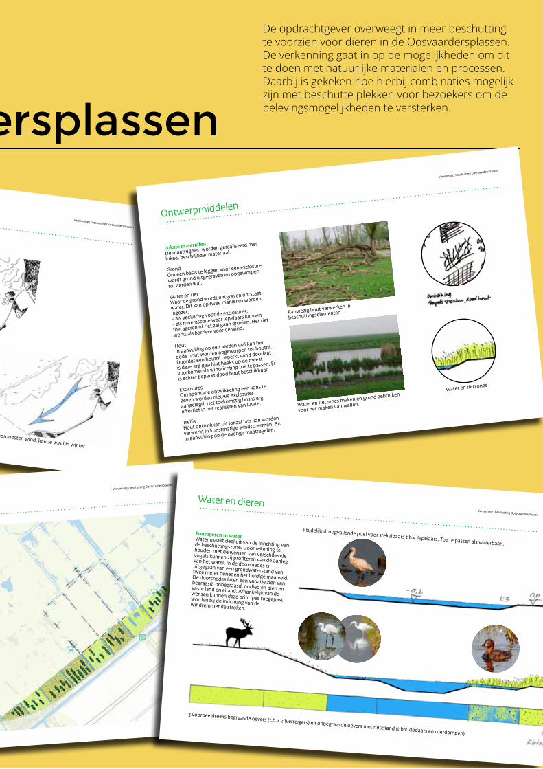
Wind
Verkenning | beschutting OostvaardersplassenOpen vlakteWind maakt het dieren in het gebied extra moeilijk om de winter door te komen. Het breken van de wind en het creeëren van luwte is een van de aanleidingen van deze verkenning. Principes die een rol spelen bij wind worden hier in beeld gebracht. Werking van wind Wind is het verplaatsen van lucht en
ontstaat door verschil in luchtdruk. Breken van wind kan door de luchtstroom te blokkeren door het plaatsen van een verti-caal element. Hierdoor kan de luchtstroom niet verder en wordt hij afgebogen. De luchtstroom zal over het element heen gaan. Door de blokkade ontstaan nieuwe verschillen in druk. Dit verschijnsel heet turbulentie. Hoe de wind zijn weg vervolgt en hoeveel hij afzwakt hangt af van de poreusheid van het element en de hoogte die het heeft.
Zuidwestend wind, overheersende windrichting
Noordoosten wind, koude wind in winter
Beschutting Oostvaardersplassen
Stage landschapsarchitectuur Dienst Landelijk Gebied, i.o.v. Staatsbosbeheer, 2012
Verkenning ontwerpmogelijkheden beschutting voor mens en dier
Taken: Opstellen verkenning, modellen ontwerpen en verbeelden
Lokale materialen
De maatregelen worden gerealiseerd met
lokaal beschikbaar materiaal.
GrondOm een basis te leggen voor een exclosure
wordt grond uitgegraven en opgeworpen
tot aarden wal.
Water en riet
Waar de grond wordt ontgraven ontstaat
water. Dit kan op twee manieren worden
ingezet;- als veekering voor de exclosures.
- als moeraszone waar lepelaars kunnen
foerageren of riet zal gaan groeien. Het riet
werkt als barriere voor de wind.
HoutIn aanvulling op een aarden wal kan het
dode hout worden opgeworpen tot houtril.
Doordat een houtril beperkt wind doorlaat
is deze erg geschikt haaks op de meest
voorkomende windrichting toe te passen. Er
is echter beperkt dood hout beschikbaar.
ExclosuresOm spontane ontwikkeling een kans te
geven worden nieuwe exclosures
aangelegd. Het toekomstig bos is erg
effectief in het realiseren van luwte.
TrellisHout onttrokken uit lokaal bos kan worden
verwerkt in kunstmatige windschermen. Bv.
in aanvulling op de overige maatregelen.
Ontwerpmiddelen
Verkenning | beschutting Oostvaardersplassen
Aanwezig hout verwerken in
beschuttingselementen
Water en rietzones maken en grond gebruiken
voor het maken van wallen.
Water en rietzones
Verkenning | beschutting Oostvaardersplassen
Uitgewerkte variant
Het schetsontwerp combineert de
ruimtelijke inzichten en beheer-
mogelijkheden tot een samenhangend plan
voor de spoorzone. De afzonderlijke
inrichtingselementen vormen tezamen het
decor op het gebied en zijn het vertrekpunt
voor natuurlijke processen.
- De zichten vanuit de trein zijn
gewaarborgd door het toepassen van open
water. De praambult biedt een breed
panorama over het gebied.
- Besloten gebieden bieden voldoende
luwte voor de grote grazers. De
groenstroken worden omgeven door sloten.
- Grote eenheden zijn integraal gevrijwaard
van begrazing. Er wordt gebruik gemaakt
van het spoorraster en de veekerende
werking van sloten danwel een raster.
Schetsontwerp
Begraasd gebied
Ruigte in onbegraasd gebied
Watergang ter afscheiding
Bomen omsloten door
watergang
Water en dierenVerkenning | beschutting Oostvaardersplassen
Fourageren in waterWater maakt deel uit van de inrichting van de beschuttingszone. Door rekening te houden met de wensen van verschillende vogels kunnen zij profiteren van de aanleg van het water. In de doorsnedes is uitgegaan van een grondwaterstand van twee meter beneden het huidige maaiveld. De doorsnedes laten een variatie zien van begraasd, onbegraasd, ondiep en diep en vaste land en eiland. Afhankelijk van de wensen kunnen deze principes toegepast worden bij de inrichting van de windremmende stroken.
1 tijdelijk droogvallende poel voor stekelbaars t.b.v. lepelaars. Toe te passen als waterbaan.
3 voorbeeldreeks begraasde oevers (t.b.v. zilverreigers) en onbegraasde oevers met rieteiland (t.b.v. dodaars en roerdompen)
De opdrachtgever overweegt in meer beschutting te voorzien voor dieren in de Oosvaardersplassen. De verkenning gaat in op de mogelijkheden om dit te doen met natuurlijke materialen en processen. Daarbij is gekeken hoe hierbij combinaties mogelijk zijn met beschutte plekken voor bezoekers om de belevingsmogelijkheden te versterken.
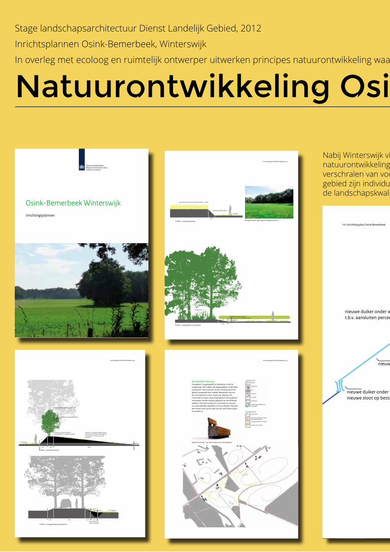
Osink-Bemerbeek WinterswijkInrichtingsplannen
RuimtelijkebelevingHet gebied is toegangkelijk en beleefbaar vanaf de Kuipersweg. Het is deels ook toegangkelijk via het dijkje op de grens met Duitsland. Na de inrichting wordt het gebied opengsteld voor publiek. Wandelaars kunnen door het gebied struinen, paden zijn afwezig. Om recreanten te wijzen op de mogelijkheid om het gebied te betreden worden bankjes geplaatst op verschillende plekken. Ook met het doel om recreanten te voorzien van aantrekkelijke zitplekken in het landschap. Minstens één bankje staat op een plek die ook voor fietsers goed te bereiken is.
Inrichtingsplan Osink-Bemerbeek|13
Bank Pure Grijsen, o.g. Voor locaties zie inrichtingsplan
Inrichtingsplan Osink-Bemerbeek|2�
Deelgebied I Aerdenkruyk - overgang bos en grasland
1:5
1,50
- 0,30 afgraven1:5
bestaand bos
verschillende soorten graslandstrakke bosrand d.m.v. beheer grasland
- 0,30 afgraven - 0,30 afgraven
1:51:1
- 0,30 afgraven
Deelgebied I Aerdenkruyk - esrand graanakker
esrand herstellen, talud 1:1
grasland
1,00
graanakker, verschil met maaiveld grasland + 1,00 m
Deelgebied I Aerdenkruyk - aanhelen houtwal
1,001,30
wal 1,30 boven nieuw maaiveld (+ 1,00 ophogen t.o.v. huidig maaiveld)
nieuwe bomen planten op rand steilste talud70% haagbeuk20% eik10% beuken
bestaande bomen op bestaande houtwal
6,50
Deelgebied I Aerdenkruyk - overgang weg naar grasland
0,60 5,00 0,60
huidig maaiveld
gedempte sloot
bestaand talud 1:3nieuw talud 1:5
1,40
Huidige situatie, glooiing en hoogteverschil esProfiel 1, rand graankampje
Deelgebied I Aerdenkruyk - overgang bos en grasland
1:5
1,50
- 0,30 afgraven1:5
bestaand bos
verschillende soorten graslandstrakke bosrand d.m.v. beheer grasland
- 0,30 afgraven - 0,30 afgraven
1:51:1
- 0,30 afgraven
Deelgebied I Aerdenkruyk - esrand graanakker
esrand herstellen, talud 1:1
grasland
1,00
graanakker, verschil met maaiveld grasland + 1,00 m
Deelgebied I Aerdenkruyk - aanhelen houtwal
1,001,30
wal 1,30 boven nieuw maaiveld (+ 1,00 ophogen t.o.v. huidig maaiveld)
nieuwe bomen planten op rand steilste talud70% haagbeuk20% eik10% beuken
bestaande bomen op bestaande houtwal
6,50
Deelgebied I Aerdenkruyk - overgang weg naar grasland
0,60 5,00 0,60
huidig maaiveld
gedempte sloot
bestaand talud 1:3nieuw talud 1:5
1,40
Streefbeeld profiel 2, strakke grens bos en weide Profiel 2, overgang bos en grasland
Deelgebied I Aerdenkruyk - overgang bos en grasland
1:5
1,50
- 0,30 afgraven1:5
bestaand bos
verschillende soorten graslandstrakke bosrand d.m.v. beheer grasland
- 0,25 afgraven- 0,30 afgraven
1:51:1
- 0,30 afgraven
Deelgebied I Aerdenkruyk - esrand graanakker
esrand herstellen, talud 1:1
grasland
1,00
graanakker, verschil met maaiveld grasland + 1,00 m
Deelgebied I Aerdenkruyk - aanhelen houtwal
1,001,25
wal 1,30 boven nieuw maaiveld (+ 1,00 ophogen t.o.v. huidig maaiveld)
nieuwe bomen planten op rand steilste talud70% haagbeuk20% eik10% beuken
bestaande bomen op bestaande houtwal
13,00
Deelgebied I Aerdenkruyk - overgang weg naar grasland
0,90 5,00 0,90
huidig maaiveld
gedempte sloot,contour indicatief
bestaand talud 1:3nieuw talud 1:5
1,10
onderste 5 cm grond van afgraven delen gebruiken voor aanhelen wal, zodat leem wordt gebruikt en niet grond van de bouwvoor
Steile zijde talud van de resterende houtwal
Huidig, weg hoger dan weide
Profiel 4, overgang weg naar grasland
Profiel 3, aanhelen houtwal
Inrichtingsplan Osink-Bemerbeek|2�
Stage landschapsarchitectuur Dienst Landelijk Gebied, 2012
Inrichtsplannen Osink-Bemerbeek, Winterswijk
In overleg met ecoloog en ruimtelijk ontwerper uitwerken principes natuurontwikkeling waarbij landschapskwaliteiten worden versterkt
Profiel 1
-0,40 -0,40
-0,30 -0,60 -0,40
-0,30
-0,30
-0,30-0,45
-0,20
-0,40
kade, + 0,40 boven maaiveldvan in te richten terrein
bestaande duiker
nieuwe duiker onder weg t.b.v. aansluiten perceel op sloot
nieuwe duiker onder weg t.b.v. aansluitennieuwe sloot op bestaande sloot
te dempen sloot
nieuwe sloot
bestaande grensdijk
nieuwe bomen (berken),verspringende plantafstand als op kaart
Kleine zeggevegetaties
Te verwachten vegetatie
Maatregelen
Kleine zeggevegetaties
Natte heide
Vochtig heischraalgrasland
Voorde, doorwaadbare plekin grensdijk
Veldrusschraalland envochtigheischraalland
Berken- elzenbroekbos
WaterBestaande sloot
Nieuwe sloot ter vervangingvan afwatering gedempte sloten
Plasdras in winterseizoen
Kade t.b.v. droog houden aangrenzende perceel
Landschappelijke elementen
Grensdijk
Nieuwe berken
Bestaande berken en andere soorten bomen
Ruimtelijke beleving
Overig
Aansluitende paden en wegenmet ingangen gebied
Ven, blijvend nat
Bestaande duiker
Nieuwe duiker, t.b.v. aansluiting sloten en afvoer regenwater perceel
Te dempen sloot
Af te graven grond,diepte in meters
Bank (Pure Grijsen o.g.)
Plangrens
0 50 100 200m
Legenda
N
1� | Inrichtingsplan Osink-Bemerbeek
Inrichtingsplan deelgebied Kottense Veen
Natuurontwikkeling Osink-Bemerbeek
Nabij Winterswijk vindt in vier deelgebieden natuurontwikkeling plaats. Het gaat vooral om het verschralen van voormalige landbouwgronden. Voor ieder gebied zijn individuele aandachtspunten gegeven om ook de landschapskwaliteiten te behouden en versterken.
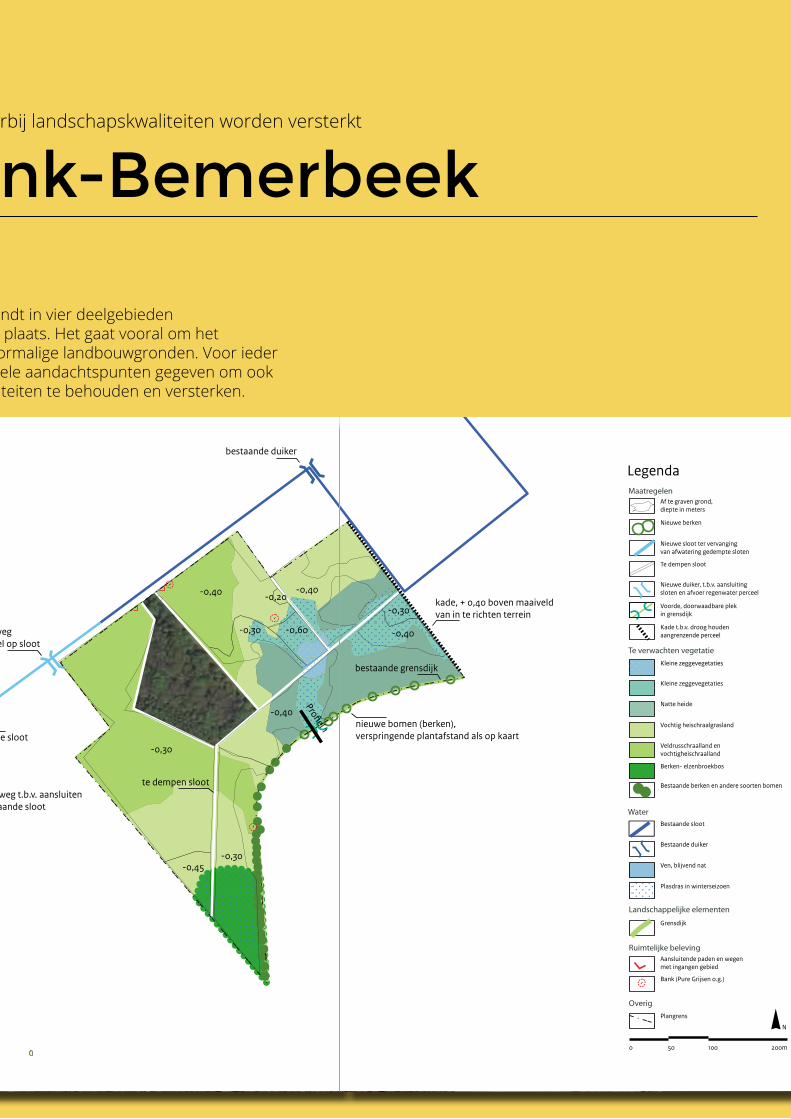
Stage landschapsarchitectuur Dienst Landelijk Gebied, 2012
Inrichtsplannen Osink-Bemerbeek, Winterswijk
In overleg met ecoloog en ruimtelijk ontwerper uitwerken principes natuurontwikkeling waarbij landschapskwaliteiten worden versterkt
Profiel 1
-0,40 -0,40
-0,30 -0,60 -0,40
-0,30
-0,30
-0,30-0,45
-0,20
-0,40
kade, + 0,40 boven maaiveldvan in te richten terrein
bestaande duiker
nieuwe duiker onder weg t.b.v. aansluiten perceel op sloot
nieuwe duiker onder weg t.b.v. aansluitennieuwe sloot op bestaande sloot
te dempen sloot
nieuwe sloot
bestaande grensdijk
nieuwe bomen (berken),verspringende plantafstand als op kaart
Kleine zeggevegetaties
Te verwachten vegetatie
Maatregelen
Kleine zeggevegetaties
Natte heide
Vochtig heischraalgrasland
Voorde, doorwaadbare plekin grensdijk
Veldrusschraalland envochtigheischraalland
Berken- elzenbroekbos
WaterBestaande sloot
Nieuwe sloot ter vervangingvan afwatering gedempte sloten
Plasdras in winterseizoen
Kade t.b.v. droog houden aangrenzende perceel
Landschappelijke elementen
Grensdijk
Nieuwe berken
Bestaande berken en andere soorten bomen
Ruimtelijke beleving
Overig
Aansluitende paden en wegenmet ingangen gebied
Ven, blijvend nat
Bestaande duiker
Nieuwe duiker, t.b.v. aansluiting sloten en afvoer regenwater perceel
Te dempen sloot
Af te graven grond,diepte in meters
Bank (Pure Grijsen o.g.)
Plangrens
0 50 100 200m
Legenda
N
1� | Inrichtingsplan Osink-Bemerbeek
Inrichtingsplan deelgebied Kottense VeenProfiel 1
-0,40 -0,40
-0,30 -0,60 -0,40
-0,30
-0,30
-0,30-0,45
-0,20
-0,40
kade, + 0,40 boven maaiveldvan in te richten terrein
bestaande duiker
nieuwe duiker onder weg t.b.v. aansluiten perceel op sloot
nieuwe duiker onder weg t.b.v. aansluitennieuwe sloot op bestaande sloot
te dempen sloot
nieuwe sloot
bestaande grensdijk
nieuwe bomen (berken),verspringende plantafstand als op kaart
Kleine zeggevegetaties
Te verwachten vegetatie
Maatregelen
Kleine zeggevegetaties
Natte heide
Vochtig heischraalgrasland
Voorde, doorwaadbare plekin grensdijk
Veldrusschraalland envochtigheischraalland
Berken- elzenbroekbos
WaterBestaande sloot
Nieuwe sloot ter vervangingvan afwatering gedempte sloten
Plasdras in winterseizoen
Kade t.b.v. droog houden aangrenzende perceel
Landschappelijke elementen
Grensdijk
Nieuwe berken
Bestaande berken en andere soorten bomen
Ruimtelijke beleving
Overig
Aansluitende paden en wegenmet ingangen gebied
Ven, blijvend nat
Bestaande duiker
Nieuwe duiker, t.b.v. aansluiting sloten en afvoer regenwater perceel
Te dempen sloot
Af te graven grond,diepte in meters
Bank (Pure Grijsen o.g.)
Plangrens
0 50 100 200m
Legenda
N
Natuurontwikkeling Osink-Bemerbeek
Nabij Winterswijk vindt in vier deelgebieden natuurontwikkeling plaats. Het gaat vooral om het verschralen van voormalige landbouwgronden. Voor ieder gebied zijn individuele aandachtspunten gegeven om ook de landschapskwaliteiten te behouden en versterken.
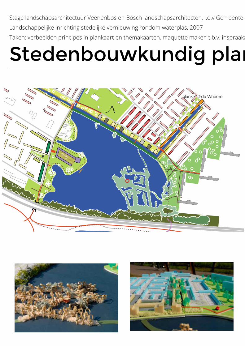
plankaart de Wheme
Stedenbouwkundig plan De Wheme, Arnhem
Stage landschapsarchitectuur Veenenbos en Bosch landschapsarchitecten, i.o.v Gemeente Arnhem
Landschappelijke inrichting stedelijke vernieuwing rondom waterplas, 2007
Taken: verbeelden principes in plankaart en themakaarten, maquette maken t.b.v. inspraakavonden met burgers
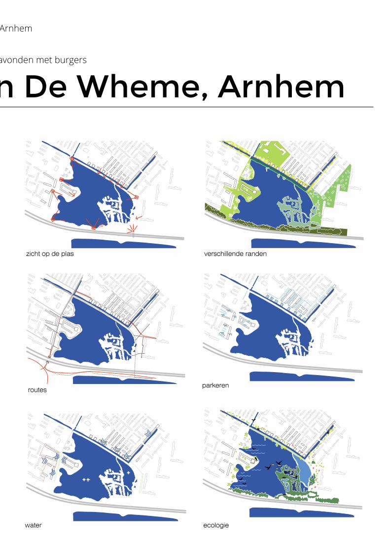
zicht op de plas verschillende randen
routesparkeren
water ecologie
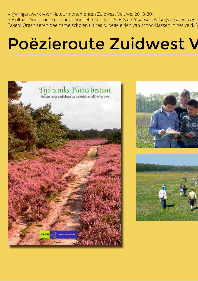
Poëzieroute Zuidwest Veluwe
Vrijwilligerswerk voor Natuurmonumenten Zuidwest Veluwe, 2010-2011 Resultaat: Audioroute en poëziebundel: Tijd is niks. Plaats bestaat. Fietsen langs gedichten op de Zuidwestelijke VeluweTaken: Organiseren deelname scholen uit regio, begeleiden van schoolklassen in het veld. Samenstellen bundel samen met Adinda Crans (projectleider) en Machiel Bosch (beheerder)
Schoolklas bezoekt het gebied, schrijft gedichten en draagt ze voor.