Leica BLK360 Leica ScanStation P30/ ArtecRay FARO FOCUS ...
1
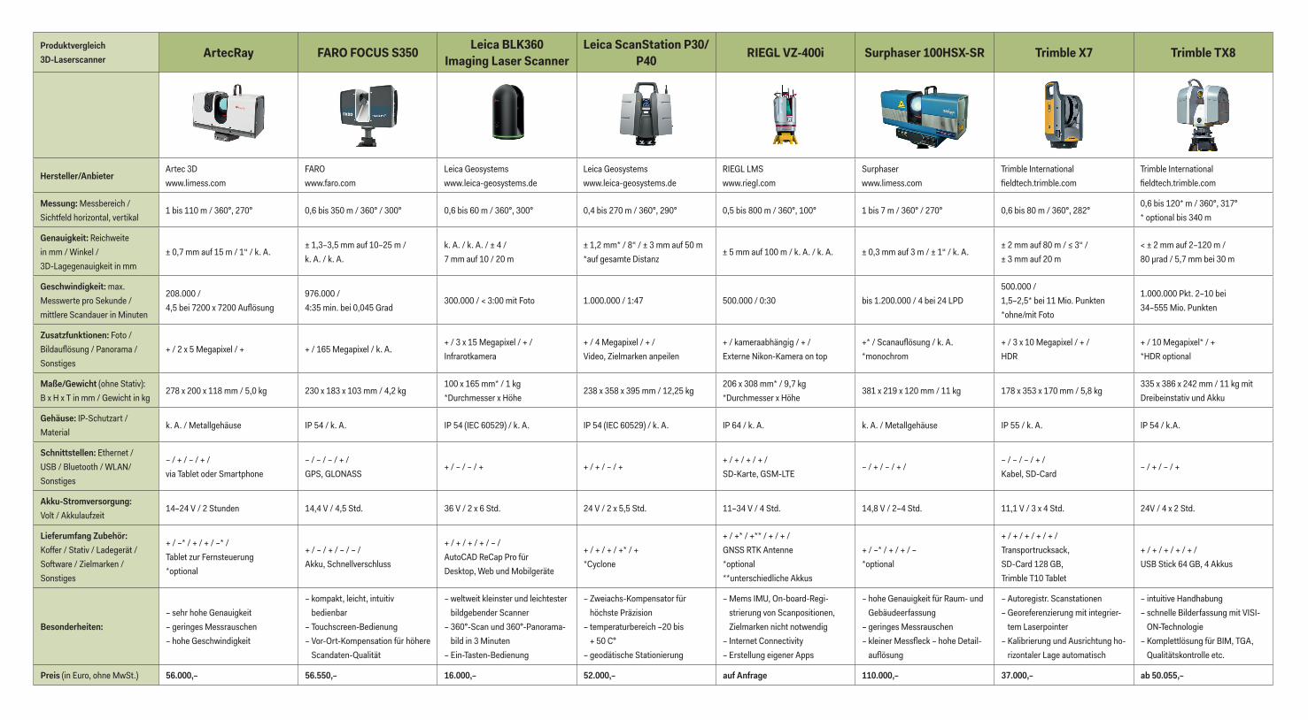
Produktvergleich 3D-Laserscanner ArtecRay FARO FOCUS S350 Leica BLK360 Imaging Laser Scanner Leica ScanStation P30/ P40 RIEGL VZ-400i Surphaser 100HSX-SR Trimble X7 Trimble TX8 Hersteller/Anbieter Artec 3D www.limess.com FARO www.faro.com Leica Geosystems www.leica-geosystems.de Leica Geosystems www.leica-geosystems.de RIEGL LMS www.riegl.com Surphaser www.limess.com Trimble International fieldtech.trimble.com Trimble International fieldtech.trimble.com Messung: Messbereich / Sichtfeld horizontal, vertikal 1 bis 110 m / 360°, 270° 0,6 bis 350 m / 360° / 300° 0,6 bis 60 m / 360°, 300° 0,4 bis 270 m / 360°, 290° 0,5 bis 800 m / 360°, 100° 1 bis 7 m / 360° / 270° 0,6 bis 80 m / 360°, 282° 0,6 bis 120* m / 360°, 317° * optional bis 340 m Genauigkeit: Reichweite in mm / Winkel / 3D-Lagegenauigkeit in mm ± 0,7 mm auf 15 m / 1“ / k. A. ± 1,3–3,5 mm auf 10–25 m / k. A. / k. A. k. A. / k. A. / ± 4 / 7 mm auf 10 / 20 m ± 1,2 mm* / 8“ / ± 3 mm auf 50 m *auf gesamte Distanz ± 5 mm auf 100 m / k. A. / k. A. ± 0,3 mm auf 3 m / ± 1“ / k. A. ± 2 mm auf 80 m / ≤ 3“ / ± 3 mm auf 20 m < ± 2 mm auf 2–120 m / 80 μrad / 5,7 mm bei 30 m Geschwindigkeit: max. Messwerte pro Sekunde / mittlere Scandauer in Minuten 208.000 / 4,5 bei 7200 x 7200 Auflösung 976.000 / 4:35 min. bei 0,045 Grad 300.000 / < 3:00 mit Foto 1.000.000 / 1:47 500.000 / 0:30 bis 1.200.000 / 4 bei 24 LPD 500.000 / 1,5–2,5* bei 11 Mio. Punkten *ohne/mit Foto 1.000.000 Pkt. 2–10 bei 34–555 Mio. Punkten Zusatzfunktionen: Foto / Bildauflösung / Panorama / Sonstiges + / 2 x 5 Megapixel / + + / 165 Megapixel / k. A. + / 3 x 15 Megapixel / + / Infrarotkamera + / 4 Megapixel / + / Video, Zielmarken anpeilen + / kameraabhängig / + / Externe Nikon-Kamera on top +* / Scanauflösung / k. A. *monochrom + / 3 x 10 Megapixel / + / HDR + / 10 Megapixel* / + *HDR optional Maße/Gewicht (ohne Stativ): B x H x T in mm / Gewicht in kg 278 x 200 x 118 mm / 5,0 kg 230 x 183 x 103 mm / 4,2 kg 100 x 165 mm* / 1 kg *Durchmesser x Höhe 238 x 358 x 395 mm / 12,25 kg 206 x 308 mm* / 9,7 kg *Durchmesser x Höhe 381 x 219 x 120 mm / 11 kg 178 x 353 x 170 mm / 5,8 kg 335 x 386 x 242 mm / 11 kg mit Dreibeinstativ und Akku Gehäuse: IP-Schutzart / Material k. A. / Metallgehäuse IP 54 / k. A. IP 54 (IEC 60529) / k. A. IP 54 (IEC 60529) / k. A. IP 64 / k. A. k. A. / Metallgehäuse IP 55 / k. A. IP 54 / k.A. Schnittstellen: Ethernet / USB / Bluetooth / WLAN/ Sonstiges – / + / – / + / via Tablet oder Smartphone – / – / – / + / GPS, GLONASS + / – / – / + + / + / – / + + / + / + / + / SD-Karte, GSM-LTE – / + / – / + / – / – / – / + / Kabel, SD-Card – / + / – / + Akku-Stromversorgung: Volt / Akkulaufzeit 14–24 V / 2 Stunden 14,4 V / 4,5 Std. 36 V / 2 x 6 Std. 24 V / 2 x 5,5 Std. 11–34 V / 4 Std. 14,8 V / 2–4 Std. 11,1 V / 3 x 4 Std. 24V / 4 x 2 Std. Lieferumfang Zubehör: Koffer / Stativ / Ladegerät / Soſtware / Zielmarken / Sonstiges + / –* / + / + / –* / Tablet zur Fernsteuerung *optional + / – / + / – / – / Akku, Schnellverschluss + / + / + / + / – / AutoCAD ReCap Pro für Desktop, Web und Mobilgeräte + / + / + / +* / + *Cyclone + / +* / +** / + / + / GNSS RTK Antenne *optional **unterschiedliche Akkus + / –* / + / + / – *optional + / + / + / + / + / Transportrucksack, SD-Card 128 GB, Trimble T10 Tablet + / + / + / + / + / USB Stick 64 GB, 4 Akkus Besonderheiten: – sehr hohe Genauigkeit – geringes Messrauschen – hohe Geschwindigkeit – kompakt, leicht, intuitiv bedienbar – Touchscreen-Bedienung – Vor-Ort-Kompensation für höhere Scandaten-Qualität – weltweit kleinster und leichtester bildgebender Scanner – 360°-Scan und 360°-Panorama- bild in 3 Minuten – Ein-Tasten-Bedienung – Zweiachs-Kompensator für höchste Präzision – temperaturbereich –20 bis + 50 C° – geodätische Stationierung – Mems IMU, On-board-Regi- strierung von Scanpositionen, Zielmarken nicht notwendig – Internet Connectivity – Erstellung eigener Apps – hohe Genauigkeit für Raum- und Gebäudeerfassung – geringes Messrauschen – kleiner Messfleck – hohe Detail- auflösung – Autoregistr. Scanstationen – Georeferenzierung mit integrier- tem Laserpointer – Kalibrierung und Ausrichtung ho- rizontaler Lage automatisch – intuitive Handhabung – schnelle Bilderfassung mit VISI- ON-Technologie – Komplettlösung für BIM, TGA, Qualitätskontrolle etc. Preis (in Euro, ohne MwSt.) 56.000,– 56.550,– 16.000,– 52.000,– auf Anfrage 110.000,– 37.000,– ab 50.055,–
Transcript of Leica BLK360 Leica ScanStation P30/ ArtecRay FARO FOCUS ...
Produktvergleich 3D-Laserscanner ArtecRay FARO FOCUS S350 Leica BLK360
Imaging Laser ScannerLeica ScanStation P30/
P40 RIEGL VZ-400i Surphaser 100HSX-SR Trimble X7 Trimble TX8
Hersteller/AnbieterArtec 3Dwww.limess.com
FAROwww.faro.com
Leica Geosystemswww.leica-geosystems.de
Leica Geosystemswww.leica-geosystems.de
RIEGL LMSwww.riegl.com
Surphaserwww.limess.com
Trimble International fi eldtech.trimble.com
Trimble International fi eldtech.trimble.com
Messung: Messbereich / Sichtfeld horizontal, vertikal
1 bis 110 m / 360°, 270° 0,6 bis 350 m / 360° / 300° 0,6 bis 60 m / 360°, 300° 0,4 bis 270 m / 360°, 290° 0,5 bis 800 m / 360°, 100° 1 bis 7 m / 360° / 270° 0,6 bis 80 m / 360°, 282°0,6 bis 120* m / 360°, 317° * optional bis 340 m
Genauigkeit: Reichweite in mm / Winkel / 3D-Lagegenauigkeit in mm
± 0,7 mm auf 15 m / 1“ / k. A.± 1,3–3,5 mm auf 10–25 m / k. A. / k. A.
k. A. / k. A. / ± 4 / 7 mm auf 10 / 20 m
± 1,2 mm* / 8“ / ± 3 mm auf 50 m *auf gesamte Distanz
± 5 mm auf 100 m / k. A. / k. A. ± 0,3 mm auf 3 m / ± 1“ / k. A.± 2 mm auf 80 m / ≤ 3“ /± 3 mm auf 20 m
< ± 2 mm auf 2–120 m / 80 μrad / 5,7 mm bei 30 m
Geschwindigkeit: max. Messwerte pro Sekunde / mittlere Scandauer in Minuten
208.000 / 4,5 bei 7200 x 7200 Aufl ösung
976.000 / 4:35 min. bei 0,045 Grad
300.000 / < 3:00 mit Foto 1.000.000 / 1:47 500.000 / 0:30 bis 1.200.000 / 4 bei 24 LPD500.000 / 1,5–2,5* bei 11 Mio. Punkten*ohne/mit Foto
1.000.000 Pkt. 2–10 bei 34–555 Mio. Punkten
Zusatzfunktionen: Foto / Bildaufl ösung / Panorama /Sonstiges
+ / 2 x 5 Megapixel / + + / 165 Megapixel / k. A.+ / 3 x 15 Megapixel / + /Infrarotkamera
+ / 4 Megapixel / + /Video, Zielmarken anpeilen
+ / kameraabhängig / + /Externe Nikon-Kamera on top
+* / Scanaufl ösung / k. A.*monochrom
+ / 3 x 10 Megapixel / + /HDR
+ / 10 Megapixel* / + *HDR optional
Maße/Gewicht (ohne Stativ): B x H x T in mm / Gewicht in kg
278 x 200 x 118 mm / 5,0 kg 230 x 183 x 103 mm / 4,2 kg100 x 165 mm* / 1 kg *Durchmesser x Höhe
238 x 358 x 395 mm / 12,25 kg 206 x 308 mm* / 9,7 kg*Durchmesser x Höhe
381 x 219 x 120 mm / 11 kg 178 x 353 x 170 mm / 5,8 kg 335 x 386 x 242 mm / 11 kg mit Dreibeinstativ und Akku
Gehäuse: IP-Schutzart /Material
k. A. / Metallgehäuse IP 54 / k. A. IP 54 (IEC 60529) / k. A. IP 54 (IEC 60529) / k. A. IP 64 / k. A. k. A. / Metallgehäuse IP 55 / k. A. IP 54 / k.A.
Schnittstellen: Ethernet /USB / Bluetooth / WLAN/ Sonstiges
– / + / – / + / via Tablet oder Smartphone
– / – / – / + / GPS, GLONASS
+ / – / – / + + / + / – / + + / + / + / + / SD-Karte, GSM-LTE
– / + / – / + / – / – / – / + /Kabel, SD-Card
– / + / – / +
Akku-Stromversorgung: Volt / Akkulaufzeit
14–24 V / 2 Stunden 14,4 V / 4,5 Std. 36 V / 2 x 6 Std. 24 V / 2 x 5,5 Std. 11–34 V / 4 Std. 14,8 V / 2–4 Std. 11,1 V / 3 x 4 Std. 24V / 4 x 2 Std.
Lieferumfang Zubehör: Koff er / Stativ / Ladegerät /So� ware / Zielmarken / Sonstiges
+ / –* / + / + / –* / Tablet zur Fernsteuerung *optional
+ / – / + / – / – / Akku, Schnellverschluss
+ / + / + / + / – / AutoCAD ReCap Pro für Desktop, Web und Mobilgeräte
+ / + / + / +* / + *Cyclone
+ / +* / +** / + / + / GNSS RTK Antenne*optional**unterschiedliche Akkus
+ / –* / + / + / – *optional
+ / + / + / + / + / Transportrucksack, SD-Card 128 GB, Trimble T10 Tablet
+ / + / + / + / + / USB Stick 64 GB, 4 Akkus
Besonderheiten: – sehr hohe Genauigkeit– geringes Messrauschen– hohe Geschwindigkeit
– kompakt, leicht, intuitiv bedienbar
– Touchscreen-Bedienung– Vor-Ort-Kompensation für höhere
Scandaten-Qualität
– weltweit kleinster und leichtester bildgebender Scanner
– 360°-Scan und 360°-Panorama-bild in 3 Minuten
– Ein-Tasten-Bedienung
– Zweiachs-Kompensator für höchste Präzision
– temperaturbereich –20 bis + 50 C°
– geodätische Stationierung
– Mems IMU, On-board-Regi-strierung von Scanpositionen, Zielmarken nicht notwendig
– Internet Connectivity– Erstellung eigener Apps
– hohe Genauigkeit für Raum- und Gebäudeerfassung
– geringes Messrauschen– kleiner Messfl eck – hohe Detail-
aufl ösung
– Autoregistr. Scanstationen– Georeferenzierung mit integrier-
tem Laserpointer– Kalibrierung und Ausrichtung ho-
rizontaler Lage automatisch
– intuitive Handhabung– schnelle Bilderfassung mit VISI-
ON-Technologie– Komplettlösung für BIM, TGA,
Qualitätskontrolle etc.
Preis (in Euro, ohne MwSt.) 56.000,– 56.550,– 16.000,– 52.000,– auf Anfrage 110.000,– 37.000,– ab 50.055,–