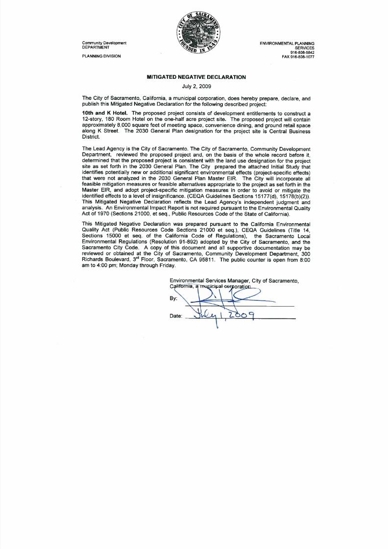
K ST MND 7-1-09
57
Transcript of K ST MND 7-1-09
8/14/2019 K ST MND 7-1-09
http://slidepdf.com/reader/full/k-st-mnd-7-1-09 1/57
8/14/2019 K ST MND 7-1-09
http://slidepdf.com/reader/full/k-st-mnd-7-1-09 2/57
10TH
AND K HOTELINITIAL STUDY/ MITIGATED NEGATIVE DECLARATION
This Initial Study has been prepared by the City of Sacramento, Community Development
Department, 300 Richards Boulevard, Third Floor, Sacramento, CA 95811, pursuant to theCalifornia Environmental Quality Act (Public Resources Code Sections 21000 et seq.), CEQAGuidelines (Title 14, Section 15000 et seq. of the California Code of Regulations) and theSacramento Local Environmental Regulations (Resolution 91-892) adopted by the City of Sacramento.
ORGANIZATION OF THE INITIAL STUDY
This Initial Study is organized into the following sections:
SECTION I - BACKGROUND: Provides summary background information about the projectname, location, sponsor, and the date this Initial Study was completed.
SECTION II - PROJECT DESCRIPTION: Includes a detailed description of the proposedproject.
SECTION III - ENVIRONMENTAL CHECKLIST AND DISCUSSION: This section reviews theproject to determine whether it would have additional significant environmental effects (project-specific effects) that were not evaluated in the Master EIR for the 2030 General Plan.
SECTION IV - ENVIRONMENTAL FACTORS POTENTIALLY AFFECTED: Identifies which
environmental factors were determined to have additional significant environmental effects.
SECTION V - DETERMINATION: Identifies the determination of whether environmental effectsassociated with development of the proposed project are significant, and what, if any, addedenvironmental documentation may be required.
REFERENCES CITED: Identifies source materials that have been consulted in the preparationof the Initial Study.
8/14/2019 K ST MND 7-1-09
http://slidepdf.com/reader/full/k-st-mnd-7-1-09 3/57
1 0 T HA N D K H O T E L
I N I T I A L S T U D Y
P A G E 2
SECTION I - BACKGROUND
Project Name and File Number: 10th and K Hotel
Project Location: The proposed project site is located in DowntownSacramento. The project site is approximately one-half acrein size (20,800 square feet) and is located at the east end of the block on the south side of K Street, between 9 th and 10th Street. The parcels in the project includes 920, 924 and930 K Street (APN 006-0102-012, 006-0102-014 and 006-0102-015)
Project Applicant: 10 & K Investors, LLC1975 Somerdale Circle
Roseville, CA 95661
Project Planner: Sheri Smith, Economic Development915 I Street, Third Floor, Sacramento, CA 95814(916) 808-7204
Environmental Planner: Scott Johnson, Associate Planner 300 Richards Boulevard(916) [email protected]
Date Initial Study Completed: June 30, 2009
This Initial Study was prepared in accordance with the California Environmental Quality Act(CEQA) (Public Resources Code Sections 1500 et seq .). The Lead Agency is the City of Sacramento.
The City of Sacramento, Community Development Department, has reviewed the proposedproject and, on the basis of the whole record before it, has determined that the proposed projectis consistent with the land use designation and the permissible densities and intensities of usefor the project site as set forth in the 2030 General Plan. The proposed project is an anticipatedsubsequent project in the Master EIR prepared for the 2030 General Plan and was adequatelydescribed as included in the Master EIR. See CEQA Guidelines Section 15176(d).
The City has also determined that the discussions of cumulative impacts, growth inducingimpacts, and irreversible significant effects in the 2030 General Plan Master EIR are adequatefor the project. See CEQA Guidelines Section 15178 (a).
The City has prepared the attached Initial Study to identify any potential new or additionalsignificant environmental effects (project-specific effects) that were not analyzed in the Master EIR for the 2030 General Plan. The Initial Study identifies any mitigation measures that will beincorporated to revise the project before the environmental document is released for public
8/14/2019 K ST MND 7-1-09
http://slidepdf.com/reader/full/k-st-mnd-7-1-09 4/57
1 0 T HA N D K H O T E L
I N I T I A L S T U D Y
P A G E 3
review pursuant to CEQA Guidelines Section 15073 in order to avoid or mitigate the identifiedeffects to a level of insignificance. (CEQA Guidelines Section 15178(b)).
As part of the Master EIR process, the City is required to incorporate all feasible mitigationmeasures or feasible alternatives appropriate to the project as set forth in the Master EIR
(CEQA Guidelines Section 15177(d)) The Master EIR mitigation measures that are identified asappropriate are set forth in the applicable technical sections below.
This analysis incorporates by reference the general discussion portions of the 2030 GeneralPlan Master EIR. (CEQA Guidelines Section 15150(a)). The Master EIR is available for publicreview at the City of Sacramento, Community Development Department, 300 RichardsBoulevard, Third Floor, Sacramento, CA 95811, and on the City’s web site at:www.cityofsacramento.org/dsd/planning/environmental-review/eirs/ .
The City is soliciting views of interested persons and agencies on the content of theenvironmental information presented in this document. Due to the time limits mandated by statelaw, your response must be sent at the earliest possible date, but no later than the 20-day
review period ending July 22, 2009.
Please send written responses to:
Scott JohnsonCommunity Development Department
City of Sacramento300 Richards Blvd, 3rd Floor
Sacramento, CA 95811Direct Line: (916) 808-5842
8/14/2019 K ST MND 7-1-09
http://slidepdf.com/reader/full/k-st-mnd-7-1-09 5/57
1 0 T HA N D K H O T E L
I N I T I A L S T U D Y
P A G E 4
SECTION II - PROJECT DESCRIPTION
Section II – Project Description
The proposed project would include demolition of three existing buildings on the project site,and construction and operation of a hotel with 180 rooms and approximately 115,000 squarefeet of interior space. The hotel would include approximately 8,000 square feet of meeting roomspace and retail space on the K Street frontage. The hotel would be twelve stories in height.
The anticipated development schedule calls for a construction start in Spring 2010, withconstruction completed in Winter 2011-2012. Approximately 200 persons would be employedduring construction, and operation of the facility would employ approximately 150 persons,including those employed in the retail space.
Attachments
Attachment A - Vicinity Map
Attachment B - Land Use and Zoning
Attachment C - Site Plan
Attachment D - URBEMIS Summer and Winter Emission Reports
8/14/2019 K ST MND 7-1-09
http://slidepdf.com/reader/full/k-st-mnd-7-1-09 6/57
1 0 T HA N D K H O T E L
I N I T I A L S T U D Y
P A G E 5
SECTION III – ENVIRONMENTAL CHECKLIST AND DISCUSSION
LAND USE, POPULATION AND HOUSING, AGRICULTURAL RESOURCES
Introduction
The California Environmental Quality Act (CEQA) requires the Lead Agency to examine theeffects of a project on the physical conditions that exist within the area that would be affected bythe project. CEQA also requires a discussion of any inconsistency between the proposedproject and applicable general plans and regional plans.
An inconsistency between the proposed project and an adopted plan for land use developmentin a community would not constitute a physical change in the environment. When a projectdiverges from an adopted plan, however, it may affect planning in the community regardinginfrastructure and services, and the new demands generated by the project may result in later physical changes in response to the project.
In the same manner, the fact that a project brings new people or demand for housing to acommunity does not, by itself, change the physical conditions. An increase in population may,however, generate changes in retail demand or demand for governmental services, and thedemand for housing may generate new activity in residential development. Physicalenvironmental impacts that could result from implementing the proposed project are discussedin the appropriate technical sections.
This section of the initial study identifies the applicable land use plans and policies, anddiscusses any inconsistencies between these plans and the proposed project.
Discussion
The project site is located in downtown Sacramento on the K Street Mall. The land useproposed is consistent with the 2030 General Plan land use designation and is consistent withprevious planning for the project vicinity.
The proposed project site is located in the downtown urban core of the City of Sacramento andis not in agricultural production. No commercial agricultural operations exist in the projectvicinity. The proposed project is located in an urbanized portion of the community, and currentlyincludes connections to municipal water, sewer and storm drains. Extensions of utilities to theproject site would not extend service to an area not previously served. The project would notdirectly or induce substantial growth in the project area. No housing units would be displacedor impacted by the proposed project.
8/14/2019 K ST MND 7-1-09
http://slidepdf.com/reader/full/k-st-mnd-7-1-09 7/57
1 0 T HA N D K H O T E L
I N I T I A L S T U D Y
P A G E 6
ENVIRONMENTAL SETTING
The project site is located in Downtown Sacramento, on the south of K Street between 9 th and10th Street. Three Historic Districts – the Capital, Cathedral Square and the Cesar ChavezPlaza Park surround the project site. The Sacramento Urban Design guidelines define 10th Street as the Central Core/Civic Spine and 11th Street (between J and L streets) as a pedestrian
way which designates both as protected view corridors. The proposed project site located inwithin an adopted view corridor at 9th between J and L Street.
STANDARDS OF SIGNIFICANCE
Glare. Glare is considered to be significant if it would be cast in such a way as to cause publichazard or annoyance for a sustained period of time.
Light . Light is considered significant if it would be cast onto oncoming traffic or residential uses.
Answers to Checklist Questions
QUESTION A
The Urban Design Plan protects view corridors from development that would in any way blockviews of landmarks and the spatial continuity of the proposed project area. 10th Street forms aprimary entry to the City from the south, with important views of the Capital and of Capitol Mall,and the Tower Bridge. Across both 10th and K streets and Cesar Chavez Plaza Park represent aconcentration of buildings from the 1910’s and 1030’s that influence their surroundings.
On February 18, 1992 the City Council adopted the Capitol View Protection Requirements whichestablished height restrictions, setback requirements, and parking regulations for properties
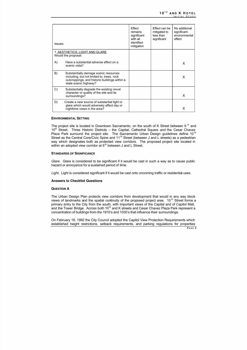
Issues:
Effectremainssignificantwith allidentified
mitigation
Effect can bemitigated toless thansignificant
No additionalsignificantenvironmentaleffect
1. AESTHETICS, LIGHT AND GLAREWould the proposal:
A) Have a substantial adverse effect on ascenic vista?
X
B) Substantially damage scenic resourcesincluding, but not limited to, trees, rockoutcroppings, and historic buildings within astate scenic highway?
X
C) Substantially degrade the existing visualcharacter or quality of the site and itssurroundings? X
D) Create a new source of substantial light or glare which would adversely affect day or nighttime views in the area? X
8/14/2019 K ST MND 7-1-09
http://slidepdf.com/reader/full/k-st-mnd-7-1-09 8/57
1 0 T HA N D K H O T E L
I N I T I A L S T U D Y
P A G E 7
surrounding the State Capitol. The purpose of the Capital View Protection Requirements is toprotect the State Capitol building and the surround grounds of Capitol Park from adverse effectsof nearby development.
The project proposes to demolish three buildings and build a hotel with approximately 180 rooms
with a total of 115, 000 square feet. The proposed project falls within the area designated for height limits and is subject to the ordinance. Building height limits apply to the highest point of thebuilding except for the following unoccupied elements: building caps that serve a decorativefunction, roof-top from the Capitol grounds, and other architectural embellishments approved bythe City Planning Commission through special permits. The proposed project would be restrictedto a 300-foot building height on the site. The proposed project would be approximately 163 feet inheight (including the mechanical penthouse).
The design of the proposed structure would be subject to review by the City. The size of thestructure would be consistent with long-range planning for the downtown area, and would nothave a significant effect on the aesthetics of the area. Development as proposed on this site andin the downtown area generally was anticipated in the 2030 General Plan and aesthetic impacts
were considered and evaluated in the Master EIR. No additional significant environmental effectswould result from the project.
QUESTION B
The proposed project is not located in or nearby any scenic resources including trees, rockoutcroppings and historic buildings within a state scenic highway. There would be no additionalsignificant environmental effects that would result from project development and operation.
QUESTION C
The existing proposed project site is comprised of three parcels: 920, 924 and 930 K Street. 920
K Street was built in 1961, and previously was occupied by a Nail Salon. 920 and 924 K Streetare both located within one building. 930 K Street was built in 1961, and was previously used asa Washington Mutual Bank and office building.
The project proposes to build a 12-story, 180-room hotel which will include approximately 8,000square feet of meeting space, convenience dining and ground floor retail along K Street. Theproposed project would assist with the elimination of blight by developing a key corner of K Streetwith an active use which supports redevelopment activities, provide hotel rooms within walkingdistance of the Convention Center and activates retail space along the K Street Mall. Theproposed project would not substantially degrade the existing visual character or quality of the siteand the surroundings. No additional significant environmental effects would result from the project.
QUESTION D
The proposed 12-story would be visible from neighboring streets and from freeways. High-risebuildings can potentially cause glare and the City of Sacramento requires non-reflectivesurfaces and materials for large projects. Line of sight between the proposed project and I-5 tothe west and I-80 to the north would be partially blocked by intervening high-rise structures.The proposed project would be subject the City of Sacramento’s Urban Design Guidelines toreduce the reflective qualities of the proposed building, and policies of the 2030 General Plan.Because the effect was considered significant in the Master EIR, the Master EIR included

8/14/2019 K ST MND 7-1-09
http://slidepdf.com/reader/full/k-st-mnd-7-1-09 9/57
1 0 T HA N D K H O T E L
I N I T I A L S T U D Y
P A G E 8
Mitigation Measure 6.13-1, set forth below, which ensures that glare will be limited, and reducesthe cumulative impacts to a less-than-significant level. The mitigation also ensures that theproject would not have an additional significant environmental effect.
MITIGATION MEASURES
6.13-1 The City shall amend the Zoning Code to prohibit new development from:
1) using reflective glass that exceeds 50 percent of any building surface and on the groundthree floors;
2) using mirrored glass;3) using black glass that exceeds 25 percent of any surface of a building; and4) using metal building materials that exceed 50 percent of any street-facing surface of a
primarily residential building.
FINDINGS
The project would have no additional significant environmental effects relating to Aesthetics.
8/14/2019 K ST MND 7-1-09
http://slidepdf.com/reader/full/k-st-mnd-7-1-09 10/57
1 0 T HA N D K H O T E L
I N I T I A L S T U D Y
P A G E 9
ENVIRONMENTAL SETTING
The project area is located in the Sacramento Valley Air Basin, which is bounded by the SierraNevada on the east and the Coast Range on the west. Prevailing winds in the project areaoriginate primarily from the southwest. These winds are the result of marine breezes comingthrough the Carquinez Straights. The marine breezes diminish during the winter months, andthe winds from the north occur more frequently at this time. Air quality within the project area
and surround region is largely influenced by urban emission sources.
PM2.5: On December 22, 2008, the EPA administrator approved PM2.5 nonattainment areas,which included Sacramento County and portions of Counties adjacent to Sacramento. Thedesignations will become effective 90 days after publication in the Federal Register, sometimein 2009. Area plans to respond to the health standards are due to EPA in April 2012. Areasmust meet the health standards by April 2014, but the deadline may be extended to April 2019.The Sacramento Metropolitan Air Quality Management District will be working with the CaliforniaAir Resources Board staff to update a technical assessment and modeling of Sacramento's
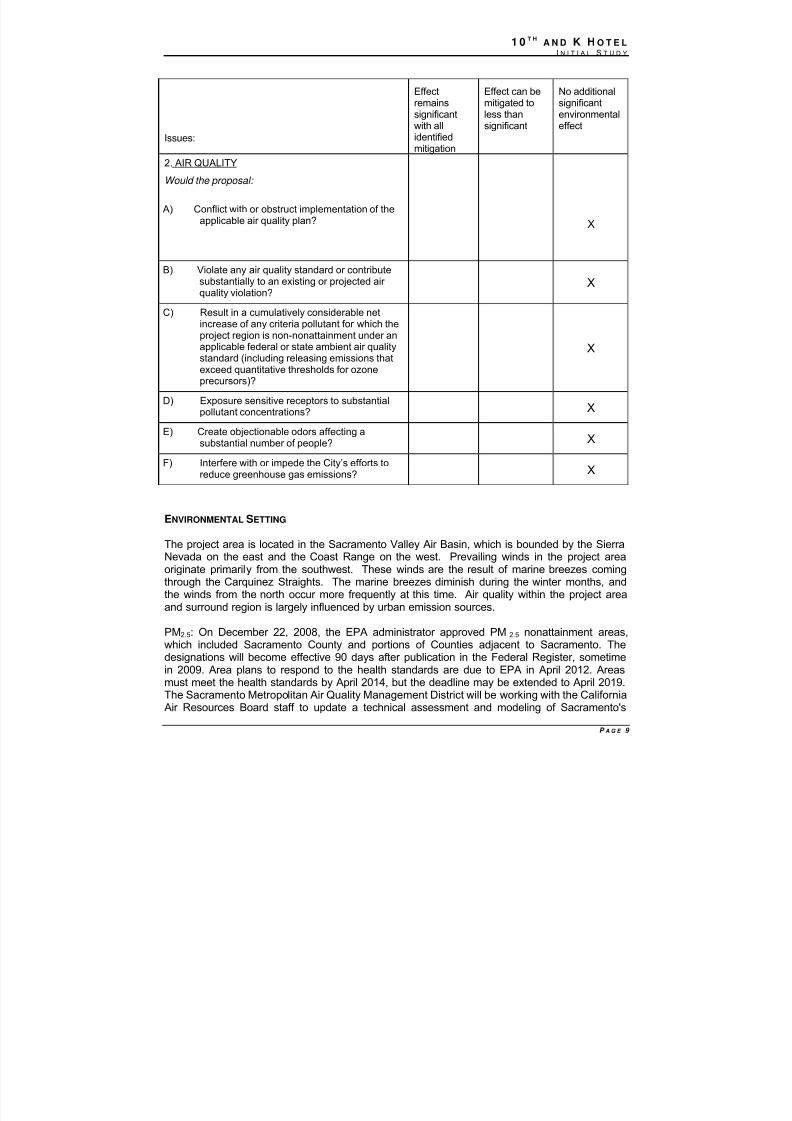
Issues:
Effectremainssignificantwith allidentified
mitigation
Effect can bemitigated toless thansignificant
No additionalsignificantenvironmentaleffect
2. AIR QUALITY
Would the proposal:
A) Conflict with or obstruct implementation of theapplicable air quality plan? X
B) Violate any air quality standard or contributesubstantially to an existing or projected air quality violation?
X
C) Result in a cumulatively considerable netincrease of any criteria pollutant for which theproject region is non-nonattainment under anapplicable federal or state ambient air qualitystandard (including releasing emissions thatexceed quantitative thresholds for ozoneprecursors)?
X
D) Exposure sensitive receptors to substantialpollutant concentrations? X
E) Create objectionable odors affecting asubstantial number of people? X
F) Interfere with or impede the City’s efforts toreduce greenhouse gas emissions? X
8/14/2019 K ST MND 7-1-09
http://slidepdf.com/reader/full/k-st-mnd-7-1-09 11/57
1 0 T HA N D K H O T E L
I N I T I A L S T U D Y
P A G E 10
PM2.5 problems, update the inventory of PM2.5 and precursor emission sources, and determinewhether existing controls are adequate to attain the federal PM2.5 standards by 2014 or 2019. [
STANDARDS OF SIGNIFICANCE
The SMAQMD adopted the following thresholds of significance in 2002:
Ozone and Particulate Matter . An increase of nitrogen oxides (NOx) above 85 pounds per day for short-term effects (construction) would result in a significant impact. An increase of either ozoneprecursor, nitrogen oxides (NOx) or reactive organic gases (ROG), above 65 pounds per day for long-term effects (operation) would result in a significant impact (as revised by SMAQMD, March2002). The threshold of significance for PM10 is a concentration based threshold equivalent to theCalifornia Ambient Air Quality Standard (CAAQS). For PM10, a project would have a significantimpact if it would emit pollutants at a level equal to or greater than five percent of the CAAQS (50micrograms/cubic meter for 24 hours) if there were an existing or projected violation; however, if aproject is below the ROG and NOx thresholds, it can be assumed that the project is below thePM10 threshold as well (SMAQMD, 2004).
Carbon Monoxide. The pollutant of concern for sensitive receptors is carbon monoxide (CO).Motor vehicle emissions are the dominant source of CO in Sacramento County (SMAQMD, 2004).For purposes of environmental analysis, sensitive receptor locations generally include parks,sidewalks, transit stops, hospitals, rest homes, schools, playgrounds and residences. Commercialbuildings are generally not considered sensitive receptors. Carbon monoxide concentrations areconsidered significant if they exceed the 1-hour state ambient air quality standard of 20.0 partsper million (ppm) or the 8-hour state ambient standard of 9.0 ppm (state ambient air qualitystandards are more stringent than their federal counterparts).
MITIGATION MEASURES FROM 2030 GENERAL PLAN MASTER EIR THAT APPLY TO THE PROJECT
The following mitigation measures applicable to air quality were identified in the 2030 GeneralPlan Master EIR, and will be applied to the project:
Greenhouse Gas Emissions and Climate Change: The Master EIR identified numerous policiesincluded in the 2030 General Plan that addressed greenhouse gas emissions and climatechange. See Draft Master EIR, Chapter 8, and pages 8-49 et seq. The Master EIR is availablefor review at the offices of Community Development Department, 300 Richards Boulevard, 3rd Floor, Sacramento, CA during normal business hours, and is also available online at:http://www.cityofsacramento.org/dsd/planning/environmental-review/eirs/ .
Policies identified in the 2030 General Plan include directives relating to sustainabledevelopment patterns and practices, and increasing the viability of pedestrian, bicycle andpublic transit modes. A complete list of policies addressing climate change is included in theMaster EIR in Table 8-6, pages 8-50 et seq; the Final Master EIR included additional discussionof greenhouse gas emissions and climate change in response to written comments. Seechanges to Chapter 8 at Final Master EIR pages 2-19 et seq. See also Letter 2 and response.
8/14/2019 K ST MND 7-1-09
http://slidepdf.com/reader/full/k-st-mnd-7-1-09 12/57
1 0 T HA N D K H O T E L
I N I T I A L S T U D Y
P A G E 11
The City ultimately determined that greenhouse gas emissions that would be generated bydevelopment consistent with the 2030 General Plan would be a significant and unavoidablecumulative impact. The discussion of greenhouse gas emissions and climate change in theDraft Master EIR, Final Master EIR and Errata 2 are incorporated by reference in this InitialStudy. (CEQA Guidelines Section 15150)
ANSWERS TO CHECKLIST QUESTIONS
QUESTION A, B AND D
Cumulative air quality impacts from development consistent with the 2030 General Plan wereadequately addressed in the Master EIR.
Operational Impacts: The URBEMIS 2007 9.2.4 model was used to calculate estimatedemissions for the operation of the proposed project. Based on the estimated emissions fromrunning the URBEMIS model, the proposed project is not likely to exceed the long-termoperational emissions threshold of 65 lbs/day for ROG and NOx. Estimated ROG and NOx,
summer emissions for using the URBEMIS 2007 9.2.4 model were calculated to beapproximately 12.41 lbs/day and 16.32 lbs/day, respectively, which is below the 65 lbs/daythreshold. The estimated ROG and NOx winter emissions for using the URBEMIS 2007 9.2.4model were calculated to be approximately 13.46 lbs/day and 23.79 lbs/day, respectively. SeeAttachment D for the URBEMIS calculations (summer and winter emission reports). The projectwould not have any additional significant environmental effects.
Project-Related Construction Impacts: The URBEMIS 2007 9.2.4 model was used to calculateestimated emissions for the construction of the proposed project. Based on the estimatedemissions from running the URBEMIS model, the proposed project is not likely to exceed theshort-term emissions threshold of 85 lbs/day for NOx. Estimated NOx summer and winter emissions using the URBEMIS 2007 9.2.4 model were calculated to be approximately 45.12lbs/day, which is below the 85 lbs/day threshold.
The SMAQMD 2004 Guide to Air Quality Assessment states on page 3-2 that if the project’sNOx mass emissions from heavy-duty, mobile sources are determined not potentially significantusing the recommend methodologies for estimated emissions (Manual Calculation, URBEMIS,and Roadway Construction Model), the Lead Agency may assume that exhaust emissions of other pollutants from operation of construction equipment and worker commute vehicles arealso not significant. The URBEMIS 2007 model indicated that the project would not exceed theNOx threshold and, based on the guidance of the air district, the analysis of other criteriapollutant emissions is not included in this discussion.
Construction activities would be subject to the SMAQMD’s Rule 403 on Fugitive Dust, whichprovides that contractors shall take every reasonable precaution not to cause or allow theemissions of fugitive dust from being airborne beyond the property line from which the emissionoriginates, from any construction, handling or storage activity, or any excavation, grading,clearing of land or solid waste disposal operation. Reasonable precautions include, but are notlimited to:
● the use of water or chemicals for control of dust, where possible, during constructionoperations (including roadways), or during the clearing of land;● the application of asphalt, oil, water, or suitable chemicals on dirt roads, materialsstockpiles, and other surfaces, which can give rise to airborne dusts;
8/14/2019 K ST MND 7-1-09
http://slidepdf.com/reader/full/k-st-mnd-7-1-09 13/57
1 0 T HA N D K H O T E L
I N I T I A L S T U D Y
P A G E 12
● other means approved by the Air Pollution Control Officer.
QUESTION C
The proposed project would not result in significant air quality impacts associated with short-
term construction and long-term operation emissions of ozone-precursor pollutants (ROG andNOx) and airborne particulate matter (PM10 and PM2.5). Ozone impacts are the result of the
cumulative emissions from stationary, area, and mobile sources located within the region, aswell as, transport from outside the region. Ozone is formed by the chemical reaction of theozone-precursor pollutants ROG and NOx in the presences of sunlight, with the highest ozoneconcentrations occurring during the warmer summer months. The cumulative contributions of ozone-precursor pollutants from multiple sources result in severe ozone problems, which canadversely affect human health. The Sacramento Valley Air Basin (SVAB) is classified non-attainment for ozone and PM10.
For evaluation of cumulative ozone and PM impacts, the SMAQMD recommends that theproject-level significance thresholds be relied upon for determination of cumulative air quality
impacts. The proposed project does not generate emissions of either ozone precursor pollutants (i.e., ROG and NOx) or PM10 and not would exceed the short-term or long-term
thresholds. The project would not have any additional significant environmental effects.
QUESTION D
The 2030 General Plan and Master EIR included provisions to ensure that the City considersexposure to toxic air contaminants when approving new development in the vicinity of freewaysand major roadways. In general, these concerns arise for developments within 500 feet of suchroadways. The proposed project includes proposals for new residential units no closer than 500feet to Interstate 5 and almost all residential units are well beyond the 500-foot distance.Development of the project site as proposed would not require a health risk assessment andwould not generate any additional significant environmental effects for relating to toxic air contaminants.
QUESTION E
The project site is located on a main thoroughfare in the downtown area of the City of Sacramento, and would be exposed to odors normally associated with a densely urbanizedenvironment. Project construction and operation would generate odors normally associated withsuch activities. The project proposes land uses that are consistent with the General Plan landuse for the site. The project was included in the analysis of cumulative effects set forth in theMaster EIR, and the project would not have any additional significant environmental effectsregarding odors.
QUESTION F
The Master EIR includes extensive discussion of the potential effects of greenhouse gasemissions. The Master EIR discussions regarding climate change are incorporated here byreference. See for example:
Draft EIR: 6.1 Air Quality (Page 6.1-1)Final EIR: City Climate Change master Response (Page 4-1)Errata No. 2: Climate Change (Page 12)
8/14/2019 K ST MND 7-1-09
http://slidepdf.com/reader/full/k-st-mnd-7-1-09 14/57
1 0 T HA N D K H O T E L
I N I T I A L S T U D Y
P A G E 13
These documents are available at: www.cityofsacramento.org/dsd/planning/environmental-review/eirs/ and at the offices of the Community Development Department at 300 RichardsBoulevard, Sacramento, California.
The Master EIR concluded that greenhouse gas emissions that could be emitted bydevelopment that is consistent with the 2030 General Plan would be cumulatively considerableand unavoidable (Errata No. 2, Page 12).
Review of project greenhouse gas emissions is set forth below.
Short-term Construction Emissions
During construction of the project greenhouse gas emissions would be emitted from theoperation of construction equipment and from worker and building supply vendor vehicles. Theproject area source and construction total CO2 emissions generated by the project would beapproximately 300 metric tons per year. These emissions would equate to approximately
0.00006 percent of the estimated GHG emissions for all sources in California (483 million metrictons) (CARB 2009). Construction would not exceed two years.
Long-term Operational Emissions
The largest source of greenhouse gas emissions associated with the proposed project would beon- and off-site motor vehicle use. CO2 emissions, the primary greenhouse gas emission frommobile sources, are directly related to the quantity of fuel consumed. CO2 emissions duringoperation of the project at full build-out would be approximately 2,215 metric tons, whichequates to 0.00046 percent of California’s total emissions.
The project site is located within the City limits, downtown along K Street and has ready access
to bus and light rail service. This area consists of a variety of retail and restaurant locations andis in close proximity to the Sacramento Convention Center helping to minimize vehicle trips.
Buildings constructed as part of the project would be required to comply with current Californiabuilding codes that enforce energy efficiency.
The project is consistent with the City’s goals as set forth in the 2030 General Plan and MEIRrelating to reduction of greenhouse gas emissions. The project would not impede the City’sefforts to comply with AB32 requirements. The project would not have any significant additionalenvironmental effects relating to greenhouse gas emissions or climate change.
Findings
The project would have no additional significant environmental effects relating to air quality.
8/14/2019 K ST MND 7-1-09
http://slidepdf.com/reader/full/k-st-mnd-7-1-09 15/57
1 0 T HA N D K H O T E L
I N I T I A L S T U D Y
P A G E 14
ENVIRONMENTAL SETTING
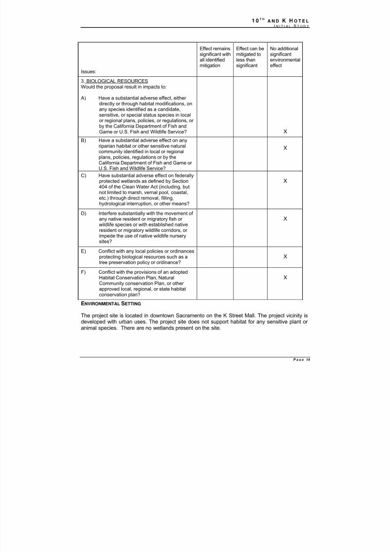
The project site is located in downtown Sacramento on the K Street Mall. The project vicinity isdeveloped with urban uses. The project site does not support habitat for any sensitive plant or animal species. There are no wetlands present on the site.
Issues:
Effect remainssignificant withall identifiedmitigation
Effect can bemitigated toless thansignificant
No additionalsignificantenvironmentaleffect
3. BIOLOGICAL RESOURCESWould the proposal result in impacts to:
A) Have a substantial adverse effect, either directly or through habitat modifications, onany species identified as a candidate,sensitive, or special status species in localor regional plans, policies, or regulations, or by the California Department of Fish andGame or U.S. Fish and Wildlife Service? X
B) Have a substantial adverse effect on anyriparian habitat or other sensitive naturalcommunity identified in local or regionalplans, policies, regulations or by theCalifornia Department of Fish and Game or U.S. Fish and Wildlife Service?
X
C) Have substantial adverse effect on federallyprotected wetlands as defined by Section404 of the Clean Water Act (including, butnot limited to marsh, vernal pool, coastal,etc.) through direct removal, filling,hydrological interruption, or other means?
X
D) Interfere substantially with the movement of any native resident or migratory fish or
wildlife species or with established nativeresident or migratory wildlife corridors, or impede the use of native wildlife nurserysites?
X
E) Conflict with any local policies or ordinancesprotecting biological resources such as atree preservation policy or ordinance?
X
F) Conflict with the provisions of an adoptedHabitat Conservation Plan, NaturalCommunity conservation Plan, or other approved local, regional, or state habitatconservation plan?
X
8/14/2019 K ST MND 7-1-09
http://slidepdf.com/reader/full/k-st-mnd-7-1-09 16/57
1 0 T HA N D K H O T E L
I N I T I A L S T U D Y
P A G E 15
STANDARDS OF SIGNIFICANCE
For purposes of this environmental document, an impact would be significant if any of the
following conditions or potential thereof, would result with implementation of the proposed project:
• Creation of a potential health hazard, or use, production or disposal of materials that wouldpose a hazard to plant or animal populations in the area affected;
• Substantial degradation of the quality of the environment, reduction of the habitat, reductionof population below self-sustaining levels of threatened or endangered species of plant or animal;
• Affect other species of special concern to agencies or natural resource organizations (suchas regulatory waters and wetlands); or
•
Violation of the Heritage Tree Ordinance (City Code 12.64.040).
ANSWERS TO CHECKLIST QUESTIONS
QUESTION A THROUGH F
The site has been completely disturbed and developed. The project would demolish existingbuildings on the site, and construct a new hotel. The project vicinity is developed with urbanuses. The project site does not support habitat for any sensitive plant or animal species. Thereare no wetlands present on the site. The project would not have any additional significantenvironmental effects.
MITIGATION MEASURES
None required.
FINDINGS
The project would have no additional significant environmental effects relating to BiologicalResources.
8/14/2019 K ST MND 7-1-09
http://slidepdf.com/reader/full/k-st-mnd-7-1-09 17/57
1 0 T HA N D K H O T E L
I N I T I A L S T U D Y
P A G E 16
Issues:
Effectremainssignificant
with allidentifiedmitigation
Effect can bemitigated toless than
significant
No additionalsignificantenvironmental
effect
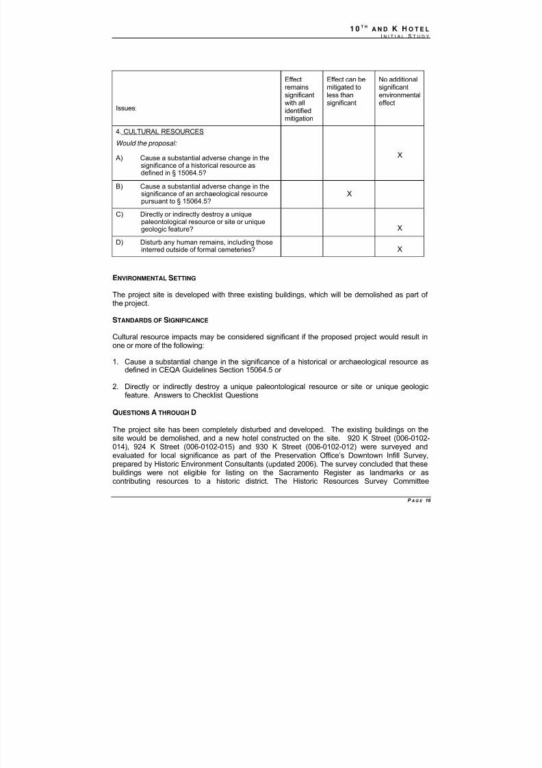
4. CULTURAL RESOURCES
Would the proposal:
A) Cause a substantial adverse change in thesignificance of a historical resource asdefined in § 15064.5?
X
B) Cause a substantial adverse change in thesignificance of an archaeological resourcepursuant to § 15064.5?
X
C) Directly or indirectly destroy a uniquepaleontological resource or site or uniquegeologic feature? X
D) Disturb any human remains, including thoseinterred outside of formal cemeteries? X
ENVIRONMENTAL SETTING
The project site is developed with three existing buildings, which will be demolished as part of the project.
STANDARDS OF SIGNIFICANCE
Cultural resource impacts may be considered significant if the proposed project would result inone or more of the following:
1. Cause a substantial change in the significance of a historical or archaeological resource asdefined in CEQA Guidelines Section 15064.5 or
2. Directly or indirectly destroy a unique paleontological resource or site or unique geologicfeature. Answers to Checklist Questions
QUESTIONS A THROUGH D
The project site has been completely disturbed and developed. The existing buildings on thesite would be demolished, and a new hotel constructed on the site. 920 K Street (006-0102-014), 924 K Street (006-0102-015) and 930 K Street (006-0102-012) were surveyed andevaluated for local significance as part of the Preservation Office’s Downtown Infill Survey,prepared by Historic Environment Consultants (updated 2006). The survey concluded that thesebuildings were not eligible for listing on the Sacramento Register as landmarks or ascontributing resources to a historic district. The Historic Resources Survey Committee
8/14/2019 K ST MND 7-1-09
http://slidepdf.com/reader/full/k-st-mnd-7-1-09 18/57
1 0 T HA N D K H O T E L
I N I T I A L S T U D Y
P A G E 17
concurred with this recommendation. The proposed demolition would not have any additionalsignificant environmental effect on historic resources.
Any new excavation as part of the proposed project could affect cultural resources notpreviously discovered, and this would be a project-specific effect. The mitigation identified below
would reduce the effect to a less-than-significant level.
MITIGATION MEASURES
CR-1: In the event that any prehistoric subsurface archeological features or deposits,including locally darkened soil (“midden”), that could conceal cultural deposits, animalbone, obsidian and/or mortars are discovered during construction-related earth-movingactivities, all work within 50 meters of the resources shall be halted, and the City shallconsult with a qualified archeologist to assess the significance of the find. Archeologicaltest excavations shall be conducted by a qualified archeologist to aid in determining thenature and integrity of the find. If the find is determined to be significant by the qualifiedarcheologist, representatives of the City and the qualified archeologist shall coordinate to
determine the appropriate course of action. All significant cultural materials recoveredshall be subject to scientific analysis and professional museum curation. In addition, areport shall be prepared by the qualified archeologist according to current professionalstandards.
CR-2: If a Native American site is discovered, the evaluation process shallinclude consultation with the appropriate Native American representatives.
a. If Native American archeological, ethnographic, or spiritual resources areinvolved, all identification and treatment shall be conducted by qualifiedarcheologists, who are certified by the Society of Professional Archeologists(SOPA) and/or meet the federal standards as stated in the Code of Federal
Regulations (36 CFR 61), and Native American representatives, who areapproved by the local Native American community as scholars of the culturaltraditions.
b. In the event that no such Native American is available, persons whorepresent tribal governments and/or organizations in the locale in whichresources could be affected shall be consulted. If historic archeological sitesare involved, all identified treatment is to be carried out by qualified historicalarcheologists, who shall meet either Register of Professional Archeologists(RPA), or 36 CFR 61 requirements.
CR-3: If a human bone or bone of unknown origin is found during construction,all work shall stop in the vicinity of the find, and the County Coroner shall becontacted immediately. If the remains are determined to be Native American, thecoroner shall notify the Native American Heritage Commission, who shall notifythe person most likely believed to be a descendant. The most likely descendantshall work with the contractor to develop a program for re-internment of thehuman remains and any associated artifacts. No additional work is to take placewithin the immediate vicinity of the find until the identified appropriate actionshave taken place.

8/14/2019 K ST MND 7-1-09
http://slidepdf.com/reader/full/k-st-mnd-7-1-09 19/57
1 0 T HA N D K H O T E L
I N I T I A L S T U D Y
P A G E 18
Implementation of these mitigation measures would reduce the impact to a less-than-significantlevel.
FINDINGS
All additional significant environmental effects of the project relating to Cultural Resources canbe mitigated to a less-than-significant level.
8/14/2019 K ST MND 7-1-09
http://slidepdf.com/reader/full/k-st-mnd-7-1-09 20/57
1 0 T HA N D K H O T E L
I N I T I A L S T U D Y
P A G E 19
Issues:
Effectremainssignificant
with allidentifiedmitigation
Effect can bemitigated toless than
significant
No additionalsignificantenvironmental
effect
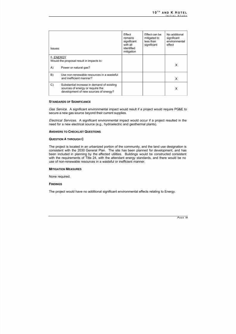
5. ENERGYWould the proposal result in impacts to:
A) Power or natural gas?X
B) Use non-renewable resources in a wastefuland inefficient manner? X
C) Substantial increase in demand of existingsources of energy or require thedevelopment of new sources of energy? X
STANDARDS OF SIGNIFICANCE
Gas Service . A significant environmental impact would result if a project would require PG&E tosecure a new gas source beyond their current supplies.
Electrical Services. A significant environmental impact would occur if a project resulted in theneed for a new electrical source (e.g., hydroelectric and geothermal plants).
ANSWERS TO CHECKLIST QUESTIONS
QUESTION A THROUGH C
The project is located in an urbanized portion of the community, and the land use designation isconsistent with the 2030 General Plan. The site has been planned for development, and hasbeen included in planning by the affected utilities. Buildings would be constructed consistentwith the requirements of Title 24, with the attendant energy standards, and there would be nouse of non-renewable resources in a wasteful or inefficient manner.
MITIGATION MEASURES
None required.
FINDINGS
The project would have no additional significant environmental effects relating to Energy.
8/14/2019 K ST MND 7-1-09
http://slidepdf.com/reader/full/k-st-mnd-7-1-09 21/57
1 0 T HA N D K H O T E L
I N I T I A L S T U D Y
P A G E 20
Issues:
Effectremainssignificantwith allidentified
mitigation
Effect can bemitigated to lessthan significant
No additionalsignificantenvironmentaleffect
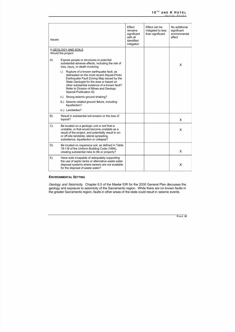
6.GEOLOGY AND SOILSWould the project:
A) Expose people or structures to potentialsubstantial adverse effects, including the risk of loss, injury, or death involving:
i.) Rupture of a known earthquake fault, asdelineated on the most recent Alquist-PrioloEarthquake Fault Zoning Map issued by theState Geologist for the area or based onother substantial evidence of a known fault?
Refer to Division of Mines and GeologySpecial Publication 42.
ii.) Strong seismic ground shaking?
iii.) Seismic-related ground failure, includingliquefaction?
iv.) Landslides?
X
B) Result in substantial soil erosion or the loss of topsoil? X
C) Be located on a geologic unit or soil that isunstable, or that would become unstable as aresult of the project, and potentially result in on-or off-site landslide, lateral spreading,subsidence, liquefaction or collapse?
X
D) Be located on expansive soil, as defined in Table18-1-B of the Uniform Building Code (1994),creating substantial risks to life or property? X
E) Have soils incapable of adequately supportingthe use of septic tanks or alternative waste water disposal systems where sewers are not availablefor the disposal of waste water?
X
ENVIRONMENTAL SETTING
Geology and Seismicity . Chapter 6.5 of the Master EIR for the 2030 General Plan discusses thegeology and exposure to seismicity of the Sacramento region. While there are no known faults inthe greater Sacramento region, faults in other areas of the state could result in seismic events.
8/14/2019 K ST MND 7-1-09
http://slidepdf.com/reader/full/k-st-mnd-7-1-09 22/57
1 0 T HA N D K H O T E L
I N I T I A L S T U D Y
P A G E 21
STANDARDS OF SIGNIFICANCE
For the purposes of this analysis, an impact is considered significant if it allows a project to bebuilt that will either introduce geologic or seismic hazards by allowing the construction of theproject on such a site without protection against those hazards.
ANSWERS TO CHECKLIST QUESTIONS
QUESTION A THOUGH E
The Master EIR discussed the potential for exposure to seismic and geologic events. Theproject does not expose persons or property to risks that were not examined in the Master EIR,and would not have additional significant environmental effects.
MITIGATION MEASURES
None required.
FINDINGS
The project would have no additional significant environmental effects relating to Geology andSoils.
8/14/2019 K ST MND 7-1-09
http://slidepdf.com/reader/full/k-st-mnd-7-1-09 23/57
1 0 T HA N D K H O T E L
I N I T I A L S T U D Y
P A G E 22
Issues:
Effectremainssignificantwith allidentified
mitigation
Effect can bemitigated toless thansignificant
No additionalsignificantenvironmentaleffect
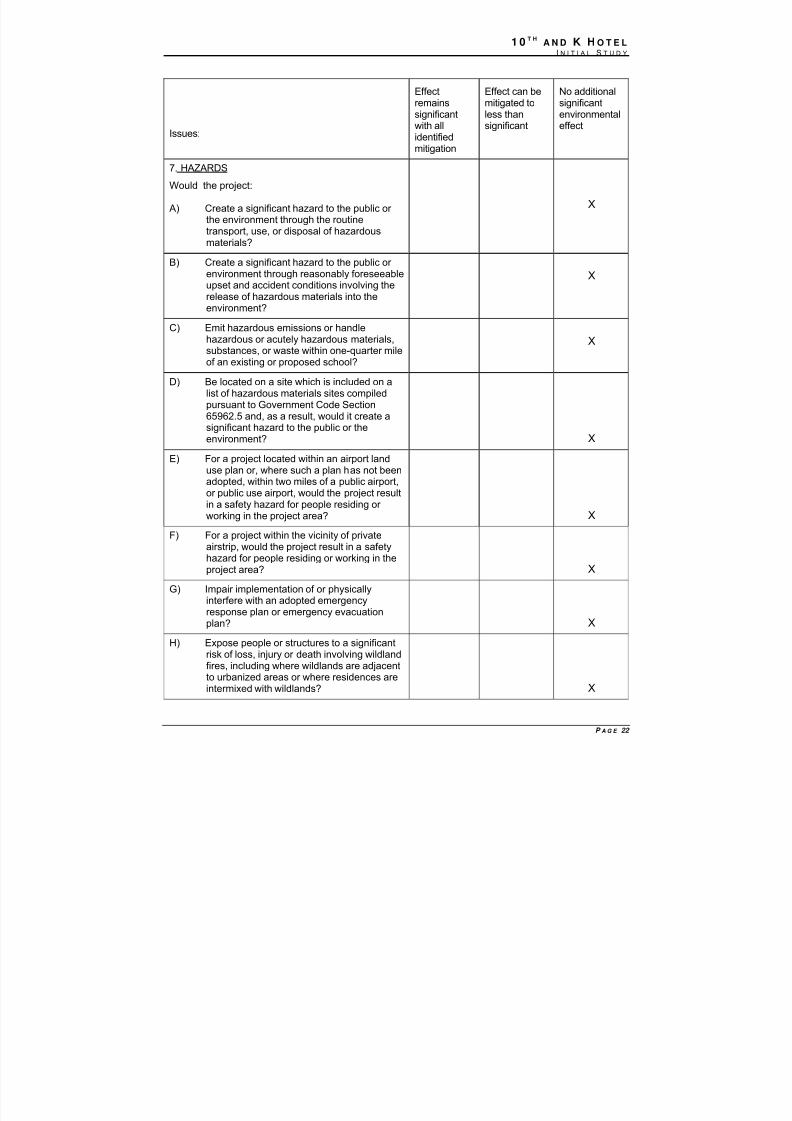
7. HAZARDS
Would the project:
A) Create a significant hazard to the public or the environment through the routinetransport, use, or disposal of hazardousmaterials?
X
B) Create a significant hazard to the public or environment through reasonably foreseeableupset and accident conditions involving therelease of hazardous materials into theenvironment?
X
C) Emit hazardous emissions or handlehazardous or acutely hazardous materials,substances, or waste within one-quarter mileof an existing or proposed school?
X
D) Be located on a site which is included on alist of hazardous materials sites compiledpursuant to Government Code Section65962.5 and, as a result, would it create asignificant hazard to the public or theenvironment? X
E) For a project located within an airport landuse plan or, where such a plan has not beenadopted, within two miles of a public airport,or public use airport, would the project resultin a safety hazard for people residing or working in the project area? X
F) For a project within the vicinity of privateairstrip, would the project result in a safetyhazard for people residing or working in theproject area? X
G) Impair implementation of or physicallyinterfere with an adopted emergencyresponse plan or emergency evacuationplan? X
H) Expose people or structures to a significantrisk of loss, injury or death involving wildlandfires, including where wildlands are adjacentto urbanized areas or where residences areintermixed with wildlands? X
8/14/2019 K ST MND 7-1-09
http://slidepdf.com/reader/full/k-st-mnd-7-1-09 24/57
1 0 T HA N D K H O T E L
I N I T I A L S T U D Y
P A G E 23
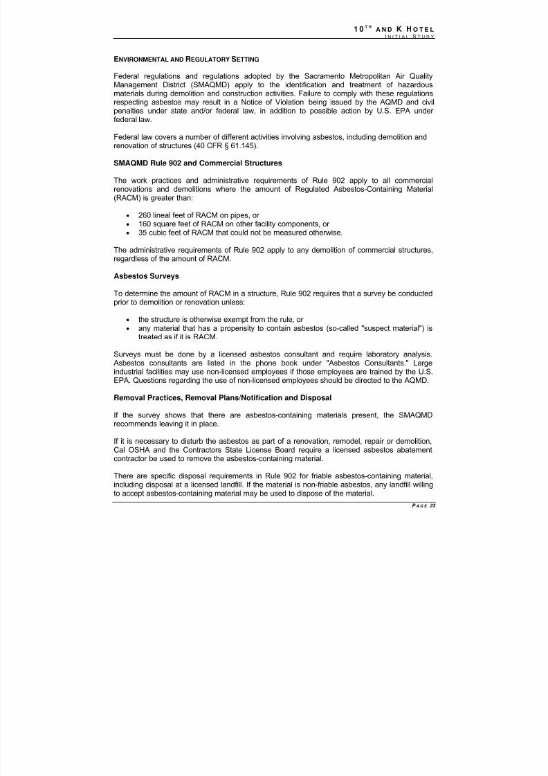
ENVIRONMENTAL AND REGULATORY SETTING
Federal regulations and regulations adopted by the Sacramento Metropolitan Air QualityManagement District (SMAQMD) apply to the identification and treatment of hazardousmaterials during demolition and construction activities. Failure to comply with these regulations
respecting asbestos may result in a Notice of Violation being issued by the AQMD and civilpenalties under state and/or federal law, in addition to possible action by U.S. EPA under federal law.
Federal law covers a number of different activities involving asbestos, including demolition andrenovation of structures (40 CFR § 61.145).
SMAQMD Rule 902 and Commercial Structures
The work practices and administrative requirements of Rule 902 apply to all commercialrenovations and demolitions where the amount of Regulated Asbestos-Containing Material(RACM) is greater than:
• 260 lineal feet of RACM on pipes, or • 160 square feet of RACM on other facility components, or • 35 cubic feet of RACM that could not be measured otherwise.
The administrative requirements of Rule 902 apply to any demolition of commercial structures,regardless of the amount of RACM.
Asbestos Surveys
To determine the amount of RACM in a structure, Rule 902 requires that a survey be conductedprior to demolition or renovation unless:
• the structure is otherwise exempt from the rule, or • any material that has a propensity to contain asbestos (so-called "suspect material") is
treated as if it is RACM.
Surveys must be done by a licensed asbestos consultant and require laboratory analysis.Asbestos consultants are listed in the phone book under "Asbestos Consultants." Largeindustrial facilities may use non-licensed employees if those employees are trained by the U.S.EPA. Questions regarding the use of non-licensed employees should be directed to the AQMD.
Removal Practices, Removal Plans/Notification and Disposal
If the survey shows that there are asbestos-containing materials present, the SMAQMDrecommends leaving it in place.
If it is necessary to disturb the asbestos as part of a renovation, remodel, repair or demolition,Cal OSHA and the Contractors State License Board require a licensed asbestos abatementcontractor be used to remove the asbestos-containing material.
There are specific disposal requirements in Rule 902 for friable asbestos-containing material,including disposal at a licensed landfill. If the material is non-friable asbestos, any landfill willingto accept asbestos-containing material may be used to dispose of the material.
8/14/2019 K ST MND 7-1-09
http://slidepdf.com/reader/full/k-st-mnd-7-1-09 25/57
1 0 T HA N D K H O T E L
I N I T I A L S T U D Y
P A G E 24
The site and vicinity have been designated for urban development, and the area is experiencingcontinuing construction as sites are built out. The site and the vicinity are served with urbanservices.
STANDARDS OF SIGNIFICANCE
For the purposes of this document, an impact is considered significant if the proposed projectwould:
• expose people (e.g., residents, pedestrians, construction workers) to existingcontaminated soil during construction activities;
• expose people (e.g., residents, pedestrians, construction workers) to asbestos-containingmaterials or other hazardous materials; or
• expose people (e.g., residents, pedestrians, construction workers) to existingcontaminated groundwater during dewatering activities.
ANSWERS TO CHECKLIST QUESTIONS
QUESTION A
Construction of the proposed project would involve the demolition and removal of the existingbuildings. Because the buildings were constructed when asbestos and lead-based paint wereused in building construction (prior to 1978), there is a possibility that the building componentscontain asbestos or lead-based paint. The below mitigation measure would ensure the asbestoscontaining building materials (ACBM), lead-based paint, or other hazardous substances inbuilding components are identified, removed, packaged, and disposed of in accordance withapplicable state laws and regulations. This would minimize the risk of an accidental release of
hazardous substances that could adversely affect human health of the environment. Withimplementation of the mitigation measure(s), the project would not have any additionalsignificant environmental effect.
QUESTIONS B THROUGH H
As a site located in an urban area, the project site is fully served with urban services, includingpolice, fire and stormwater drainage. The exposure to hazards experienced by persons andproperty on the site would be consistent with the level expected in normal urban development.The Master EIR evaluated such exposure, and the project site, with the exception of exposureto flood risk (see Hydrology section below) would not have any additional significant
environmental effects.
MITIGATION MEASURES
Hazards 1:
(a) Prior to any demolition activities, the project applicant shall submit a written plan to theSacramento County Environmental Management Department (SCEMD) describingmethods to be used to: (1) identify locations that could contain hazardous residues (e.g.,mercury in sink traps); (2) remove plumbing fixtures known to contain or potentially
8/14/2019 K ST MND 7-1-09
http://slidepdf.com/reader/full/k-st-mnd-7-1-09 26/57
1 0 T HA N D K H O T E L
I N I T I A L S T U D Y
P A G E 25
containing hazardous substances; (3) determine the waste classification for the debris;(4) package contaminated items and wastes; and (50 identify disposal site(s) permittedto accept such wastes. Demolition shall not occur until the plan has been accepted bythe City and SCEMD and all hazardous components have been removed to thesatisfaction of the City and SCEMD staff.
(b) Prior to any demolition activities, the project applicant shall retain a qualifiedenvironmental specialist (e.g., a Registered Environmental Assessor or similarlyqualified individual) to inspect all existing buildings subject to demolition for the presenceof PCBs, mercury, or other hazardous materials. The project applicant shall submit thereport to the City, together with an explanation of how the project would mitigate anyissues identified in the report. If found at levels that require special handling (i.e.,removal and disposal as hazardous waste), the applicant shall manage these materialsas required by law and according to federal and state regulations and guidelines,including those of DTSC, SCEMD, Cal/OSHA, and any other agency with jurisdictionover these hazardous materials.
(c) Prior to demolition activities at the site, the applicant/developer shall survey the existingbuildings for asbestos containing material (ACM) and lead containing paint. If discovered, all applicable federal, State and local regulations including SMAQMD Rules902 and 304 (pertaining to asbestos abatement and related fees), Construction SafetyOrders 1529 (pertaining to Asbestos Containing Building Materials (ACBM)) and 1532.1(pertaining to lead based paint) from Title 8 of the CCR, Part 61, Subpart M of the CFR(pertaining to ACBM), and lead-based paint exposure guidelines provided by the U.S.Dept. of Housing and Urban Development (HUD) regarding removal and disposal of ACM and lead containing paint shall be complied with. ACBM and lead-based paintabatement must be performed and monitored by contractors with appropriatecertification from the California Department of Health Services.
(d) If necessary, a report of program results shall be made by a State licensed and qualifiedengineer and submitted to the Sacramento County Emergency ManagementDepartment (SCEMD) and Department of Toxic Substance Control (DTSC). If thefindings of the soil analyses indicate levels of contaminants above those acceptable tothe SECMD or DTSC, then a remediation program shall be prepared to excavate andremove the contaminated soils to the appropriate solid waste disposal facility.
FINDINGS
The project would have no additional significant environmental effects relating to Hazards.
8/14/2019 K ST MND 7-1-09
http://slidepdf.com/reader/full/k-st-mnd-7-1-09 27/57
1 0 T HA N D K H O T E L
I N I T I A L S T U D Y
P A G E 26
Issues:
Effectremainssignificantwith allidentifiedmitigation
Effect can bemitigated toless thansignificant
No additionalsignificantenvironmentaleffect
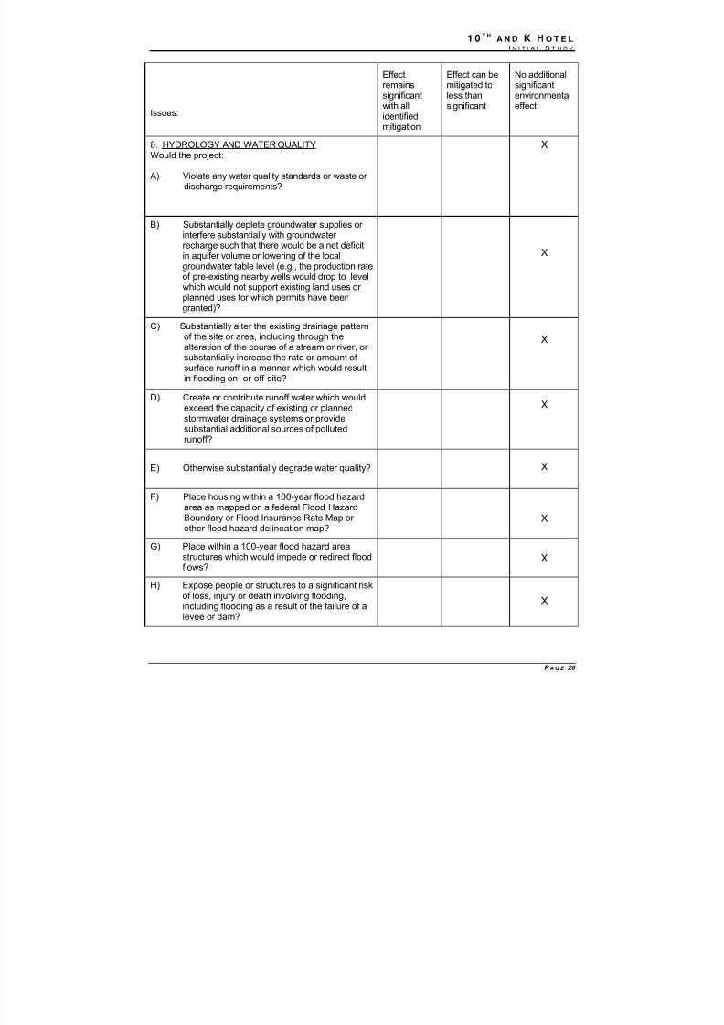
8. HYDROLOGY AND WATER QUALITYWould the project:
A) Violate any water quality standards or waste or discharge requirements?
X
B) Substantially deplete groundwater supplies or interfere substantially with groundwater recharge such that there would be a net deficitin aquifer volume or lowering of the localgroundwater table level (e.g., the production rate
of pre-existing nearby wells would drop to levelwhich would not support existing land uses or planned uses for which permits have beengranted)?
X
C) Substantially alter the existing drainage patternof the site or area, including through thealteration of the course of a stream or river, or substantially increase the rate or amount of surface runoff in a manner which would resultin flooding on- or off-site?
X
D) Create or contribute runoff water which wouldexceed the capacity of existing or planned
stormwater drainage systems or providesubstantial additional sources of pollutedrunoff?
X
E) Otherwise substantially degrade water quality? X
F) Place housing within a 100-year flood hazardarea as mapped on a federal Flood HazardBoundary or Flood Insurance Rate Map or other flood hazard delineation map?
X
G) Place within a 100-year flood hazard area
structures which would impede or redirect floodflows?
X
H) Expose people or structures to a significant riskof loss, injury or death involving flooding,including flooding as a result of the failure of alevee or dam?
X
8/14/2019 K ST MND 7-1-09
http://slidepdf.com/reader/full/k-st-mnd-7-1-09 28/57
1 0 T HA N D K H O T E L
I N I T I A L S T U D Y
P A G E 27
ENVIRONMENTAL SETTING
STANDARDS OF SIGNIFICANCE
Water Quality. For purposes of this environmental document, an impact is considered
significant if the proposed project would substantially degrade water quality and violate anywater quality objectives set by the State Water Resources Control Board, due to increasedsediments and other contaminants generated by consumption and/or operation activities.
Flooding. For purposes of this environmental document, an impact is considered significant if the proposed project substantially increases exposure of people and/or property to the risk of injury and damage in the event of a 100-year flood.
ANSWERS TO CHECKLIST QUESTIONS
QUESTION A- E
The City is required to enforce water quality protection measures during construction, and these provisions would be implemented as part of the project. The project includes improvements toensure that stormwater is adequately retained and treated prior to discharge, and no additionalsignificant effects would result from the project regarding water quality.
QUESTION F-H
The Master EIR evaluated the cumulative effects of flood and drainage. The proposed project islocated in an area with 100-year flood protection. No additional significant environ mental effectswould be present.
MITIGATION MEASURES
None required.
FINDINGS
No additional significant environmental effects would occur as a result of the projectconstruction and operation.
8/14/2019 K ST MND 7-1-09
http://slidepdf.com/reader/full/k-st-mnd-7-1-09 29/57
1 0 T HA N D K H O T E L
I N I T I A L S T U D Y
P A G E 28
Issues:
Effectremainssignificantwith allidentifiedmitigation
Effect can bemitigated toless thansignificant
No additionalsignificantenvironmentaleffect
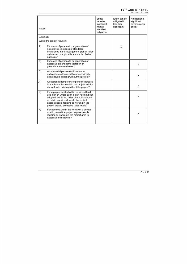
9. NOISE
Would the project result in:
A) Exposure of persons to or generation of noise levels in excess of standardsestablished in the local general plan or noiseordinance, or applicable standards of other agencies?
X
B) Exposure of persons to or generation of excessive groundborne vibration or groundborne noise levels?
X
C) A substantial permanent increase inambient noise levels in the project vicinityabove levels existing without the project?
X
D) A substantial temporary or periodic increasein ambient noise levels in the project vicinityabove levels existing without the project? X
E) For a project located within an airport landuse plan or, where such a plan has not beenadopted, within two miles of a public airportor public use airport, would the projectexpose people residing or working in theproject area to excessive noise levels?
X
F) For a project within the vicinity of a privateairstrip, would the project expose peopleresiding or working in the project area toexcessive noise levels?
X
8/14/2019 K ST MND 7-1-09
http://slidepdf.com/reader/full/k-st-mnd-7-1-09 30/57
1 0 T HA N D K H O T E L
I N I T I A L S T U D Y
P A G E 29
ENVIRONMENTAL SETTING
The project is located at the southwest corner of the intersection of 10th and K streets in thedowntown area of the Central City. The area consists primarily of commercial, office and retailuses along with government uses. K Street is closed to vehicular traffic westward from the
Convention Center at 13th Street. K Street extends six blocks west to the Downtown Plaza.Along the way there are shops, bars, sidewalk cafes, movie theaters and restaurants. 10th Street is a three-lane, one-way, northbound street that travels in front of the State Capitol andfurther to the north passes Cesar Chavez Park and Sacramento City Hall. Regional Transit lightrail runs along K Street in the vicinity of the project, and Regional Transit operates bus routesthat traverse the project area.
STANDARDS OF SIGNIFICANCE
Thresholds of significance are those established by the Title 24 standards and by the City'sGeneral Plan Noise Policies and the City Noise Ordinance. Noise and vibration impacts resultingfrom the implementation of the proposed project would be considered significant if they cause any
of the following results:
• Exterior noise levels at the proposed project exceeding the upper value of the normallyacceptable category for various land uses caused by noise level increases due to theproject. (2030 General Plan, Table EC-1, 2009).
• Residential interior noise levels of Ldn 45 dB or greater caused by noise level increasesdue to the project;
• Construction noise levels not in compliance with the City of Sacramento Noise Ordinance;
• Occupied existing and project residential and commercial areas are exposed to vibration
peak particle velocities greater than 0.5 inches per second due to project construction;
• Project residential and commercial areas are exposed to vibration peak particle velocitiesgreater than 0.5 inches per second due to highway traffic and rail operations; and
• Historic buildings and archaeological sites are exposed to vibration peak particle velocitiesgreater than 0.25 inches per second due to project construction, highway traffic, and railoperations.
ANSWERS TO CHECKLIST QUESTIONS
QUESTION A
The California Building Code (Title 24) requires that all allowable interior noise level attributableto exterior sources shall not exceed 45 dB in any habitable room. The noise metric shall beeither the day-night average sound level (Ldn) or the community noise equivalent level (CNEL),consistent with the noise element of the local General Plan. Interior noise standards requirenew development to include noise mitigation to assure acceptable interior noise levelsappropriate to the land uses type, 45 dBA Ldn for residential, transient lodgings, hospitals,nursing homes and other uses where people normally sleep. The 2030 General Plan exterior noise compatibility standards for Urban Residential Infill and Mixed-use Projects highest level of noise exposure that is regarded as normally acceptable is 70 dBA.
8/14/2019 K ST MND 7-1-09
http://slidepdf.com/reader/full/k-st-mnd-7-1-09 31/57
1 0 T HA N D K H O T E L
I N I T I A L S T U D Y
P A G E 30
Noise at the project site, which is located in downtown Sacramento, is typical of an urban cityenvironment. The primary noise sources are associated with traffic on surface streets, light railtrains and buses.
Title 24 requires construction that ensures that interior noise levels achieve 45 dB as amaximum exposure. Title 24 requirements are enforced as part of the City’s building permit andplan check processes, and would ensure that the project would not have any additionalsignificant environmental effect.
QUESTION B, C, & D
Certain construction-related activities, such as pile driving, may generate substantial vibrationlevels. Human and structural response to different vibration level is influenced by a number of factors; include ground type, distance between source and receptor, duration, and the number of perceived vibration events.
Some land uses are considered more sensitive to ambient noise levels than others. Land usesoften associated with sensitive receptors generally include residences, schools, libraries,hospitals, and passive recreational areas. Historic buildings listed in the City of SacramentoListing of Landmark, Historic Districts and Contributing Resources (Sacramento Register) areconsidered land uses sensitive to vibration.
The primary noise source for the project site would by light rail pass-bys and construction noisecause from the development of the 12-story hotel. The following mitigation measures from the2030 General Plan would ensure a less than significant impact to interior vibration standards,vibration screening distances and vibration.
MITIGATION MEASURES
6.8-4 Interior Vibration Standards. The City shall require construction projects anticipated togenerate a significant amount of vibration to ensure acceptable interior vibration levels atnearby residential and commercial uses based on the current City or FTA criteria.
6.8-5 Vibration Screening Distances. The City shall require new residential and commercialprojects located adjacent to major freeways, rail lines, or light rail lines to follow the FTAscreening distance criteria.
6.8-6 Vibration. The City shall require an assessment of the damage potential of vibration-induced construction activities, highways, and rail lines in close proximity to historicbuildings and archeological sites and require all feasible mitigation measures beimplemented to ensure no damage would occur.
QUESTIONS E AND F
The project site is located in downtown Sacramento. The closest airport is SacramentoInternational, approximately 5 miles north of the project site. There would be no impact createdby noise from airport uses.
Findings

8/14/2019 K ST MND 7-1-09
http://slidepdf.com/reader/full/k-st-mnd-7-1-09 32/57
1 0 T HA N D K H O T E L
I N I T I A L S T U D Y
P A G E 31
All additional significant environmental effects of the project relating to Noise can be mitigated toa less-than-significant level.
8/14/2019 K ST MND 7-1-09
http://slidepdf.com/reader/full/k-st-mnd-7-1-09 33/57
1 0 T HA N D K H O T E L
I N I T I A L S T U D Y
P A G E 32
Issues:
Effect remainssignificant withall identifiedmitigation
Effect can bemitigated toless thansignificant
No additionalsignificantenvironmentaleffect
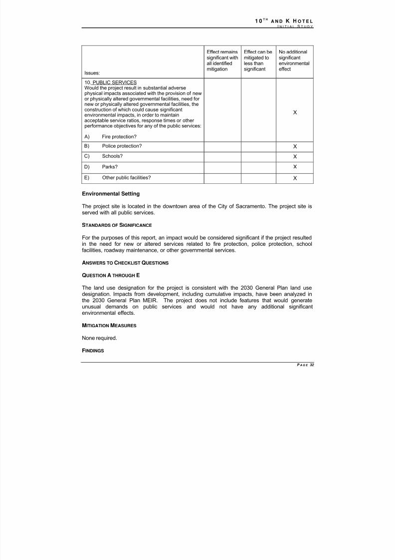
10. PUBLIC SERVICESWould the project result in substantial adversephysical impacts associated with the provision of newor physically altered governmental facilities, need for new or physically altered governmental facilities, theconstruction of which could cause significantenvironmental impacts, in order to maintainacceptable service ratios, response times or other performance objectives for any of the public services:
A) Fire protection?
X
B) Police protection? X
C) Schools? X
D) Parks? X
E) Other public facilities? X
Environmental Setting
The project site is located in the downtown area of the City of Sacramento. The project site isserved with all public services.
STANDARDS OF SIGNIFICANCE
For the purposes of this report, an impact would be considered significant if the project resultedin the need for new or altered services related to fire protection, police protection, schoolfacilities, roadway maintenance, or other governmental services.
ANSWERS TO CHECKLIST QUESTIONS
QUESTION A THROUGH E
The land use designation for the project is consistent with the 2030 General Plan land usedesignation. Impacts from development, including cumulative impacts, have been analyzed in
the 2030 General Plan MEIR. The project does not include features that would generateunusual demands on public services and would not have any additional significantenvironmental effects.
MITIGATION MEASURES
None required.
FINDINGS
8/14/2019 K ST MND 7-1-09
http://slidepdf.com/reader/full/k-st-mnd-7-1-09 34/57
1 0 T HA N D K H O T E L
I N I T I A L S T U D Y
P A G E 33
The project would have no additional significant environmental effects relating to PublicServices.
Issues:
Effect
remainssignificantwith allidentifiedmitigation
Effect can be
mitigated toless thansignificant
No additional
significantenvironmentaleffect
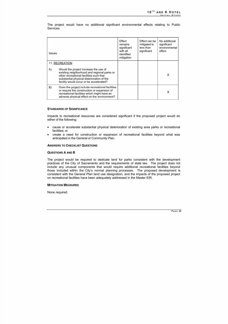
11. RECREATION
A) Would the project increase the use of existing neighborhood and regional parks or other recreational facilities such thatsubstantial physical deterioration of thefacility would occur or be accelerated?
X
B) Does the project include recreational facilitiesor require the construction or expansion of recreational facilities which might have anadverse physical effect on the environment?
X
STANDARDS OF SIGNIFICANCE
Impacts to recreational resources are considered significant if the proposed project would doeither of the following:
• cause or accelerate substantial physical deterioration of existing area parks or recreational
facilities; or • create a need for construction or expansion of recreational facilities beyond what was
anticipated in the General or Community Plan.
ANSWERS TO CHECKLIST QUESTIONS
QUESTIONS A AND B
The project would be required to dedicate land for parks consistent with the developmentpractices of the City of Sacramento and the requirements of state law. The project does notinclude any unusual components that would require additional recreational facilities beyondthose included within the City’s normal planning processes. The proposed development is
consistent with the General Plan land use designation, and the impacts of the proposed projecton recreational facilities have been adequately addressed in the Master EIR.
MITIGATION MEASURES
None required.

8/14/2019 K ST MND 7-1-09
http://slidepdf.com/reader/full/k-st-mnd-7-1-09 35/57
1 0 T HA N D K H O T E L
I N I T I A L S T U D Y
P A G E 34
FINDINGS
The proposed project would have no additional significant environmental effects on recreationalresources.
8/14/2019 K ST MND 7-1-09
http://slidepdf.com/reader/full/k-st-mnd-7-1-09 36/57
1 0 T HA N D K H O T E L
I N I T I A L S T U D Y
P A G E 35
Issues:
Effectremainssignificantwith allidentified
mitigation
Effect can bemitigated toless thansignificant
No additionalsignificantenvironmentaleffect
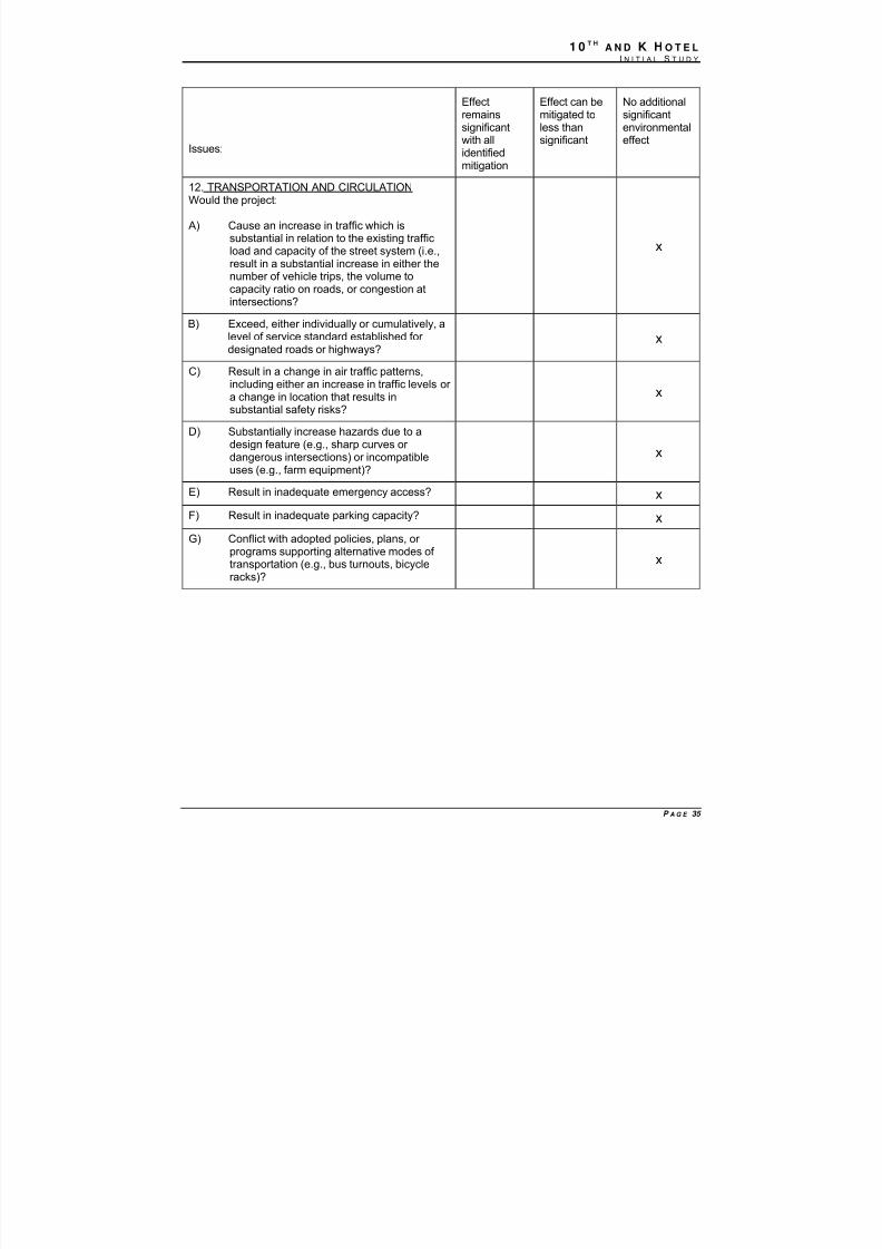
12. TRANSPORTATION AND CIRCULATIONWould the project:
A) Cause an increase in traffic which issubstantial in relation to the existing trafficload and capacity of the street system (i.e.,result in a substantial increase in either thenumber of vehicle trips, the volume tocapacity ratio on roads, or congestion atintersections?
x
B) Exceed, either individually or cumulatively, a
level of service standard established for designated roads or highways?
x
C) Result in a change in air traffic patterns,including either an increase in traffic levels or a change in location that results insubstantial safety risks?
x
D) Substantially increase hazards due to adesign feature (e.g., sharp curves or dangerous intersections) or incompatibleuses (e.g., farm equipment)?
x
E) Result in inadequate emergency access? x
F) Result in inadequate parking capacity? x
G) Conflict with adopted policies, plans, or programs supporting alternative modes of transportation (e.g., bus turnouts, bicycleracks)?
x

8/14/2019 K ST MND 7-1-09
http://slidepdf.com/reader/full/k-st-mnd-7-1-09 37/57
1 0 T HA N D K H O T E L
I N I T I A L S T U D Y
P A G E 36
ENVIRONMENTAL SETTING
The project is located at the southwest corner of the intersection of 10th and K streets in thedowntown area of the Central City. The area consists primarily of commercial, office and retailuses along with government uses. K Street is closed to vehicular traffic, from the Convention Center
at 13th Street. K Street extends six blocks west to the Downtown Plaza. Along the way there are shops, bars,sidewalk cafes, movie theaters and restaurants. 10th Street is a three-lane, one-way, northbound streetthat travels in front of the State Capitol and further to the north passes Cesar Chavez Park andSacramento City Hall where it becomes two way street north of I Street..
REGIONAL ROADWAYS Regional vehicular access to Downtown Sacramento is provided primarily by the freewaysystem that serves the central areas of Sacramento. I-5 is a north-south facility located just westof Downtown. Access from Downtown to I-5 is provided via I, L, P and I streets, and accessfrom I-5 to Downtown is provided via J and Q streets. To the south, I-5 provides accesssouthern portions of the City and County, as well as other Central Valley communities. To thenorth, I-5 provides access to I-80, northern portions of the City and County, SacramentoInternational Airport, and other Central Valley communities.
The east-west US 50 lies approximately 1.5 miles south of Downtown. Access to US 50 fromDowntown is provided via 9th and 15th streets. Access from US 50 to Downtown is provided fromthe 16th and 10th Street off-ramps. To the east, US 50 serves eastern portions of the City andCounty and extends into El Dorado County. To the west, US 50 extends via the Pioneer Bridgeto West Sacramento and Yolo County.
Business 80, also known as State Route 51 between US 50 and Auburn Boulevard, liesapproximately 2 miles east of Downtown. Although access between Downtown and Business 80is available at several locations along the east edge of the Central City, direct access to NorthSacramento, northeastern portions of the City and County, South Natomas via NorthgateBoulevard, and I-80 extending into Placer County.
LOCAL ROADWAYS Downtown Sacramento is served by a grid street system. North-south streets have numberedstreet names and east-west streets have lettered street names. Near Downtown, many streetsoperate as one-way facilities. In general, the one-way streets carry three travel lanes, withparking permitted along both sides of the street. To accommodate critical traffic volumes andturning movements in selected locations, parking has been prohibited to provide additionallanes. Most major intersections in Downtown are signal-controlled.
Important east-west streets for Downtown access include H, J, N, Q, and X streets (which areone-way eastbound) and I, L, P, and W streets (which are one-way westbound except for aportion of N street). Capitol Mall is a two-way east-west facility that extends from the Tower Bridge to the State Capitol at 10th Street. Capitol Mall has two to three lanes in each directionbetween the Tower Bridge and 9 th Street, separated by a grass median. Between 9th and 10th streets, the roadway includes a mid-block traffic circle.
Important north-south streets for Downtown access include 3rd, 7th, 9th, 12th, and 15th streets,which are one-way southbound (except for a portions of 3rd, 7th, and 9th streets) and 5th, 8th, 10th,and 16th streets, which are one-way northbound (except for a portions of 5 th and10th streets).
8/14/2019 K ST MND 7-1-09
http://slidepdf.com/reader/full/k-st-mnd-7-1-09 38/57
1 0 T HA N D K H O T E L
I N I T I A L S T U D Y
P A G E 37
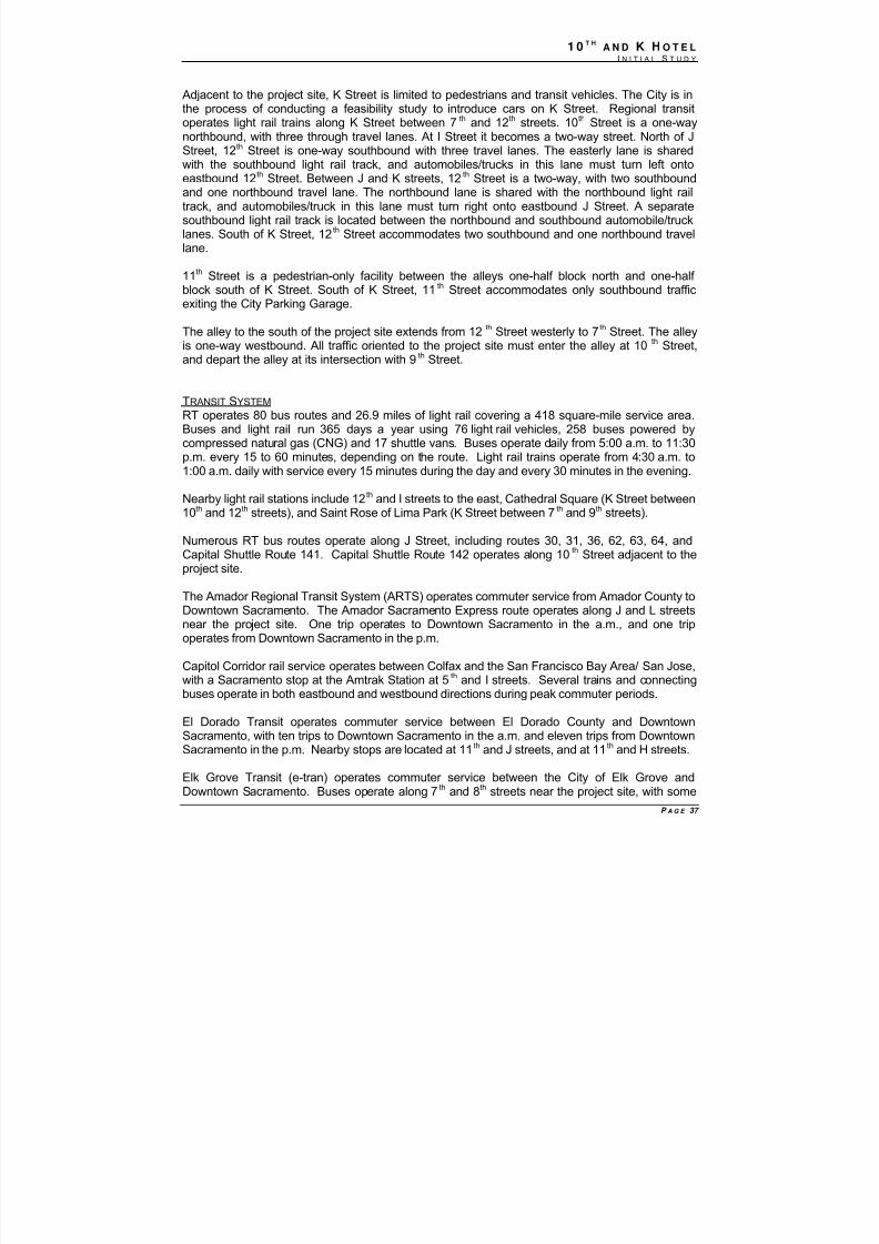
Adjacent to the project site, K Street is limited to pedestrians and transit vehicles. The City is inthe process of conducting a feasibility study to introduce cars on K Street. Regional transitoperates light rail trains along K Street between 7 th and 12th streets. 10th Street is a one-waynorthbound, with three through travel lanes. At I Street it becomes a two-way street. North of JStreet, 12th Street is one-way southbound with three travel lanes. The easterly lane is shared
with the southbound light rail track, and automobiles/trucks in this lane must turn left ontoeastbound 12th Street. Between J and K streets, 12th Street is a two-way, with two southboundand one northbound travel lane. The northbound lane is shared with the northbound light railtrack, and automobiles/truck in this lane must turn right onto eastbound J Street. A separatesouthbound light rail track is located between the northbound and southbound automobile/trucklanes. South of K Street, 12th Street accommodates two southbound and one northbound travellane.
11th Street is a pedestrian-only facility between the alleys one-half block north and one-half block south of K Street. South of K Street, 11th Street accommodates only southbound trafficexiting the City Parking Garage.
The alley to the south of the project site extends from 12
th
Street westerly to 7
th
Street. The alleyis one-way westbound. All traffic oriented to the project site must enter the alley at 10 th Street,and depart the alley at its intersection with 9th Street.
TRANSIT SYSTEM RT operates 80 bus routes and 26.9 miles of light rail covering a 418 square-mile service area.Buses and light rail run 365 days a year using 76 light rail vehicles, 258 buses powered bycompressed natural gas (CNG) and 17 shuttle vans. Buses operate daily from 5:00 a.m. to 11:30p.m. every 15 to 60 minutes, depending on the route. Light rail trains operate from 4:30 a.m. to1:00 a.m. daily with service every 15 minutes during the day and every 30 minutes in the evening.
Nearby light rail stations include 12
th
and I streets to the east, Cathedral Square (K Street between10th and 12th streets), and Saint Rose of Lima Park (K Street between 7th and 9th streets).
Numerous RT bus routes operate along J Street, including routes 30, 31, 36, 62, 63, 64, andCapital Shuttle Route 141. Capital Shuttle Route 142 operates along 10th Street adjacent to theproject site.
The Amador Regional Transit System (ARTS) operates commuter service from Amador County toDowntown Sacramento. The Amador Sacramento Express route operates along J and L streetsnear the project site. One trip operates to Downtown Sacramento in the a.m., and one tripoperates from Downtown Sacramento in the p.m.
Capitol Corridor rail service operates between Colfax and the San Francisco Bay Area/ San Jose,with a Sacramento stop at the Amtrak Station at 5th and I streets. Several trains and connectingbuses operate in both eastbound and westbound directions during peak commuter periods.
El Dorado Transit operates commuter service between El Dorado County and DowntownSacramento, with ten trips to Downtown Sacramento in the a.m. and eleven trips from DowntownSacramento in the p.m. Nearby stops are located at 11th and J streets, and at 11th and H streets.
Elk Grove Transit (e-tran) operates commuter service between the City of Elk Grove andDowntown Sacramento. Buses operate along 7th and 8th streets near the project site, with some
8/14/2019 K ST MND 7-1-09
http://slidepdf.com/reader/full/k-st-mnd-7-1-09 39/57
1 0 T HA N D K H O T E L
I N I T I A L S T U D Y
P A G E 38
service along H and L streets. Seven routes serve Downtown Sacramento.
Placer County Transit operates the Placer County Commuter Express between Placer Countyand Downtown Sacramento. Two inbound trips to Downtown Sacramento operate in the a.m.and two outbound trips from Sacramento operate in the p.m. A nearby stop is located at 11th
and J streets.
The City of Roseville (Roseville Transit) operates seven commuter routes to DowntownSacramento. Nearby stops are located at 12th and I streets, and at 11th and H streets.
The San Joaquin Regional Transit District operates commuter service between Stockton andDowntown Sacramento. Two inbound buses to Downtown Sacramento operate during the a.m.,and two outbound buses from Downtown Sacramento operate during the p.m.
Yolobus operates many bus routes between Yolo County (including West Sacramento, Davis, andWoodland) and Downtown Sacramento. Yolobus also provides service between DowntownSacramento and Sacramento International Airport.
Yuba-Sutter Transit operates commuter service between Yuba and Sutter Counties (includingMarysville and Yuba City) and Downtown Sacramento. Four routes operate in the a.m. toDowntown Sacramento, and four routes operate in the p.m. from Downtown Sacramento.In addition, three midday round trips are provided. A nearby stop is located at 11th andJ streets.
PEDESTRIAN SYSTEM Within the project area, sidewalks are provided on both sides of the majority of City streets.Pedestrian signals are included at most signalized intersections. Many pedestrians are observedin the study area, accessing residences, offices, businesses, and transit services. K Street from7th Street to 12th Street is pedestrian and transit only.
PARKING There are numerous on-street parking along 10th, L, and J streets within the project area.Additionally, the City operates numerous parking garages within the vicinity of the projectincluding lots on I Street between 10 th and 11th (City Hall Garage), between 10th and 11th at LStreet (Capitol Garage)
REGULATORY SETTING
STANDARDS OF SIGNIFICANCE
The standards of significance for Transportation utilize policies in the 2030 General Plan, MobilityElement and, when appropriate, standards used by regulatory agencies. For traffic flow on thefreeway system, the standards of Caltrans have been used.
Roadway SegmentsIn the Central City a significant traffic impact occurs for roadway segments when:
1. The traffic generated by a project degrades peak period Level of Service (LOS) from A,B,C, Dor E (without the project) to F (with project); or
8/14/2019 K ST MND 7-1-09
http://slidepdf.com/reader/full/k-st-mnd-7-1-09 40/57
1 0 T HA N D K H O T E L
I N I T I A L S T U D Y
P A G E 39
2. The LOS (without project) is F, and project generated traffic increases theVolume-to-Capacity Ratio (V/C ratio) by 0.02 or more.
IntersectionsIn the Central City a significant traffic impact occurs for intersections when:
1. The traffic generated by a project degrades peak period level of service from A, B, C , D or E(without project) to F (with project); or
2. The LOS (without project) is F, and project generated traffic increases the peak period averagevehicle delay by five seconds or more.
Freeway FacilitiesCaltrans considers the following to be significant impacts:
• Off-ramps with vehicle queues that extend into the ramp’s deceleration area or onto thefreeway;
•
Project traffic increases that cause any ramp’s merge/diverge level of service to be worsethan the freeway’s level of service;
• Project traffic increases that cause the freeway level of service to deteriorate beyond level of service threshold defined in the Caltrans Route Concept Report for the facility; or
• The expected ramp queue is greater than the storage capacity.
TransitImpacts to the transit system are considered significant if the proposed project would:
• Adversely affect public transit operations or
• Fail to adequately provide for access to public transit.
Bicycle FacilitiesImpacts to bicycle facilities are considered significant if the proposed project would:
• Adversely affect bicycle travel, bicycle paths or
• Fail to adequately provide for access by bicycle.
Pedestrian CirculationImpacts to pedestrian circulation are considered significant if the proposed project would:
• Adversely affect pedestrian travel, pedestrian paths or
• Fail to adequately provide for access by pedestrians.
ParkingImpacts to parking are considered significant if the proposed project would eliminate or adversely affect an existing parking facility, interfere with the implementation of a proposedparking facility, or result in an inadequate supply of parking.
8/14/2019 K ST MND 7-1-09
http://slidepdf.com/reader/full/k-st-mnd-7-1-09 41/57
1 0 T HA N D K H O T E L
I N I T I A L S T U D Y
P A G E 40
ANSWERS TO CHECKLIST QUESTIONS
Question A
The project consists of a 180 room hotel and associated uses located downtown in the urban
core of the Central City. The project is consistent with the recently approved 2030 General Plan.A comparison of the trip generation rates for the typical land uses [Reference: Institute for Transportation Engineers, Trip Generation 8 th Edition] ; indicated that the expected tripgeneration for the proposed project does not exceed the trip generation thresholds thatdemonstrate a need for a traffic study. The total number of additional trips estimated for theproposed project is 867 daily vehicle trips, 60 a.m. peak-hour trips and 74 p.m. peak-hour trips.Furthermore, the project site is in a very close proximity to several transit stations whichsubstantially reduce the vehicular use for the patron of this project.
The total project peak-hour number of trips would not be considered substantial and would notdegrade LOS on roadways or intersections to unacceptable levels. The existing streets in thevicinity of the project site would have adequate capacity to accommodate the project generated
traffic volumes without any significant traffic related impacts. No additional significant effectswould result.
Questions B & D
Pursuant to section 16.48.110 of the City of Sacramento Code, street and roadwayimprovements are designed and constructed to City standards in place at the time that thebuilding permit is issued. All such improvements are designed and constructed to thesatisfaction of the Department of Transportation and this would ensure that there would be nohazards to safety from design features or incompatible uses.
The project shall be required, as a condition of approval, to pay the I-5 corridor impact fee that is
in effect at the time of issuance of building permit and to provide a fair share contribution to theCity’s Traffic Operations Center to monitor and retime the nearby traffic signals when needed.
The proposed project would not result in unsafe conditions for pedestrians; include unsafebicycle/pedestrian or pedestrian/motor vehicle conflicts. The project is located adjacent to 10th Street, which will provide vehicle drop off areas consistent with City design standards. K Streetis closed to vehicular traffic and only pedestrian and transit uses are allowed.
Question C
The project would not result in a change in air traffic patterns. The project consists of a twelvestory hotel in the downtown area of the Central City. There are numerous buildings within the
vicinity of the project site that are taller than twelve stories. No additional significant effectswould result.
Question E
Existing road infrastructure provides adequate emergency access to the project site. The projectis required to be designed to appropriate standards, to the satisfaction of the City of Sacramento, Department of Transportation, Traffic Engineering Division and Fire Department.No additional significant effects relating to emergency access would occur.
8/14/2019 K ST MND 7-1-09
http://slidepdf.com/reader/full/k-st-mnd-7-1-09 42/57
1 0 T HA N D K H O T E L
I N I T I A L S T U D Y
P A G E 41
Question F
The project review process would include a review of the applicant’s proposals for parking, andexamination of alternative means of meeting City requirements. Recent projects in thedowntown area have used various means of satisfying parking demand, including valet parking,and use of nearby parking facilities on a shared basis. No additional significant environmental
effect would occur.
Question G
The project would not conflict with alternative modes of transportation. The project would beconstructing a hotel within the downtown urban core of the Central City. The project is locatedadjacent to existing light rail and bus transit stops. The project would construct and operate ahotel that would increase residential uses in the downtown area, and would tend to increase theuse of alternative modes of transportation. No additional effects would result.
MITIGATION MEASURES
None required.
FINDINGS
The project would have no additional project-specific environmental effects relating toTransportation and Circulation.
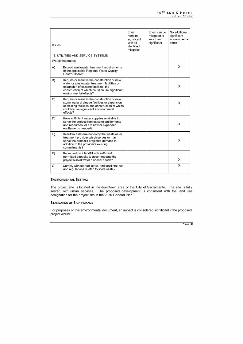
8/14/2019 K ST MND 7-1-09
http://slidepdf.com/reader/full/k-st-mnd-7-1-09 43/57
1 0 T HA N D K H O T E L
I N I T I A L S T U D Y
P A G E 42
Issues:
Effectremainssignificantwith all
identifiedmitigation
Effect can bemitigated toless thansignificant
No additionalsignificantenvironmentaleffect
13. UTILITIES AND SERVICE SYSTEMS
Would the project:
A) Exceed wastewater treatment requirementsof the applicable Regional Water QualityControl Board?
X
B) Require or result in the construction of newwater or wastewater treatment facilities or expansion of existing facilities, theconstruction of which could cause significant
environmental effects?
X
C) Require or result in the construction of newstorm water drainage facilities or expansionof existing facilities, the construction of whichcould cause significant environmentaleffects?
X
D) Have sufficient water supplies available toserve the project from existing entitlementsand resources, or are new or expandedentitlements needed?
X
E) Result in a determination by the wastewater treatment provider which serves or mayserve the project’s projected demand inaddition to the provider’s existingcommitments?
X
F) Be served by a landfill with sufficientpermitted capacity to accommodate theproject’s solid water disposal needs? X
G) Comply with federal, state, and local statutesand regulations related to solid waste?
X
ENVIRONMENTAL SETTING
The project site is located in the downtown area of the City of Sacramento. The site is fullyserved with urban services. The proposed development is consistent with the land usedesignation for the project site in the 2030 General Plan.
STANDARDS OF SIGNIFICANCE
For purposes of this environmental document, an impact is considered significant if the proposedproject would:
8/14/2019 K ST MND 7-1-09
http://slidepdf.com/reader/full/k-st-mnd-7-1-09 44/57
1 0 T HA N D K H O T E L
I N I T I A L S T U D Y
P A G E 43
• Result in a detriment to microwave, radar, or radio transmissions;
• Create an increase in water demand of more than 10 million gallons per day;
• Substantially degrade water quality;
• Generate more than 500 tons of solid waste per year; or
• Generate stormwater that would exceed the capacity of the stormwater system.
ANSWERS TO CHECKLIST QUESTIONS
QUESTION A THROUGH G
The proposed project is consistent with 2030 General Plan land use designation for the projectsite. The Master EIR prepared for the 2030 General Plan evaluated the impacts of developmentas proposed under the 2030 General Plan. The proposed project includes no components thatwould generate environmental effects that were not considered in the Master EIR.
MITIGATION MEASURES
None required.
FINDINGS
The project would have no additional significant environmental effects relating to Utilities andService Systems.
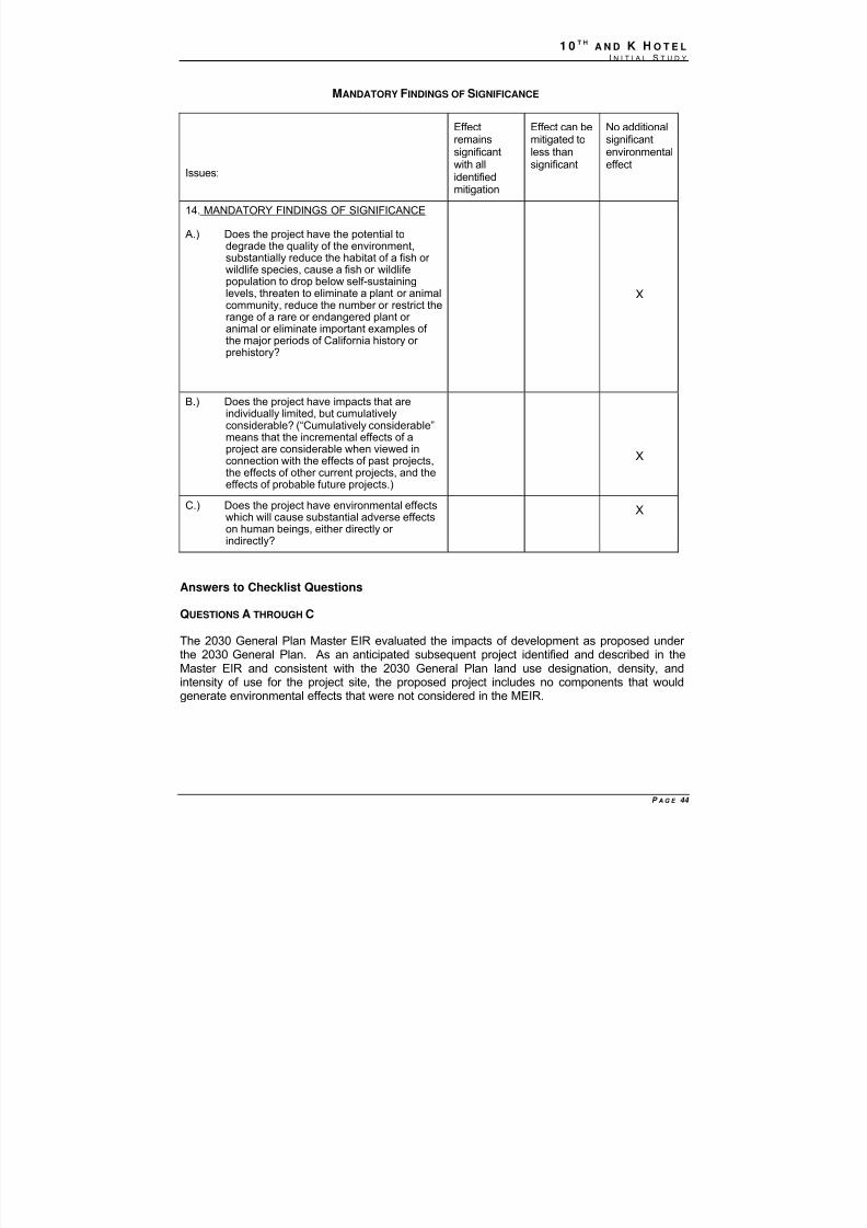
8/14/2019 K ST MND 7-1-09
http://slidepdf.com/reader/full/k-st-mnd-7-1-09 45/57
1 0 T HA N D K H O T E L
I N I T I A L S T U D Y
P A G E 44
MANDATORY FINDINGS OF SIGNIFICANCE
Issues:
Effectremainssignificant
with allidentifiedmitigation
Effect can bemitigated toless than
significant
No additionalsignificantenvironmental
effect
14. MANDATORY FINDINGS OF SIGNIFICANCE
A.) Does the project have the potential todegrade the quality of the environment,substantially reduce the habitat of a fish or wildlife species, cause a fish or wildlifepopulation to drop below self-sustaininglevels, threaten to eliminate a plant or animalcommunity, reduce the number or restrict therange of a rare or endangered plant or
animal or eliminate important examples of the major periods of California history or prehistory?
X
B.) Does the project have impacts that areindividually limited, but cumulativelyconsiderable? (“Cumulatively considerable”means that the incremental effects of aproject are considerable when viewed inconnection with the effects of past projects,the effects of other current projects, and theeffects of probable future projects.)
X
C.) Does the project have environmental effectswhich will cause substantial adverse effectson human beings, either directly or indirectly?
X
Answers to Checklist Questions
QUESTIONS A THROUGH C
The 2030 General Plan Master EIR evaluated the impacts of development as proposed under the 2030 General Plan. As an anticipated subsequent project identified and described in the
Master EIR and consistent with the 2030 General Plan land use designation, density, andintensity of use for the project site, the proposed project includes no components that wouldgenerate environmental effects that were not considered in the MEIR.
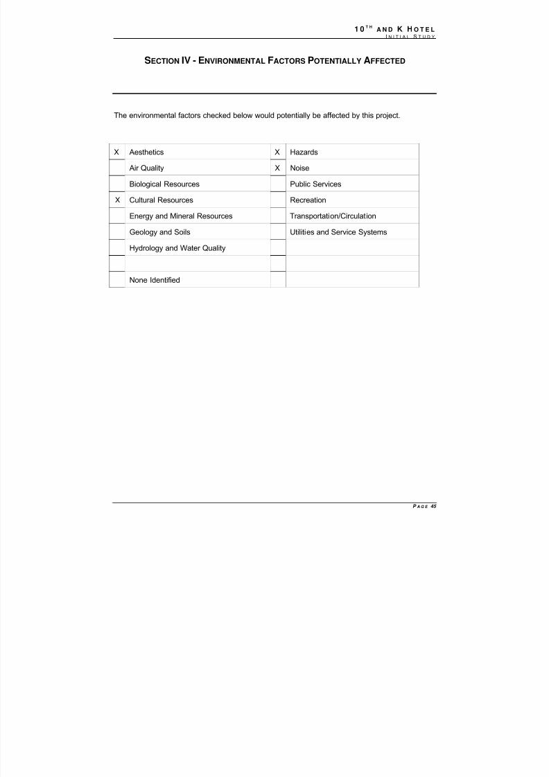
8/14/2019 K ST MND 7-1-09
http://slidepdf.com/reader/full/k-st-mnd-7-1-09 46/57
1 0 T HA N D K H O T E L
I N I T I A L S T U D Y
P A G E 45
SECTION IV - ENVIRONMENTAL FACTORS POTENTIALLY AFFECTED
The environmental factors checked below would potentially be affected by this project.
X Aesthetics X Hazards
Air Quality X Noise
Biological Resources Public Services
X Cultural Resources Recreation
Energy and Mineral Resources Transportation/Circulation
Geology and Soils Utilities and Service Systems
Hydrology and Water Quality
None Identified
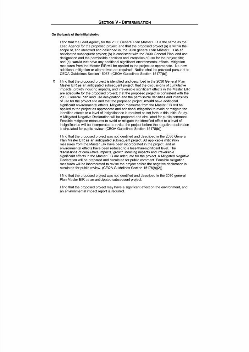
8/14/2019 K ST MND 7-1-09
http://slidepdf.com/reader/full/k-st-mnd-7-1-09 47/57
SECTION V - DETERMINATION
On the basis of the initial study:
I find that the Lead Agency for the 2030 General Plan Master EIR is the same as the
Lead Agency for the proposed project, and that the proposed project (a) is within thescope of, and identified and described in, the 2030 general Plan Master EIR as ananticipated subsequent project; (b) is consistent with the 2030 General Plan land usedesignation and the permissible densities and intensities of use for the project site;and (c), would not have any additional significant environmental effects. Mitigationmeasures from the Master EIR will be applied to the project as appropriate. No newadditional mitigation or alternatives are required. Notice shall be provided pursuant toCEQA Guidelines Section 15087. (CEQA Guidelines Section 15177(b))
X I find that the proposed project is identified and described in the 2030 General PlanMaster EIR as an anticipated subsequent project; that the discussions of cumulativeimpacts, growth inducing impacts, and irreversible significant effects in the Master EIRare adequate for the proposed project; that the proposed project is consistent with the2030 General Plan land use designation and the permissible densities and intensitiesof use for the project site and that the proposed project would have additionalsignificant environmental effects. Mitigation measures from the Master EIR will beapplied to the project as appropriate and additional mitigation to avoid or mitigate theidentified effects to a level of insignificance is required as set forth in this Initial Study.A Mitigated Negative Declaration will be prepared and circulated for public comment.Feasible mitigation measures to avoid or mitigate the identified effect to a level of insignificance will be incorporated to revise the project before the negative declarationis circulated for public review. (CEQA Guidelines Section 15178(b))
I find that the proposed project was not identified and described in the 2030 GeneralPlan Master EIR as an anticipated subsequent project. All applicable mitigationmeasures from the Master EIR have been incorporated in the project, and allenvironmental effects have been reduced to a less-than-significant level. Thediscussions of cumulative impacts, growth inducing impacts and irreversiblesignificant effects in the Master EIR are adequate for the project. A Mitigated NegativeDeclaration will be prepared and circulated for public comment. Feasible mitigationmeasures will be incorporated to revise the project before the negative declaration iscirculated for public review. (CEQA Guidelines Section 15178(b)(2))
I find that the proposed project was not identified and described in the 2030 generalPlan Master EIR as an anticipated subsequent project.
I find that the proposed project may have a significant effect on the environment, and
an environmental impact report is required.

8/14/2019 K ST MND 7-1-09
http://slidepdf.com/reader/full/k-st-mnd-7-1-09 48/57
8/14/2019 K ST MND 7-1-09
http://slidepdf.com/reader/full/k-st-mnd-7-1-09 49/57
REFERENCES CITED
Air Resources Board, GHG Emission Inventory Summary (1990-2004)http://www.arb.ca.gov/app/ghg/ghg_sector_data_php
CARB. 2009. California Greenhouse Gas Inventory for 2000-2006 - by Category as Defined in the Scoping Plan. [Online.] Accessed June 24, 2009 online:http://www.arb.ca.gov/cc/inventory/data/tables/ghg_inventory_scopingplan_2009-03-13.pdf
City of Sacramento. 2009 2030 General Plan .
City of Sacramento. 2008. Sacramento 2030 General Plan Master Environmental Impact Report
City of Sacramento, Department of Utilities. 2007. Table 3-2 Stormwater Quality Control Measure Selection Matrix in the Stormwater Quality Design Manual.
Institute for Transportation Engineers, Trip Generation 7th Edition
Sacramento Metropolitan Air Quality Management District (SMAQMD) 2004. Guide to Air Quality Assessment in Sacramento County.
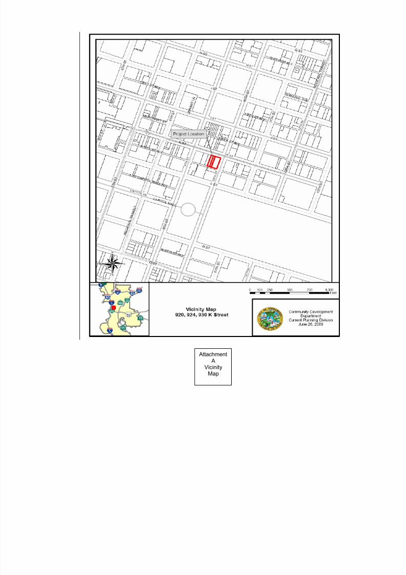
8/14/2019 K ST MND 7-1-09
http://slidepdf.com/reader/full/k-st-mnd-7-1-09 50/57
AttachmentA
VicinityMap
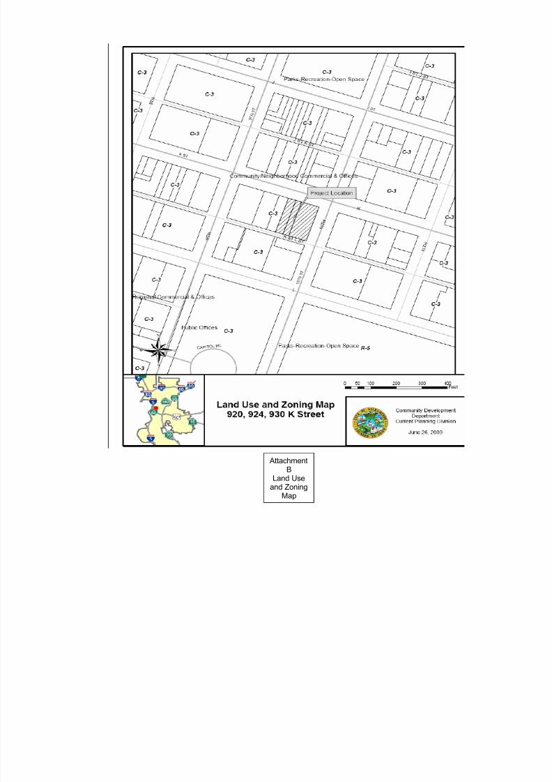
8/14/2019 K ST MND 7-1-09
http://slidepdf.com/reader/full/k-st-mnd-7-1-09 51/57
AttachmentB
Land Useand Zoning
Map
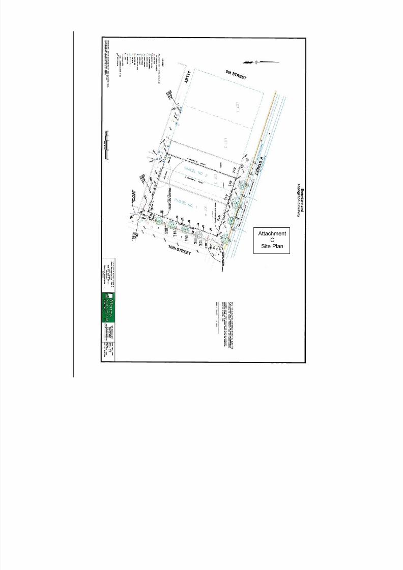
8/14/2019 K ST MND 7-1-09
http://slidepdf.com/reader/full/k-st-mnd-7-1-09 52/57
AttachmentC
Site Plan
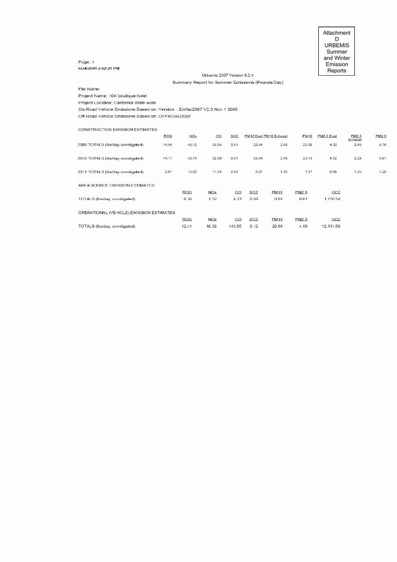
8/14/2019 K ST MND 7-1-09
http://slidepdf.com/reader/full/k-st-mnd-7-1-09 53/57
Atta
URSu
andEmRe

8/14/2019 K ST MND 7-1-09
http://slidepdf.com/reader/full/k-st-mnd-7-1-09 54/57
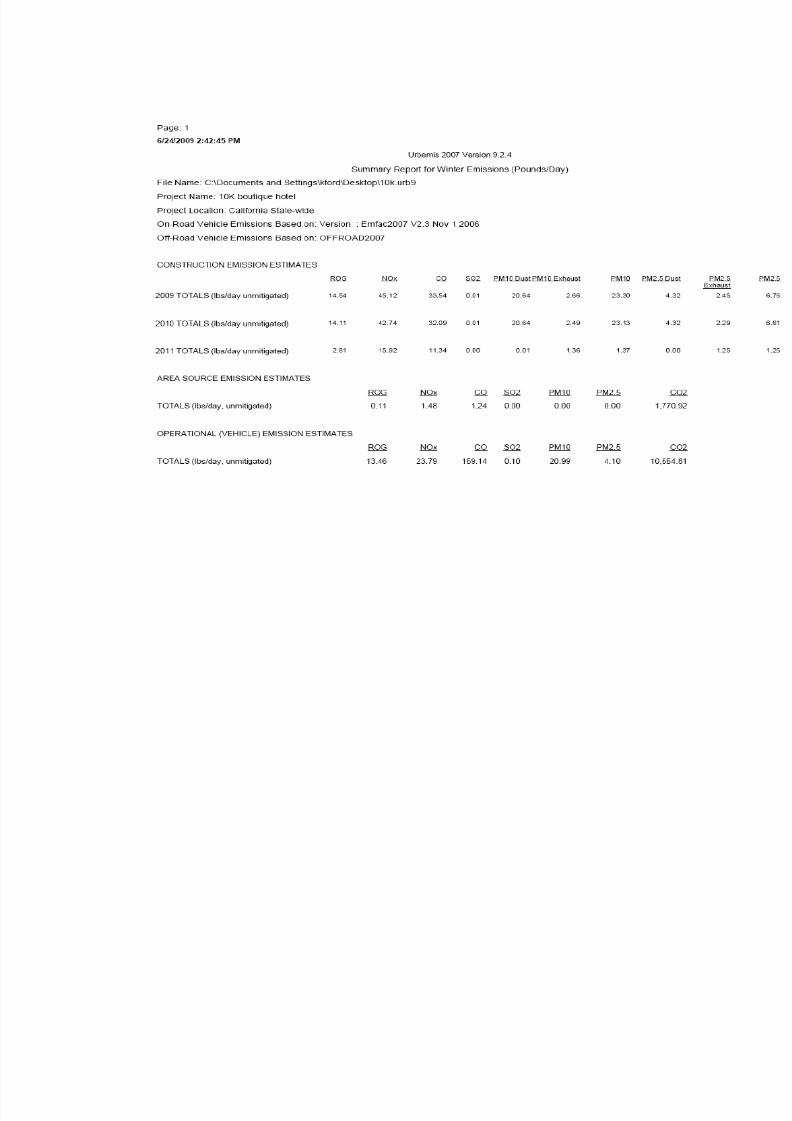
8/14/2019 K ST MND 7-1-09
http://slidepdf.com/reader/full/k-st-mnd-7-1-09 55/57

8/14/2019 K ST MND 7-1-09
http://slidepdf.com/reader/full/k-st-mnd-7-1-09 56/57

8/14/2019 K ST MND 7-1-09
http://slidepdf.com/reader/full/k-st-mnd-7-1-09 57/57