GEODETIC REFERENCE SYSTEM 1980cmantunes/... · GEODETIC REFERENCE SYSTEM 1980 by H. Moritz...
35
GEODETIC REFERENCE SYSTEM 1980 by H. Moritz Corrigendum: Due to some unfortunate error this article appeared wrongly in The Geodesists Handbook 1992 (Bulletin Geodesique, 66, 2, 1992). Among several errors a h (polar distance) was interchanged with a F (geographi- cal latitude) aecting the formulas for normal gravity. It is advised that you use the formulas here or in the Geodesists handbook from Bulletin Geodesique, Vol. 62, no. 3, 1988. 1- Definition The Geodetic Reference System 1980 has been adopted at the XVII General Assembly of the IUGG in Canberra, December 1979, by means of the following: ‘‘RESOLUTION N° 7 The International Union of Geodesy and Geophysics recognizing that the Geodetic Reference System 1967 adopted at the XIV General Assembly of IUGG, Lu- cerne, 1967, no longer represents the size, shape, and gravity field of the Earth to an accuracy adequate for many geodetic, geophysical, astronomical and hydro- graphic applications and considering that more appropriate values are now available, recommends a) that the Geodetic Reference System 1967 be re- placed by a new Geodetic Reference System 1980, also based on the theory of the geocentric equipotential el- lipsoid, defined by the following conventional constants: • equatorial radius of the Earth: a = 6378 137 m, • geocentric gravitational constant of the Earth (including the atmosphere): GM = 3986 005 · 10 8 m 3 s )2 , • dynamical form factor of the Earth, excluding the permanent tidal deformation: J 2 = 108 263 · 10 )8 , • angular velocity of the Earth: x = 7292 115 · 10 )11 rad s )1 , b) that the same computational formulas, adopted at the XV General Assembly of IUGG in Moscow 1971 and published by IAG, be used as for Geodetic Refer- ence System 1967, and c) that the minor axis of the reference ellipsoid, de- fined above, be parallel to the direction defined by the Conventional International Origin, and that the primary meridian be parallel to the zero meridian of the BIH adopted longitudes’’. For the background of this resolution see the report of IAG Special Study Group 5.39 (Moritz, 1979, sec.2).c Also relevant is the following IAG resolution: ‘‘RESOLUTION N° 1 The International Association of Geodesy recognizing that the IUGG, at its XVII General As- sembly, has introduced a new Geodetic Reference Sys- tem 1980, recommends that this system be used as an ocial reference for geodetic work, and encourages computations of the gravity field both on the Earth’s surface and in outer space based on this system’’. 2- The Equipotential Ellipsoid According to the first resolution, the Geodetic Refer- ence System 1980 is based on the theory of the equipo- 128
Transcript of GEODETIC REFERENCE SYSTEM 1980cmantunes/... · GEODETIC REFERENCE SYSTEM 1980 by H. Moritz...
GEODETIC REFERENCE SYSTEM 1980
by H. Moritz
Corrigendum:
Due to some unfortunate error this article appearedwrongly in The Geodesists Handbook 1992 (BulletinGeodesique, 66, 2, 1992). Among several errors a h(polar distance) was interchanged with a F (geographi-cal latitude) a�ecting the formulas for normal gravity. Itis advised that you use the formulas here or in theGeodesists handbook from Bulletin Geodesique, Vol.62, no. 3, 1988.
1- De®nition
The Geodetic Reference System 1980 has beenadopted at the XVII General Assembly of the IUGG inCanberra, December 1979, by means of the following:
``RESOLUTION N° 7
The International Union of Geodesy and Geophysics
recognizing that the Geodetic Reference System 1967adopted at the XIV General Assembly of IUGG, Lu-cerne, 1967, no longer represents the size, shape, andgravity ®eld of the Earth to an accuracy adequate formany geodetic, geophysical, astronomical and hydro-graphic applications and
considering that more appropriate values are nowavailable,
recommends
a) that the Geodetic Reference System 1967 be re-placed by a new Geodetic Reference System 1980, alsobased on the theory of the geocentric equipotential el-lipsoid, de®ned by the following conventional constants:
· equatorial radius of the Earth:
a = 6378 137 m,
· geocentric gravitational constant of the Earth(including the atmosphere):
GM = 3986 005 ´ 108 m3 s)2,
· dynamical form factor of the Earth, excluding thepermanent tidal deformation:
J2 = 108 263 ´ 10)8,
· angular velocity of the Earth:
x = 7292 115 ´ 10)11 rad s)1,
b) that the same computational formulas, adopted atthe XV General Assembly of IUGG in Moscow 1971and published by IAG, be used as for Geodetic Refer-ence System 1967, and
c) that the minor axis of the reference ellipsoid, de-®ned above, be parallel to the direction de®ned by theConventional International Origin, and that the primarymeridian be parallel to the zero meridian of the BIHadopted longitudes''.
For the background of this resolution see the reportof IAG Special Study Group 5.39 (Moritz, 1979, sec.2).c
Also relevant is the following IAG resolution:
``RESOLUTION N° 1
The International Association of Geodesy
recognizing that the IUGG, at its XVII General As-sembly, has introduced a new Geodetic Reference Sys-tem 1980,
recommends that this system be used as an o�cialreference for geodetic work, and
encourages computations of the gravity ®eld both onthe Earth's surface and in outer space based on thissystem''.
2- The Equipotential Ellipsoid
According to the ®rst resolution, the Geodetic Refer-ence System 1980 is based on the theory of the equipo-
128
tential ellipsoid. This theory has already been the basis ofthe Geodetic Reference System 1967; we shall summarize(partly quoting literally) some principal facts from therelevant publication (IAG, 1971, Publ. Spe c. n° 3).
An equipotential ellipsoid or level ellipsoid is an el-lipsoid that is de®ned to be an equipotential surface. If anellipsoid of revolution (semimajor axis a, semiminor axisb) is given, then it can be made an equipotential surface
U � U0 � const:
of a certain potential function U, called normal poten-tial. This function U is uniquely determined by means ofthe ellipsoidal surface (semiaxes a, b), the enclosed massM and the angular velocity x, according to a theorem ofStokes-Poincare , quite independently of the internaldensity distribution. Instead of the four constants a, b,M and x, any other system of four independent pa-rameters may be used as de®ning constants.
The theory of the equipotential ellipsoid was ®rstgiven by Pizzeti in 1894; it was further elaborated bySomigliana in 1929. This theory had already served as abase for the International Gravity Formula adopted atthe General Assembly in Stockholm in 1930.
Normal gravity c � jgrad Uj at the surface of theellipsoid is given by the closed formula of Somilgiana,
c � ace cos2 U� bcp sin
2 U������������������������������������������a2 cos2 U� b2 sin2 U
p ;
where the constants ce and cp denote normal gravity atthe equator and at the poles, and F denotes geograph-ical latitude.
The equipotential ellipsoid furnishes a simple, con-sistent and uniform reference system for all purposes ofgeodesy: the ellipsoid as a reference surface for geo-metric use, and a normal gravity ®eld at the earth'ssurface and in space, de®ned in terms of closed formulas,as a reference for gravimetry and satellite geodesy.
The standard theory of the equipotential ellipsoidregards the normal gravitational potential as a harmonicfunction outside the ellipsoid, which implies the absenceof an atmosphere. (The consideration of the atmospherein the reference system would require an ad-hoc modi-®cation of the theory, whereby it would lose its clarityand simplicity.)
Thus, in the same way as in the Geodetic ReferenceSystem 1967, the computation are based on the theory ofthe equipotential ellipsoid without an atmosphere. Thereference ellipsoid is de®ned to enclose the whole massof the earth, including the atmosphere; as a visualiza-tion, one might, for instance, imagine the atmosphere tobe condensed as a surface layer on the ellipsoid. Thenormal gravity ®eld at the earth's surface and in spacecan thus be computed without any need for consideringthe variation of atmospheric density.
If atmospheric e�ects must be considered, this can bedone by applying corrections to the measured values ofgravity; for this purpose, a table of corrections will begiven later (sec.5).
3- Computational Formulas
An equipotential ellipsoid of revolution is determinedby four constants. The IUGG has chosen the followingones:
a equatorial radius,GM geocentric gravitational constant,J2 dynamical form factor,x angular velocity.
The equatorial radius a is the semimajor axis of themeridian ellipse; the semiminor axis will be denoted byb. The geocentric gravitational constant GM is theproduct of the Newtonian gravitational constant, G, andthe total mass of the earth, M. The constant J2 is givenby:
J2 � CÿA
Ma2;
where C and A are the principal moments of inertia ofthe level ellipsoid (C... polar, A... equatorial moment ofinertia).
We shall also use the ®rst excentricity e, de®ned by:
e2 � a2 ÿ b2
a2;
and the second excentricity e¢, de®ned by:
e02 � a2 ÿ b2
b2
Closed computational formulas are given in sec.3 of(IAG, 1971, Pub.Spe c. n° 3); we shall here reproducethis section practically unchanged.
The derivation of these formulas is found in the book(Heiskanen and Moritz, 1967) sections 2±7 to 2±10.Reference to this book is by page number and number ofequation.
Computation of e2
The fundamental derived constant is the square of the®rst excentricity, e2, as de®ned above.
From p. 73, equations (2-90) and (2-92¢), we ®nd:
J2 � e2
31ÿ 2
15
me0
qo
� �This equation can be written as:
e2 � 3J2 � 2me0e2
15q0
129
with:
m � x2a2b
GM
(p. 69, eq. (2-70)) and with be¢ = ae it becomes:
e2 � 3J2 � 4
15
x2a3
GM
a3
2q0
This is the basic equation which relates e2 to thedata a, GM, J2 and x. It is to be solved iteratively for e2,taking into account:
2q0 � 1� 3
e02
� �arctan e0 ÿ 3
e0
�X1n�1
4�ÿ1�n�1n�2n� 1��2n� 3� e
02n�1
with
e0 � e�������������1ÿ e2p �second excentricity�
(p. 66, eq. (2-58), p. 72, second equation from top).
Geometric Constants
Now the other geometric constants of the referenceellipsoid can be computed by the well-known formulas:
b � a�������������1ÿ e2p
�semiminor axis�;f � aÿ b
a�flattening�;
E ����������������a2 ÿ b2
p�linear excentricity�;
c � a2
b�polar radius of curvature�:
The arc of meridian from equator to pole (meridianquadrant) is given by:
Q � c
Z p=2
0
dU
�1� e02 cos2 U�3=2
where F is the geographical latitude. This integral can beevaluated by a series expansion:
Q � cp2
1ÿ 3
4e02 � 45
64e04 ÿ 175
256e06 � 11025
16384e08
� �Various mean radii of ellipsoid are de®ned by the
following formulas:
arithmetic mean:
R1 � a� a� b
3� a 1ÿ f
3
� �radius of sphere of the same surface:
R2 � c
Z p=2
0
cosU
�1� e02 cos2 U�2 dU
!1=2
� c 1ÿ 2
3e02 � 26
45e04 ÿ 100
189e06 � 7034
14175e08
� �radius of sphere of the same volume:
R3 ��������a2b
3p
:
Physical Constants
The reference ellipsoid is a surface of constant normalpotential, U = U0. This constant U0, the normal po-tential of the reference ellipsoid, is given by:
U0 � GM
Earctan e0 � 1
3x2a2
� GM
b1�
X1n�1�ÿ1�n e02n
2n� 1� 1
3m
!
(p. 67, eq. (2-61)).
The normal gravitational potential V (gravity po-tential U minus potential of centrifugal force) can bedeveloped into a series of zonal spherical harmonics:
V � GM
r1ÿ
X1n�1
J2na
r
� �2nP2n�cos h�
!;
where r (radius vector) and h (polar distance) arespherical coordinates. The coe�cient J2 is a de®ningconstant; the other coe�cients are expressed in terms ofJ2 by:
J2n � �ÿ1�n�1 3e2n
�2n� 1��2n� 3� 1ÿ n� 5nJ2e2
� �(p.73, eqs. (2-92) and (2-92¢)).
Normal gravity at the equator, ce, and normal gravityat the poles, cp, are given by the expressions:
ce �GM
ab1ÿmÿm
6
e0q00q0
� �cp �
GM
a21�m
3
e0q00q0
� �with
q00 � 3 1� 1
e02
� �1ÿ 1
e0arctan e0
� �ÿ 1
and
m � x2a2b
GM
(p. 69, eqs. (2-73) and (2-74); p.68, eq. (2-67)).
130
The constant:
f� � cp ÿ cece
�gravity flattening�
is also needed.
A check is provided by the closed form of Clairaut'stheorem for the equipotential ellipsoid:
f� f� � x2b
ce1� e0q00
2q0
� �(p. 69, eq. (2-75)).
The Gravity Formula
Somiglinana's closed formula for normal gravity is
c � ace cos2 U� bcp sin
2 U������������������������������������������a2 cos2 U� b2 sin2 U
pFor numerical computations, the form
c � ce1� k sin2 U��������������������������1ÿ e2 sin2 U
pwith
k � bcpaceÿ 1
is more convenient.
The conventional abbreviated series expansion is:
c � ce�1� f� sin2 Uÿ 1
4f4 sin
2 2U�
with
f4 � 1
2f2 � 5
2fm
(p.77, eqs. (2-115) and (2-116)).
More generally, the above closed formula for normalgravity may be expanded into the series
c � ce 1�X1n�1
a2n sin2n U
!
where
a2 � 1
2e2 � k; a6 � 5
16e6 � 3
8e4k;
a4 � 3
8e4 � 1
2e2k; a8 � 35
128e8 � 5
16e6k;
The average value of gravity over the ellipsoid is
�c �Z p=2
0
c cosUdU
�1ÿ e2 sin2 U�2 :
Z p=2
0
cosUdU
�1ÿ e2 sin2 U�2
� 1� 1
6e2 � 1
3k� 59
360e4 � 5
18e2k
� 2371
15120e6 � 259
1080e4k� 270229
1814400e8 � 9623
45360e6k:
4- Numerical Values
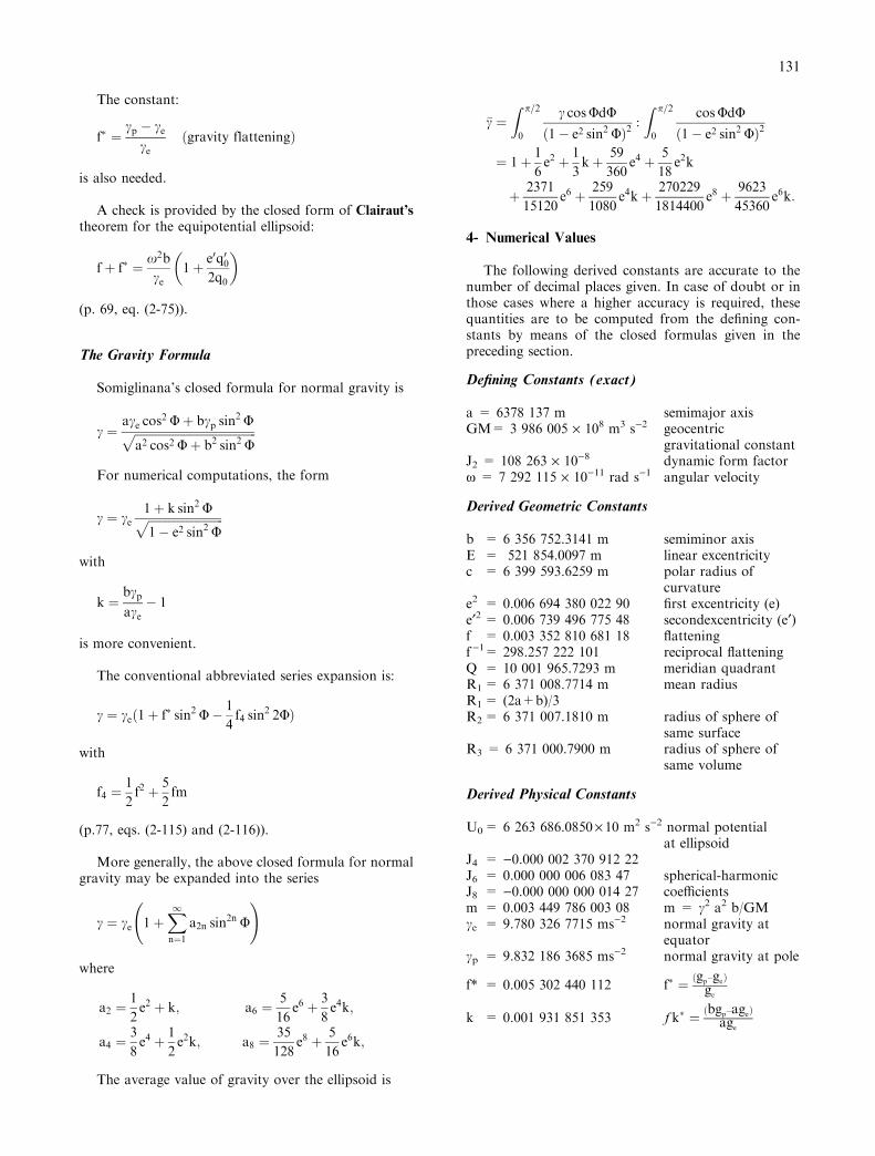
The following derived constants are accurate to thenumber of decimal places given. In case of doubt or inthose cases where a higher accuracy is required, thesequantities are to be computed from the de®ning con-stants by means of the closed formulas given in thepreceding section.
De®ning Constants (exact)
a = 6378 137 m semimajor axisGM= 3 986 005 ´ 108 m3 s)2 geocentric
gravitational constantJ2 = 108 263 ´ 10)8 dynamic form factorx = 7 292 115 ´ 10)11 rad s)1 angular velocity
Derived Geometric Constants
b = 6 356 752.3141 m semiminor axisE = 521 854.0097 m linear excentricityc = 6 399 593.6259 m polar radius of
curvaturee2 = 0.006 694 380 022 90 ®rst excentricity (e)e¢2 = 0.006 739 496 775 48 secondexcentricity (e¢)f = 0.003 352 810 681 18 ¯atteningf)1= 298.257 222 101 reciprocal ¯atteningQ = 10 001 965.7293 m meridian quadrantR1= 6 371 008.7714 m mean radiusR1= (2a+b)/3R2= 6 371 007.1810 m radius of sphere of
same surfaceR3 = 6 371 000.7900 m radius of sphere of
same volume
Derived Physical Constants
U0= 6 263 686.0850´ 10 m2 s)2 normal potentialat ellipsoid
J4 = )0.000 002 370 912 22J6 = 0.000 000 006 083 47 spherical-harmonicJ8 = )0.000 000 000 014 27 coe�cientsm = 0.003 449 786 003 08 m = c2 a2 b/GMce = 9.780 326 7715 ms)2 normal gravity at
equatorcp = 9.832 186 3685 ms)2 normal gravity at pole
f* = 0.005 302 440 112 f� � �gp±ge�ge
k = 0.001 931 851 353 fk� � �bgp±age�age
131
Gravity Formula 1980
Normal gravity may be computed by means of theclosed formula:
c � ce1� k sin2 U��������������������������1ÿ e2 sin2 U
p ;
with the values of ce, k, and e2 shown above.
The series expansion, given at the end of sec. 3, be-comes:
c � ce�1� 0:005 279 0414 sin2 U
� 0:000 023 2718 sin4 U
� 0:000 000 1262 sin6 U
� 0:000 000 0007 sin8 U�;
it has a relative error of 10)10, correspondingto 10)3 lm s)2 = 10)4 mgal.
The conventional series
c � ce�1� f� sin2 Uÿ 1
4f4 sin
2 2U�� 9:780 327�1� 0:005 3024 sin2 U
ÿ 0:000 0058 sin2 2U�msÿ2
has only an accuracy of 1 lm s)2 = 0.1 mgal. It can,however, be used for converting gravity anomalies fromthe International Gravity Formula (1930) to the GravityFormula 1980:
c1980 ÿ c1930 � �ÿ16:3� 13:7 sin2 U�mgal;
where the main part comes from a change of thePostdam reference value by ± 14 mgal; see also (IAG,1971, Publ. Spe c. n° 3, p.74).
For the conversion from the Gravity Formula 1967to the Gravity Formula 1980, a more accurate formula,corresponding to the precise expansion given above, is:
c1980 ÿ c1967 � �0:8316� 0:0782 sin2 U
ÿ 0:0007 sin4 U�mgal;
Since former gravity values are expressed in the units``gal'' and ``mgal'', we have, in the conversion formulas,used the unit 1 mgal = 10)5 m s)2.
Mean values of normal gravity are:
�c � 9:797 644 656 m s)2 average over ellipsoid,
c45= 9.806 199 203 m s)2 c
at latitude F = 45°.
The numerical values given in this section have beencomputed independently by Mr. Chung-Yung Chen,
using series developments up to f5, and by Dr. Hans-SuÈ nkel, using the formulas presented in sec. 3.
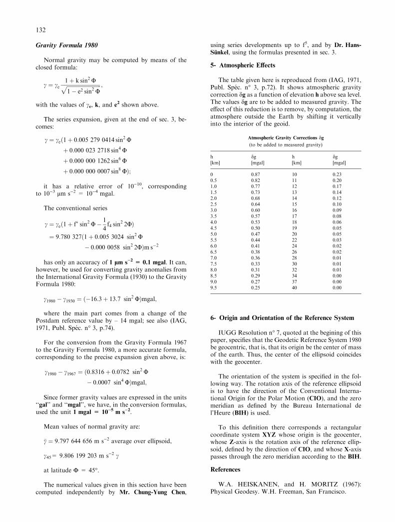
5- Atmospheric E�ects
The table given here is reproduced from (IAG, 1971,Publ. Spe c. n° 3, p.72). It shows atmospheric gravitycorrection dg as a function of elevation h above sea level.The values dg are to be added to measured gravity. Thee�ect of this reduction is to remove, by computation, theatmosphere outside the Earth by shifting it verticallyinto the interior of the geoid.
Atmospheric Gravity Corrections dg
(to be added to measured gravity)
h dg h dg[km] [mgal] [km] [mgal]
0 0.87 10 0.230.5 0.82 11 0.201.0 0.77 12 0.171.5 0.73 13 0.142.0 0.68 14 0.122.5 0.64 15 0.103.0 0.60 16 0.093.5 0.57 17 0.084.0 0.53 18 0.064.5 0.50 19 0.055.0 0.47 20 0.055.5 0.44 22 0.036.0 0.41 24 0.026.5 0.38 26 0.027.0 0.36 28 0.017.5 0.33 30 0.018.0 0.31 32 0.018.5 0.29 34 0.009.0 0.27 37 0.009.5 0.25 40 0.00
6- Origin and Orientation of the Reference System
IUGG Resolution n° 7, quoted at the begining of thispaper, speci®es that the Geodetic Reference System 1980be geocentric, that is, that its origin be the center of massof the earth. Thus, the center of the ellipsoid coincideswith the geocenter.
The orientation of the system is speci®ed in the fol-lowing way. The rotation axis of the reference ellipsoidis to have the direction of the Conventional Interna-tional Origin for the Polar Motion (CIO), and the zeromeridian as de®ned by the Bureau International del'Heure (BIH) is used.
To this de®nition there corresponds a rectangularcoordinate system XYZ whose origin is the geocenter,whose Z-axis is the rotation axis of the reference ellip-soid, de®ned by the direction of CIO, and whose X-axispasses through the zero meridian according to the BIH.
References
W.A. HEISKANEN, and H. MORITZ (1967):Physical Geodesy. W.H. Freeman, San Francisco.
132
International Association of Geodesy (1971): Geo-detic Reference System 1967. Publi. Spe c. n° 3 du Bul-letin Ge ode sique, Paris.
H. MORITZ (1979): Report of Special Study GroupN° 539 of I.A.G., Fundamental Geodetic Constants,presented at XVII General Assembly og I.U.G.G.,Canberra.
Editor's Note:
Additional useful constants can be obtained from:``United States Naval Observatory, Circular N° 167,December 27, 1983, Project MERIT Standards'', withupdates of December 1985.
133
Parameters of Common Relevance of Astronomy, Geodesy, and Geodynamics
By E. Groten (President of IAG Sub-commission 3)
At present, systems of fundamental constants are in astate of transition. Even though the uncertainties ofmany constants have substantially decreased, the nu-merical values themselves did not substantially change.On the other hand, relativistic reductions and correc-tions underwent a variety of substantial revisions that,however, did not yet ®nd ®nal agreement within thescienti®c working groups of international committees incharge of evaluating relevant quantities and theories.Consequently, substantial changes and revisions stillhave to be expected in IAU, IERS, IUGG etc. within thenext few years.
Therefore SC 3, after lengthy discussions and con-siderations, decided not to propose, at this time, anychange of existing geodetic reference systems such asWGS 84 (in its recent form updated by NIMA, 1997)and GRS 80. This would only make sense in view ofrelatively small numerical changes which would notjustify, at this moment, complete changes of systems andwould rather produce more confusion within usercommunities ± as soon as working groups within IAU,IERS etc. have made up their minds concerning thebackground of new systems and will be prepared todiscuss new numerical values. This should be around theyear 2001.
The present situation is also re¯ected by the fact thatin view of substantial progress in evaluating temporalchanges of fundamental ``constants'' and related accu-racies, we should better speak about ``fundamental pa-rameters'' instead of ``fundamental constants''; however,the majority of members of SC 3 preferred to preservethe traditional name of SC 3.
In view of this situation and of the fact that IERS inits ``conventions'' which are edited at regular intervalsSC 3 cannot and should not act independently in pro-posing changes of fundamental parameters, ± there willconsequently be relatively small changes in the followingpart on ``current best estimates'' and only minimal
changes in the part on ``o�cial numerical values'' withinthis report. It is, moreover, proposed to strengthen theinterrelations between IERS and SC 3.
Interrelations between IERS, IAU, IAG etc. make it,however, more di�cult to implement necessary changesin fundamental systems. This was particularly realized indiscussing adoption of new fundamental constants. Thisfact may be explained by the discussion of small changesinherent in the adoption of particular tidal correctionswhich became relevant in view of higher accuracies of�10)8 or �10)9. It turns out to be almost impossible toexplain to other scienti®c bodies the modern relevance ofthe dependence of the numerical value of the semi-majoraxis ``a'' of the Earth on speci®c tidal corrections. Othertemporal variations imply similar di�culties.
From the view point of SC 3, i.e. in deriving funda-mental parameters, it is, to some extent, confusing that avariety of global or/and regional systems exist; it wouldbe best to use only one global terrestrial and one celestialsystem such as ITRF, referred to a speci®c epoch, andan associated celestial system, unless precise transitionand transformation formulae are available such as thosebetween ETRF, ITRF, EUREF, and perhaps WGS 84(in updated form), IGS, GRS 80 etc. where IERS-sys-tems, in general, could serve to maintain transformationaccuracy and precision.
However, the consequent replacement of ``a'' by aquantity such as the geopotential at the geoid W0 (whichis independent of tides) in a geodetic reference system (ora similar system) was not well understood and notsupported by other working groups so that we ®nallygave up the idea of a reformation of systems of funda-mental constants in this way even though quantities suchas W0 are now very precisely determined by satellitealtimetry etc. Whether seasonal variations (BURSAURSA et al.1998a) of W0 are signi®cant or not is still an openquestion, when expressed in R0 = GM/W0 they amountto a few centimeters in global radius.
134
I Current (1999) best estimates of the parameters ofcommon relevance to astronomy, geodesy, andgeodynamics
SI units are used throughout (except for the TDB-value (value below (4))(SI-value can be associated with TCB or TCG)
± velocity of light in vacuumc � 299 792 458m sÿ1 �1�
± Newtonian gravitational constantG � �6 672:59� 0:30� � 10ÿ14 m3 sÿ2 kgÿ1 �2�
± Geocentric gravitational constant (including the massof the Earth's atmosphere); recon®rmed by J. RIESIES
(1998, priv. comm.)GM � �398 600 441:8� 0:8� � 106 m3 sÿ2 �3�For the new EGM 96 global gravity modelGM � 398 600 441:5� 106 m3 sÿ2 was adopted.
In TT units (Terrestrial Time) the value is
GM � �398 600 441:5� 0:8� � 106 m3 sÿ2:
Note that if expressed in old TDB units (solar systemBarycentric Dynamical Time), the value is
GM � 398 600 435:6� 106 m3 sÿ2:
Based on well known transformation formulas wemay relate GM in SI-units to TT/TCG/TCB; see IERS-Convention 1996 p. 85. The well known secular termwas not originally included in the GM(E)-analysis,therefore it was related to TT, neither to SI nor (TCG,TCB); as still satellite analysis occurs without the secularterm, GM(E) in TT is still of geodetic interest; GM(E)= GM of the Earth.
± Mean angular velocity of the Earth's rotation
x � 7 292 115� 10ÿ11 rad sÿ1: �5�
± Long-term variation in x
dxdt� ÿ4:5� 0:1� � � 10ÿ22 rad sÿ2: �6�
This observed average value is based on two actualcomponents:
a) due to tidal dissipation
dxdt
� �tidal
� ÿ6:1� 0:4� � � 10ÿ22 rad sÿ2: �7�
This value is commensurate with a tidal decelerationin the mean motion of the Moon n
dn
dt� �ÿ25:88� 0:5� arc sec cyÿ2: �8�
b) non-tidal in origin
dxdt
� �non-tidal
� ��1:6� 0:4� � 10ÿ22 rad sÿ2: �9�
± Second-degree zonal geopotential (Stokes) parameter(tide-free, conventional, not normalized, Love num-ber k2 = 0.3 adopted)
J2 � �1082 626:7� 0:1� � 10ÿ9 �10�
To be consistent with the I.A.G. General AssemblyResolution 16, 1983 (Hamburg), the indirect tidal e�ecton J2 should be included: then in the zero-frequency tidesystem
J2 � �1082 635:9� 0:1� � 10ÿ9: �11�
± Long-term variation in J2
dJ2dt� ÿ�2:6� 0:3� � 10ÿ9cyÿ1 �12�
± second-degree sectorial geopotential (Stokes) pa-rameters (conventional, not normalized, geopotentialmodel JGM-3)
J22 � �1574:5� 0:7� � 10ÿ9; �13�
S22 � ÿ�903:9� 0:7� � 10ÿ9; �14�
J2;2 � J22
ÿ �2� S22
ÿ �2h i1=2� �1815:5� 0:9� � 10ÿ9:
�15�
Only the last decimal is a�ected by the standard devia-tion.
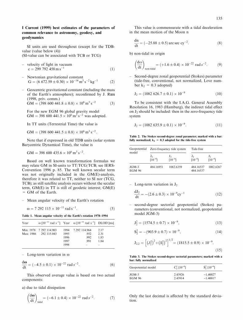
Table 1. Mean angular velocity of the Earth's rotation 1978±1994
Year x [10)11 rad s)1] Year x [10)11 rad s)1] DLOD [ms]
Min: 1978 7 292 114.903 1994 7.292 114.964 2.17Max: 1986 292 115.043 1995 .952 2.31
1996 .992 1.831997 .991 1.841998 ± ±
Table 2. The Stokes second-degree zonal parameter; marked with a bar:fully normalized; k2 = 0.3 adopted for the tide-free system
Geopotentialmodel
Zero-frequency tide system Tide-free
�J2 J2 �J2 J2[10)6] [10)6] [10)6] [10)6]
JGM-3 484.16951 1082.6359 484.16537 1082.6267EGM 96 484.16537
Table 3. The Stokes second-degree sectorial parameters; marked with abar: fully normalized
Geopotential model �C22 [10)6] �S2
2 [10)6]
JGM-3 2.43926 )1.40027EGM 96 2.43914 )1.40017
135
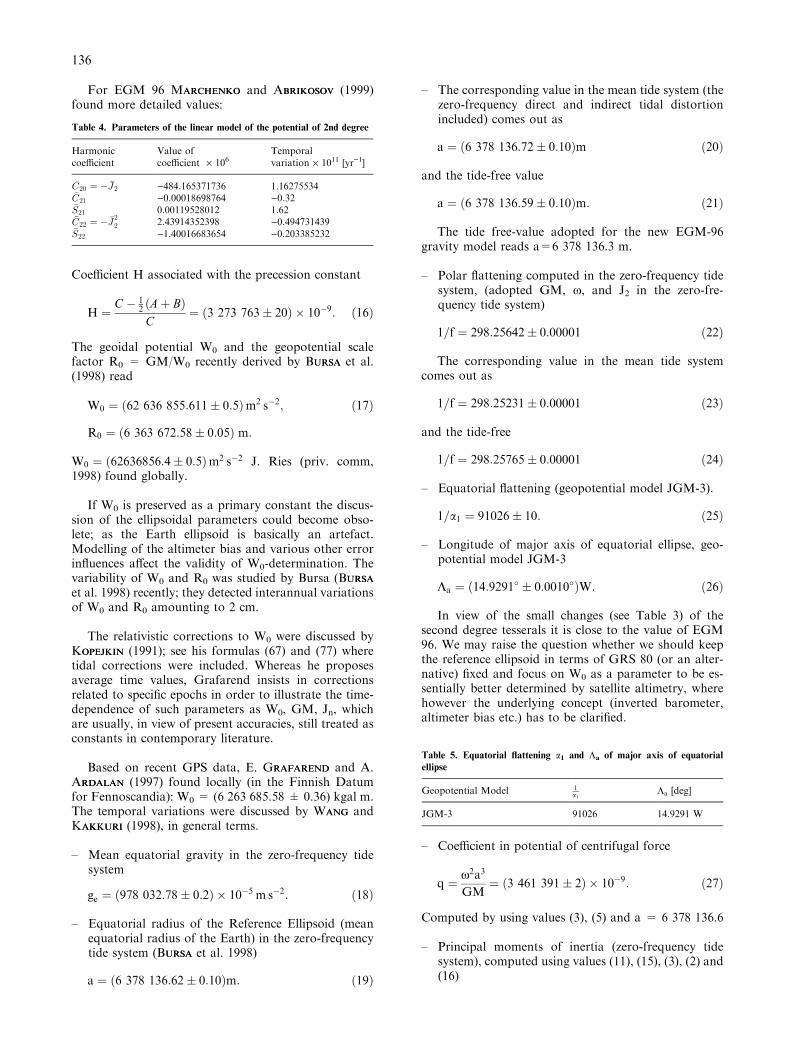
For EGM 96 MARCHENKOARCHENKO and ABRIKOSOVBRIKOSOV (1999)found more detailed values:
Coe�cient H associated with the precession constant
H � C ÿ 12 �A� B�
C� �3 273 763� 20� � 10ÿ9: �16�
The geoidal potential W0 and the geopotential scalefactor R0 = GM/W0 recently derived by BURSAURSA et al.(1998) read
W0 � �62 636 855:611� 0:5�m2 sÿ2; �17�R0 � �6 363 672:58� 0:05� m:
W0 � �62636856:4� 0:5�m2 sÿ2 J. Ries (priv. comm,1998) found globally.
If W0 is preserved as a primary constant the discus-sion of the ellipsoidal parameters could become obso-lete; as the Earth ellipsoid is basically an artefact.Modelling of the altimeter bias and various other errorin¯uences a�ect the validity of W0-determination. Thevariability of W0 and R0 was studied by Bursa (BURSAURSA
et al. 1998) recently; they detected interannual variationsof W0 and R0 amounting to 2 cm.
The relativistic corrections to W0 were discussed byKOPEJKINOPEJKIN (1991); see his formulas (67) and (77) wheretidal corrections were included. Whereas he proposesaverage time values, Grafarend insists in correctionsrelated to speci®c epochs in order to illustrate the time-dependence of such parameters as W0, GM, Jn, whichare usually, in view of present accuracies, still treated asconstants in contemporary literature.
Based on recent GPS data, E. GRAFARENDRAFAREND and A.ARDALANRDALAN (1997) found locally (in the Finnish Datumfor Fennoscandia): W0 = (6 263 685.58 � 0.36) kgal m.The temporal variations were discussed by WANGANG andKAKKURIAKKURI (1998), in general terms.
± Mean equatorial gravity in the zero-frequency tidesystem
ge � �978 032:78� 0:2� � 10ÿ5 m sÿ2: �18�
± Equatorial radius of the Reference Ellipsoid (meanequatorial radius of the Earth) in the zero-frequencytide system (BURSAURSA et al. 1998)
a � �6 378 136:62� 0:10�m: �19�
± The corresponding value in the mean tide system (thezero-frequency direct and indirect tidal distortionincluded) comes out as
a � �6 378 136:72� 0:10�m �20�
and the tide-free value
a � �6 378 136:59� 0:10�m: �21�
The tide free-value adopted for the new EGM-96gravity model reads a=6 378 136.3 m.
± Polar ¯attening computed in the zero-frequency tidesystem, (adopted GM, x, and J2 in the zero-fre-quency tide system)
1=f � 298:25642� 0:00001 �22�
The corresponding value in the mean tide systemcomes out as
1=f � 298:25231� 0:00001 �23�
and the tide-free
1=f � 298:25765� 0:00001 �24�
± Equatorial ¯attening (geopotential model JGM-3).
1=a1 � 91026� 10: �25�
± Longitude of major axis of equatorial ellipse, geo-potential model JGM-3
Ka � �14:9291� � 0:0010��W: �26�
In view of the small changes (see Table 3) of thesecond degree tesserals it is close to the value of EGM96. We may raise the question whether we should keepthe reference ellipsoid in terms of GRS 80 (or an alter-native) ®xed and focus on W0 as a parameter to be es-sentially better determined by satellite altimetry, wherehowever the underlying concept (inverted barometer,altimeter bias etc.) has to be clari®ed.
± Coe�cient in potential of centrifugal force
q � x2a3
GM� �3 461 391� 2� � 10ÿ9: �27�
Computed by using values (3), (5) and a = 6 378 136.6
± Principal moments of inertia (zero-frequency tidesystem), computed using values (11), (15), (3), (2) and(16)
Table 4. Parameters of the linear model of the potential of 2nd degree
Harmoniccoe�cient
Value ofcoe�cient ´ 106
Temporalvariation ´ 1011 [yr)1]
�C20 � ÿ �J2 )484.165371736 1.16275534�C21 )0.00018698764 )0.32�S21 0.00119528012 1.62�C22 � ÿ �J
22 2.43914352398 )0.494731439
�S22 )1.40016683654 )0.203385232
Table 5. Equatorial ¯attening a1 and La of major axis of equatorialellipse
Geopotential Model 1a1
La [deg]
JGM-3 91026 14.9291 W
136
CÿA
Ma20� J2 � 2J2;2 � �1086 � 267� 0:001� � 10ÿ6; �28�
Cÿ B
Ma20� J2 ÿ 2J2;2 � �1079:005� 0:001� � 10ÿ6;
BÿA
Ma20� 4J2;2 � �7:262� 0:004� � 10ÿ6;
Ma20 �GM
Ga20 � �2:43014� 0:00005�� 1038 kgm2; �29�
�a0 � 6 � 378 137m�;
CÿA � �2:6398� 0:0001� � 1035 kgm2; �30�Cÿ B � �2:6221� 0:0001� � 1035 kgm2;BÿA � �1:765� 0:001� � 1033 kgm2;
C
Ma20� J2
H� �330 701� 2� � 10ÿ6; �31�
A
Ma20� �329 615� 2� � 10ÿ6;
B
Ma20� �329 622� 2� � 10ÿ6; �32�
A � �8:0101� 0:0002� � 1037 kgm2;B � �8:0103� 0:0002� � 1037 kgm2; �33�C � �8:0365� 0:0002� � 1037 kgm2;
a � Cÿ B
A� �327 353� 6� � 10ÿ8;
c � BÿA
C� �2 196� 6� � 108
b � CÿA
B� �329 549� 6� � 10ÿ8
II Primary geodetic Parameters, discussion
It should be noted that parameters a, f, J2, ge, dependon the tidal system adopted. They have di�erent valuesin tide-free, mean or zero-frequency tidal systems.However, W0 and/or R0 are independent of tidal system(BURSAURSA 1995). The following relations can be used:
a�mean� � a�tide-free� � 1
2�1� ks�R0
dJ2ks; �34�
a�mean� � a�tide-free� � 3
2�1� ks� dJ2
ks;
a�zero-frequency� � a�tide-free� � 1
2R0dJ2; �35�
a�zero-frequency� � a�tide-free� � 3
2dJ2;
ks = 0.9383 is the secular Love number, dJ2 is the zero-frequency tidal distortion in J2. First, the internal con-
sistency of parameters a, W0, (R0) and ge should be ex-amined:
(i) If
a � 6 378 136:7m
is adopted as primary, the derived values are
W0 � 62 636 856:88m2 sÿ2; �36��R0 � 6 363 672:46m�; �37�
ge � 978 032:714� 10ÿ5 m sÿ2: �38�
(ii) If
W0 � �62 636 855:8� 0:5�m2 sÿ2;
R0 � �6 363 672:6� 0:05�m;
is adopted as primary, the derived values are (meansystem)
a � 6 378 136:62m; �39�
ge � 978 032:705� 10ÿ5 m sÿ2: �40�
(iii) If (18)
ge � �978 032:78� 0:2� � 10ÿ5 m sÿ2;
is adopted as primary, the derived values are
a � 6 378136:38m; �41�W0 � 62 636 858:8m2 sÿ2 �42��R0 � 6 363 672:26m�: �43�
There are no signi®cant discrepancies, the di�erencesare about the standard errors.
However, the inaccuracy in (iii) is much higher thanin (i) and/or (ii). That is why solution (iii) is irrelevant atpresent.
If the rounded value
W0 � �62 636 856:0� 0:5�m2 sÿ2 �44�R0 � �6 363 672:6� 0:1��m� �45�
is adopted as primary, then the derived length of thesemimajor axis in the mean tide system comes out as
a � �6 378 136:7� 0:1�m; �for zero-tide : 6 378 136:6��46�
which is just the rounded value (20), and (in the zerofrequency tide system)
ge � �978 032:7� 0:1� � 10ÿ5 m s2: �47�
137
However, SC 3 recommends that, at present, GRS 1980should be retained as the standard.
III Consistent set of fundamental constants (1997)
± Geocentric gravitational constant (including the massof the Earth's atmosphere)GM = (398 600 441.8 � 0.8) ´ 106 m3 s)2, [value(3)]
± Mean angular velocity of the Earth's rotationx=7 292 115 ´ 10)11 rad s)1 [value (5)]
± Second-degree zonal geopotential (Stokes) parameter(in the zero-frequency tide system, Epoch 1994)J2 = (1 082 635.9 � 0.1) ´ 10)9 [value (11)]
± Geoidal potentialW0 = (62 636 856.0 � 0.5) m2 s)2, [value (44)]
± Geopotential scale factorR0= GM/W0 = (6 363 672.6 � 0.05) m[value (45)]
± Mean equatorial radius (mean tide system)a = (6 378 136.7 � 0.1) m [value (46)]
± Mean polar ¯attening (mean tide system)1/f = 298.25231 � 0.00001 [value (23)]
± Mean equatorial gravityge = (978 032.78 � 0.1) ´ 10)5 m s)2, [value (18)].
GRAFARENDRAFAREND and ARDALANRDALAN (1999) have evaluated a(consistent) normal ®eld based on a unique set of currentbest values of four parameters (W°, x, J2 and GM) as apreliminary ``follow-up'' to the Geodetic ReferenceSystem GRS 80. It can lead to a level-ellipsoidal normalgravity ®eld with a spheroidal external ®eld in theSomigliana-Pizetti sense. By comparing the consequentvalues for the semimajor and semi-minor axes of therelated equipotential ellipsoid with the correspondingGRS-80 axes (based on the same theory) the authors endup with axes which deviate by )40 and )45 cm, re-spectively from GRS 80 axes and within standard devi-ations from the current values such as in (21); but no g-values are given until now.
IV Appendix
A1. Zero-frequency tidal distortion in J2
�J2 � ÿC20�
dJ2 � ksGML
GM
R
D�L
� �3R
a0
� �2
�E2 � d2L�
� ksGMS
GM
R
D�S
� �3R
a0
� �2
�E2 � d2S�;
E2 � ÿ 1
2� 3
4sin2 e0;
d2L � 3
4sin2 iL ÿ e2Lÿ �� 9
8e2L sin2 e0 ÿ sin2 iLÿ �
;
d2S � ÿ 3
4e2S 1ÿ 3
2sin2 e0
� �;
R � R0 1� 25
21v3qÿ 10
7v2J2
� �1=5
GML = 4 902.799 ´ 109 m3s)2
(selenocentric grav. Const.),GMS = 13 271 244.0 ´ 1013 m3s)2,DÅL = 384 400 km
(mean geocentric distance to the Moon),DÅS = 1 AU = 1.4959787 ´ 1011 m,a0 = 6 378 137 m
(scaling parameter associated with J2),e0 = 23°26'21.4'' (obliquity of the ecliptic),eL = 0.05490
(eccentricity of the orbit of the Moon),iL = 5°0.9'
(inclination of Moon's orbit to the ecliptic),eS = 0.01671
(eccentricity of the heliocentric orbit of the Earth-Moon barycenter),
m = a0/R0 = 1.0022729;ks = 0.9383
(secular-¯uid Love number associated with thezero-frequency second zonal tidal term);
dJ2 = )dC20 = (3.07531 ´ 10)8) ks (conventional);dJ2 � ÿdC20�1:37532� 10ÿ8�ks(fully normalized).L = LunarS = Solar
A2. De®nition
Because of tidal e�ects on various quantities, the tide-free, zero-frequency and mean values should be distin-guished as follows:
± A tide-free value is the quantity from which all tidale�ects have been removed.
± A zero-frequency value includes the indirect tidaldistortion, but not the direct distortion.
± A mean tide value included both direct and indirectpermanent tidal distortions.
Acknowledgement
This report is basically an updated version of M.Bursa's SC 3 report presented in 1995 with some newmaterial added.
References
BURSAURSA M (1992) The four primary geodetic parameters.Studia geoph. et geod. 36, 199±206
BURSAURSA M (1995) Special Commission 3, FundamentalConstants (SCFC), Report submitted to IAG,
138
IUGG Gen. Ass., Boulder, Travaux IAG, Tome 30,370±384, Paris 1995
BURSAURSA M, J KOUBAOUBA, K RADEJADEJ, SA TRUERUE, V VATRTATRT, MVOJTISKOVAOJTISKOVA (1997) Monitoring geoidal potential onthe basis of Topex/Poseidon altimeter data andEGM 96. Geodesy on the Move, IAG Sci. Ass. Riode Janeiro, Sept. 3±9, 1997, Springer Verlag 1998,352±358
BURSAURSA M, K RADEJADEJ, Z SIMAIMA, SA TRUERUE, V VATRTATRT (1997)Tests for accuracy of recent Geopotential models.Intern. Geoid Service, Bulletin 6, 167±188, Milano
BURSAURSA M, J KOUBAOUBA, K RADEJADEJ, SA TRUERUE, V VATRTATRT, MVOJTISKOVaOJTISKOVa (1998a) Monitoring Geoidal Potentialon the Basis of Topex/Poseidon Altimeter Data.Aviso Altimetry Newsletters 6, 130±131
BURSAURSA M, J KOUBAOUBA, A MULLERULLER, K RADEJADEJ, SA TRUERUE, VVATRTATRT, M VOJTISKOVAOJTISKOVA (1998b) Determination ofGeopotential Di�erences between local vertical Da-tums and realization of a world height system. Pres.Symp. IAG, MuÈ nchen
BURSAURSA M, GV DEMIANOVEMIANOV, MI YURKINAURKINA (1998c) On thedetermination of the earth's model ± the meanequipotential surface. Studia geoph. et geod. 42,467±471
BURSAURSA M, J KOUBAOUBA, K RADEJADEJ, SA TRUERUE, V VATRTATRT, MVOJTISKOVAOJTISKOVA (1998d) Mean earth's equipotentialsurface from Topex/Poseidon altimetry. Studia ge-oph. et geod. 42, 459±466
BURSAURSA M, J KOUBAOUBA, K RADEJADEJ, SA TRUERUE, V VATRTATRT, MVOJTISKOVAOJTISKOVA (1998e) Final Report on testing accu-racy of geopotential models EGMX05. EGM 96.Intern. Geoid Service, Bulletin N. 7
CHENGHENG MK, RJ EANESANES, BD TAPLEYAPLEY (1992) Tidal de-celeration of the Moon's mean motion. Geophys. J.Int. 108, 401±409
DEFRAIGNEEFRAIGNE P, V DEHANTEHANT (1996) Toward new non-rigidEarth nutations. Proc. Journ. de Reference 1995, ed.N. Capitaine, Warsaw, 45±52
DEHANTEHANT V, M CAPITAINEAPITAINE (1997) On the luni-solar pre-cession, the tilt-over-mode, and the oppolzer terms.Celest. Mech. (Manuscript in press)
DEHANTEHANT V, P DEFRAIGNEEFRAIGNE (1997) New nutation for anon-rigid Earth. Proc. Journ. Syst. de Reference,Sept. 1996 Paris, ed. N. Capitaine (Manuscript inpress)
DEHANTEHANT V, N CAPITAINEAPITAINE, P DEFRAIGNEEFRAIGNE (1997) Com-parison between values of the dynamical ¯atteningof the Earth derived from various kinds of obser-vations. Precession J2 Seismology, Proc. Journ. Syst.de Reference, Sept. 1996 Paris, ed. N. Capitaine(Manuscript in press)
DICKEYICKEY JO, PL BENDERENDER, JE FALLERALLER, XX NEWHALLEWHALL, RLRICKLEFSICKLEFS, JG RIESIES, PJ SHELUSHELUS, C VEILLETEILLET, ALWHIPPLEHIPPLE, JR WIANTIANT, JG WILLIAMSILLIAMS, CF YODERODER
(1994) Lunar laser ranging: a continual legacy of theApollo program. Science 265, 482±490
FUKUSHIMAUKUSHIMA T (1993) IAU Standards ± What's it? Pres.IAG. Gen. Ass. Beijing
FUKUSHIMAUKUSHIMA T (1994) Time ephemeris. Proc. of 26th
Symp. on ``Cel. Mechanics'', Tokyo, Japan, Jan 12±13, eds. H. Kinoshita and H. Nakai, 149±159
GRAFARENDRAFAREND E, F SANSOANSO (1984) The multibody space-time geodetic boundary value problem and theHonkasalo term. Geophys. J. R. astr. Soc. 78, 255±275
GRAFARENDRAFAREND E, AA ARDALANRDALAN (1997) W0: an estimate inthe Finnish Height Datum N60, epoch 1993.4, fromtwenty-®ve GPS points of the Baltic Sea Level Pro-ject. Journal of Geodesy, 71: 673±679
GRAFARENDRAFAREND E, AA ARDALANRDALAN (1999) The form param-eters of the Somigliana-Pizetti level ellipsoid fromcurrent best estimates of fundamental geodetic pa-rameters based on a functional analytical review ofthe Somigliana-Pizetti gravitational ®eld. Submittedto J. Geodesy
GROTENROTEN E (1994) A comment on fundamental geodeticconstants. IAG-SCFC 1991-1995, pres. at IAUGeneral Ass. The Hague
GROTENROTEN E (1994) Global tidal parameters. Studia ge-oph. et geod. 38, 221±234
KINOSHITAINOSHITA H (1994) Is the equatorial radius of the Eartha primary constant, or a de®ning constant? Studiageoph. et geod. 38, 2, 109±116
KOPEJKINOPEJKIN SM (1991) Relativistic manifestations ofgravitational ®elds in gravimetry and Geodesy.Manuscripta Geodaetica, 16, 5, 301±312
LEMOINEEMOINE et al. (1996) The development of the NASAGSFC and NIMA joint geopotential model. Paperpresented at IAG Symposium, Tokyo, Sept. 1996,McCarthy DD ed. (1992) IERS Standards. Techni-cal Note 13, Observatoire de Paris
MARCHENKOARCHENKO AN and OA ABRIKOSOVBRIKOSOV (1999) Evolutionof the Earth principal axes and moments of inertia.J. Geodesy, (in press )
MCCCARTHYARTHY DD (1996) IERS ConventionsNEREMEREM RS, BF CHAOHAO, AY AUU, JC CHANHAN, SM KLOSKOLOSKO,
NK PAVLISAVLIS, RG WILLIAMSONILLIAMSON (1993) Temporalvariations of the Earth's gravitational ®eld fromsatellite laser ranging to LAGEOS. Geophys. Res.Let. 20, 7, 595±598
NEREMEREM RS, FJ LERCHERCH, RG WILLIAMSONILLIAMSON, SM KLOSKOLOSKO,JW ROBBINSOBBINS, GB PATELATEL (1994) Gravity model im-provement using the DORIS tracking system on theSPOT 2 satellite. JGR 99, B2
NEREMEREM RS ET ALET AL (1994) Gravity model development forTOPEX/POSEIDON: Joint gravity models 1 and 2.JGR 99, C12, 24, 421±24, 447
NESVORNYESVORNYÂ D, Z SIMAIMA (1994) Re®nement of the geopo-tential scale factor R0 on the satellite altimetry basis.Earth, Moon, and Planets 65, 79±88
NIMA, National Imagery and Mapping Agency (1997)Technical Report TR 8350.2, Third Edition, De-partment of Defense, World Geodetic System, 1984,Its De®nition and Relationships with Local Geo-detic Systems
RAPPAPP RH (1987) An estimate of equatorial gravity fromterrestrial and satellite data. GRL 14, 7, 730±732
RAPPAPP RH (1993) Geoid undulation accuracy. IEEETransaction on geoscience and remote sensing 31, 2,365±370
RAPPAPP RH, Y YII, YM WANGANG (1994) Mean sea surfaceand geoid gradient comparison with Topex altimeterdata. JGR 99, C12, 24, 657±24, 667
139
RIESIES JC, RJ EANESANES, CK SHUMHUM, MM WATKINSATKINS (1992)Progress in the determination of the gravitationalcoe�cient of the Earth, GRL 19, 6, 529±31
RIESIES JC (1998) Personal communicationsSTEPHENSONTEPHENSON FR, LV MORRISONORRISON (1994) Long-term
¯uctuations in the Earth's rotation: 700 BC to AD1990. Phil. Trans. Royal Soc. (London) Ser. A
WANGANG Z, J KAKKURIAKKURI (1998) The time dependency ofgravity potential on the geoid. (Submitted to J.Geodesy)
WILLIAMSILLIAMS JG, XX NEWHALLEWHALL, JO DICKEYICKEY (1993) Incontributions of space geodesy to geodynamics:
Earth Dynamics, eds. DE Smith, DL Turcotte.Geodynamics series 24, AGU, Washington, 83
WILLIAMSILLIAMS JG (1994) Contributions to the Earth'sobliquity rate, precession and nutation. Astron. J.108, 2, 711±724
YANAN HJ, E GROTENROTEN (1994) The celestial and terrestrialdeparture points and their various aspects in geodesyand astrometry. Studia geoph. et geod. 38, 2, 117±130
YURKINAURKINA MI (1993) Determination of Stokes' constantsrespecting zero-frequency tidal term due to theMoon and the Sun. Studia geoph. et geod. 37, 4,317±325
140
IAG ON THE INTERNET (http://www.gfy.ku.dk/�iag)By Ole B. Andersen, IAG information Editor
During the last four years the IAG central bureau hasmaintained a home page on the Internet as an open andup-to-date information medium.
On these internet pages it is possible to access infor-mation for general use relevant to the IAG community.
At the IAG internet pages you will also ®nd the mostrecent version of documents in theGeodesistsHandbook.
You will ®nd the IAG at the following Internet address
http://www.gfy.ku.dk/�iag
Among the major topics that is presently available onthe IAG home page is:
Structure and General informationStructure of IAG for 1999±2003Structure of IUGG for 1999±2003IAG addressesIAG email listReport of IAG meetings
IAG awards and funds
Young Authors Award informationGuy Bomford price, Levallois medalIAG fundIAG Travel award
MeetingMeeting calendarMeeting announcements
School and Training coursesIAG sponsored schoolOther schools relevant to geodesy
IAG publicationsGeodesists HandbookIAG newsletterIAG Travaux
Links to Journal of GeodesyBibliographic services
IfaG Bibliographic servicesIAG Fast bibliographyOther bibliographic services.
Geoscience WWW links
Links to IUGGLinks to geoscience organisations
Other informationNon-commercial geodetic productsBooks etc.
Please note that this list is far from complete and theInternet pages are regularly updated and revised.
IAG Sections on the Internet
All ®ve sections of IAG have established Internet sites,where information about their respective structure,commissions, special commissions, special study groupsand international services can be obtained.
Sec 1http://www.gmat.unsw.edu.au/snap/gps/iag_sec-tion1.htm
Sec 2http://geodesy.eng.ohio-state.edu/iag_sectionII/
Sec 3http://www.ucalgary.ca/�sideris/IAG/sectionIII.html
Sec 4http://www.gik.uni-karlsruhe.de/iag_sectionIV.html
Sec 5http://www.oma.be/KSB-ORB/IAG-S5/main.html
141
GEODETIC DATA CENTRES
INTERNATIONAL DATA CENTERS
Bureau Gravimetrique Internationalc/o CNES-GRGS, 18 Avenue Edouard Belin31055 Toulouse Cedex, FrancePhone: (33) 61 27 44 27
Bureau Central du Service Internatioal de la RotationTerrestre61 avenue de l'Observatoire, 75014 Paris, FrancePhone: (33) 1 40 51 22 26
Commission for Geodesy in Africa, Com. XIc/o I.G.C.I., B.P. 3862, Abidjan 01Cote d'Ivoire
Commission on International Coordination of SpaceTechniques for Geodesy and GeodynamicsCom. VIII c/o G. Beutler, DirectorAstronomical Institute of Bern, Sidlerstrasse 5CH-3012 Bern, SwizerlandPhone: (41) 31 631 8591Fax: (41) 31 631 [email protected]
Committee on Space Research (COSPAR)51, boulevard de Montmorency75016 Paris, FrancePhone: (33) 1 45 25 06 79
Department of Geomatic EngineeringUniversity College London, Gower St.London WC1E 6BT, United KingdomPhone: (44)-171-380-7028Fax: (44)-171-380-0453
Federation of Astronomical and Geophysical Services(FAGS)c/o D. Pugh, Institute of Oceanographic ScienceBidston Observatory, Brook Rd. WormleyGodalming, Surrey GU8 5UB, United KingdomPhone: (44) 428 68 4141Fax: (44) 428 68 [email protected].
ICSU Panel on World Data CentersNOAA/EDIS, 325 BroadwayBoulder CO 80303, USAPhone: (1) 303 497 37 98
International Association of Geodesyc/o C.C. Tscherning, Department of GeophysicsJuliane Maries Vej 30, 2100 Copenhagen O. DenmarkPhone: (45) 3532 0601Fax: (45) 3536 [email protected]/�iagInternational Center on Recent Crustal Movements250 66 Zdiby 98, Praha-Vychod, Czechoslovakia
International Geoid ServiceDipart. di Ingegnerica IdraulicaAmbientale e del Rilevamento, Politechnico di MilanoPiazza Leonardo da Vinci 32, I-20133 Milano, ItalyPhone: (39) 2 2399 6504Fax: (39) 2 2399 6530
Inter-Union Commission on the Lithosphere (ICL)State University Utrecht, Institute of Earth ScienceP.O. Box 80021, 3508 TA Utrecht, Netherlands
NASA Geodynamics ProgramGeodynamics Branch Code FRG-2,Greenbelt, Maryland, USA NASA HeadquatersWashington DC 20546, USA
North American Datum,National Geodetic SurveyNOAA/NOS, 6001 Executive Bld.Rockville, Maryland 20852, USAPhone: (1) 301 443 82 04
Permanent Service for Mean Sea LevelInst. of Oceanographic SciencesBidston Observatory Birkenhead,L43 7RA Merseyside, United KingdomPhone: (44) 51 653 86 33
142
Sub-Commission for the Europe and Reference Frame(EUREF)c/o Deutsches GeodaÈ tisches ForschungsinstitutMarstallplatz 8, Munich 22, Germany
WDC-B for Solid Earth PhysicsMaintained by Geophysical center, RAS,Molodezhnaya, 3 Moscow 117296, Russiawww.wdcb.rssi.ru/WDCB/Wdc-sep.shtmp
World Data Center ARotation of the Earth, U.S. Naval ObservatoryTime Service Division, Washington D.C. 20390USA
World Data Center for Solid Earth Geophysics325 Broadway, BoulderColorado 80803, USA
NATIONAL DATA CENTERS
Algeria
Service de traitement des Donne es Ge ode siquesInstitut National de Cartographie et Te ledetection,123, Rue de Tripoli, Hussein-Dey, Alger, AlgeriaPhone: (213) 02 23 43 76 Fax: (213) 02 23 43 81E-mail: [email protected]
Australia
Australia Geological Survey Organisation (AGSO)GPO Box 378, Canberra, Australian Capital Territory2601, Australia Phone: (61) 2 6249 9111Fax: (61) 2 6249 9999 Internet: www.agso.gov.au
Australian Surveying and Land Information Group(AUSLIG), P.O. Box 2, Belconnen, Australian CapitalTerritory 2616, AustraliaPhone: (61) 2 6201 4201 Fax: (61) 2 6201 4366Internet: www.auslig.gov.au/geodesy
National Tidal FacilityThe Flinders University of South Australia,GPO Box 2100, Adelaide,South Australia 5001, AustraliaPhone: (61)-8-8201-7532 Fax: (61)-8-8201-7523Internet: www.ntf.¯inders.edu.au
Austria
Bundesamt fuÈ r Eich und VermessungswesenSchi�amtsgasse 1-3, Postfach 50, A-1025 Wien,Austria Phone: (43) 1 21176 3201 Fax: (43) 1 2161062
Insitute of Theoretical GeodesyTechnicalUniversity Graz, Steyrergasse 30,A-8010 Graz, Austria Phone: (43) 316 873 6346Fax: (43) 316 813247E-mail: [email protected]
Space Geodesy DivisionInstitute of Space Research of the Austrian Academyof Sciences, LustbuÈ helstrasse 46, A-8010 Graz, AustriaPhone: (43) 316 472231 Fax: (43) 316 462678E-mail: [email protected]
Belgium
De partement d'Astronomie Fondamentale et deGeodynamiqueObservatoire Royal de Belgique, Avenue Circulaire 3,B-1180 Brussels, Belgium
De partement de Ge ode sieInstitut Geographique National, 13, Abbaye de laCambre, B-1050 Brussels, Belgium
Brazil
Departamento de GeodesiaIBGE, Ave Brasil, 15671, Parada de Lucas,21241-051 Rio de Janeiro, Brazil
143
Phone: (55) 21 391 3674, 482-8217Fax: (55) 21 481 2747E-mail: [email protected]: www.ibge.gov.br
Burundi
Institut Geographique de BurundiDe partement de Topographie et Cartographie,B.P. 34, Gitega, Burundi
Canada
Canadian Geodetic Information SystemNatural Resources Canada, Geodetic Survey division,615 Booth Street, Ottawa KIA 0E9, Ontario, CanadaPhone: (1) 613 995 4410 Fax: (1) 613 995 3215E-mail: [email protected] Internet:www.emr.ca/�jtod/geophys
China
China Cartographic Publishing HouseBeijing, China
Chinese Academy of Surveying and Mapping16 Beitaping Road, Beijing 100039, ChinaInstitute of Geodesy and Geophysics, CAS 54,Xu Dong Road, 430077 Wuhan, China
National Bureau of Surveying and MappingBaiwanzhuang, Beijing, 100830, China
National Geomatics Center of ChinaBeijing China
Denmark
National Survey and Cadastre, Geodetic DivisionRentemestervej 8, DK-2400 Copenhagen NV.,Denmark
Finland
Finnish Geodetic InstituteP.O. Box 15 (Geodeetinrinne 2), FIN-02431,Finland Phone: (358)-9-295 550Fax: (358)-9-295 552 00 E-mail: fgi@fgi.®
France
De partement Banque de Donnees du Sous-SolBureau de Recherches Geologiques et Minieres, Dept.BSS, B.P. 6009, 45060 Orleans Cedex, France
Groupe de Recherche de Ge ode sie Spatiale (GRGS)GRGS/Instiut Geographique National, 2, AvenuePasteur, B.P. 68, F-94160 Saint-Mande, France
O�ce de la Recherche Scienti®que et TechniqueOutre-Mer (ORSTOM), 70-74 route d¢Aulney, F-93140Bondy, France
Section Ge ode sie-Ge ophysqueEtablissemnt Principal du Service Hydrographique etOcanographique de la Marine, 13, Rue du Chantellier,B.P. 426, F-29275 Brest Cedex, France
Service de la Ge ode sie et du NivellementInstitut Geographique National, 2, Avenue Pasteur,B.P. 68, F-29275 Saint-Mande, France
Germany
Arbeitsgemeinschaft der Vermessungsverwaltungen derLaÈ nder der Bundesrepublik Deutschland (AdV)GeschaÈ ftsstelle: Landesbetrieb, Landesvermessung undGeobasisinformation, Neudersachsen, Postfach 510450,WarmbuÈ chenkamp 2, D-30634 Hannover, GermanyPhone: (49)-511-64609-151 Fax: (49)-511-64609-162
Bundesamt fuÈ r Kartographie und GeodaÈ sieRichard-Strauss-Allee 11, D-60598 Frankfurt/Main,Germany Phone: (49)-0-6963331 Fax: (49)-0-696333235
Bundesamt fuÈ r Seeschi�ahrt und Hydrographie (BSH)Dierkower Damm 45, D-18146 Rostock, GermanyPhone: (49)-381-4563602 Fax: (49)-381-4563948
EUROLAS Data Center (EDC)Deutsches GeodaÈ tisches Forschungsinstitut, Abt. I,Marstallplatz 8, D-8000 MuÈ nchen 22, Germany
National Gravity Data BaseDeutsches GeodaÈ tisches Forschungsinstitut (DGFI),Abt. I, Marstallplatz 8, D-8000 MuÈ nchen 22, Germany
Point of Contact for Geodetic DataArbeitsgemeinschaft der Vermessungsverwaltungendeutscher Langer (AdV), Niedersachsischer Ministerdes Inner, D-3000 Hannover, Germany
Topography Data BaseInstitut fuÈ r Angewandte GeodaÈ sie (IFAG), RichardStrauss Allee 11, D-6000 Frankfurt a.M., 70, Germany
Greece
Department of Geodesy and SurveyingUniversity of Thessaloniki, POB 492, Thessaloniki,Greece
Dionysos Satellite ObservatoryGeodesy Department, National Technical University,Zographou 15773, Athens, Greece
Hellenic Army Geographic ServicePedion Areas, Greece
Hungary
EoÈ tvoÈ s LoraÁ nd Geophysical Institute of HungaryP.O. Box 35, H-1440 Budapest, HungaryPhone: (36) 1 252 4999 Fax: (36) 1 163 7256
144
ToÁ th Agoston Mapping and Military Geographic Instituteof the Hungarian ArmyP.O. Box 37, H-1525 Budapest 114, HungaryPhone: (36) 1 332 0161Fax: (36) 1 332 0161
Iceland
Iceland Geodetic SurveyP.O. Box 5536, 05 Reykjavik, Iceland
Icelandic National Energy AuthorityGrensasvegur 9, 108 Reykjavik, Iceland
Indonesia
National Coordination Agency for Surveys and MappingJalan Raya Bogor, Km. 46, Cibinong,Bogor, Indonesia
Ireland
Michael CoryController of Mapping, Ordnance Survey O�ce,Phoenix Park, Dublin 8, IrelandPhone: (353) (0) 1 802 5300 Fax: (353) (0) 1 820 4156
Japan
Earthquake Research InstituteUniversity of Tokyo, Earthquake PredictionResearch Center, 1-1, Yayoi 1, Bunkyo-ku,Tokyo 113-0032,Japan Phone: (81) 3 5689 7264 Fax: (81) 3 5689 7234
Earthquake Research InstituteUniversity of Tokyo, Earthquake Observation Center,1-1, Yayoi 1, Bunkyo-ku, Tokyo 113-0032, JapanPhone: (81) 3 3813 7627 Fax: (81) 3 3813 8026
Geographical Survey InstituteKitasato-1, Tsukuba, Ibaraki 305-0811, JapanPhone: (81)-298-64-1111 Fax: (81)-298-64-1802
Hydrographic DepartmentMaritime Safety Agency, 3-1 Tsukiji 5, Chuo-ku,Tokyo 104-0045, Japan Phone: (81) 3 3541 3685Fax: (81) 3 3248 1250
Mizusawa Astro Geodynamics ObservatoryNational Astronomical Observatory, 12,Hoshigaoka-cho 2, Mizusawan, Iwate 023-0861, JapanPhone: (81)-197-22-7111 Fax: (81)-197-22-7120
National Research Institute for Earth Science andDisaster PreventionTenodai 3-1, Tsukuba, Ibaraki 305-0006, JapanPhone: (81) 298 51 1611 Fax: (81) 298 51 5658
Observation Center for Prediction of Earthquakesand Volcanic EruptionsGraduate School of Science, Tohoku University,Aobayama, Aoba-ku, Sendai, Miyagi 980, JapanPhone: (81)-22-225-1950 Fax: (81)22±264-3292
Ocean Research Institute, University of Tokyo15-1, Minamidai 1, Nakano-ku, Tokyo 164, JapanPhone: (81) 3 5351 6430 Fax: 3 3377 3292
Research Center for Earthquake PredictionHokkaido University, Kita-10, Nishi-8, Kita-ku,Sapporo, Hokkaido, 060, JapanPhone: (81) 11 716 8377 Fax: (81) 11 746 7404
Kenya
Research Center for Earthquake PredictionDisaster Prevention Research Institute, KyotoUniversity, Gokasho, Uji, Kyoto 611, JapanPhone: (81)-774-38-4193Fax: (81)-774-38-4190 Survey of Kenya,P.O. Box 30046, Nairobi, Kenya
Madagascar
National Institute of Geodesy and CartographyLalana Dama-tsoha Raza®ntsalamaJ.B., B.P. 323, 101 Antananarivo, Madagascar
Mexico
Departamento de GeodesiaDireccion General de Geogra®a, San Antonio Abad124-PB, Col. Transito, Del. Cuavi, 06820, Mexico
Netherlands
Amsterdam Ordnance DatumRWS/Survey Department, Kanaalweg 3b, Delft,P.O. Box 5023, 2600 GA, Delft, Netherlands
Department of Triangulationhoofdirectie Kadaster, Waltersingel 1, 7314NK Apeldoorn, Netherlands
New Zealand
Hydrographic O�ceP.O. Box 33-341, Takapuna 9, Auckland, New Zealand
Institute of Geological & Nuclear SciencesP.O. Box 30-368, Lower Hutt, New ZealandPhone: (64) 4 570 1444Fax: (64) 4 570 1440E-mail: [email protected] Internet: www.gns.cri.nz
Land Information New ZealandHead O�ce, P.O. Box 5501, Wellington, New ZealandPhone: (64) 4 460 0110 Fax: (64) 4 460 0575E-mail: [email protected] Internet: www.linz.govt.nz
Portugal
Norwegian Mapping AuthorityKartverksveien 21, N-3500 HEnefoss, Norway
Instituto de Investigacao Cienti®ca TropicalCentro de Geodesia, R. da Jungqueira, 534, 1300-341Lisboa, Portugal
145
Instituto Portugues de Cartogra®a e CadastroR. Artilharia Um, 107, 1099-052 Lisboa, Portugal
Laborato rio Nacional de Engenharia CivilNu cleo de Medidas Geode sicas, Av. do Brasil,101, 1700-066 Lisboa, Portugal
South Africa
Surveys and MappingPrivate Bag, 7705 Mowbray, Republic of South Africa
Centro Nacional de Informacion Geogra®caIbanez de Ibero 3, 28003 Madrid, SpainPhone: (34) 91 597 97 39 Fax: (34) 91 597 94 18
Spain
Instituto de Astronomia y GeodesiaUCM-CSIC, Facultad de Matematicas, UniversidadeCompltense, Ciudad Universitaria, 28040 Madrid, SpainPhone: (34) 91 39 445 82 Fax: (34) 91 39 446 15
Instituto Geogra®co NacionalIbanez de Ibero 3, 28003 Madrid, SpainPhone: (34) 91 597 9000 Fax: (34) 91 597 97 58
Servei de GeodesiaInstitut Cartograifc de Catalunya, Parc de Montjuic,08006 Barcelona, Spain Phone: (34) 93 42 529 00Fax: (34) 93 42 674 42
Sweden
National Land SurveyDivision of Geodetic Research, S-801 82 Gavle, Sweden
Switzerland
Astronomical Institute University of BerneSidlerstrasse 5, CH-3012 Berne, Switzerland
Bundesamt fuÈ r LandestopographieSeftigenstrasse 264, CH-3084 Wabern, Switzerland
Swiss Federal Institute of TechnologyZurich (ETH Zurich), ETH-Honggerberg,CH-8093 Zurich Switzerland
Syria
General Establishment of SurveyingDepartment of Geodesy, P.O. Box 3094,Damascus, Syria
Thailand
Royal Thai Survey DepartmentSupreme Command Headquarters, KanlayanamaitriSt., Bangkok 10200, Thailand
Tunisia
Direction de la Ge ode sie et du NivellementO�ce de la Topographie et de la Cartographie, CiteOlympique, Tunis, Tunisia
Turkey
General command of MappingHarita Genel Komutanligi, 06100, Cebeci, Ankara,Turkey
United Kingdom
British Geological SurveyRegional Geophysics Group, Nicker Hill, Keyworth,Nottingham BG 12 5GG, United KingdomPhone: (44)-0115 9363100 Fax: (44)-0115 9363145
British Geological Survey, Marine Geophysics UnitMurchison House, West Mains House, EdinburghEHEH9 3LA, United KingdomPhone: (44)-0131 667 1000
Deacon Oceanographic LaboratoryBrook Road, Wormley, Godalming, Surrey GU8 5UB,United Kingdom
Earth Observation Data Centre, Space DepartmentRoyal Aircraft Establishment, Farnborough, HantsGU14 6TD, United Kingdom
Hydrographic O�cePhysical Oceanography, Taunton, Somerset TA1 2DN,United KingdomPhone: (44)-01823337900 Fax: (44)-01823284077
Institute of Geological SciencesMarine Geophysics Unit, Murchison House,West Mains Roads, Edingburgh EH9 3LA,United Kingdom
Military Survey, Clarke BuildingElmwood Avenue, Feltham, Middlesex TW 13 7AE,United Kingdom Phone: (44)-0181 818 2225
Ordnance Survey of Great BritainGeodetic Services Branch, Romsey Road, Maybush,Southampton SO9 4DH, United KingdomPhone: (44)-01703 792731 Fax: (44)-01703-792687
Ordnance Survey of Great BritainOrdnance Survey International, Romsey Road,Maybush, Southampton SO9 4DH, United KingdomPhone: (44)-01703 792659
Proudman Oceanographic LaboratoryBidston Observatory, Birkenhead, Merseyside L43 7RA,United KingdomPhone: (44)-0151 653 8633 Fax: (44)-0151 653 6269
Royal Greenwich ObservatorySpace Geodesy Group and Nautical, Almanac O�ce,Madingley Road, Cambridge CB3 OEZUnited Kingdom
The EPSRC Geophysical Data FacilityRutherford Appleton Laboratory, Chilton, Didcot,Oxon OX1 1 OQX, United Kingdom
146
World Data Centre CI for Solar Terrestrial PhysicsRutherford Appleton Laboratory, Chilton, Didcot,Oxon OX1 1 OQX, United Kingdom
Uruguay
Servicio Geogra®co MilitarIra. Division (Geodesia), 8 de Octubre 3255,Montevideo, Uruguay
USA
CORS GPS Network Data ArchiveNational Geodetic Survey, NOAA, Code N/NGSSSMC-3, 1315 East-West Highway, MD 20910-3282,USA
Crustal Dynamics Data Information SystemNASA/Goddard Space Flight Center, Greenbelt,MD 20771, USA
Eastern-National Cartographic Information Center(E-NCIC), 536 National Center, Reston, VA 22092,USA
National Cartographic Information CenterU.S. Geological Survey, 507 National Center, Reston,VA 22092, USA
National Geodetic Information CenterNational Geodetic Survey, NOAA, Code N/NGSSSMC-3, 1315 East-West Highway, Silver Spring,MD 20910-3282, USA
National Geophysical Data CenterNOAA, Code E/GC4, 325 Broadway, Boulder,CO 80303-3328, USA
147
EDUCATIONAL ESTABLISHMENTS
Australia
Centre for Spatial Information ScienceSchool of Geography & Environomental Science,University of Tasmania, GPO Box 252-76, Hobart,Tasmania 7001, AustraliaPhone: (61)-3-6226-2134, Fax: (61)-3-6224-0282E-mail: [email protected]: www.utas.edu.au/docs/geomatics/
Department of CivilSurveying and Environmental Engineering,University of Newcastle, Newcastle, New South Wales2308, AustraliaPhone: (61) 2 4921 6058 Fax: (61) 2 4921 6991E-mail: [email protected] Internet:www.eng.newcastle.edu.au/ce/
Department of GeomaticsUniversity of Melbourne, Parkville,Victoria 3052, AustraliaPhone: (61)-3-344-6806 Fax: (61)-3-347-2916E-mail: [email protected]: www.geom.unimelb.edu.au
Department of Land InformationRoyal Melbourne Institute of Technology,PO Box 2476V, Melbourne, Victoria 3001, AustraliaPhone: (61)-3-9925-2213 Fax: (61)-3-9663-2517E-mail: [email protected]: www.ls.rmit.edu.au
School of GeoinformaticsPlanning and Building, University of South Australia,GPO Box 2471, South Australia 5001, AustraliaPhone: (61) 8 8302 2227 Fax: (61) 8 8302 2252E-mail: [email protected]: www.unisa.edu.au/gbp/index.htm
School of Geomatic EngineeringUniversity of New South Wales, Sydney,New South Wales 2052, AustraliaPhone: (61)-2-9385-4182 Fax: (61)-2-9313-7493
E-mail: [email protected]: www.gmat.edu.au
School of Planning, Landscape, Architectureand SurveyingFaculty of Built Environment and Engineering,Queensland University of Technology, GPO Box 2434,Brisbane, Queensland 4001,Phone: (61)-7-3864-2671 Fax: (61)-7-3864-1809E-mail: [email protected] Internet: www.bee.qut.edu.au/plas/fplasweb/SURVEYING.htm
School of Spatial SciencesCurtin University of Technology, GPO Box U1987,Perth, Western Australia 6845, AustraliaPhone: (61) 8 9266 7565 Fax: (61) 8 9266 2703E-mail: [email protected]: www.cage.curtin.edu.au/surveying
Austria
Technical University GrazGeodetic Institutes, Steyrergasse 30,A-8010 Graz, AustriaPhone: (43)-316-873-6331 Fax: (43)-316-827685E-mail: [email protected]
Vienna University of TechnologyGeodetic Institutes, Gusshausstrasse 27-29, A-1040Vienna, AustriaPhone: (43) 222 58801 3814 Fax: (43) 222 5056268E-mail: [email protected]
Belgium
Ecole Royale MilitaireChaire d'Astronomie-Ge ode sie, 30,Avenue de la Renaissance, B-1040 Bruxelles, BelgiumPhone: 2 735 51 52 Fax: 2 735 24 21
Katholieke Universiteit LeuvenAstronomisch Institut, Celectijnenlaan, 200 B,B-3001 Leuven, BelgiumPhone: 16 20 06 56 Fax: 16 20 53 08
148
Universite Cahtolique de LouvainUnite d'Astronomie et de Ge ophysique, 2, Chemin duCyclotron, B-1348 Louvain-la-Neuve, BelgiumPhone: 10 47 32 97 Fax: 10 47 47 22
Universite de LiegeInstitut d'Astrophysique, 5, Avenue de Cointe, B-4200Liege, BelgiumPhone: 41 52 99 80 Fax: 41 52 74 74
Brazil
Escola Politecnica da USPDepartamento de Engenharia de Transportes, CaixaPostal 61548, 0524-970, Sao Paulo, BrazilPhone: (55)-11-818-5208 Fax: (55)-11-818-5716
Instituto Militar de EngenhariaDepartamento de Cartograifa, DE6 Praca Gen.Tiburcio 80, 22290-270 Rio de Janeiro-RJ, Brazil
Universidade Federal de PernambucoDepartamento de Engenharia Cartogra®ca, RuaAcademico helio Ramos S/N, Cidade Universitaria,50741, Recife ± Pe, Brazil
Universidade Federal do ParanaCurso de Pos-Graduacao em Ciencias Geodesicas,Departamento de Geomatica,P.O. Box 019001, 81531-990 Curitiba-PR, BrazilPhone: (55) 41 361 3153 Fax: (55) 41 266 2393E-mail: [email protected]
Canada
Universite LavalDepartement des sciences ge ode siques et de te le de tection,Pavillon Louis-Jacques Casault, Sainte-Foy, Quebec,G1K 7P4, CanadaPhone: (1) 418 656 2530 Fax: (1) 418 656 7411E-mail: �g@�g.ulaval.caInternet: www:http://forestgeomat.for.ulaval.ca
University of CalgaryDepartment of Geomatics Engineering, 2500 UniversityDrive, N.W., Calgary, Alberta T2N 1N4, CanadaPhone: (1) 403 220 5834 Fax: (1) 403 284 1980E-mail: [email protected]: www:http://www.ensu.ucalgary.ca/
University of New BrunswickDe partement des Sciences Ge omatiques, P.O. Box 4400,Fredicton, New Brunswick, E3B 5A#, CanadaPhone: (1) 506 453 4698 Fax: (1) 506 453 4943E-mail: [email protected], Internet:www:http://degaulle.hil.unb.ca/Geodesy/index.html
University of TorontoProgram in Geomatics, Department of Geography,Erindale Campus, Mississauga, Ontario, Canada L5L1C6 Phone: (1) 905 828 3861 Fax: (1) 905 828 5273E-mail: [email protected]: www:http://www.geog.utronto.ca
China
Wuhan Technical University of Surveying and MappingWuhan, 430079, China
Zheng Zou Technical School of Surveying and MappingZheng Zhou, China
Denmark
Institut for Samfundsudvikling og PlanlaegningAalborg Universitetscenter, Fibigerstrade 11, DK- 9220Aalborg Oest, Denmark
Niels Bohr Institute for AstronomyPhysics and Geophysics, Department of Geophysics,University of Copenhagen, Juliane Maries Vej 30,DK-2100 Copenhagen, DenmarkPhone: (45) 3532 0601 Fax: (45) 3536 5357
Finland
Department of GeophysicsUniversity of Helsinki,Fabianinkatu 24 A, SF-00100 Helsinki, FinlandPhone: (358) 1911 Fax: (358) 1913385
France
Centre d'Etude Spatiale des RayonnementsUniversite Paul Sabatier, 9, Avenue du Colonel Roche,B.P. 4346, F-31029 Toulouse Cedex,Phone: (33) 61 55 66 66 Fax: (33) 61 55 67 01
Ecole Nationale des Sciences Ge ographiques2, Avenue Pasteur, B.P. 68, F-94160 Saint-Mande ,France, Phone: (33) 1 43 98 80 52Fax: (33) 1 43 98 84 65
Ecole Nationale Superieure des Arts et Insustriesde Strasbourg24, Rue de la Victoire, F-67084 Strasbourg Cedex,France, Phone: (33) 88 35 55 05Fax: (33) 88 24 14 90
Ecole Superiure des Ge ometres et TopographesConservatoire National des Arts et metiers, 18, AlleeJean Rostand, B.P. 77, F-91002 Evry Cedex, FrancePhone: (33) 60779740 Fax: (33)60779690
Observatoire de ParisService Scolaire, 61, Avenue de l'Observatoire,F-75014 Paris, FrancePhone: (33) 40 51 21 70
Germany
Institut fuÈ r Stadtebau, Bodenordnung und KulturtechnikMeckenheimer Allee 172, 5300 Bonn 1, GermanyPhone: (49) 0228-737 499 Fax: (49) 0228-733 281
Technische Hochschule AachenLehrstuhl fuÈ r GeodaÈ sie II, Templergraben 55, 5100
149
Aachen, GermanyPhone: (49) 0241-80 53 00 Fax: (49) 0241-80 44 13
Technische Hochschule DarmstadtInstitut fuÈ r Physikalische GeodoÄ sie, Petersenstrasse 13,6100 Darmstadt, GermanyPhone: (49) 06151-163 109 Fax: (49) 06151-165 489
Technische Hochschule DarmstadtGeodaÈ tisches Institut, Petersenstrasse 13, 6100Darmstadt, GermanyPhone: (49) 06151-162 147 Fax: (49) 06151-164 047
Technische Hochschule DarmstadtFB Phtogrammetrie im FB 12, Vermessungswesen,Petersenstrasse 13, 6100 Darmstadt, GermanyPhone: (49) 06151-162 035 Fax: (49) 06151-165 489
Technische UniversitaÈ t BerlinFachgebiet GeodaÈ sie und Ausgleichsrechnung, Strassedes 17. Juni 135, 1000 Berlin 12, GermanyPhone: (49) 030-314 22 41/32 08Fax: (49) 030-31 42 32 22
Technische UniversitaÈ t BerlinInstitut fuÈ r Astronomische und Physikalische GeodaÈ sie,Sekr. H 2, Strasse des 17. Juni 135, 1000 Berlin 12,GermanyPhone: (49) 030-314 32 05Fax: (49) 030-31 42 32 22
Technische UniversitaÈ t BerlinInstitut fuÈ r Photogrammetrie und Kartographie,Sekr. EB 9, Strasse des 17. Juni 135,1000 Berlin 12, Germany Phone: (49) 030 314 23 331Fax: (49) 030-314 21 104
Technische UniversitaÈ t BraunschweigInstitut fuÈ r Photogrammetrie und Bildverarbeitung,Gauss-Strasse 22, 3300 Braunschweig, GermanyPhone: (49) 0531-391 28 70 Fax: (49) 0531-391 58 39
Technische UniversitaÈ t BraunschweigInstitut fuÈ r Vermessungskunde, Pockelstrasse 4,Hochhaus, 3300 Braunschweig, GermanyPhone: (49) 0531-391 74 70 Fax: (49) 0531-391 55 99
Technische UniversitaÈ t DresdenLehrstuhl fuÈ r Theoretische u. Physikalische GeodaÈ sie,Mommsenstrasse 13, O-8027 Dresden, GermanyPhone: (49) 375 1 463 0 (zentrale)Fax: (49) 375 1 463 7106
Technische UniversitaÈ t DresdenLehrstuhl fuÈ r Astronomie, Mommsenstrasse 13,O-8027 Dresden, GermanyPhone: (49) 375 1 463 4097, Fax: (49) 375 1 463 7106
Technische UniversitaÈ t DresdenLehrstuhl fuÈ r Ing. GeodoÄ sie, Mommsenstrasse 13,O-8027 Dresden, GermanyPhone: (49) 375 1 463 2869/4249Fax: (49) 375 1 463 7106
Technische UniversiaÈ t DresdenInstitut fuÈ r Photogrammetrie und Fernerkundung,Mommsenstrasse 13, O-8027 Dresden, GermanyPhonec: (49) 375 1 463 3372 Fax: (49) 375 1 463 7106
Technische UniversitaÈ t DresdenInstitut fuÈ r Kartographie und Geographie,Mommsenstrasse 13, O-8027 Dresden, GermanyPhone: (49) 375 1 463 3779 Fax: (49) 375 1 463 7106
Technische UniversitaÈ t MuÈ nchenInstitut fuÈ r Astronomische und Physikalische GeodaÈ sie,Arcistrasse 21, 8000 MuÈ nchen 2, GermanyPhone: (49) 089-2105 3195/3190 Fax: (49) 089-2105 2000
Technische UniversitaÈ t MuÈ nchenLehrstuhl fuÈ r Photogrammetrie, Arcisstrasse 21,8000 MuÈ nchen 2, GermanyPhone: (49) 089-2105 2670 Fax: (49) 089-2105 2000
Technische UniversitaÈ t MuÈ nchenLehrstuhl fuÈ r GeodaÈ sie, Arcistrasse 218000 MuÈ nchen 2, GermanyPhone: (49) 089-2105 2850, Fax: (49) 089-2105 281976
Technische UniversitaÈ t MuÈ nchenLehrstuhl fuÈ r Kartographie und Reproduktionstechnik,Arcistrasse 21, 8000 MuÈ nchen 2, GermanyPhone: (49) 089-2105 2825 Fax: (49) 089-2105 2000
UniversitaÈ t BonnInstitut fuÈ r Kartographie und Topographie,Meckenheimer Allee 172, 5300 Bonn 1, GermanyPhone: (49) 0228-733 526/27 Fax: (49) 0228-695 246
UniversitaÈ t BonnInstitut fuÈ r Photogrammetrie, Nussallee 15,5300 Bonn 1, Germany Phone: (49) 0228-732 713Fax: (49) 0228-733 281
UniversitaÈ t BonnInstitut fuÈ r Theoretische GeodaÈ sie, Nussallee 17,5300 Bonn 1, GermanyPhone: (49) 0288-732 628/628, Fax: (49) 0228-733 708
UniversitaÈ t BonnGeodaÈ tisches Institut, Nussallee 17,5300 Bonn 1, GermanyPhone: (49) 0228-732 620 Fax: (49) 0228-733 281
UniversitaÈ t der Bundeswehr MuÈ nchenInstitut fuÈ r GeodoÄ sie, D-8577 Neubiberg, GermanyPhone: (49) 089-6004 3435 Fax: (49) 089-6004 4090
UniversitaÈ t HannoverInstitut fuÈ r Kartographie, Appelstrasse 9 A,3000 Hannover 1, GermanyPhone: (49) 0511-762 35 88/89 Fax: (49) 0511-762 2472
UniversitoÄ t HannoverGeodaÈ tisches Institut, Nienburger Strasse 1,3000 Hannover 1, GermanyPhone: (49) 0511 762 2461 Fax: (49) 0511 762 2468
150
UniversitaÈ t HannoverInstitut fuÈ r Photogrammetrie undIngenieurvermessungen, Nienburger Strasse 1,3000 Hannover 1, GermanyPhone: (49) 0511-762 2481 Fax: (49) 0511-762 2482
UniversitaÈ t HannoverInstitut fuÈ r Erdmessung, Nienburger Strasse 6, 3000Hannover 1, GermanyPhone: (49) 0511-762 2794 Fax: (49) 0511-762 4006
UniversitaÈ t KarlsruheGeodaÈ tisches Institut, Englerstrasse 77500 Karlsruhe 1, GermanyPhone: (49) 0721-608 2305/2301/2300Fax: (49) 0721-669 4552
UniversitaÈ t KarlsruheInstitut fuÈ r Photogrammetrie und TopographieEnglerstrasse 7, 7500 Karlsruhe 1, GermanyPhone: (49) 0721-608 2315 Fax: (49) 0721-608 4290
UniversitaÈ t KarlsruheProfessur fuÈ r Geodynamik, GeodoÄ tisches Institut,Englerstrasse 7, 7500 Karlsruhe 1, GermanyPhone: (49) 0721-608 2307 Fax: (49) 0721-669 4552
UniversitaÈ t StuttgartInstitut fuÈ r Photogrammetrie, Keplerstrasse 11D-70174 Stuttgart 1, GermanyPhone: (49) 0711-121 3386 Fax: (49) 0711-121 3297
UniversitaÈ t StuttgartGeodaÈ tisches Institut, Keplerstrasse 1170174 Stuttgart 1, GermanyPhone: (49) 0711-121 3390 Fax: (49) 0711 121 3297
UniversitaÈ t StuttgartInstitut fuÈ r Navigation, Keplerstrasse 1170174 Stuttgart 1, GermanyPhone: (49) 0711-121 3400 Fax: (49) 0711-121 2755
UniversitaÈ t StuttgartInstitut fuÈ r Anwendung der GeodaÈ sie im Bauwesen,Pfa�enweldring 7 A, 70569 Stuttgart 80, GermanyPhone: (49) 0711-685 6612 Fax: (49) 0711-685 6670
Hungary
College for Surveying and County-planningof the University of Forestry and Wood SciencesPirosalma u. 1-3., PO Box 51, H-8002 Sze kesfehe rvaÁ r,Hungary, Phone: (36) 00 312 988Fax: (36) 22 327 697 E-mail: [email protected]
Kossuth Lajos Military Academy of the Hungarian HomeDefense ForcesH-2001 Szentendre, PO Box 160 HungaryPhone: (36) 26 311 014 Fax: (36) 26 312 136
Lora nd EoÈ tvoÈ s University, Department of GeophysicsLudovika te r 2, H-1083 Budapest, HungaryPhone: (36) 1 210 1089Fax: (36) 1 210 1089, E-mail: [email protected]
Lora nd EoÈ tvoÈ s UnviersityDepartment of Cartography, Ludovika te r 2, H-1083Budapest, HungaryPhone: (36) 1 134 2785 Fax: (36) 1 134 2785E-mail: [email protected]
Miskolc UniversityDepartment of Geophysics, EgyetemvaÁ rosH-3315 Miskolc, HungaryPhone: (36) 46 365 936 Fax: (36) 46 362 936E-mail: [email protected]
Miskolc UniversityDepartment of Geodesy and Mining SurveyingEgyetemvaÁ ros, H-3515 Miskolc, HungaryPhone: (36) 46 365 111 Fax: (36) 46 362 972E-mail: [email protected]
Technical University of BudapestDepartment of Geodesy, H-1521 BudapestPO Box 91, HungaryPhone: (36) 1 463 3222 Fax: (36) 1 463 31 91E-mail: [email protected]
Technical University of BudapestDepartment of Photogrammetry, H-1521 Budapest,PO Box 91, HungaryPhone: (36) 1 463 1187 Fax: (36) 1 463 3084E-mail: [email protected]
Technical University of BudapestDepartment of Surveying, H-1521 BudapestPO Box 91, HungaryPhone: (36) 1 463 1146 Fax: (36) 1 463 3209E-mail: [email protected]
University of Foresty and Wood SciencesDepartment of Surveying and Geoinformatics,Bajcsy-Zslinsky uÁ t 4, H-9400 Sopron, HungaryPhone: (36) 99 311 100 Fax: (36) 99 311 103E-mail: [email protected]
University of Foresty and Wood SciencesDepartment of Earth Sciences, Csatkai u. 6-8, PO Box 5,H-9400 Sopron, HungaryPhone: (36) 99 314 390 Fax: (36) 99 313 267E-mail: [email protected]
Italy
Politecnico di MilanoPiazza Leonardo de Vince 32, I-20133, ItalyPhone: (39)2 2399 6504/6506 Fax: (39) 2 2399 6530
Japan
Construction College2-1 Kihei-cho 2, Kodaira, Tokyo 187-8520, JapanPhone: (81)-423-21-1541 Fax: (81)-423-21-8057
Hirosaki UniversityFaculty of Science & Technology, 3 Bunkyo-cho,
151
Hirosaki, Aomori 036-8561, JapanPhone: (81) 172 36 2111 Fax: (81) 172 33 6000
Hokkaido UniversityGraduate School of Science, Kita-10 Nishi-8,Kita-ku, Sapporo, Hokkaido 060-0810, JapanPhone: (81) 11 716 8377 Fax: (81) 11 746 7404
Ibaraki UniversityFaculty of Science, 1-1 Bunkyo 2, Mito, Ibaraki310-8512, JapanPhone: (81) 29 226 1621, Fax: (81) 29 228 8405
Kagoshima UniversityFaculty of Science, 21-35 Gungen 1, Kagoshima,Kagoshima 890-0065, JapanPhone: (81) 992 54 7141 Fax: (81) 992 59 4720
Kanazawa UniversityFaculty of Science, Kakuma-cho, Kanazawa,Ishikawa 920-1164, JapanPhone: (81) 762 64 5731 Fax: (81) 762 64 6062
Kensetsu University2-1 Kihei-cho 2, Kodaira,Tokyo 187, Japan Phone: (81) 423 21 1541
Kochi UniversityDepartment of Natural Environmental Science, 5-1Akabono 2, Kochi, Kochi 780, JapanPhone: (81) 888 44 8288 Fax: (81) 888 44 8359
Kyoto UniversityGraduate School of Science,Kita-Shirakawa-Oiwake-cho, Sakyo-ku KyotoKyoto 606-8502, JapanPhone: (81) 75 753 3910 Fax: (81) 75 753 3717
Kyoto UniversityDisaster Prevention Research Institute, Research Centerfor Earthquake Prediction, Gokasho, UjiKyoto 611-0011, JapanPhone: (81) 774 38 4193 Fax: (81) 774 38 4190
Kyushu UnviersityFaculty of Science, 10-1 Hakozaki 6, Higashi-kuFukuoka, Fukuoka 812-8581, JapanPhone: (81) 92 641 1101
Maritime Safety AcademyMaritime Safety Agency, 1, Wakaba-cho 5-1, KureHiroshima 737-0832, JapanPhone: (81) 823 21 4961 Fax: (81) 823 20 0087
Nagoya UniversityFaculty of Science, Furo-cho, Chikusa-ku, Nagoya,Aichi 464-0814, JapanPhone: (81) 52 781 5111 Fax: (81) 52 789 3047
Shinshu UniversityFaculty of Science, 1-1, Asahi 3, Matsumoto, Nagano390-8621, JapanPhone: (81) 263 35 4600 Fax: (81) 263 37 2506
Shizuoka UniversityFaculty of Science, 836 Otani, Shizuoka, Shizuoka422-8529, JapanPhone: (81) 54 237 1111 Fax: (81) 54 237 9184
Tohoku UniversityObservation Center for Prediction of Earthquakesand Volcanic Eruptions, Aobayama, Aoba-kuSendai, Miyagi 980-8578, JapanPhone: (81) 22 225 1950 Fax: (81) 22 264 3292
Tohoku UniversityGraduate School of Science, Aoba, Aramaki, Aoba-ku,Sendai, Miyagi 980-8578, JapanPhone: (81) 22 222 1800
Tokyo Institute of TechnologyFaculty of Science, 12-1, O-okayama 2, Meguro-ku,Tokyo 152-8551, JapanPhone: (81) 3 3726 1111, Fax: (81) 3 5499 4093
University of TokyoGraduate School of Science, 3-1, Hongo 7Bunkyo-ku, Tokyo 113, JapanPhone: (81) 3 5841 2111 Fax: (81) 3 5802 4363
University of TokyoOcean Research Institute, 15-1, Minamidai 1,Nakano-ku, Tokyo 164-0014, JapanPhone: (81) 3 5351 6430 Fax: (81) 3 3377 3292
University of TokyoEarthquake Research Institute, Earthquake PredictionResearch Center, 1-1, Yayoi 1, Bunkyo-kuTokyo 113-0032, JapanPhone: (81) 3 5689 7264 Fax: (81) 3 5689 7234
Netherlands
Faculty of GeodesyDelft University of Tech., Thijsseweg 11, 2629 JADelft, Netherlands
New Zealand
Department of SurveyingUniversity of Otago, PO Box 56, Dunedin,New Zealand Phone: (64) 3 479 7585Fax: (64) 3 479 7586E-mail: [email protected]: www.surveying.otago.ac.nz/
Portugal
Faculdade de Ciencias da Universidade de LisboaNucleo de Eng Geogra ®ca, R. da Escola Polite cnica58, 1250-102 Lisboa, Portugal
Faculdade de Ciencias e Tecnologia da Universidadede Coimbra, Seccao de Eng Geogra ®caLargo D. Dinis, Cole gio S. Jero nimo, 3000-141Coimbra, Portugal
152
Observatorio AstronomicoProf. Manuel de Barros, Alameda do Monte da Virgem,4430-146 Vila Nova de Gaia, Portugal
Departamento de Astronomia y GeodesiaFacultad de Matemeaticas, Unviersidad Complutense,Ciudad Universitaria, 28040 Madrid, SpainPhone: (34) 91 39 44 582 Fax: (34) 91 39 44 607
Spain
Escuela de Geodesia y TopograifaServicio Geograp®co del Ejercito, Dario Gazabo 8,28024 Madrid, SpainPhone: (34) 91 711 5943
Universitat Politecnica de ValenciaDe Ingenigria Cartogra®ca, Geodesia y Fotogrametria,Camino de Vera, s/u, 46022 Valencia, SpainPhone: (34) 96 3877550 Fax: (34) 96 3877559E-mail: [email protected]: www.upv.es/info/DICGF/index.html
Sweden
Institute of Earth Sciences/GeophysicsUniversity of Uppsala, VillavaÈ gen 16, S-752 36, Sweden
Royal Institute of TechnologyDepartment of Geodesy, S-100 44 Stockholm, SwedenPhone: (46) 87 90 73 30
Switzerland
EPFL (Ecole Polytechnique Federale de Lausanne)Institut de Ge ode sie et Mensuration, 1015 Lausanne,Phone: (41) 021 693 11 11
ETH-ZuÈ richDepartment of Geodetic Sciences, Institut fuÈ rkartographie, ETH-Honggerberg, 8093 ZuÈ rich,Switzerland Phone: (41) 01 377 30 33
ETH-ZuÈ rich (Eidgenossische Technische Hochschule)Department of Geodetic Sciences, Institut fuÈ r GeodaÈ sieund Photogrammetrie, ETH-Honggerberg,8093 ZuÈ rich, SwitzerlandPhone: (41) 01 377 26 61, Fax: (41) 01 371 25 93
Turkey
Bosphorous UniversityKandilli Observatory and Earthquake ResearchInstitute Geodesy Section, Cengelkoy, Istanbul, Turkey
Karadeniz Technical UniversityGeodesy and Photogrammetry Department, Trabzon,Turkey
Selcuk UniversityGeodesy and Photogrammetry Department, Konya,Turkey
Surveying and Mapping School06100 Cebeci, Ankara, Turkey
Technical University of IstanbulGeodesy and Photogrammetry DepartmentAyazaga, Istanbul, Turkey
Yildiz UniversityGeodesy and Photogrammetry Department,Yildiz, Istanbul, Turkey
United Kingdom
Department of Earth SciencesUniversity of Oxford, Parks Road, Oxford OX1 3PR,United KingdomPhone: (44)-01865 270708 Fax: (44)-01865 272000
Department of Geography and Topographic ScienceUniversity of Glasgow, Glasgow G12 8QQUnited KingdomPhone: (44) 41 339 8855 Fax: (44) 41 330 4894
Department of Geomatic EngineeringUniversity College London, Gower St., London WC1E6BT, United KingdomPhone: (44)-171-380-7028 Fax: (44)-171-380-0453
Department of GeomaticsUniversity of Newcastle upon Tyne, Newcastle upontyne NE1 7RU, United KingdomPhone: (44)-191-222-6447 Fax: (44)-191-222-8691
Department of land SurveyingUniversity of East London, Longbridge RoadDagenham, Essex RM8 2AS, United KingdomPhone: (44)-181-590-7722 Fax: (44)-181-590-7799
Institute of Engineering Surveying and Space GeodesyUniversity of Nottingham, University ParkNottingham NG7 2RD, UK,Phone: (44)-0115-951-3880 Fax: (44)-0115-951-3881
USA
Cornell UniversityDepartment of Geological Sciences, Snee Hall, Ithaca,NY 14853, USA
Massachusetts Institute of TechnologyDepartment of Earth, Atmosphere and PlanetaryScience, 77 Massachusetts Avenue, CambridgeMA 02139, USA
Ohio State UniversityDepartment of Geodetic Science, 1958 Neil Avenue,Columbus, OH 43210-1247, USA
Scripps Institution of Oceanography A-25Institute of Geophysics and Planetary Physics, La Jolla,CA 92093, USA
State University of New YorkGeophysics Program, Department of Geological
153

Sciences and Environmental Studies, Binghamton, NY13902, USA
University of CaliforniaDepartment of Earth and Space Sciences, Los Angeles,CA 90024, USA
University of MaineDepartment of Surveying Engineering , Boardman Hall,Orono, ME 04469, USA
University of ColoradoDepartment of Aerospace Engineering and Science,Campus Box 431, Boulder, CO 80309, USA
154
GEODETIC PUBLICATION SERIES
Acta Geodaetica, Geophysica et Montanistica HungaricaAkade miai KiadoÁ , H-1117 Budapest,Prielle K.u. 19-35,Editorial O�ce: Geodetical anf GeophysicalResearch Institute, H-9401 Sopron,P.O. Box 5, HungaryEmail: [email protected]
African Geodetic JournalUniversity of Lagos, Department of Surveying,Lagos, Nigeria
Air Force Geophysics Laboratory-Technical ReportAir Force Geophysical Laboratory,Hanscom AFB, MA 01731, USA
Allgemeine Vermessungs-NachrichtenH. Wichmann Verlag, Rheinstrasse 122,7500 Karlsruhe 21, Germany
American Cartographer (The)American Congress on Surveying and Mapping,210 Little Falls St., Falls Church,VA 20046, USA
Annales GeophysicaeBordas, Dunod, Gauthier-Villars, Paris, France
Arti®cial SatellitesPolska Akademia Nauk,Centrum Badan Kosmicznych 01-237,Warsawa Ordona 21, Poland
Australian Journal of Geodesy, Photogrammetry andSurveying
University of New South Wales,School of Surveying, P.O. Box 1, Kensington,New South Wales, 2033, Australia
Australian Surveyor (The)Institution of Surveying of Australia,65 York Street, Sydney, Australia
Bolletin de InformacionServicio Geogra®co del Ejercito,Dario Gazapo 8, 28024 Madrid, Spain
Bollettino di Geodesia e Scienze A�niInstituto Geogra®co Militare Italiano,10 Via Cesare Battisti, 50100 Firenze, Italy
Bollettino di Geo®sica Teorica e ApplicataOsservatorio Geo®sico Sperimentale,34123 Trieste, Italy
Bulletin-American Congress on Surveying and MappingAmerican Congress on Surveying & Mapping,210 Little Falls St., Falls Church,VA 20046, USA
Bulletin de la Societe Belge dePhotogrammetrie-Teledetection et Cartographie
50, Boulevard du Jardin Botanique, B.P. 38,B-1010 Bruxelles, Belgique
Bulletin des Journe es Luxembourgeoisesde Ge odynamique
Observatoire Royal de Belgique,3, Avenue Circulaire, B-1180 Bruxelles, Belgique
Bulletin d'lnformation du Bureau Gravime triqueInternational
B.G.I., 18 Avenue Edouard Belin,F-31055 Toulouse, France
Bulletin du Comite Francais de Cartographie140, rue de Grenelle, 75700 Paris, France
Bulletin du Groupe de Recherches de Ge ode sie SpatialeG.R.G.S., 77, Avenue Denfert-Rochereau,F-75014, Paris, France
Bulletin Hydrographique InternationalBureau Hydrographique International, 7,Avenue du President Kennedy, B.P. 345, Monaco
155
Bulletin of the Earthquake Research InstituteEarthquake Research Institute, University of Tokyo,Tokyo 113, Japan
Bulletin of the Geographical Survey InstituteGeographical Survey Institute, Kitasato 1Yatabe-Machi Tsukuba-Gum, Ibaraki 300-21, Japan
Bundesamt fuÈ r Landestopographie-Bulletin des Rechen-zentrums
Federal O�ce of Topography, Seftigenstrasse 264,CH-3084 Wabern, Switzerland
CISM Journal ACSGCThe Canadian Institute of Surveying, Box 5378,Station F, Ottawa, K2C 3Jl Canada
Cartographic Journal (The)British Cartographic Society J.S. Keats, Departmentof Geography, University of Glasgow W2, Scotland
CartographicaUniversity of Toronto Press Inc., 5201 Du�erinStreet, North York, Ontario, M3H 5T8, Canada
Celestial MechanicsD. Reidel Publ. Co., Dordrecht, The Netherlands
Chartered Surveyor-Chartered Minerals SurveyorThe Royal Institution of Chartered Surveyors,12 Great George Street, London SW7 2AR (U.K.)
Circolari Della Stazione Astronomica Internazionale diLatitudine
Universita di Cagliari, Istituto di Astronomia,09100 Cagliari, Italy
Circular Time and Latitude ServicePolish Academy of Sciences, Astronomical LatitudeObservatory, Borowiec, 63-120 Kornik, Poland
Comm. of the Geodetic and Geophysical ResearchInstitute of the Hungarian Academy of Sciences
Research Inst. of the Hungarian Academy of SciencesMuseum U. 6-8, POB 5, H-9401, Sopron, Hungary
Cospar Information BulletinCommittee on Space Research, 51 Boulevard deMontmorency, 75016 Paris, France
DeltionService Geographique de l'Armee Hellenique,S.G.A.H., Pedion Areas, Athens, Greece
Department of National Development Division ofNational Mapping Technical Report
Division of National Mapping,P.O. Box 548, NSW 2620 Queanbeyan, Australia
Deutsche Geodatische Kommission bei der BayerischenAkademie der Wissenschaften
Reihe A: Hohere GeodaÈ sieReihe B: Angewandte GeodaÈ sieReihe C: Dissertationen
Reihe D: TafelwerkeReihe E: Geschichte und Entwicklung der GeodaÈ sieMarstallplatz 8, D-8000 MuÈ nchen 22, Germany
Eidgenossische Technische Hochschule Zurich ± InstitutfuÈ r GeodaÈ sie und Photogrammetrie ± Bericht (Report)
Institut fuÈ r GeodaÈ sie und Photogrammetrie,ETH-Honggerberg, CH-8093 Zurich, Switzerland
Engineering GeodesyThe Kiev Institute of Engineering Construction
EOS-Transactions AGUAmerican Geophysical Union, 2000 Florida Av.,Washington D.C. 20009, USA
ESA BulletinEuropean Space Agency, 8±10, Rue Mario Nikis,75738 Paris 15, France
ESA-JournalEarth observation QuarterlyEuropean Space Agency, 8±10, Rue Mario Nikis,75738 Paris 15, France
European Space Agency Special PublicationEuropean Space Agency, 8±10, Rue Mario Nikis,75738 Paris 15, France
Fisica de la TierraEditorial ComplutenseCl. Moreto, 3, 28014, Madrid, Spain
Geodatische Arbeiten OÈ sterreichs fuÈ r die InternationaleErdmessung
Austrian Geodetic Commission, Bundemsamt fuÈ rEich unfd Vermessungswesen, Schi�amtsgasse 1-3,Postfach 50, A±1025 Vienna, Austria
Geodatisch-Geophysikalische Arbeiten in der SchweizSchweizerische Geodatische Kommission,ETH-Honggerberg, CH-8093 Zurich, Switzerland
Geodatische und Geophysikalische Vero�entlichungenNationalkomitee fuÈ r GeodaÈ sie und Geophysik beider DDR, 1500 Potsdam, Telegrafenberg A17,Germany
Geodesy and CartographyThe Chief Administration of Geodesy andCartography under the Council of Ministersof the USSR
Geodesy and Photogrammetry in MiningPublisher: the Sverdlovsk Mining Institute
Geodesy, Cartography and Air-SurveyPublisher: the Lvov Polytechnical Institute
Geodeticky a Kartogra®cky ObzorSpalena 51, 11302 Praha 1, Czechoslovakia
156
Geodezia e s KartograÁ ®aHungarian Society of Surveying, Mappingand Remote Sensing, Editorial O�ce: H-1860Budapest, 55, PO Box 1, Hungary
Geodezja i Kartogra®aPolitechnika Warszawska, Instytut GeodezjiWyzszej 1, Koszykowa 75, 00661 Warszawa, Poland
GeomaticaCanadian Institute of Geomatics, PO VBox 5378,Merivale Depot, Ottawa, Ontario, K2C 3J1, Canada
Geomatics Canada ± Geodetic Survey Division ± Contractand Technical Reports
Natural Resources Canada, Geomatics CanadaGeodetic Survey Division, 615 Booth Street,Ottawa, Ontario, K1A OE9, Canada
Ge omeÁ tre102, Rue de Charonne, 75011 Paris, France
Geophysical Journal of the Royal Astronomical SocietyThe Royal Society, 6, Carlton House Terrace,London SWl Y 5AG, UK
Geophysical Research LettersAmerican Geophysical Union, 2000 Florida AvenueN.W., Washington, D.C. 20009, USA
Geophysical SurveysD. Reidel, Publ. Co., Dordrecht, The Netherlands
Geophysical TransactionsEoÈ tvoÈ s LoraÁ nd Geophysical Institute of Hungary,H-1440 Budapest, P.O. Box 35, Hungary
Geophysics Division-ReportDepartment of Scienti®c and Industrial Research,Geophysical Division, New Zealand
Geowissenschaftliche MittelungenVienna University of TechnologyGusshaustrasse 27-29, A-1040 Vienna, AustriaEmail: [email protected]
Gerlands Beitrage zur GeophysikAkademische Verlagsgesellschaft Geest & PortigK.G., Leipzig, Germany
Harita DergisiHarita Genel Komutanligi, 06100 Cebeci, Ankara,Turkey
IEEE Transactions on Geoscience ElectronicsIEEE, 445 Hoes Lane, Piscataway,New Jersey 08854, USA
IERS Technical NotesBureau Central de l'IERS77, Avenue Denfert Rochereau, 75014 Paris, France
Improvement of Technology of Topographic and GeodeticOperations
Publisher: the Chief Administration of Geodesy andCartography under the Council of Ministers of theUSSR
Institut fuÈ r GeodaÈ sie und Photogrammetrie an derEidgenossischen Technischen HochschuleZurich-Mitteilungen
Institut fuÈ r GeodaÈ sie und Photogrammetrie,ETH-Honggerberg, CH-8093 Zurich, Switzerland
Institut Geographique National-Ge ode sieI.G.N., 2, Avenue Pasteur, B.P. 68,94160 Saint-Mande , France
Instituto de Astronomia y Geodesia ± PublicationsFacultad de Matematicas, Universidad ComplutenseCiudad Universitaria, 28014, Madrid Spain
Instituto de Astronomia y Geodesia ± Cursos y SeminariosFacultad de Matematicas, Universidad ComplutenseCiudad Universitaria, 28014, Madrid Spain
Istituto di Geodesia e Geo®sica dell' Universitadi Trieste-Pubblicazione
Istituto di Geodesia, Via dell UniversitaÁ 7,34123 Trieste, Italy
Istituto di Miniere e Geo®sica Applicata, Universita,Pubblicazioni
Piazzale Europa 1, 34127 Trieste, Italy
ITC JournalITC, The Netherlands
Jenaer RundschauVEB Carl Zeiss Jena, Carl Zeiss Str. 1, 6900 Jena,Germany
Jet Propulsion Laboratory, California Instituteof Technology ± Technical Publications
Jet Propulsion Laboratory, 4800 Oak Grove Drive,Pasadena, CA 91109, USA
Journal of GeodesyJournal Production DepartmentHeidelberger Platz 3, W-1000 Berlin 33, GermanyPublisher: Springer-Verlag
Journal of Geophysical ResearchAmerican Geophysical Union (AGU),2000 Florida Avenue N.W.,Washington, D.C. 20009, USA
Journal of Physics of the EarthCenter for Academic Publications JapanYayoi 2-4-16, Bunkyo-ku, Tokyo 113, Japan
Journal of Spacecraft and RocketsAIAA Technical Information Service,750 3rd Avenue, New York NY 10017, USA
157
Journal of Surveying EngineeringAmerican Society of Civil Engineers, 345 East 47thStreet, New York, NY 10017-2398, USA
Journal of the Geodetic Society of JapanGeodetic Society of Japan,1 Kitasato, Tsukuba, Ibaraki 305, Japan
Journal of the Wuhan College of GeodesyPhotogrammetry and Cartography
Wuhan, China
Kern BulletinKern & Co. Ltd., CH-5001 Aarau, Switzerland
Kort-og Matrikelstyrelsen(National Survey and Cadaster)Skrifter 4 Raekke (Publications 4 series)
Kort-og MatrikelstyrelsenGeodetic Division, Technical ReportsRentemestervej 8, DK-2400 Copenhagen NV,Denmark
Lehrstuhl fuÈ r Astronomische und PhysikalischeGeodaÈ sie-Technische
UniversitaÈ t MuÈ nchenArcisstrasse 21, D-8000 MuÈ nchen 2, Germany
Magyar Geo®zikaAssociation of Hungarian Geophysicists,H-1371 Budapest, P.O. Box 433, Hungary
Mare es Terrestres-Bulletin d'InformationICET, Observatoire Royal de Belgique,3, Avenue Circulaire, B-l180 Bruxelles, Belgique
Marine GeodesyCrane Russat & Co. Inc., 3 East 44th Street,N.Y., New York 10017, USA
Maritime Gravimetric StudiesPublisher: the Moscow State University
Mate riaux pour la Geologie de la Suisse-Ge ophysiqueKummerly & Frey Ltd., Editions ge ographiques,CH-3001 Berne, Switzerland
Methods of Engineering Geodesy in ConstructionPublisher: the Rostov Institute of EngineeringConstruction
Mining and GeodesyPublisher: the Leningrad Mining Institute
Mitteilungen aus dem Institut fuÈ r Theoretische GeodaÈ sieder UniversitaÈ t Bonn
Nussallee 17, 5300 Bonn 1, Germany
Mitteilungen aus dem Institut fuÈ r Astronomische undPhysikalische GeodaÈ sie Technische UniversitaÈ t MuÈ nchen
Arcisstrasse 21, D-8000 MuÈ nchen 2, Germany
Mitteilungen der Satelliten-Beobachtungsstation ZimmerwaldAstronomisches Institut, Sidlerstrasse 5, CH-3012Berne, Switzerland
Mitteilungen des GeodaÈ tischen Instituts derTechnischen UniversitaÈ t GrazGraz University of Technology, Geodetic Institute,Steyergrasse 30, A-8010 Graz, Austria.Email: [email protected]
Mitteilungen des Instituts fuÈ r GeodaÈ sie undPhotogrammetrie an der Eidgenossischen TechnischenHochschule ZuÈ rich
Honggerberg, CH-8093 Zurich, Switzerland
Mitteilungsblatt des Deutschen Vereins fuÈ rVermessungswesen (DVW)
Vorstand des DVW, Alexandrastrasse 4,D-8000 MuÈ nchen 22, Germany
Monthly Notes of the International Polar Motion ServiceInternational Latitude Observatory, 2-12Hoshigaoka Mizusawa-shi, Iwate-Ken 023, Japan
Nachrichten aus dem Karten- und VermessungswesenInstitut fuÈ r Angewandte GeodaÈ sie, Richard StraussAllee 11, D-6000 Frankfurt a.M. 70, Germany
NASA Special PublicationNASA Headquarters, 600 Independance Avenue,S.W., Washington, D.C. 20576, USA
NASA Technical Papers and Notes & SpecialPublications
NASA Headquarters, 600 Independance Avenue,S.W., Washington, D.C. 20576, USA
NASA/GSFC Documents & Technical MemorandaNASA Headquarters, 600 Independance Avenue,S.W., Washington, D.C. 20576, USA
National Land Survey-Professional PapersNational Land Survey of Sweden, S-801 82 GaÈ vle,Sweden
National Oceanic and Atmospheric AdministrationManual NOS NGS, Professional Papers,Technical MemorandumNational Geodetic Survey, NOAA,6001 Executive Blvd, Rockville, MD 20852, USA
Naval Surface Weapons Center-Dahlgren LaboratoryNaval Surface Weapons Centre (NSWC),Dahlgren, VA 22448, USA
NavigationInstitut Francais de Navigation, 3, Avenue OctaveGre ard, 75340 Paris Cedex 07, France
Navigation ± Journal of the Institute of NavigationThe Institute of Navigation, Suite 832, 815,15th Street, N.W., Washington, D.C. 20005, USA
158
Netherlands Geodetic Commission- Publications onGeodesy-New Series
Netherlands Geodetic Commission,Thijsseweg 11, 2629 JA Delft, The Netherlands
New Zealand Surveyor (The)New Zealand Institute of Surveyors,Box 831, Wellington, New Zealand
News of Higher Educational Institutions Series ``Geodesyand Air-Survey''
Publisher: the Ministry of Higher and Secondaryspecialized Education of RSFSR
Observatoire Royal de Belgique-Communications-Serie3-Serie Ge ophysique Observatoire Royal de Belgique,
3, Avenue Circulaire, 1180 Bruxelles, Belgique
OÈ sterreichische Zeitschrift fuÈ r Vermessungswesen undGeoinformation
Schi�amsgasse 1-3, Postfach 50, A-1025 Wien,Austria
Ohio State University-Reports of the Department ofGeodetic Science and Surveying
Department of Geodetic Science and Surveying,1958 Neil Avenue, 43210 Columbus, Ohio, USA
Ordnance Survey Professional PaperOrdnance Survey of Great Britain (OSGB), RomseyRoad, Maybush, Southampton S09 4DH, UK
Periodica Polytechnica ± Civil EngineeringTechnical University of BudapestH-1521 Budapest, PO Box 91, Hungary
Physics of the Earth and Planetary InteriorsElsevier, Amsterdam, The Netherlands
Planetary and Space SciencePergamon Press Ltd., Headington Hill Hall,Oxford OX3 OBW, UK
Prace Instytut Geodezji i Kartogra®iPolish Academy of Science, Space Research Centre,Department of Planetary Geodesy,Pkin P. 2313, 00901 Warszawa, Poland
Proceedings of the Central Research Institute of Geodesy,Air Survey and Cartography
Publisher: the Chief Administration of Geodesy andCartography under the Council of Ministers of theUSSR
Proceedings of the International Latitude Observatoryof Mizusawa
International Latitude Observatory, 2-12Hoshigaoka, Mizusawa-Shi, Iwate-Ken 023, Japan
Proceedings of the Moscow Institute of Land-UseEngineers
Publisher: the Ministry of Agriculture of the USSR
Proceedings of the National Astronomical ShternbergInstitut
Publisher: the Moscow State University
Proceedings of the National Research Institute ofGeomechanics and Mining Geodesy
Publisher: the Ministry of Coal Industry of the USSR
Proceedings of the Novosibirsk Institute of Geodesy,Air-Survey and Cartography
Proceedings of the Research Institute of Applied GeodesyPublisher: The Chief Administration of Geodesy andCartography under the Council of Ministers of theUSSR
Proceedings of the State Research and ProductionalCenter ``Priroda''
Publisher: The Chief Administration of Geodesy andCartography under the Council of Ministers of theUSSR
Proceedings of the Tomsk State UniversityPublisher: the Tomsk State University
Proceedings on Geodesy of the Vilnus Instituteof Engineering Construction
Publisher: the Vilnus Institute of EngineeringConstruction
Proce s-Verbaux des Seances de la CommissionGe ode sique Suisse
Commission Ge ode sique Suisse, ETH-Honggerberg,CH-8093 Zurich, Switzerland
Pubblicazioni dell'lstituto di Geodesia, Topogra®ae Fotogrammetria ± Politechnico di Milano
Istituto di Topogra®a, Fotogrammetria e Geo®sica,Piazza Leonardo da Vinci 32, 20133 Milano, Italia
Publications of the International LatitudeObservatory of Mizusawa
InternationalLatitudeObservatory, 2-12Hoshigaoka,Mizusawa-Shi, Iwate-Ken 023, Japan
Pure and Applied Geophysics (PAGEOPH)Birkhauser Verlag, Bale, Switzerland
Reports of the Department of GeodesyRoyal Institute of Technology, S-100 44Stockholm, Sweden
Reports of the National Astronomical ShternbergInstitute
Publisher: the Moscow State University
Research in Geodesy, Air-Survey and CartographyPublisher: the Moscow Institute of Engineers ofGeodesy, Air-Survey and Cartography
Reviews of Geophysics and Space PhysicsAmerican Geophysical Union (AGU),2000 Florida Avenue N.W., Washington,D.C. 20009, USA
159
Revista Brasileira de Cartogra®aSocietade Brasileira de Cartogra®a de Artes Gra®cas,Rua Riachuelo 128, Rio R5, Brazil
Revista Cartogra®caInstituto Panamericano de Geogra®a,Ex-Arzobispado n° 29, Mexico 18, D.F., Mexico
Revue Hydrographique InternationaleBureau Hydrographique International (BHI-IHB),7, Ave du Pdt Kennedy, BP 345, 98000 Monaco
Revista del Catastro e dei Servizi Tecnici Erariali
Rotation and Tidal Deformations of fhe EarthPublisher: the Institute of Geophysics of theAcademy of Sciences of the Ukrainian USSR
Royal Greenwich Observatory, Time and Latitude ServiceRoyal Greenwich Observatory, HerstmonceuxCastle, Hailsham, Sussex BN27 1 RP, UK
Schriftenreihe des Studiengangs Vermessungswesen derUniversitaÈ t der Bundeswehr MuÈ nchen
UniversitaÈ t der Bundeswehr MuÈ nchenD-85577 Neubiberg, Germany
Smithsonian Astrophysical Observatory Special ReportSmithsonian Astrophysical Observatory,Cambridge, Massachusetts 02138, USA
South African Survey Journal (The)Central Council of Land Surveyors, Departmentof Land Surveying, University of Capetown,Private Bag, Rondebosch 7700, South Africa
Studia Geophysica et GeodaeticaAcademy of Sciences, Geophysical Institute, Czech.Acad. Sci., Bocni II Praha 4, Sporilov, Czech Rep
Suomen Geodeettinen Laitoksen Julkaisuja(Publications of the Finnish Geodetic Institute)
Geodeettinen Laitos Geodetic Institute,Ilmalankatu lA, SF-00240 Helsinki, Finland
Suomen Geodeettinen Laitoksen Tiedonantoja (Reports ofthe Finnish Geodetic Institute)
Geodeettinen Laitos Geodetic Institute,Ilmalankatu lA, SF-00240 Helsinki, Finlano
Survey ReviewDirectorate of Overseas Survey, Kingston Road,Tolworth Surbiton, UK
Surveying and MappingAmerican Congress on Surveying and Mapping, 210Little Falls Street, Falls Church, VA 20046, USA
Tecnica Topogra®caColegio O®cial de Ingenieros Tecnicos en Topogra®a,Paseo de la Castellana 210, 28046 Madrid, Spain
TectonophysicsElsevier Scienti®c Publishing Company,Amsterdam, The Netherlands
Tokyo Astronomical Observatory; Time and LatitudeBulletins
Tokyo Astronomical Observatory, Osawa Mitaka,Tokyo 181, Japan
Topogra®a y Cartogra®aColegio O®cial de Ingenieros Tecnicos en Topogra®aAv. Reina Victoria, 66, 28014 Madrid, Spain
Travaux de l'Association Internationale de Ge ode sieIAG Central Bureau, c/o Department of GeophysicsJuliane Maries Vej 30, DK-2100 Copenhagen é,Denmark, Phone: +45 35320600,Fax: +45 35365357E-mail: [email protected]
UnisurvUniversity of New South Wales,School of Surveying, Sydney, Australia
University of Calgary ± Publications of theDivision of Geomatics Engineering
The University of Calgary, 2500 University DriveN.W., Calgary T2N 1N4, Canada
University of New Brunswick-Department ofSurveying Engineering ± Lecture Notes
University of New Brunswick,P.O. Box 4400, Fredericton N.B. E3B 5A3, Canada
University of New Brunswick ± Department of Geodesyand Geomatics Engineering ± Research Reports
University of New Brunswick,P.O. Box 4400, Fredericton N.B., E3B 5A3, Canada
University of New Brunswick ± Department of Geodesyand Geomatics Engineering ± Technical Reports
University of New Brunswick,P.O. Box 4400, Fredericton N.B., E3B 5A3, Canada
University of New South Wales-MonographsUniversity of New South Wales,School of Surveying, Sydney, Australia
Vermessung, Photogrammetrie, KulturtechnikDiagonal Verlags AG, Tafernstrasse 2,CH-5405 Baden-Dattwil, Switzerland
VermessungsingenieurVerband Deutscher Vermessungsingenieur (VDV)e.V. D-4300 Essen, Moselstrasse 2, Germany
Vermessungswesen und RaumordnungDanagkweg 80, D-5600 Wuppertal 1, Germany
Vero�entlichung des Geodatischen Institutsder Rheinisch Westfalischen Technischen
Hochschule Aachen
160
Vero�entlichungen der BayerischenKommission fuÈ r die Internationale Erdmessung
Bayerische Kommission fuÈ r die InternationaleErdmessung, Marstallplatz 8, D-8000 MuÈ nchen 22,Germany
Wild ReporterWild Heerbrugg Ltd., CH-9435 Heerbrugg,Switzerland
Wissenschaftliche Arbeiten der FachrichtungVermessungswesen der UniversitaÈ t Hannover
c/o Geodastisches Institut, Nienburger Strasse 7,3000 Hannover 1, Germany
Wissenschaftliche Zeitschrift derTechnischen UniversitaÈ t Dresden
Mommsenstrasse 13, 8027 Dresden, Germany
Wuhan Institute of Geodesy andGeophysics-Special Publication
Wuhan, China
XYZAssociation Francaise de Topographie (AFT),140, Rue de Grenelle, 75700 Paris, France
Zeitschrift fuÈ r VermessungswesenVerlag Konrad Wittwer, Postfach 147,D-7000 Stuttgart 1, Germany
161
PUBLICATIONS OF THEINTERNATIONAL ASSOCIATION OF GEODESY
I- Journal of Geodesy
Twelve issues per year:annual subscriptionsale by unit (Springer-Verlag)contact Springer VerlagJournal Production DepartmentHeildelberger Platz 3,W-14197 Berlin, Germany
II- Travaux de l'Association Internationalede GeÂodeÂsie (IAG Central Bureau)
Volumes edited after every General assemblyincluding General Reports and national Reports(separately from 1960)
Last volume (vol. 31 : Birmingham 1999) November1999 ± Available on CD Rom
III- Publications Speciales
N¡ 1 ± Natural trogonometric functions(eight places, entry each centigrade)
N¡ 2 ± (out of print).N¡ 3 ± Geodetic Reference System 1967.N¡ 4 ± International Gravity Standardization Net
(IGSN 1971).
All these publications are available on request to:
IAG Central Bureau,c/o Department of GeophysicsJuliane Maries Vej 30,DK-2100 Copenhagen é, Denmark.
Or via IAG homepage http://www.gfy.ku.dk/�iag
IV- Proceedings of the IAG-Symposia at theIUGG General Assemblies
Vienna 1991 (published by Springer-Verlag)Boulder 1995 (published by Springer-Verlag)Birmingham 1999 (published by Springer-Verlag)
All these publications are available on request to:Springer VerlagJournal Production DepartmentHeidelberger Platz 3, W-14197 Berlin,Germany.Fax 30/8 2787-440
V- Bibliographie geodesique internationale
± From 1928 to 1960: 10 issues± From 1961
± Cards± Monthly Review: ``Bibliographia
Geodaetica'' (in English),
available at :
Zentralstelle fur Internationale Dokumentationder Geodasie Mommsenstrasse 13,Dresden 8027Germany
A bibliographic service for geodesy is maintained byIFAG
Address:Bundesamt fuÈ r Kartographie und GeodaÈ sieAuûenstelle Leipzig Karl-Rothe-Straûe10-14 D-04105, GermanyTel.: (+49 341) 5634 0 Fax: 5634 415
Acces via internet.http://www.leipzig.ifag.de
VI- Catalogue of Reference GravimetricStations along the European Coasts fromNorway to Italy
available at :
International Gravity CommissionSubcommission Western EuropeBayer Akademie der Wissenschaften,Marstallplatz 8, D-8000 Munchen 22, (F.R.G.).
162


![[Pieter Meijes Tiersma] Frisian Reference Grammar](https://static.fdocuments.nl/doc/165x107/577c80461a28abe054a7fc0d/pieter-meijes-tiersma-frisian-reference-grammar.jpg)