DANUBE NAVIGATION SIMULATOR - HINT Project
88
Page 1 of 88 DANUBE NAVIGATION SIMULATOR Requirements and Concept 28. November 2014 Work Package 4: Danube school ship and simulator strategy Act. 4.3: Danube navigation simulator requirements and concept Author, Project Partner Date Version Andrej David, KVD Jan Šlesinger, KVD Martin Jurkovic, KVD Zuzana Brosinger, KVD (language revision) Csaba Hargitai, BME Dávid Gábor György, BME Győző Simongáti, BME 18. 09. 2014 V 7.0 Sabine Gansterer, via Andrej Dávid, KVD Csaba Hargitai, BME Katarína Mostarac, FPZ Tanja Djokic, SBBH Velizara Pencheva, RU Ghiuler Manole, CER 09. 10. 2014 04. 06. 2014 30. 10. 2014 09. 10. 2014 30. 10. 2014 16. 10. 2014 10. 10. 2014
Transcript of DANUBE NAVIGATION SIMULATOR - HINT Project
Page 1 of 88
DANUBE NAVIGATION SIMULATOR
Requirements and Concept
28. November 2014
Work Package 4: Danube school ship and simulator strategy Act. 4.3: Danube navigation simulator requirements and concept
Author, Project Partner Date Version
Andrej David, KVD Jan Šlesinger, KVD Martin Jurkovic, KVD Zuzana Brosinger, KVD (language revision) Csaba Hargitai, BME Dávid Gábor György, BME Győző Simongáti, BME
18. 09. 2014 V 7.0
Sabine Gansterer, via Andrej Dávid, KVD Csaba Hargitai, BME Katarína Mostarac, FPZ Tanja Djokic, SBBH Velizara Pencheva, RU Ghiuler Manole, CER
09. 10. 2014 04. 06. 2014 30. 10. 2014 09. 10. 2014 30. 10. 2014 16. 10. 2014 10. 10. 2014
Page 2 of 88
TABLE OF CONTENTS
DANUBE NAVIGATION SIMULATOR .............................................................................................................. 1
1 METHODOLOGY.................................................................................................................................. 4
2 STATUS QUO AND DEMAND ............................................................................................................... 5
STATUS QUO IN AUSTRIA ...................................................................................................................................... 5 STATUS QUO IN SLOVAKIA ..................................................................................................................................... 6 STATUS QUO IN HUNGARY..................................................................................................................................... 7 STATUS QUO IN CROATIA ...................................................................................................................................... 9 STATUS QUO IN SERBIA ....................................................................................................................................... 10 STATUS QUO IN BULGARIA .................................................................................................................................. 11 STATUS QUO IN ROMANIA ................................................................................................................................... 13 STATUS QUO IN UKRAINE .................................................................................................................................... 14 CONCLUSIONS ................................................................................................................................................... 15
3 TYPES AND CHARACTERISTICS OF SIMULATORS IN NAVIGATION ..................................................... 18
CLASS E - EXHIBITION INLAND NAVIGATION SIMULATOR ............................................................................................. 20 CLASS D - RESEARCH INLAND NAVIGATION SIMULATOR .............................................................................................. 20 CLASS C - LIMITED TASK INLAND NAVIGATION SIMULATOR .......................................................................................... 21 CLASS B - MULTI TASK INLAND NAVIGATION SIMULATOR ............................................................................................ 22 CLASS A - FULL MISSION INLAND NAVIGATION SIMULATOR ......................................................................................... 23 CLASS AA - FULL MISSION INLAND NAVIGATION SIMULATOR WITH MARITIME CHARACTER RIVER STRETCHES ......................... 24 CLASS S - SPECIAL TASK INLAND NAVIGATION SIMULATOR .......................................................................................... 25
4 DANUBE INLAND NAVIGATION SIMULATOR CONCEPT ..................................................................... 25
DYNAMICAL MODEL ............................................................................................................................................ 25 Model of the vessel .................................................................................................................................. 26 Model of the environment........................................................................................................................ 28
SHIP TYPES........................................................................................................................................................ 29 General ship types to be simulated .......................................................................................................... 29 Special, unique ships ................................................................................................................................ 32
VISUALISATION AND LAYOUT OF AN INLAND NAVIGATION SIMULATOR .......................................................................... 32 Technical performance of visualisation .................................................................................................... 32 Layout of the wheelhouse ........................................................................................................................ 39
NAVIGATION ENVIRONMENT ON DANUBE AND LOCAL KNOWLEDGE REQUIREMENTS ....................................................... 40 Local knowledge requirements ................................................................................................................ 40 Hydrotechnical facilities ........................................................................................................................... 42
SIMULATED DEVICES IN AN INLAND NAVIGATION SIMULATOR ...................................................................................... 43 Radar ........................................................................................................................................................ 43 I ECDIS ...................................................................................................................................................... 44 AIS (Simulated AIS information, device errors)......................................................................................... 44 VHF radio .................................................................................................................................................. 44 Echo-sounder ............................................................................................................................................ 45 Rate of turn indicator ............................................................................................................................... 45
NAVIGATION TRAINING REQUIREMENTS .................................................................................................................. 45 INFRASTRUCTURE OF AN INLAND NAVIGATION SIMULATOR ......................................................................................... 48
Training room requirements .................................................................................................................... 48 Wheelhouse room .................................................................................................................................... 48 Instructor room ........................................................................................................................................ 49 Multisession room .................................................................................................................................... 50 Briefing room ........................................................................................................................................... 50
Page 3 of 88
Technical room and the locker room including toilets ............................................................................. 51 The office room ........................................................................................................................................ 51
COSTS .............................................................................................................................................................. 52 Full-mission simulator .............................................................................................................................. 53 Desktop simulator .................................................................................................................................... 53 Costs of operating and simulator maintenance ....................................................................................... 55
5 FINANCING ....................................................................................................................................... 55
NATIONAL FUNDING OPPORTUNITIES ..................................................................................................................... 56 INTERNATIONAL FUNDING OPPORTUNITIES .............................................................................................................. 59
6 VALIDATION ..................................................................................................................................... 65
6.1 APPROACH .................................................................................................................................................. 65 6.2 NATIONAL VALIDATION FEEDBACK.................................................................................................................... 66
6.2.1 Validation from Austria ................................................................................................................... 66 6.2.2 Validation from Slovakia ................................................................................................................. 67 6.2.3 Validation from Hungary .......................................................................................................... 69 6.2.4 Validation from Croatia ............................................................................................................ 71 6.2.5 Validation from Serbia .............................................................................................................. 72 6.2.6 Validation from Bulgaria .......................................................................................................... 74 6.2.7 Validation from Romania ......................................................................................................... 76
6.3 VALIDATED ACTIVITIES ................................................................................................................................... 77
LIST OF ANNEXES ........................................................................................................................................ 78
ANNEX 1 ........................................................................................................................................................ 79 ANNEX 2 ........................................................................................................................................................ 84 ANNEX 3 ........................................................................................................................................................ 88
Page 4 of 88
1 METHODOLOGY
Navigation simulators are commonly used in maritime crew training, but in inland navigation it is a new, dynamically developing training method. However, the maritime experience provides the basis for simulator application in inland navigation research and training; the inland navigation simulators are a new born technique due to the specialities of inland navigation. Regarding this fact, the basic requirements and concepts of inland navigation simulator trainings have to be re-defined, like in maritime education.
While there are examples of modern inland navigation training tools (IT-based simulators and state-of-the art school ships) in Western Europe, small but significant differences can be found be-tween navigation on Western European united waterways and the Danube. Therefore, simulator training requirements are different.
This study summarizes the simulator training status quo and demands of the Danube countries, based on the "Danube Navigation Simulator" survey, which is fulfilled by the HINT project partners through personal interviews with IWT stakeholders.
As the existing navigation simulators have several application possibilities, and actually they are built in tailor made or modular configuration, this paper gives a possible categorization method for inland navigation simulators.
According to the Danubean demand and experience the study explains in detail the requested dy-namical model of simulation, the ship types to be simulated for the Danube, the visualisation re-quirements and the Danubean request for a simulator bridge layout.
Particular chapters define the navigation environment and its visualisation criteria of what should be simulated on the Danube. In the chapter 4 the main bottlenecks of the river are listed, where the Local Knowledge Requirements are requested.
The study describes the navigation training requirements for simulator training, and it analyses the suggested infrastructure of an inland navigation simulator training laboratory. The costs of different simulators are also analysed, based on the actual (2014 spring) simulator prices and the experience of simulator owners.
Finally, the possible financing of the Danube Navigation Simulator is explained, although the fund-ing programmes are open to the change while this study is born. The end of the concept is the valida-tion, describing opinions and feedback on Danubean IWT stakeholders regarding to the Danube Nav-igation Simulator requirements and concepts.
Page 5 of 88
2 STATUS QUO AND DEMAND
Status Quo in Austria
Partner responsible for interviews: via donau
Interview partners: IWT Education Institution Passenger Vessel Operators Cargo Vessel Operator Administration
All of the five interview partners were very positive about the idea of a common Danube Naviga-
tion Simulator. Two of the respondents have some limited experience with inland and/or maritime navigation
simulators. They have visited one and tried to navigate a vessel. None of the interview partners owns a simulator or plans to buy one in the future.
The main user groups in Austria are:
The ship crew at management level and,
The ship crew on deck at operating level. The main users in Austria would be apprentices of the dual education system (20 per year) and
some practitioners. It was difficult for the respondents to estimate the duration of use. They do not have the experience how long such training on board of the simulator could last.
Nearly all of the interviewed persons think that such a simulator could be used for the suggested topics: navigation, Local Knowledge Requirements (LKR), using radars, using VHF radio devices, using ECDIS devices and using AIS devices. The majority of the Austrian respondents think that practice time cannot be replaced by a simulator, but two of them think that it could be replaced by 30% or even 50%.
Furthermore, 4 out of 5 interview partners think that all of the suggested navigation exercises have to be simulated in the Danube Navigation Simulator. It is important to simulate situations that hopefully do not occur in real life. The following navigation exercises have been mentioned addition-ally: Dangerous goods – handling in an oil port; Commands in specific situations (man over board; leak); communication with passengers and authorities; fuel-efficient driving; vessel encounters, navi-gation signs, facilities (e.g. locks), turn-over, navigate under bridges; entering and leaving a port.
The Austrian respondents have agreed that the ideal simulator has several vessel types’ simula-tors. Very important is to have different drive systems simulated. Also very interesting could be the simulation of speed/motor boats, as the target group of the simulator would get much wider.
The majority of the interview partners think that different exercises have to cover the most diffi-cult navigation stretches on the Danube. Only one respondent would prefer to have the whole Dan-ube simulated.
Difficult stretches in Austria that have to be simulated are Hößgang, the stretch below Vienna, power plants etc. The minimum requirements for the design of the bridge are specified in the license regulations of a specific vessel.
The use of the Danube Navigation Simulator should be voluntary for education institutions; man-datory only in case, if the institution trains nautical personnel.
All of the interview partners liked the idea of the Danube Navigation Simulator and they are inter-ested in using it. But they are not able to contribute financially. The coverage of the operation costs for their usage is thinkable. One of the interview partners would be willing to participate in an inter-national association running the simulator.
Page 6 of 88
Status Quo in Slovakia
Partner responsible for interviews: KVD
Interview partners: Public IWT education institutions Private IWT education institutions Authorities Administration Cargo ship operator + ship owners
The conducted interview took place on 22nd of October 2013 in Bratislava. KVD interviewed vari-
ous institutions including education institutions in the field of IWT of the Slovak Republic. The feedback of the organisations was different. Public and private education institutions (Tatra
Marine and the Department of Water Transport at the University of Zilina) preferred new ways of education in the field of IWT. They suggest using a simulator in education and training of crew mem-bers. The University of Zilina has had its own simulator since 2008 which has been used in education of its students in the course of Navigation Technology. On the other hand other institutions are not interested in using the simulators in education. They think that the real training on the vessel cannot be replaced.
Inland navigation simulator training should be focused mainly on the ship crew at the management level (Boatmaster, officers, etc.). Some of the respondents consider that also the training of the ship machinery crew at operational level ought to be necessary.
Education institutions think that simulator training should be mostly for students. Cargo ship op-erator considers that training should be aimed to apprentices. Other institutions and authorities do not reflect to this problem. Navigation training should take about one month for apprentices and the whole school year for students. One private education school considers that about one week in spring and one week in autumn is enough.
Education process at inland navigation simulator should mainly consist of the following topics:
Navigation,
Using radar,
Using VHF radio device,
Using ECDIS device,
Using AIS device. Education institutions consider that using of Local Knowledge Requirements is also reasonable. Public authorities think that a real training cannot be replaced with using the simulator. Education
institutions consider that about 25 % of the real training can be substituted by using the simulator. Inland navigation training on the simulator should mainly consist of the following exercises:
Passing and overtaking vessel,
Mooring,
Anchoring,
Locking,
Convoy set up,
Specific manoeuvres,
Navigation in different weather conditions (fog, wind, rain, snow, etc.),
Navigation in complex current stream,
Navigation in channel and in shallow water; grounding and squat,
Emergency situations.
Page 7 of 88
Navigation and communication events (use of radar, radio, AIS, ECDIS, etc.). As the most suitable vessel for the Danube inland navigation simulator should be a single vessel or
a convoy. All partners consider that it is not necessary to simulate the whole Danube river line but only the difficult stretches should be simulated.
Simulations of the following specific parts of/on the Danube are in the interest of the Slovakian target group:
- specific rkm (1880,26-1862; 1811-1708,2;1853-1811) - Slovak ports (Bratislava – Palenisko, winter port of Bratislava) - other ports (Rezno, Passau, Wien, Regensburg) - Slovak locks (Gabcikovo, Cunovo) - other locks (Djerdap I, II, Aschach) - navigation under the bridges with VTS. The minimum requirements of the bridge layout of an inland navigation simulator should be
equivalent to a real ship. The steering controls/devices should be according to the requirements of Directive 86/2006 and other EU, CCNR and DC regulations. A wheelhouse should be equipped with light and audio signal functions
Slovakian partners do not think that every IWT education institute should be authorized to (own, rent, share) an inland navigation simulator, but a mandatory use of a simulator centre per country would be useful.
Education institutions would appreciate making use of the simulator, because it could be the first contact with practical reality. Authorities and administration organisations consider that it cannot replace a real training on a vessel.
Education institutions are interested in using the Danube navigation simulator and they are even interested in participation in an international association running the simulator, on the other hand the authorities are not interested.
Financial contribution regarding the purchase of the simulator seems to be unreal, because edu-cation institutions do not have enough funds.
Status Quo in Hungary
Partner responsible for interviews: BME - Budapest University of Technology and Economics
Interview partners: Administration Public IWT education institutions Private IWT education institutions Cargo ship operator/ship owners Passenger ship operator/ ship owners
Five of the six interview partners were very positive about the idea of a common Danube Naviga-
tion Simulator. Only a cargo ship operator expressed their disinterest in education of navigation per-sonnel. Because they did not answer meaningfully to the questions about the Danube Navigation Simulator Concept, this short analysis is based on the answers of five interview partners.
A private IWT education institution owns an inland navigation simulator, but it is used for exhibi-tion purposes. On the basis of this experience this institute expressed that only a high quality and a realistic navigation simulator could be used in professional IWT education. The other institutes do not have experience with navigation simulators; only two interview persons have some experience with maritime navigation simulators because of their maritime captain licence.
Page 8 of 88
Except for ship operators, all respondents are interested in buying or renting time in an appropri-ate inland navigation simulator. Furthermore, the transport authority and the navigation secondary school would buy a simulator in case their budget allows it (this means in distant future).
According to the answers of Hungarian representatives the Danube Inland Navigation Simulator practice would be useful for the ship crew at management level (boatmasters, helmsmen, etc.). The operational and machinery crew were also mentioned, because an additional training in navigation can improve the quality of education. The transport authority expressed their need for simulator training of nautical and IWT experts.
The main user groups in Hungary would be:
secondary and higher education students (25 students per year)
apprentices to be ship crew ( 10 apprentices per year)
IWT experts and authority examiners (30 experts per year) Depending on the quality and curricula of simulator training courses the Hungarian IWT repre-
sentatives estimated the annual duration of the simulator use between 20-40 days. All of the interview persons think that an appropriate simulator could be used for the suggested
topics navigation: using radar, using VHF radio devices, using ECDIS devices and using AIS devices. But three of six respondents do not believe that the Danube Inland Navigation Simulator can be appro-priate for education of Local Knowledge Requirements (LKR). The opponents of LKR education on simulator are ship operators and private IWT education institute, those who directly exercise the navigation on Danube.
The majority of Hungarian interview partners think that the practice time replacement is accepta-ble, but they do not have enough experience to define the possible share of simulator training in re-quired practice time. The proportion should be defined by regulations. One third of Hungarian re-spondents do not believe in practice time replacement by simulators.
Concerning the navigation exercises in the simulator all interview partners agreed that all of the suggested navigation exercises had to be simulated in the Danube Navigation Simulator.
The Hungarian respondents would like to have as many vessel and convoy types as possible in the simulator. They did not point out any specific ship type, but the training exercises have to be fitted to the simulated vessel.
Regarding the simulated Danube stretches the ship operators would prefer those difficult Danube areas where they are sailing (e.g. a sightseeing ship operator prefers the Danube section around Bu-dapest). The education institutes and the authority think that LKR sections of Danube should be simulated.
All respondents agreed that the bridge layout of Danube Navigation Simulator had to be like a modern wheelhouse: equipped with modern devices according to requirements of the simulated vessel.
Hungarian respondents do not think that every IWT education institute should have or rent an in-land navigation simulator, the use of the Danube Navigation Simulator should be voluntary for IWT education institutions. They expressed that simulator training in practical education of nautical per-sonnel had to be optional.
A passenger ship operator and a public IWT education institute think that a simulator centre per country would be useful along the Danube.
Except cargo ship operators all of the interview partners would like to use the Danube Navigation Simulator. Depending on prices they can pay a user fee when they have simulator training. The con-tribution in purchasing is acceptable only by transport authority and by public IWT education insti-tute, but they have a very limited (or no) budget for the inland navigation simulator. Only the
Page 9 of 88
transport authority and public IWT education institutes expressed willingness to participate in an in-ternational association running the simulator.
Status Quo in Croatia
Partner responsible for interviews: FPZ - Faculty of Transport and Traffic Sciences
Interview partners: Public IWT education institutions Cargo/ship operator/ship owner Passenger ship operator/ ship owner
Feedback from all interviewed partners was positive. Generally, all partners are interested in us-
ing a navigation simulator that would serve the purpose of training future navigators but, on the oth-er hand, they all have a problem with financing it.
None of the respondents has an experience with navigation simulators and no institution pos-sesses their own simulator. Also, no organisation has a plan to buy it or rent it.
Croatian target groups consider that navigation simulator could be relevant to: ship crew at man-agement level, ship crew on deck at operational level, ship machinery crew at operational level and one partner has an opinion that nautical high school students could be relevant users: students, ap-prentices and IWT experts.
The Danube navigation simulator would be used for 10-60 days per year. Respondents believe that all of the topics listed could be used. The most important topics that us-
ers specify are: navigation, Local Knowledge Requirements (LKR), using radar, using VHF radio device, using ECDIS device and using AIS device.
Three of four partners think that the use of suitable inland navigation simulators can replace the practice time on board in a percentage of 20 – 40 %.
All the respondents consider that all of the specified exercises need to be simulated by an inland navigation simulator: passing and overtaking vessel, mooring, anchoring, locking, convoy set up, spe-cific manoeuvres, navigation in different weather conditions (fog, wind, rain, snow, etc.), navigation in complex current stream, navigation in channel and in shallow water; grounding and squat, emer-gency situations, navigation and communication events (use of radar, radio, AIS, ECDIS, etc.).
All of the partners consider that a convoy should be simulated by the Danube inland navigation simulator, and two of them consider that a single vessel should be also taken into consideration.
Most of the Croatian target respondents consider that it is necessary to simulate the real stretch-es of the Danube (whole Danube and with difficult navigation stretches on the Danube, and as the most important parts for simulation are suggested: Straubling – Vilshofe (rkm2.318 – 2.249. rkm), low fairway depth (1.55m), Enns-Ennsdorf (2111.8 rkm) port area, general and bulk cargo terminals, liquid gas terminals area, Osijek and Vukovar and locks of the Gabčíkovo Hydro Electrical Complex (1,826.55 rkm and 1,819.3 rkm), Iron Gates I locks, (942.95 rkm) Iron Gates II locks (864.00 rkm).
Two of four respondents consider that every IWT education institute should have/rent/share the Inland Navigation Simulator (but one of them considers it would be useful only for the institutes which train the navigation personnel). The other two respondents consider that IWT education insti-tute should not have/rent/share but a mandatory use of a simulator centre per country would be useful.
All interviewed partners are interested in using the Inland Navigation Simulator and all of them would be willing to participate in an international association running the Simulator (reasons: ex-
Page 10 of 88
change of experience, harmonization of learning processes, working in an international environment, participation in seminars, etc.).
None of the partners are able to contribute financially to the purchase or operation of the Inland Navigation Simulator. All partners are interested in further information.
Status Quo in Serbia
Partner responsible for interviews: School of Shipping, Shipbuilding and Hydrobuilding
Interview partners: Public IWT education institute Public authority
The feedback of Serbian interview partners to the needs of navigation simulator was positive. All partners do not have their own navigation simulator and also do not have any experience with the navigation simulator. On the one hand, the public IWT education institutions would like to have an opportunity to use the navigation simulator for education process, on the other hand, state authori-ties do not consider navigation simulator so much appropriate for them (obvious reasons).
Inland navigation simulator training should be focused mainly on a ship crew at management level (Boatmaster, officers, etc.) and a ship machinery crew at operational level. Some of the interview partners also consider simulator training of a ship crew on deck at operational level (deckhands, helmsman, boatswain, etc.) as appropriate.
Users of an inland navigation simulator should be mostly students and apprentices (approximately 30 – 90 per year). Target group of simulator training are education institutions.
Public authorities did not answer the question about duration of use of the navigation simulator per year. Education institutions consider that the inland navigation simulator should be in use for 30 – 60 days per year.
Education process at inland navigation simulator should mainly consist of the following topics:
Navigation,
Using radar,
Using VHF radio device,
Using ECDIS device,
Using AIS device. Only one of the public education institutions considers the use of Local Knowledge Requirements
as reasonable. Regarding the possibility of using the inland navigation simulator as a substitution for practical
training, on average 47 % of practice time can be replaced with using a suitable inland navigation simulator.
Inland navigation training on the simulator should mainly consist of the following exercises:
Passing and overtaking vessel,
Convoy set up,
Specific manoeuvres,
Navigation in different weather conditions (fog, wind, rain, snow, etc.),
Navigation in complex current stream,
Emergency situations,
Navigation and communication events (use of radar, radio, AIS, ECDIS, etc.). Some of the institutions also consider exercising mooring and locking as reasonable.
Page 11 of 88
As the most suitable vessel for the Danube inland navigation simulator should be a single vessel or a convoy. All partners consider that it is not necessary to simulate real stretches of the Danube; a fictional river according to education target should be simulated.
Simulation of the following specific stretches of the Danube is in the interest of the Serbian target group:
Lower Danube,
Upper and Middle Danube,
Main ports on Danube,
Container and Ro-Ro terminals,
All Danube locks. The minimum requirements of the bridge layout of an inland navigation simulator should be like a
modern wheelhouse with the navigation equipment: radar, AIS device and VHF radio device. Serbian partners do not think that every IWT education institute should have (rent, share) an in-
land navigation simulator, but a mandatory use of a simulator centre per country would be useful. All partners would be interested in making use of the simulator, because it is a good opportunity for students to acquire practical knowledge in navigation in difficult navigation areas and also they can practise using all electronic devices in virtual environment. Simulator training also opens up the pos-sibilities of modern methods of education training. Furthermore, it is an opportunity to verify the knowledge for active IWT crew.
The Serbian education institutions are very interested in using the Danube navigation simulator and they are even interested in participating in an international association running the simulator. The idea is that students will acquire new experience through simulation of all commands and through the use of electronic devices in a multiple language. Unfortunately, Serbian partners do not see the possibility how to contribute financially to the purchase or operation of the Inland Navigation Simulator.
Status Quo in Bulgaria
Partner responsible for interviews:
Interview partners: Public IWT education institute Private IWT education institute Cargo ship operator / ship owner
In Bulgaria we contacted 7 different interview partners. Three of them were education institu-
tions (1 private, 2 public) and 4 of them were cargo ship operators / ship owners. Only one of the interview organisations has some previous experience with a navigation simulator. Partners do not own the navigation simulator and only two education institutions have a future plan to buy (rent) the navigation simulator for education process.
Inland navigation simulator could be relevant mainly to the following job profiles:
Ship crew at management level (Boatmaster, officers, etc.),
Ship crew on deck at operational level (deckhands, helmsman, boatswain, etc.). Some partners also prefer simulator usage for ship machinery at operational level, water police
and customs authority. As the main target group of simulator training according to the questionnaires results will be stu-
dents. Only 2 institutions consider simulator training as reasonable for apprentices. One institution
Page 12 of 88
considers that a potential user of the navigation simulator should also be IWT experts and some oth-er authorities (police, customs etc.).
Almost all organisations do not have an estimation of duration of using the navigation simulator. Only one private education institution prefers to use simulator full year.
Education process at the inland navigation simulator should include the following topics:
Navigation,
Local Knowledge Requirements (LKR),
Using radar,
Using VHF radio device,
Using ECDIS device, Some partners also consider using AIS device as reasonable for the navigation simulator. Almost half of the interview partners think that practice time cannot be replaced with the naviga-
tion simulator. The rest of them consider that 20-50% time can replaced with usage of the suitable inland navigation simulator.
Inland navigation training on the simulator should mainly consist of the following exercises:
Passing and overtaking vessel,
Mooring,
Anchoring,
Locking,
Convoy set up,
Specific manoeuvres,
Navigation in different weather conditions (fog, wind, rain, snow, etc.)
Navigation in a complex current stream,
Emergency situations,
Navigation and communication events (use of radar, radio, AIS, ECDIS, etc.). Most of all partners consider that the inland navigation simulator should simulate two types of
vessels: a single vessel and a convoy. Some partners also suggested a small IW ship and a Tugboat. Practical training on the inland navigation simulator should simulate the whole Danube including
the most difficult navigation stretches. Training should be focused mainly on shallow water areas, main Bulgarian ports, channels, bridges etc.
Most of the Bulgarian partners have no idea about the minimum requirements of the bridge lay-out of an inland navigation simulator. Only one cargo ship operator considers that minimum bridge layout should be according to the Regulation 22 of the Bulgarian Ministry of Transport Information Technology and Communications for technical requirements for vessels on inland waterways.
Financial issues of the Danube navigation simulator are in Bulgaria almost as similar as in other countries. All partners could have an inland navigation simulator, but they also realise that the inland navigation simulator should use mainly the institutes training the navigation personnel. Some of the institution would be able to contribute financially to the purchase / operation of the inland naviga-tion simulator. Approximately half of them will not be able to contribute financially, because they are not solvent.
The idea of an international association running the simulator in Bulgaria meets with positive feed-back. This association should bring new experience for education training and also can expand an institutions´ business portfolio.
Page 13 of 88
Status Quo in Romania
Partner responsible for interviews: Ceronav
Interview partners: Education and Training Institution Ship operators Port operators Administrations Authorities Crewing company Non-government organisation
The Romanian partner Ceronav got feedback from 21 organisations during a national workshop in
Galati. They also made a parallel collection of questionnaires distributed by email from guests who could not attend the workshop.
Romanian partners have some experience with a navigation simulator. Four partners have the ex-perience with a maritime navigation simulator; three partners have experience with an inland navi-gation simulator. Only one institution has experience with both types of simulator. Two organisations own a navigation simulator. An opinion on a potential usage of a navigation simulator was different. A small number (1/3) of partners would like to buy (or rent) the navigation simulator for their educa-tion or training purposes. The rest of partners (2/3) do not have a plan to buy or rent the navigation simulator. A negative response resulted from lack of funds or an inappropriate area of interest.
As the questionnaires´ results showed that inland navigation simulator training should be relevant mostly for ship crew at management level (Boatmaster, officers, etc.). Training should be also fo-cused on a ship crew on deck and a machinery crew at operational level (deckhands, helmsman, boatswain, etc.).
Use of the inland navigation simulator should be for a wide range of users: mostly for apprentices, followed by students, IWT experts and others participants of inland water transport. Responses re-lated to the duration of use of the simulator per year varied from 5/15 to 200 days per year.
Education process at inland navigation simulator should consist of the following topics:
Navigation (highest importance),
Local Knowledge Requirements (LKR),
Using radar,
Using VHF radio device,
Using ECDIS device,
Using AIS device, More than a half of the interviewed partners think that practice time cannot be replaced with the
navigation simulator. Most of the positive respondents considered that only 25 % of the practise time could be replaced with the use of simulator.
Inland navigation training on the simulator should consist of the following exercises:
Passing and overtaking vessel,
Mooring,
Anchoring,
Locking,
Convoy set up,
Specific manoeuvres,
Navigation in different weather conditions (fog, wind, rain, snow, etc.),
Page 14 of 88
Navigation in complex current stream,
Navigation in channel and in shallow water; grounding and squat,
Emergency situations,
Navigation and communication events (use of radar, radio, AIS, ECDIS, etc.). The core exercises should be related to navigation. Half of the number of Romanian partners con-
siders that not only one type of a vessel should be simulated. They would like to simulate a single vessel and also a convoy.
Almost all the partners consider that the different exercises have to cover the most difficult navi-gation stretches on the Danube. Some partners also specify particular difficult stretches, but general-ly it should be:
locks,
ports,
shallow waters,
bridges. Romanian partners suggest that minimum requirements of bridge layout should consist of radar,
VHF radio device, AIS, RIS and ECDIS. Most of the Romanian partners have no idea about the minimum requirements of the bridge lay-
out on the inland navigation simulator. Some partners consider that the minimum bridge layout should be performed with new technologies and looks like a real bridge.
Every IWT education institute should have (or rent) an inland navigation simulator; especially the institutes which train navigation personnel. More than a half of the partners would like to use the navigation simulator, but they do not have funds.
The idea of an international association running the simulator identified by Romanian partners meets with neutral reviews. The Half of the partners would like to participate in an international as-sociation running the simulator and a half of partners would not.
Status Quo in Ukraine
Partner responsible for interviews: Odessa National Maritime Academy (ONMA)
Interview partners: Public IWT education institute
In Ukraine only one institution provides an analysis of the needs of the Danube Inland Navigation
Simulator. Following analyse is an overall opinion of 5 lead representatives of ONMA. Odessa Nation-al Maritime Academy has a lot of experience with a maritime navigation simulator as well as with an inland navigation simulator. ONMA owns their simulator with different functionality (Radar SARP, ECDIS, GMDSS, Steering system of ship). Currently, partner does not have any plans to extend the simulator with other functions.
Navigation training on the inland navigation simulator should be mainly for a ship crew at man-agement level (Boatmaster, officers, etc.). Users of navigation simulator should consist of students (approximately 200 cadets per year) and IWT experts (app. 50 per year). Estimated use of the simula-tor should be about 100 days per year.
Education process at the inland navigation simulator should consist of the following topics:
Navigation,
Local Knowledge Requirements (LKR),
Using radar,
Page 15 of 88
Using ECDIS device. ONMA considers that 50 % of practise time can be replaced with using a suitable inland navigation
simulator. The following exercises should be simulated on the navigation simulator:
Passing and overtaking a vessel,
Mooring,
Anchoring,
Locking,
Convoy set up,
Navigation in different weather conditions (fog, wind, rain, snow, etc.)
Navigation in a complex current stream,
Emergency situations,
Navigation and communication events (use of radar, radio, AIS, ECDIS, etc.). The inland navigation simulator should simulate two types of vessels: a single vessel and a convoy.
Navigation training should be able to simulate the real stretches of the Danube, mostly all difficult navigation stretches including ports and locks.
The Ukrainian partner suggests that minimum requirements of bridge layout should consist of ra-dar, VHF radio device, AIS, RIS and ECDIS.
Institutions which would provide education training of crew members or other IWT experts should have an own inland navigation simulator or should have the possibility to rent it. An international association running the simulator meets with a positive reaction, because it would bring possibility of exchanging experience among IWT personnel. Financial contribution to this project is perceived neg-atively by the Ukrainian partners as they don’t have funds for it.
Conclusions
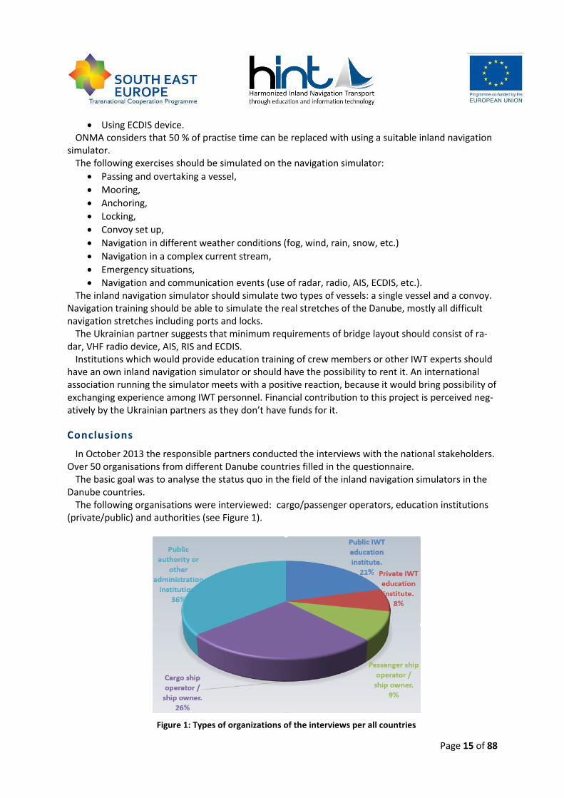
In October 2013 the responsible partners conducted the interviews with the national stakeholders. Over 50 organisations from different Danube countries filled in the questionnaire.
The basic goal was to analyse the status quo in the field of the inland navigation simulators in the Danube countries.
The following organisations were interviewed: cargo/passenger operators, education institutions (private/public) and authorities (see Figure 1).
Figure 1: Types of organizations of the interviews per all countries
Page 16 of 88
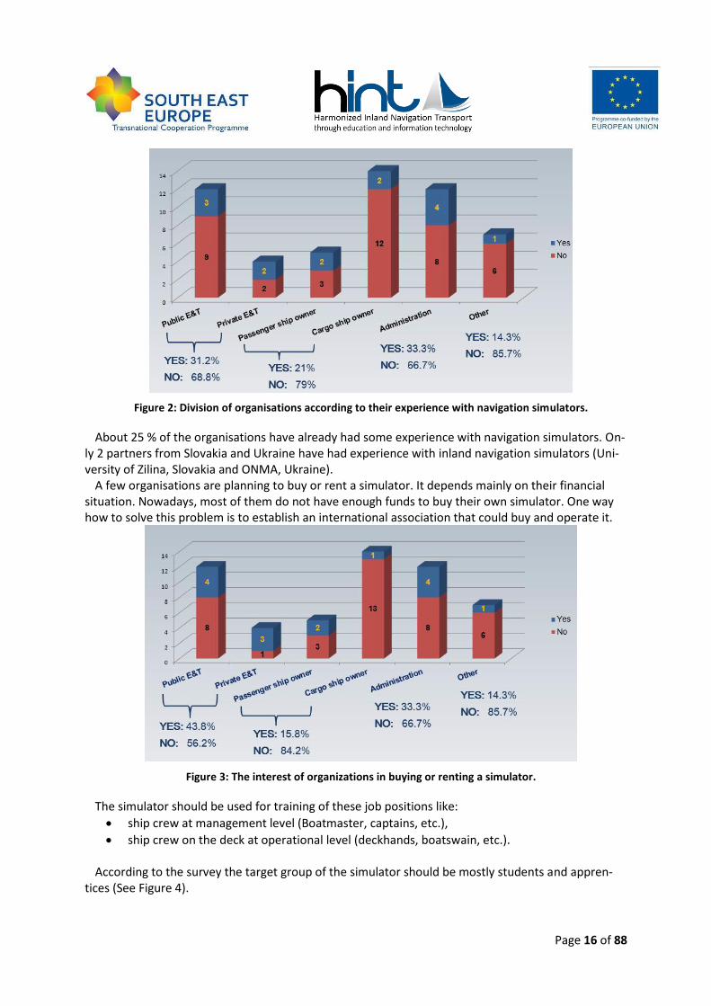
Figure 2: Division of organisations according to their experience with navigation simulators.
About 25 % of the organisations have already had some experience with navigation simulators. On-ly 2 partners from Slovakia and Ukraine have had experience with inland navigation simulators (Uni-versity of Zilina, Slovakia and ONMA, Ukraine).
A few organisations are planning to buy or rent a simulator. It depends mainly on their financial situation. Nowadays, most of them do not have enough funds to buy their own simulator. One way how to solve this problem is to establish an international association that could buy and operate it.
Figure 3: The interest of organizations in buying or renting a simulator.
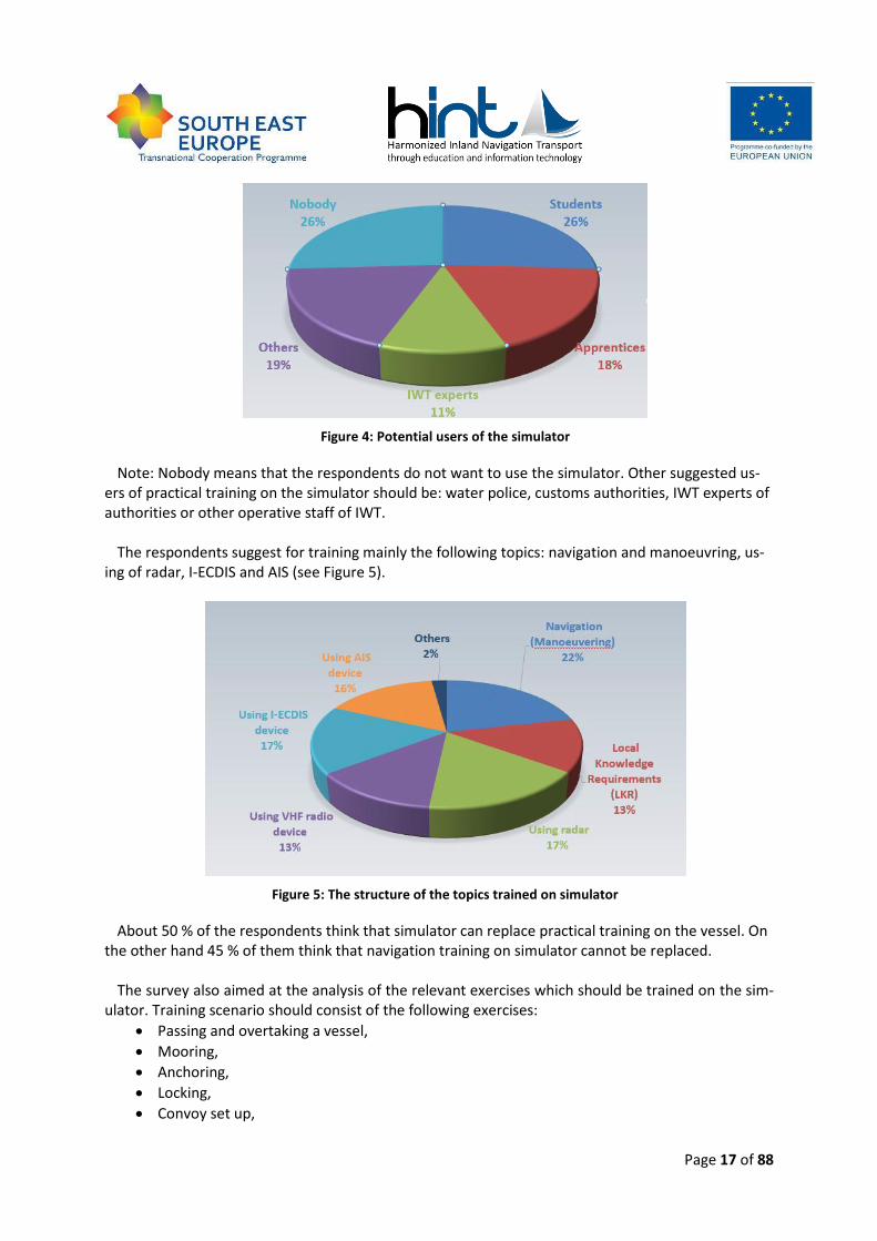
The simulator should be used for training of these job positions like:
ship crew at management level (Boatmaster, captains, etc.),
ship crew on the deck at operational level (deckhands, boatswain, etc.). According to the survey the target group of the simulator should be mostly students and appren-
tices (See Figure 4).
Page 17 of 88
Figure 4: Potential users of the simulator
Note: Nobody means that the respondents do not want to use the simulator. Other suggested us-ers of practical training on the simulator should be: water police, customs authorities, IWT experts of authorities or other operative staff of IWT.
The respondents suggest for training mainly the following topics: navigation and manoeuvring, us-
ing of radar, I-ECDIS and AIS (see Figure 5).
Figure 5: The structure of the topics trained on simulator
About 50 % of the respondents think that simulator can replace practical training on the vessel. On the other hand 45 % of them think that navigation training on simulator cannot be replaced.
The survey also aimed at the analysis of the relevant exercises which should be trained on the sim-
ulator. Training scenario should consist of the following exercises:
Passing and overtaking a vessel,
Mooring,
Anchoring,
Locking,
Convoy set up,
Page 18 of 88
Specific manoeuvres,
Navigation in the different weather conditions (fog, wind, rain, snow, etc.),
Navigation in a complex current stream,
Navigation in channel and in shallow water; grounding and squat,
Emergency situations,
Navigation and communication events (use of radar, radio, AIS, ECDIS, etc.). The most preferred education topic is navigation, but all activities in the wheelhouse should be
trained. Other important topics should be: navigation in different weather conditions and emergency situations. All the respondents consider that not only one type of the vessel should be simulated. They would like to simulate a single vessel and also a convoy.
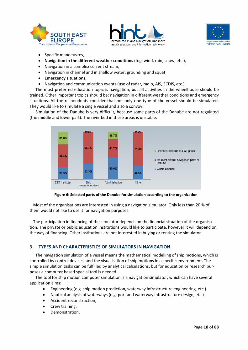
Simulation of the Danube is very difficult, because some parts of the Danube are not regulated (the middle and lower part). The river bed in these areas is unstable.
Figure 6: Selected parts of the Danube for simulation according to the organization
Most of the organisations are interested in using a navigation simulator. Only less than 20 % of them would not like to use it for navigation purposes.
The participation in financing of the simulator depends on the financial situation of the organisa-
tion. The private or public education institutions would like to participate, however it will depend on the way of financing. Other institutions are not interested in buying or renting the simulator.
3 TYPES AND CHARACTERISTICS OF SIMULATORS IN NAVIGATION
The navigation simulation of a vessel means the mathematical modelling of ship motions, which is controlled by control devices, and the visualisation of ship motions in a specific environment. The simple simulation tasks can be fulfilled by analytical calculations, but for education or research pur-poses a computer based special tool is needed.
The tool for ship motion computer simulation is a navigation simulator, which can have several application aims:
Engineering (e.g. ship motion prediction, waterway infrastructure engineering, etc.)
Nautical analysis of waterways (e.g. port and waterway infrastructure design, etc.)
Accident reconstruction,
Crew training,
Demonstration,
Page 19 of 88
Depending on the simulation purposes the computer simulation requires high quality visualisation and/or a very accurate mathematical model, validated by ship and environment tests.
Actually the navigation simulators are built in tailor made or modular configuration, but in the ap-plication they can be classified. The maritime navigation simulators are commonly used in crew train-ing, and they have to be certified for different trainings because of strict education rules. The certifi-cation has to be made by an independent classification institute. For example the Det Norske Veritas (DNV) classification society has standards for certification of maritime simulator systems, which de-fines four simulator classes:
Class Short description
Class A (NAV) A full mission simulator capable of simulating a total shipboard bridge opera-tion situation, including the capability for advanced manoeuvring in restricted waterways.
Class B (NAV) A multi task simulator capable of simulating a total shipboard bridge opera-tion situation, but excluding the capability of advanced manoeuvring in restrict-ed waterways.
Class C (NAV) A limited task simulator capable of simulating a shipboard bridge operation situation for limited (instrumentation or blind) navigation and collision avoid-ance.
Class S (NAV) A special tasks simulator capable of simulating operation and/or maintenance of particular bridge instruments, and/or defined navigation/manoeuvring sce-narios.
Table 1: Simulator classes for the function area bridge operation (DNV)
In inland navigation the application of navigation simulators is not mandatory and common. Due to this fact the process of certification and classification has not been worked out yet. This study sug-gests applying the following inland navigation simulator classes:
Class Name
Class E Exhibition inland navigation simulator
Class D Research inland navigation simulator
Class C Limited task inland navigation simulator
Class B Multi-task inland navigation simulator
Class A Full mission inland navigation simulator
Class AA Full mission inland navigation simulator with maritime character river stretches
Class S Special task inland navigation simulator
Table 2: Inland navigation simulator classes
The following sub chapters will give a short description about the inland navigation simulator clas-ses, but the whole study deals with only the simulators of crew training (C-AA).
Page 20 of 88
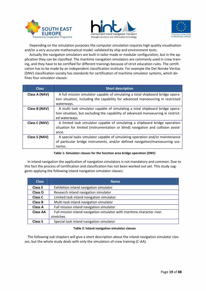
Class E - Exhibit ion inland navigation si mulator
Figure 7: Class E - Exhibition inland navigation simulator example
The primary objective of Class E simulators is the demonstration and arousing an interest in inland navigation. In professional navigation training these simulators can be applied as a debriefing station only.
The target groups are non-professionals and amateur audience, who are curious about inland navi-gation.
The Class E simulators are mobile or stationary systems or units which appearance can be from a personal computer to special user interface developed for demonstration purposes.
The basic controls and signalling devices (rudder angle, engine charge, bow thruster, navigation lights, velocity, water depth, speed, rate of turn, etc.) can be found on the control panel or on the screen. Other devices and switches (e.g., radar, AIS transponder, ECDIS, engine diagnostics tools, etc.) are optional.
Class D - Research inland navigation sim ulator
The primary objective of Class D simulators is to perform research and development tasks. Class D inland navigation simulators can be used in several areas of research and development:
engineering (ships manoeuvrability prediction, waterway infrastructure design, etc.),
waterway nautical analysis,
accident reconstruction,
development of navigation training simulators (e.g., vessel and environment modelling ) .
The target groups are the scientists, nautical experts and engineers, or the administrators and trainers of crew training navigation simulators.
Class D simulators are built with high-performance IT background, which is able to solve complex, compute-intensive mathematical models. The simulator interface and visualization interface evalua-
Page 21 of 88
tion of the research and development duties, flight crew training is only the hydrodynamic back-ground training.
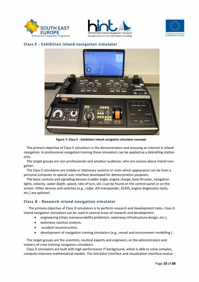
Figure 8: Class D - Research inland navigation simulator example
The control panel and the screen of the simulator serve to evaluation of research and development tasks. For education of navigation personnel the Class D simulators can be applied by demonstration of theoretical background. The control and signalling units of a real wheelhouse are usually not like the real units, because they are just for displaying the different navigation parameters and data. In professional navigation training the Class D simulators can be the instructor stations.
Class C - Limited task inland navigation simul ator
The objective of Class C simulators is the navigation crew training, practice of basic navigation and ship control equipment, or teaching the radar and ECDIS (maybe AIS and VHF radio) based naviga-tion.
The target groups are professional inland navigation crew members, like helmsmen, boatmasters or radar , ECDIS , AIS, VHF radio operators.
The trainings with Class C simulators take several hours, and are aimed to train real navigation mis-sions using only the basic navigational instruments.
The construction of the simulator is stationary, where the control surface can be in range from a common personal computer (monitors, keyboard, mouse, etc.) to a realistic wheelhouse. The basic control and signalling units (which can be found in a real wheelhouse) appear realistic in the simula-tor. The equipment, which is not necessary for the training, is optional. Appearance of the view from the wheelhouse is optional, perspective view is not necessary.
The dynamical models of a vessel and environment are advanced, but some simulation errors are allowed depending on the resolution of the display devices (ECDIS , radar).
Page 22 of 88
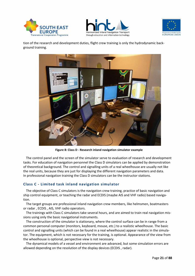
Figure 9: Class C - Limited task inland navigation simulator example
Class C simulators can be used in trainings of machinery crew and other IWT related professionals (engineers, naval architects, ship operators, traffic management, etc.). These trainings aim to famil-iarize the trainees with ship motions and manoeuvring characteristics.
In multi-session mode the Class C simulators are usually workstations beside a full mission simula-tor. But multi-session training with Class C simulator network can be also possible.
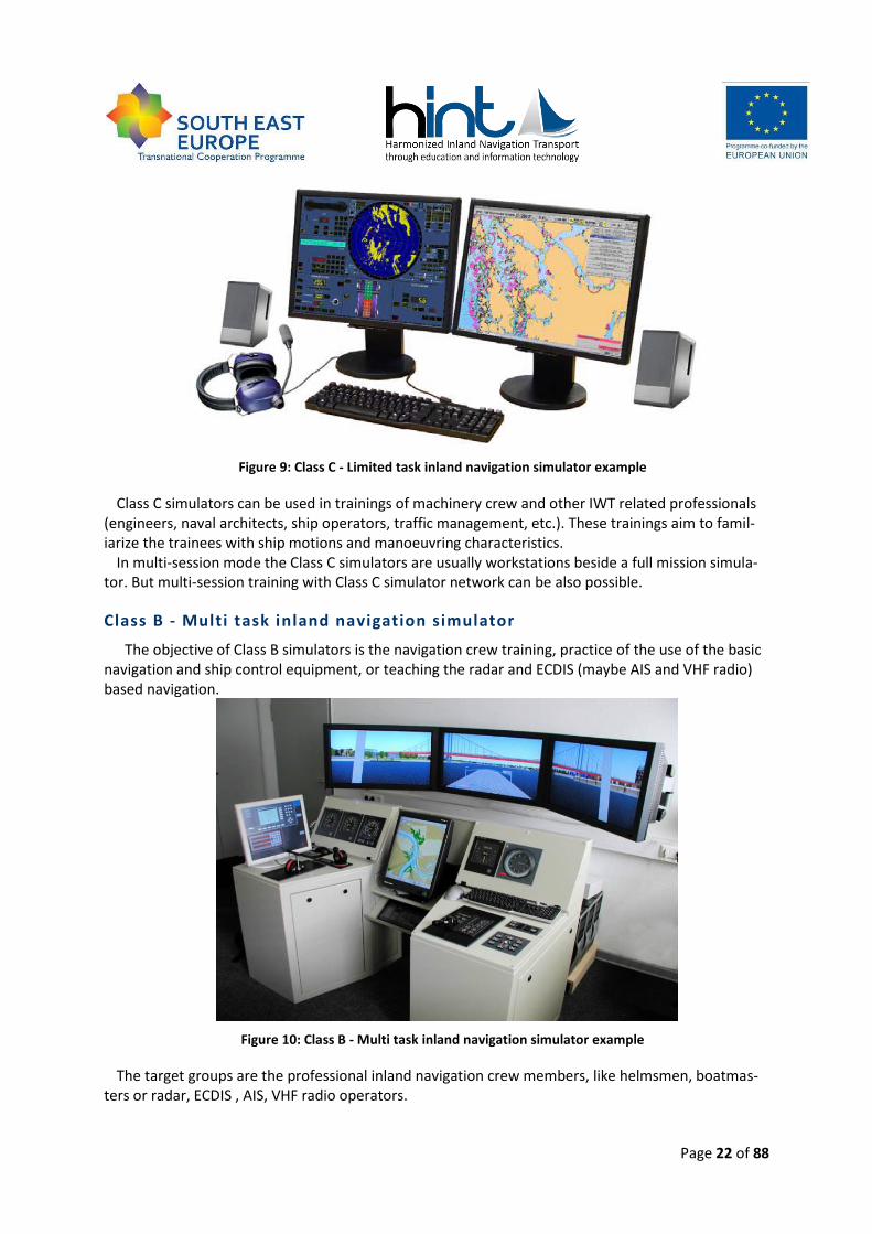
Class B - Multi task inland navigation simulator
The objective of Class B simulators is the navigation crew training, practice of the use of the basic navigation and ship control equipment, or teaching the radar and ECDIS (maybe AIS and VHF radio) based navigation.
Figure 10: Class B - Multi task inland navigation simulator example
The target groups are the professional inland navigation crew members, like helmsmen, boatmas-ters or radar, ECDIS , AIS, VHF radio operators.
Page 23 of 88
The trainings with Class B simulators take several hours, and aim to practise real navigation mis-sions using only basic navigational instruments. Emergency missions can also be practised.
The construction of the simulator is stationary, where the control surface is according to the stand-ards and regulations of wheelhouse equipment, and looks realistic.
The perspective visualisation (monitors or projectors) has at least 90° horizontal field of view and 20° vertical field of view.
The basic control and signalling units (which can be found in a real wheelhouse) appear realistic in the simulator. The equipment, which is not necessary for the training, is optional.
The dynamical models of a vessel and environment are advanced, and the simulation errors are small. The simulated vessels have to fulfil their manoeuvrability standards and requirements (valida-tion is necessary).
The perspective visualisation has to be undistorted in size, distance and shape; only the main ob-jects should be displayed. The water surface is realistic; the nautical and weather conditions can be seen. The visibility is shown according to weather conditions (fog, rain, daylight, night, etc.).
From education point of view the Class B simulators do not give a real wheelhouse feeling, the trainee will always know that it is not reality.
In multi-session mode the Class B simulators can be workstations beside a full mission simulator. But multi-session training with Class B simulator network can also be possible.
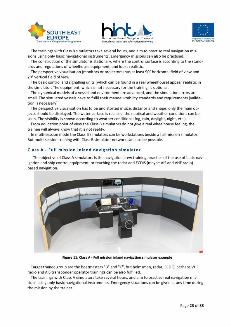
Class A - Full mission inland navigation simulator
The objective of Class A simulators is the navigation crew training, practice of the use of basic nav-igation and ship control equipment, or teaching the radar and ECDIS (maybe AIS and VHF radio) based navigation.
Figure 11: Class A - Full mission inland navigation simulator example
Target trainee group are the boatmasters "B" and "C", but helmsmen, radar, ECDIS, perhaps VHF radio and AIS transponder operator trainings can be also fulfilled.
The trainings with Class A simulators take several hours, and aim to practise real navigation mis-sions using only basic navigational instruments. Emergency situations can be given at any time during the mission by the trainer.
Page 24 of 88
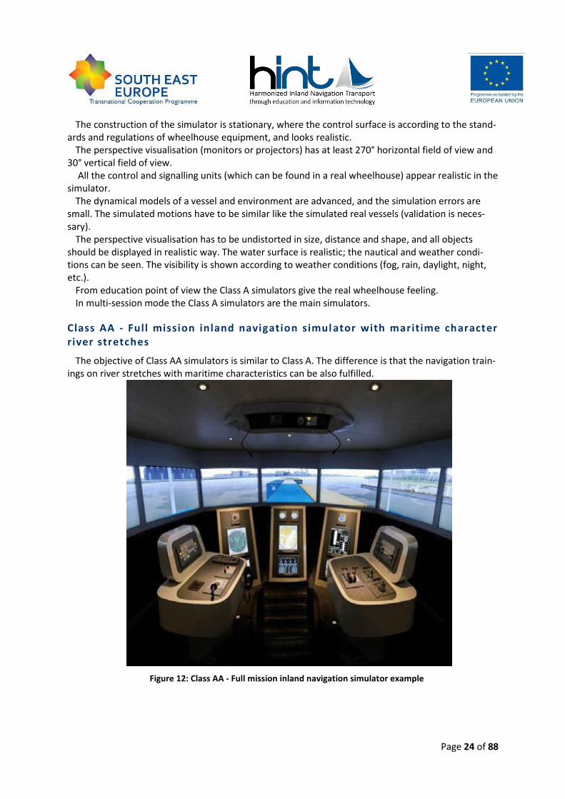
The construction of the simulator is stationary, where the control surface is according to the stand-ards and regulations of wheelhouse equipment, and looks realistic.
The perspective visualisation (monitors or projectors) has at least 270° horizontal field of view and 30° vertical field of view.
All the control and signalling units (which can be found in a real wheelhouse) appear realistic in the simulator.
The dynamical models of a vessel and environment are advanced, and the simulation errors are small. The simulated motions have to be similar like the simulated real vessels (validation is neces-sary).
The perspective visualisation has to be undistorted in size, distance and shape, and all objects should be displayed in realistic way. The water surface is realistic; the nautical and weather condi-tions can be seen. The visibility is shown according to weather conditions (fog, rain, daylight, night, etc.).
From education point of view the Class A simulators give the real wheelhouse feeling. In multi-session mode the Class A simulators are the main simulators.
Class AA - Full mission inland navigation simul ator with maritime character river stretches
The objective of Class AA simulators is similar to Class A. The difference is that the navigation train-ings on river stretches with maritime characteristics can be also fulfilled.
Figure 12: Class AA - Full mission inland navigation simulator example
Page 25 of 88
Target trainee group are all kinds of boatmasters (from A to C), but also helmsmen; radar, ECDIS, perhaps VHF radio and AIS transponder operator trainings can be included.
The difference between A and AA class in construction means more developed environment in dy-namical model and the vessel dynamical model is more accurate in pitch, yaw and heave motions.
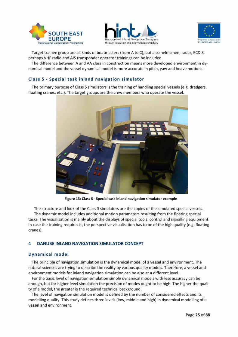
Class S - Special task inland navigation simulator
The primary purpose of Class S simulators is the training of handling special vessels (e.g. dredgers, floating cranes, etc.). The target groups are the crew members who operate the vessel.
Figure 13: Class S - Special task inland navigation simulator example
The structure and look of the Class S simulators are the copies of the simulated special vessels. The dynamic model includes additional motion parameters resulting from the floating special
tasks. The visualisation is mainly about the displays of special tools, control and signalling equipment. In case the training requires it, the perspective visualisation has to be of the high quality (e.g. floating cranes).
4 DANUBE INLAND NAVIGATION SIMULATOR CONCEPT
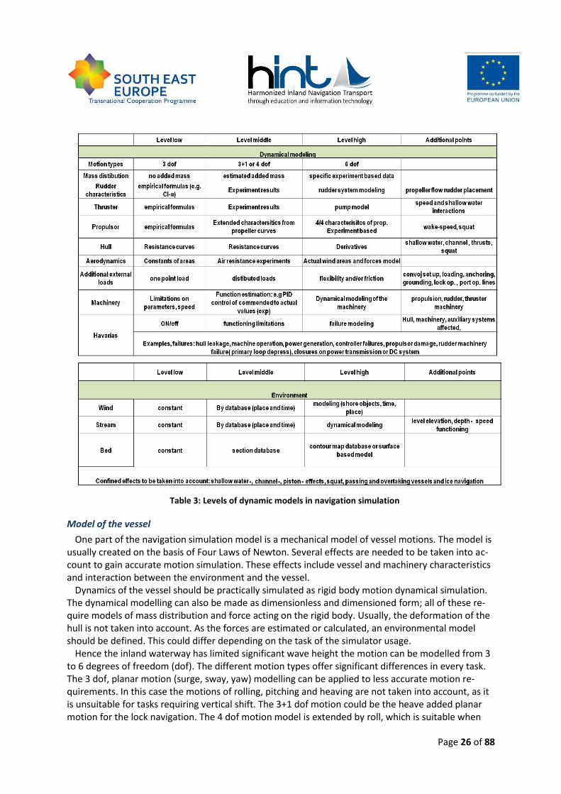
Dynamical model
The principle of navigation simulation is the dynamical model of a vessel and environment. The natural sciences are trying to describe the reality by various quality models. Therefore, a vessel and environment models for inland navigation simulation can be also at a different level.
For the basic level of navigation simulation simple dynamical models with less accuracy can be enough, but for higher level simulation the precision of modes ought to be high. The higher the quali-ty of a model, the greater is the required technical background.
The level of navigation simulation model is defined by the number of considered effects and its modelling quality. This study defines three levels (low, middle and high) in dynamical modelling of a vessel and environment.
Page 26 of 88
Table 3: Levels of dynamic models in navigation simulation
Model of the vessel
One part of the navigation simulation model is a mechanical model of vessel motions. The model is usually created on the basis of Four Laws of Newton. Several effects are needed to be taken into ac-count to gain accurate motion simulation. These effects include vessel and machinery characteristics and interaction between the environment and the vessel.
Dynamics of the vessel should be practically simulated as rigid body motion dynamical simulation. The dynamical modelling can also be made as dimensionless and dimensioned form; all of these re-quire models of mass distribution and force acting on the rigid body. Usually, the deformation of the hull is not taken into account. As the forces are estimated or calculated, an environmental model should be defined. This could differ depending on the task of the simulator usage.
Hence the inland waterway has limited significant wave height the motion can be modelled from 3 to 6 degrees of freedom (dof). The different motion types offer significant differences in every task. The 3 dof, planar motion (surge, sway, yaw) modelling can be applied to less accurate motion re-quirements. In this case the motions of rolling, pitching and heaving are not taken into account, as it is unsuitable for tasks requiring vertical shift. The 3+1 dof motion could be the heave added planar motion for the lock navigation. The 4 dof motion model is extended by roll, which is suitable when
Page 27 of 88
bending moments are acting with great performance on the task. The 6 dof dynamical model is the general adaptation where all of the motion types (surge, sway, heave, roll, pitch, yaw) of the rigid body are computed.
The mass distribution of the vessel is set up on the basis of vessel drawings. Different loading conditions of the ship means different mass distribution and inertia matrices. Another effect is the mass of the water attached to the hull. For gaining reasonable results of the vessel behaviour, each motion type and forces combination offer different mass on different derivatives of motion types. Of course, various models can be used, from general empirical formulas to experiments of specific ves-sels inertia matrices.
As the dynamical model is applied, the forces acting on the rigid body are to be calculated no mat-ter if on a non-dimensional form or not. The main forces to compute are the so-called rudder, pro-peller, thruster and hull forces, with more additional ones. The loads acting on the rudder system could be computed in several ways based on the available information about the vessel and its trials or towing tank experiments. From empirical formulas of wing profile forces to specific rudder exper-iments can be used. The more complex system is implemented with experiment result the more ac-curate estimation of behaviour is made. The small and full scale tests or CFD calculations can be the basis of accurate estimation. The propeller behaviour can also be estimated in various forms. The adaptation depends on precision of estimation of thrust modelling. The wake fraction and thrust de-duction should be estimated as a function of propulsion loading and the speed of the vessel too for gaining more accurate movement. The translational and rotational speeds are required to be taken into account for all kinds of simulations except for some of presentation categories.
Thruster as bow or stern jet is required to be modelled for the vessels which have these kinds of rudder or propulsion. The two main types of them as a jet thruster or a tunnel thruster are practically modelled in the different way, as the effect of thrust generation by speed of a vessel and available thrust direction differ. The shallow water is to be considered for manoeuvring tasks. The thruster can be modelled combined to its machinery, but in this case exact specific experiment results validation is required. Also the modelling could be made on the basis of diverse experiment results with more accurate pump model of them.
The hydrodynamic forces acting on the vessels hull are of the great importance regarding behav-iour analysis. These can be modelled from estimated resistance curves along exact validation of spe-cific ones. The model could be made on the basis of resistance type separation or on the mathemati-cal approach of derivatives of speed and acceleration components and more. The complex validation of the different effects is required for higher level purposes, such as transversal resistance and drift along trial manoeuvres at least. Specific effects are to be considered like squat (draft increase of the vessel caused by water speed change around the vessel), shallow water and channel effect on con-fined waterway, interaction between the propeller and the thruster (e.g. wake fraction change and water flow speed up).
Aerodynamic forces are also to be considered as acting on the centre of the transversal and hori-zontal plane. The actual wind speed on a body coordinate system is to be computed on the basis of the air speed development which is described below in the chapter of environmental modelling. Dur-ing the simulation the motion of the rigid body model vessel causes the lateral and transversal wind areas change, which can be taken into account in the modelling. Accurate simulation could be based on small-scale model tests at a wind tunnel.
Additional forces, as rope loads on a port, loading, anchoring, convoy setup, and grounding can al-so be modelled at a different level of complexity depending on the actual task. The forces could be set as individual ones with a single point or distributed load transmission. To gain the most complex but practical solution, structural flexibility and friction between bodies are to be modelled.
Page 28 of 88
Machinery behaviour is also important to the model; because of this there are the interacting sys-tems between the ship handler and the behaviour of the vessel. All of the propulsion, the rudder and the thruster machinery are significant, but in the different complexity. The behaviour of the propul-sion system, for example, could be integrated into one model with its machinery, as thrust generat-ing is a function of an actual state and commended values. In this example the PID (proportional – integral – derivative gain approach) control concept is used on many general ship motion models. After a validation process the results can be accurate enough for simpler purposes. If the machineries are modelled the behaviour of them could be more precise, and the nature of the occurring failure could be investigated.
Possibility of an accident on board could also lead simulator based training. Several types of acci-dents: hull, machinery, mechanical and auxiliary systems are to be considered, depending on the ex-act task and requirements of the educator. For example the propulsor machine operation, the auxil-iary electrical system closure, the hull leakage, and the failure of the controller arm could also be im-portant. Serious accidents could be simulated by several ways. Of course the simplest way of simula-tion is to turn 'off' on the control input. Operation limitation change also leads to a kind of accident modelling. The most accurate and flexible system could be used when the accident and its effect to every part of simulation is to be modelled simultaneously with machinery and dynamical modelling. In specific cases independent model of the accident could be available on operation of the simulator. The accuracy of the accident is hardly to be validated as well; however some of its effects could be estimated easily.
To summarize the findings, the behaviour of the vessel (in every motion type of itself) requires validation for at least the listed effects if the simulator is to be used as navigation education equip-ment. For presentation tasks many simplifications can be acceptable. The validation requirements are changing by the task and function of the simulator (e.g. for Local Knowledge Requirement educa-tion, more accurate model can be validated, than for the radar navigation procedure education tasks).
Model of the environment
The environment of the simulation area makes the surroundings of the force and mass computa-tion since these are the functions of the actual position and speed of the vessel and the environment parameters. Wind and current speed, actual river bed draught and different streams significantly af-fect the behaviour of functions and of course the vessels motions. The main environmental parame-ters to be computed for each point of itself are: wind speed and direction (for inland navigation the horizontal variability modelling is unnecessary), the current speed and direction with the effect of every vortices and streams and of course the river bed as constrain of a navigable area and an input parameter of stream speed and shallow water resistance computation. As the environment can be taken into account as a point of variable and distribution around the hull, the modelling techniques can be different for different tasks. The wind effect simulation is based on the simulation of the wind itself. The wind can be taken into account with constant speed and direction or with a time domain wind speed and direction simulation. The time domain wind simulation can be based on meteorolog-ical databases and/or on difficult mathematical simulations
Current and stream can be set as a constant value alongside the whole area or in every section a constant stream can be taken into account. We can say that in this case the movement of the vessel could not be realistic because of the effect of the vortices and side streams. A higher level of model-ling can be based on measurements of the stream in sections. In amongst the sections the stream is to be interpolated. This case can be precise enough for our tasks. More accurate results can be made if a validated meteorological model is connected to the simulation. It has to be noted that the water level elevation on flood or wane is to be taken into account for education purposes.
Page 29 of 88
The information about the environment is based on the geometry of the bed on one hand. The ba-thymetry of the river is on one hand about the grounding calculation and on the other hand the river current estimation and on the way of confined water effects of the vessels motion (resistance and manoeuvrability). The bed depth information, as the current, depends on the water level (the gauges measurements). The bed information when it is set as a constant value is only able for the presenta-tional simulators, but when sectional measurement dataset is defined (with interpolation between) the data can be validated for the general education purposes of the inland navigational simulator. The contour map database and surface model based on the environment would be accurate enough for validation. The modelling of the bed change and the bathymetry itself is available when the simu-lator is connected to the specific meteorology simulation centre.
In overall the database of the navigation area (not only the waterway but the river itself in lower precision) is required for education tasks for the Danube navigational simulator.
Ship types
The simulated ship type is one of the most important questions by the Danube Navigation Simula-tor. While well defined vessel types can be simulated in Western European united waterways, the ships on the Danube are very different in size or even in functionality. Because of this fact only gen-eral ship types and special vessels can be defined for navigation simulation in the Danube Navigation Simulator. Of course, the navigation simulator in the Danube region should not (cannot) contain the model for the below listed ship types, but vessels of these types are needed to be simulated accord-ing to the goals of simulator training.
General ship types to be simulated
In the Danube Navigation Simulator the pre-defined vessel types must be in accordance with the types mostly used on the Danube. However, there are other obvious factors that determine the simulated vessel’s motions; these are the following:
size (length and breadth);
draft (loaded or unloaded, for cargo vessels);
propulsion type;
rudder system;
convoy size (number of barges, in case of a pusher or a self-propelled vessel);
convoy formation (upstream or downstream) To determine a proper set of vessels in the simulator, all the above are taken into account and
shown in the next table. The following considerations were also applied. It is obvious that the vessel types gained by the combination of the above factors are not equally
important and hence, when considering the development of a new simulator, the most widely used types should be modelled as the first. According to our opinion, the self-propelled cargo and passen-ger vessels and the pushed convoys are the most important options to be modelled as the first.
Each option of the cargo vessels needs a unique definition in the mathematical modelling. If a self-propelled vessel is working as a pusher, it sails with one barge in most of the cases. For this couple, upstream formation means that a barge is in front of the pusher vessel, while in downstream, the barge is at side. With regard to pushed convoys using a push-boat the barges are arranged according to the general handling practice.
For passenger and service vessels draft does not change significantly and formation is not applica-
ble. Fast ships are capable to sail over 40km/h. POD propulsion means that the vessel has azipod thrusters which serve as an active rudder system giving much better manoeuvrability.
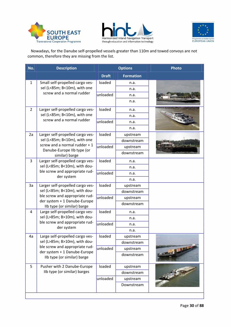
Page 30 of 88
Nowadays, for the Danube self-propelled vessels greater than 110m and towed convoys are not common, therefore they are missing from the list.
No. Description Options Photo
Draft Formation
1 Small self-propelled cargo ves-sel (L<85m; B<10m), with one
screw and a normal rudder
loaded n.a.
n.a.
unloaded n.a.
n.a.
2 Larger self-propelled cargo ves-sel (L<85m; B<10m), with one
screw and a normal rudder
loaded n.a.
n.a.
unloaded n.a.
n.a.
2a Larger self-propelled cargo ves-sel (L<85m; B<10m), with one screw and a normal rudder + 1
Danube-Europe IIb type (or similar) barge
loaded upstream
downstream
unloaded upstream
downstream
3 Larger self-propelled cargo ves-sel (L<85m; B<10m), with dou-ble screw and appropriate rud-
der system
loaded n.a.
n.a.
unloaded n.a.
n.a.
3a Larger self-propelled cargo ves-sel (L<85m; B<10m), with dou-ble screw and appropriate rud-der system + 1 Danube-Europe
IIb type (or similar) barge
loaded upstream
downstream
unloaded upstream
downstream
4 Large self-propelled cargo ves-sel (L>85m; B>10m), with dou-ble screw and appropriate rud-
der system
loaded n.a.
n.a.
unloaded n.a.
n.a.
4a Large self-propelled cargo ves-sel (L>85m; B>10m), with dou-ble screw and appropriate rud-der system + 1 Danube-Europe
IIb type (or similar) barge
loaded upstream
downstream
unloaded upstream
downstream
5 Pusher with 2 Danube-Europe IIb type (or similar) barges
loaded upstream
downstream
unloaded upstream
Downstream
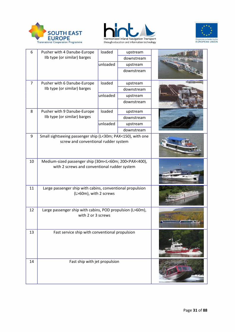
Page 31 of 88
6 Pusher with 4 Danube-Europe IIb type (or similar) barges
loaded upstream
downstream
unloaded upstream
downstream
7 Pusher with 6 Danube-Europe IIb type (or similar) barges
loaded upstream
downstream
unloaded upstream
downstream
8 Pusher with 9 Danube-Europe IIb type (or similar) barges
loaded upstream
downstream
unloaded upstream
downstream
9 Small sightseeing passenger ship (L<30m; PAX<150), with one screw and conventional rudder system
10 Medium-sized passenger ship (30m<L<60m; 200<PAX<400), with 2 screws and conventional rudder system
11 Large passenger ship with cabins, conventional propulsion (L>60m), with 2 screws
12 Large passenger ship with cabins, POD propulsion (L>60m), with 2 or 3 screws
13 Fast service ship with conventional propulsion
14 Fast ship with jet propulsion
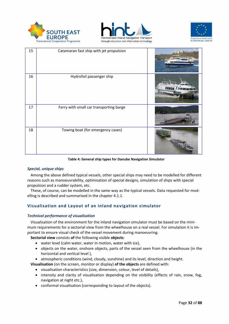
Page 32 of 88
15 Catamaran fast ship with jet propulsion
16 Hydrofoil passenger ship
17 Ferry with small car transporting barge
18 Towing boat (for emergency cases)
Table 4: General ship types for Danube Navigation Simulator
Special, unique ships
Among the above defined typical vessels, other special ships may need to be modelled for different reasons such as manoeuvrability, optimisation of special designs, simulation of ships with special propulsion and a rudder system, etc.
These, of course, can be modelled in the same way as the typical vessels. Data requested for mod-elling is described and summarised in the chapter 4.1.1.
Visualisation and Layout of an inland na vigation simulator
Technical performance of visualisation
Visualisation of the environment for the inland navigation simulator must be based on the mini-mum requirements for a sectorial view from the wheelhouse on a real vessel. For simulation it is im-portant to ensure visual check of the vessel movement during manoeuvring.
Sectorial view consists of the following visible objects:
water level (calm water, water in motion, water with ice),
objects on the water, onshore objects, parts of the vessel seen from the wheelhouse (in the horizontal and vertical level ),
atmospheric conditions (wind, cloudy, sunshine) and its level, direction and height. Visualisation (on the screen, monitor or display) of the objects are defined with:
visualisation characteristics (size, dimension, colour, level of details),
intensity and clarity of visualisation depending on the visibility (effects of rain, snow, fog, navigation at night etc.),
conformal visualisation (corresponding to layout of the objects).
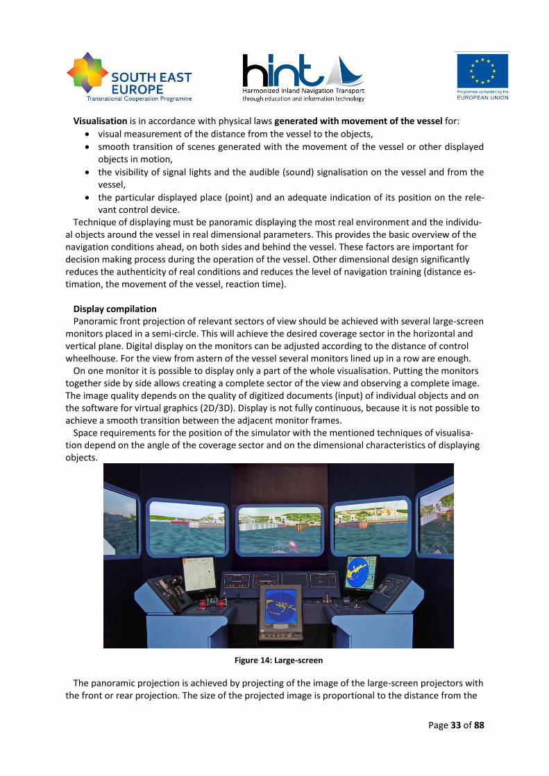
Page 33 of 88
Visualisation is in accordance with physical laws generated with movement of the vessel for:
visual measurement of the distance from the vessel to the objects,
smooth transition of scenes generated with the movement of the vessel or other displayed objects in motion,
the visibility of signal lights and the audible (sound) signalisation on the vessel and from the vessel,
the particular displayed place (point) and an adequate indication of its position on the rele-vant control device.
Technique of displaying must be panoramic displaying the most real environment and the individu-al objects around the vessel in real dimensional parameters. This provides the basic overview of the navigation conditions ahead, on both sides and behind the vessel. These factors are important for decision making process during the operation of the vessel. Other dimensional design significantly reduces the authenticity of real conditions and reduces the level of navigation training (distance es-timation, the movement of the vessel, reaction time).
Display compilation Panoramic front projection of relevant sectors of view should be achieved with several large-screen
monitors placed in a semi-circle. This will achieve the desired coverage sector in the horizontal and vertical plane. Digital display on the monitors can be adjusted according to the distance of control wheelhouse. For the view from astern of the vessel several monitors lined up in a row are enough.
On one monitor it is possible to display only a part of the whole visualisation. Putting the monitors together side by side allows creating a complete sector of the view and observing a complete image. The image quality depends on the quality of digitized documents (input) of individual objects and on the software for virtual graphics (2D/3D). Display is not fully continuous, because it is not possible to achieve a smooth transition between the adjacent monitor frames.
Space requirements for the position of the simulator with the mentioned techniques of visualisa-tion depend on the angle of the coverage sector and on the dimensional characteristics of displaying objects.
Figure 14: Large-screen
The panoramic projection is achieved by projecting of the image of the large-screen projectors with the front or rear projection. The size of the projected image is proportional to the distance from the
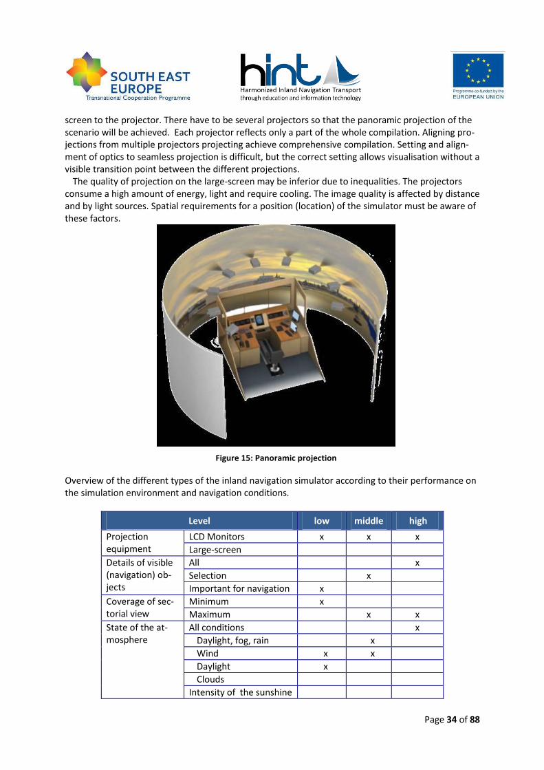
Page 34 of 88
screen to the projector. There have to be several projectors so that the panoramic projection of the scenario will be achieved. Each projector reflects only a part of the whole compilation. Aligning pro-jections from multiple projectors projecting achieve comprehensive compilation. Setting and align-ment of optics to seamless projection is difficult, but the correct setting allows visualisation without a visible transition point between the different projections.
The quality of projection on the large-screen may be inferior due to inequalities. The projectors consume a high amount of energy, light and require cooling. The image quality is affected by distance and by light sources. Spatial requirements for a position (location) of the simulator must be aware of these factors.
Figure 15: Panoramic projection
Overview of the different types of the inland navigation simulator according to their performance on the simulation environment and navigation conditions.
Level low middle high
Projection equipment
LCD Monitors x x x
Large-screen
Details of visible (navigation) ob-jects
All x
Selection x
Important for navigation x
Coverage of sec-torial view
Minimum x
Maximum x x
State of the at-mosphere
All conditions x
Daylight, fog, rain x
Wind x x
Daylight x
Clouds
Intensity of the sunshine
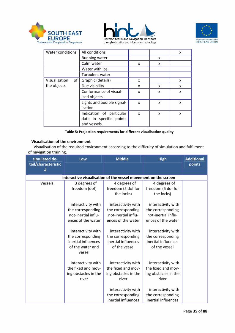
Page 35 of 88
Water conditions All conditions x
Running water x
Calm water x x
Water with ice
Turbulent water
Visualisation of the objects
Graphic (details) x x
Due visibility x x x
Conformance of visual-ised objects
x x x
Lights and audible signal-isation
x x x
Indication of particular data in specific points and vessels.
x x x
Table 5: Projection requirements for different visualisation quality
Visualisation of the environment Visualisation of the required environment according to the difficulty of simulation and fulfilment
of navigation training.
simulated de-tail/characteristic
↓
Low Middle High Additional points
interactive visualisation of the vessel movement on the screen
Vessels 3 degrees of freedom (dof)
interactivity with the corresponding not-inertial influ-
ences of the water
interactivity with the corresponding inertial influences of the water and
vessel
interactivity with the fixed and mov-ing obstacles in the
river
4 degrees of freedom (5 dof for
the locks)
interactivity with the corresponding not-inertial influ-
ences of the water
interactivity with the corresponding inertial influences
of the vessel
interactivity with the fixed and mov-ing obstacles in the
river
interactivity with the corresponding inertial influences
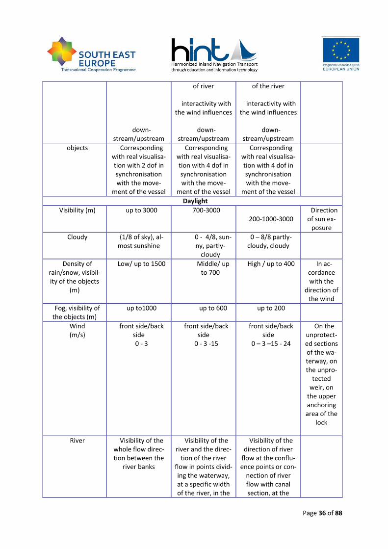
Page 36 of 88
down-stream/upstream
of river
interactivity with the wind influences
down-
stream/upstream
of the river
interactivity with the wind influences
down-
stream/upstream
objects Corresponding with real visualisa-tion with 2 dof in synchronisation with the move-
ment of the vessel
Corresponding with real visualisa-tion with 4 dof in synchronisation with the move-
ment of the vessel
Corresponding with real visualisa-tion with 4 dof in synchronisation with the move-
ment of the vessel
Daylight
Visibility (m) up to 3000 700-3000 200-1000-3000
Direction of sun ex-
posure
Cloudy (1/8 of sky), al-most sunshine
0 - 4/8, sun-ny, partly-
cloudy
0 – 8/8 partly-cloudy, cloudy
Density of rain/snow, visibil-ity of the objects
(m)
Low/ up to 1500 Middle/ up to 700
High / up to 400 In ac-cordance with the
direction of the wind
Fog, visibility of the objects (m)
up to1000 up to 600 up to 200
Wind (m/s)
front side/back side 0 - 3
front side/back side
0 - 3 -15
front side/back side
0 – 3 –15 - 24
On the unprotect-ed sections of the wa-terway, on the unpro-
tected weir, on
the upper anchoring area of the
lock
River Visibility of the whole flow direc-tion between the
river banks
Visibility of the river and the direc-
tion of the river flow in points divid-ing the waterway, at a specific width of the river, in the
Visibility of the direction of river
flow at the conflu-ence points or con-
nection of river flow with canal section, at the
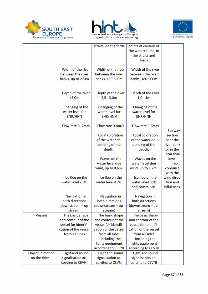
Page 37 of 88
Width of the river between the river banks, up to 270m
Depth of the river >3,0m
Changing of the water level for
ENR/HNN
Flow rate 0- 2m/s
Ice floe on the water level 25%.
Navigation in both directions
(downstream – up-stream)
straits, on the fords
Width of the river between the river banks, 150-600m
Depth of the river 2,5 - 3,0m
Changing of the water level for
ENR/HNN
Flow rate 0-4m/s
Local coloration of the water de-pending of the
depth.
Waves on the water level due
wind, up to 0,6m.
Ice floe on the water level 45%.
Navigation in both directions
(downstream – up-stream)
points of division of the watercourse, in
the straits and fords
Width of the river
between the river banks, 180-900m
Depth of the river 1,9 - 4m
Changing of the water level for
ENR/HNN
Flow rate 0-6m/s
Local coloration of the water de-pending of the
depth.
Waves on the water level due
wind, up to 1,2m.
Ice floe on the water level 60% and coastal ice.
Navigation in
both directions (downstream – up-
stream)
Fairway section
near the river bank or in the
local shal-lows. In ac-
cordance with the
wind direc-tion and
influences.
Vessels The basic shape and contour of the vessel for identifi-
cation of the vessel from all sides
The basic shape and contour of the vessel for identifi-
cation of the vessel from all sides including the
lights equipment according to CEVNI
The basic shape and contour of the vessel for identifi-
cation of the vessel from all sides including the
lights equipment according to CEVNI
Object in motion on the river
Light and sound signalisation ac-cording to CEVNI
Light and sound signalisation ac-cording to CEVNI
Light and sound signalisation ac-cording to CEVNI
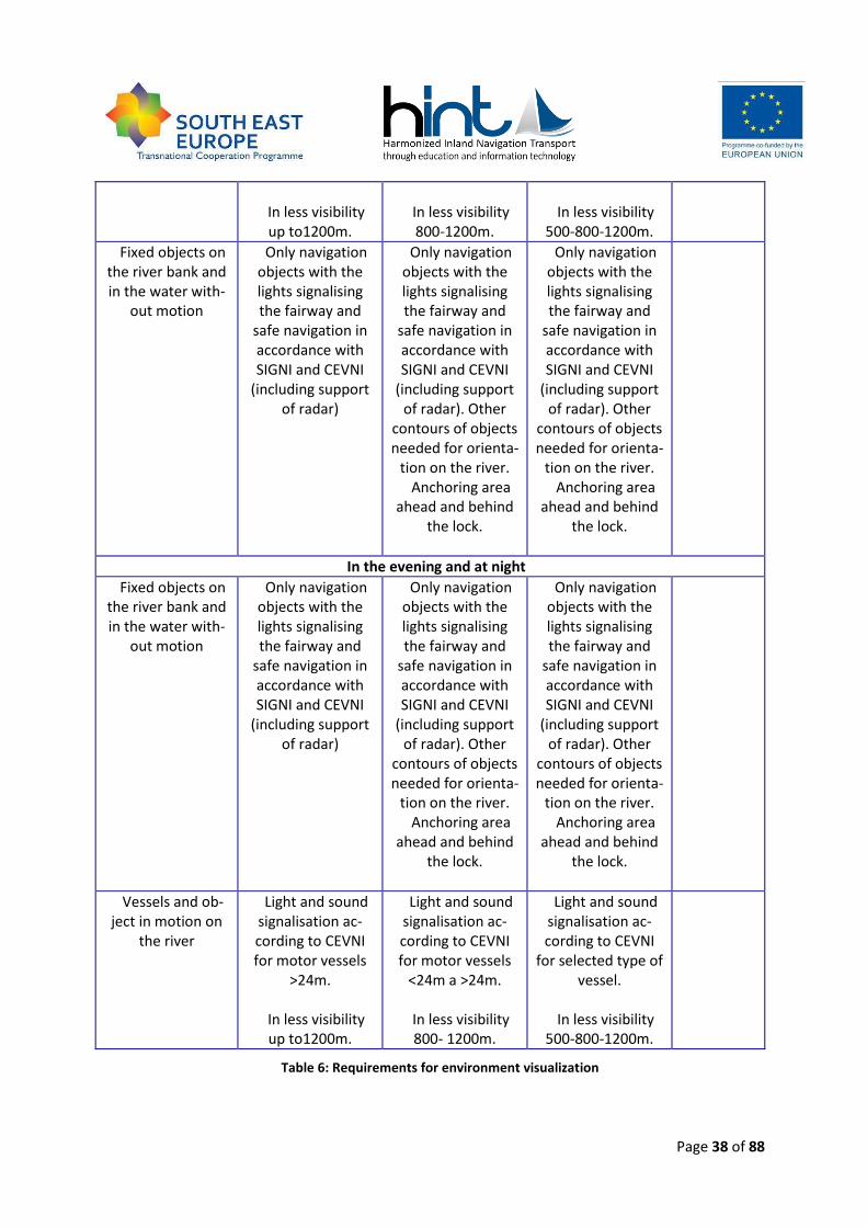
Page 38 of 88
In less visibility up to1200m.
In less visibility 800-1200m.
In less visibility
500-800-1200m.
Fixed objects on the river bank and in the water with-
out motion
Only navigation objects with the lights signalising the fairway and
safe navigation in accordance with SIGNI and CEVNI
(including support of radar)
Only navigation objects with the lights signalising the fairway and
safe navigation in accordance with SIGNI and CEVNI
(including support of radar). Other
contours of objects needed for orienta-
tion on the river. Anchoring area
ahead and behind the lock.
Only navigation objects with the lights signalising the fairway and
safe navigation in accordance with SIGNI and CEVNI
(including support of radar). Other
contours of objects needed for orienta-
tion on the river. Anchoring area
ahead and behind the lock.
In the evening and at night
Fixed objects on the river bank and in the water with-
out motion
Only navigation objects with the lights signalising the fairway and
safe navigation in accordance with SIGNI and CEVNI
(including support of radar)
Only navigation objects with the lights signalising the fairway and
safe navigation in accordance with SIGNI and CEVNI
(including support of radar). Other
contours of objects needed for orienta-
tion on the river. Anchoring area
ahead and behind the lock.
Only navigation objects with the lights signalising the fairway and
safe navigation in accordance with SIGNI and CEVNI
(including support of radar). Other
contours of objects needed for orienta-
tion on the river. Anchoring area
ahead and behind the lock.
Vessels and ob-ject in motion on
the river
Light and sound signalisation ac-cording to CEVNI for motor vessels
>24m.
In less visibility up to1200m.
Light and sound signalisation ac-cording to CEVNI for motor vessels
<24m a >24m.
In less visibility 800- 1200m.
Light and sound signalisation ac-cording to CEVNI
for selected type of vessel.
In less visibility
500-800-1200m.
Table 6: Requirements for environment visualization
Page 39 of 88
Layout of the wheelhouse
Managing workplace of the inland vessel is a wheelhouse and an engine room. For the Danube Navigation Simulator is necessary to simulate the vessel from the wheelhouse. The wheelhouse con-tains navigation and communication technologies. From the wheelhouse is managed the movement of the vessel and other important technical facilities in order to ensure navigational safety. Part of the wheelhouse is also the control panel indicating the functionality of all important navigation equipment. Spatial arrangement of the wheelhouse, navigation equipment and their location is ac-cording to:
EU Directive 87/2006
European Commission Decision 61/2006 for EU (ECE/TRANS/SC/.3/172)
Danube Commission document published in 2007 (DC/CEC 68/7). Layout of the wheelhouse, instruments, consoles, communication equipment and other indicators
must be in accordance with these regulations. Visualisation of the environment from the wheelhouse should cover the minimum or maximum angular sectors ahead of the vessel and behind the vessel. The wheelhouse design should be similar to the current level of processing and production in the shipyard. Navigation devices and equipment in the wheelhouse must be on the same level of per-formance as on the real vessel. Following the design of the navigation equipment of the wheelhouse to the real vessel (size, layout of the maquettes) it is possible to achieve the consistency with real conditions. Lighting conditions in the wheelhouse should be modifiable. Navigation instruments shall permit regulation of the backlight of the data’s, scales, screens etc. to prevent blinding by the man-agement of the vessel. The wheelhouse should be an independent room. Acoustic spectrum of nauti-cal communication VHF should be the same as on the real river with participation of other vessels.
Level low middle high
Visualisation of the specific
data on the navigation de-
vices.
Echo sounder x x x
Rate of turn x x x
AIS – data from the vessel, speed, course, data from other vessels
x x
I-ECDIS – visualisation of a particular river section, iso-baths for each water condi-tions, position of the vessel, history of navigation itiner-ary, real route of the vessel, route planning.
x
Full functionally river radar including corresponding radar displaying the posi-tion of an individual point or the vessel.
x x
Radar + I-ECDIS x
Table 7: Visualization of the specific data on the navigation devices
Page 40 of 88
Navigation environment on Danube and Local Knowledge Requir ements
Local knowledge requirements
Country waterway List of difficult stretches (rkm-rkm)
Principal difficult conditions
Germany E80 from Straubing to Vilshofen
low fairway depth (1,55 m)
Austria E80 2038,0- 2008,0 1938,0-1873,0
At the low water levels, shallow water with depth of ≤ 2,20m; straits with width 90÷100m with the flow rate up to 9m/s.
Slovakia E80 Waterworks Gabcikovo
Lock of Gabcikovo
1810,0 -1708,2
Unprotected open water area with a length of 13km with gusty wind up to 9m/s, wave high up to 1m. Canal sec-tion of width 100÷200m in length of 38km. Particular stretch freezes in the winter. Double single-stage lock 275x33m. Monitored and controlled operation of vessels. On the upper section of the lock gusty front-side and back-side wind occurs. In winter an ice could oc-cur in the locks. At the low water levels occurs shallows with depth 1,9÷2,5 m and straits with width 60 ÷ 120m.
Hungary E80 Joint Slovak - Hun-garian section 1810 - 1708,2
1708,2 - 1652
Low maximum draught at dry seasons (1,70 m) and height under bridges: road bridge Medved’ov (1806,35 km) 8,85 m; railway bridge Komarno (1770,4 km) 8,10-8,15 m; road bridge Komarno (1767,8 km) 7,75 m, low maximum draught (1,50 - 1,70 m) and height under the railway bridge Ujpest (1654,5 km) – 7,66m.
Croatia E80 No bottlenecks on the Danube.
Serbia E80 863 - 845,5 low fairway depth at dry seasons with fairway depth limited to 2,20-2,30 m for 7-15 days a year
Bulgaria E80
Island Milka
Information from Silistra (374,1 km) to Somovit (610km) Summer problems: Low water levels, shallow water with
Page 41 of 88
(572-568) Island Belene
(564-560)
386 - 382 395 - 390 401 - 398 408 - 404 415 - 412 424 - 420 428 - 425 441 - 436 458 - 455 463 - 460 476 - 472 489 - 485 507 - 504 513 - 510 518 - 514 522 - 520 525 - 522 537 - 534 541 - 537 544 - 541 567 - 564 569 - 567 576 - 573 586 - 584 591 - 589 610 – 608
depth - 1,60 m and width - 180 m. Low water levels, shallow water with depth - 2,20m and width - 180 m. Low water levels shallow water with depth of ≤ 2,50m and or width – 180 m. Winter problems: Floating ice and full stretch freezes in winter. Common problem: Lack of the traverses and locks on the river. We have no information from km 802 to km 610.
Romania E80 863 - 175
863 - 845,5 845,5 - 610 610 - 375
375 - 300
300 - 175
170 - the Black Sea, i.e. at 73, 57,47, 41
and 37 nautical miles and on the Sulina arm at the
mouth of the Sulina Canal where it
low fairway depth at dry seasons at several critical sections with fairway depth limited to 2,20-2,30 m for 7-15 days a year with fairway depth limited to 2,10-2,20 m for 10-15 days a year with fairway depth limited to 1,80-2,00 m for 20-40 days a year with fairway depth limited to 1,60-2,20 m for 30-70 days a year with fairway depth limited to 1,90-2,10 m for 15-30 days a year low fairway depth at dry seasons at several critical points where the fairway depth is limited to 6,90-7,00 m for 10-20 days a year
Page 42 of 88
meets the Black Sea
Ukraine E80 No bottlenecks on the Danube.
Source: HINT partners and UN ECE: "Inventory of Most Important Bottlenecks and Missing Links in the E Waterway Network" (2005)
Table 8: Bottlenecks on Danube
Hydrotechnical facilities
On the inland waterways there are a lot of hydrotechnical facilities which significantly affect naviga-tion condition and boatsmen. Navigation training on a simulator should include these specific hydro-technical facilities.
Item Low Middle High
Lock
Single-stage lock 230x24
Navigation in both direc-tions
Single-stage lock 275x34 Single-stage lock 190x12
Navigation in both direc-tions
Single-stage lock 275x34 Single-stage lock 190x12
Double-stage lock 310x34
Navigation in both direc-tions
Inland port
Berthing on the river bank (sloping bank, bank with pontoon, vertical bank,
berthing dolphin)
Navigation in both direc-tions
Berthing outside of the main stream (port basin
with vertical walls)
Berthing for cargo tran-shipment (bulk cargo/dry
cargo/liquid cargo)
Canal entrance.
Navigation in both direc-tions
Berthing outside of the main stream (port basin)
Berthing for passenger /cargo transhipment (bulk cargo/dry car-
go/liquid cargo/TEU/)
Canal entrance
Navigation in both direc-tions
Maritime port
not specified Area of aquatorium of the port with berthing posi-tions and other vessels.
Area of aquatorium of the port with berthing
positions and other ves-sels.
Bridges Two bridges with pillars in the arch of the waterway
lined up in the distance up to 800 m.
Navigation/traffic in both
directions, one-way/traffic navigation.
Good visibility of naviga-
tion signs SIGNI
Three bridges with pillars in the arch of the waterway
with limited width between pillars (maximum distances of the bridges up to 900 m)
Changing one-way with both way navigation/traffic
under the bridges
Navigation under more than three bridges lined up in the row up to 900 m in the arch of the wa-
terway with various widths between the pil-
lars. Changing one-way with
both way naviga-tion/traffic under the
bridges
Water-way
Navigation between regu-latory dams on the river
arch and coves in both way
Navigation between regu-latory dams on the river
arch and coves.
Navigation under the relevant floating signs
SIGNI on the river.
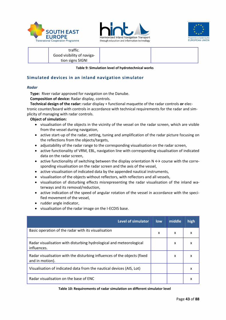
Page 43 of 88
traffic. Good visibility of naviga-
tion signs SIGNI
Table 9: Simulation level of hydrotechnical works
Simulated devices in an inland navigation sim ulator
Radar
Type: River radar approved for navigation on the Danube. Composition of device: Radar display, controls. Technical design of the radar: radar display + functional maquette of the radar controls or elec-
tronic counter/board with controls in accordance with technical requirements for the radar and sim-plicity of managing with radar controls.
Object of simulation:
visualisation of the objects in the vicinity of the vessel on the radar screen, which are visible from the vessel during navigation,
active start-up of the radar, setting, tuning and amplification of the radar picture focusing on the reflections from the objects/targets,
adjustability of the radar range to the corresponding visualisation on the radar screen,
active functionality of VRM, EBL, navigation line with corresponding visualisation of indicated data on the radar screen,
active functionality of switching between the display orientation N ↔ course with the corre-sponding visualisation on the radar screen and the axis of the vessel,
active visualisation of indicated data by the appended nautical instruments,
visualisation of the objects without reflectors, with reflectors and all vessels,
visualisation of disturbing effects misrepresenting the radar visualisation of the inland wa-terways and its removal/reduction,
active indication of the speed of angular rotation of the vessel in accordance with the speci-fied movement of the vessel,
rudder angle indicator,
visualisation of the radar image on the I-ECDIS base.
Level of simulator low middle high
Basic operation of the radar with its visualisation x x x
Radar visualisation with disturbing hydrological and meteorological influences.
x x
Radar visualisation with the disturbing influences of the objects (fixed and in motion).
x x
Visualisation of indicated data from the nautical devices (AIS, Lot) x
Radar visualisation on the base of ENC x
Table 10: Requirements of radar simulation on different simulator level
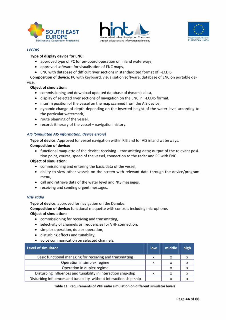
Page 44 of 88
I ECDIS
Type of display device for ENC:
approved type of PC for on-board operation on inland waterways,
approved software for visualisation of ENC maps,
ENC with database of difficult river sections in standardized format of I-ECDIS. Composition of device: PC with keyboard, visualisation software, database of ENC on portable de-
vice. Object of simulation:
commissioning and download updated database of dynamic data,
display of selected river sections of navigation on the ENC in I-ECDIS format,
interim position of the vessel on the map scanned from the AIS device,
dynamic change of depth depending on the inserted height of the water level according to the particular watermark,
route planning of the vessel,
records itinerary of the vessel – navigation history.
AIS (Simulated AIS information, device errors)
Type of device: Approved for vessel navigation within RIS and for AIS inland waterways. Composition of device:
functional maquette of the device; receiving – transmitting data; output of the relevant posi-tion point, course, speed of the vessel, connection to the radar and PC with ENC.
Object of simulation:
commissioning and entering the basic data of the vessel,
ability to view other vessels on the screen with relevant data through the device/program menu,
call and retrieve data of the water level and NtS messages,
receiving and sending urgent messages.
VHF radio
Type of device: approved for navigation on the Danube. Composition of device: functional maquette with controls including microphone. Object of simulation:
commissioning for receiving and transmitting,
selectivity of channels or frequencies for VHF connection,
simplex operation, duplex operation,
disturbing effects and tunability,
voice communication on selected channels.
Level of simulator low middle high
Basic functional managing for receiving and transmitting x x x
Operation in simplex regime x x x
Operation in duplex regime x x
Disturbing influences and tunability in interaction ship-ship x x x
Disturbing influences and tunability without interaction ship-ship x x
Table 11: Requirements of VHF radio simulation on different simulator levels

Page 45 of 88
Echo-sounder
Type of device: approved for navigation on the Danube. Composition of device: functional maquette with controls and indication of depth; output for ra-
dar. Object of simulation:
measured depth under the vessel corresponding with a real position of the vessel on the spe-cific section of the waterways according AIS and on the stretch of ENC.
Rate of turn indicator
Type of device: approved for navigation on the Danube. Composition of device: functional maquette with managing controls. Object of simulation:
corresponding rotation of the vessel depending on the rudder deflection, bow thruster, ves-sel speed, displacement, draft, vessel dimension and the effect of external influences.
Navigation training requirements
Intensity of navigation training on the Inland Navigation Simulator depends on its character and chosen difficulty (complexity). Participants of the navigation training must be able to carry out the minimum training skills depending on the difficulty. Level of difficulty could be divided according to the education target like:
basic trainings for non-professionals
medium level trainings for crew on operational level
high level training for crew on management level (+ practicing LKR if possible)
Skills Basic trainings Medium level trainings High level trainings Addition-al points
Specific manoeuvres
Basic manoeuvres in calm water, naviga-tion in confluence of the rivers, overtaking and passing the ves-sels, turnover of the vessel in calm water, turnover of the ves-
sel up-stream/downstream, navigation in the riv-er arch, navigation
through the narrows
Basic manoeuvres in calm water, navigation in confluence of the riv-
ers, overtaking and passing the vessels,
turnover of the vessel in calm water, turnover of
the vessel up-stream/downstream, navigation in the river
arch with bearing, navi-gation through the nar-
rows with managing traffic, navigation under the bridges in two- way traffic, navigation in the shallows, enter to the
port basin, exit from the port basin, navigation in
ice.
Basic manoeuvres in calm water, nav-igation in conflu-
ence of the rivers, overtaking and
passing the vessels, turnover of the
vessel in calm wa-ter, turnover of the
vessel up-stream/downstrea
m, navigation in the river arch with bearing, navigation
through the nar-rows with manag-ing traffic, naviga-
tion under the bridges with two-
way traffic, naviga-
Naviga-tion with
bow thruster.
Page 46 of 88
tion in the shal-lows, enter to the
port basin, exit from the port ba-sin, navigation in
ice.
Convoy set up
Set up the emergen-cy towed convoy
with secure and fas-ten a towed rope.
Manoeuvring process with vessel focused on combining/untying of the boats to the re-
quired convoy
Manoeuvring pro-cess with a tug
boat in the particu-lar river place fo-
cused on the com-bining/untying of the tug boats to
the required con-voy
Emergency situation
Stopping and an-choring of the vessel with a main engine broken. Manoeuvre in the case of “man
overboard”.
Towing the motor cargo vessel by another vessel upstream/downstream.
Managing the motor cargo vessel without
engine up-stream/downstream.
Managing the ves-sel/tug boat with bro-
ken steering control for the possibilities of
emergency stopping. Manoeuvre in the case of “man overboard”.
Manoeuvring of the vessel with en-
gine failure. Manoeuvring of the vessel in the loss of control
(rudder/nozzle) and stopping the vessel on the wa-
terway. Manoeuvre in the case of “man
overboard”.
All types of the vessel / For all levels
Navigation in different
weather condi-tions
Navigation in clear weather, daylight, dawn/dusk, fog, night conditions, restricted visibility, rain, snow. Navigation under the effect of current and wind. Navigation with
appropriate navigation devices.
Navigation in different types of waterways
Navigation in canal and regulated river, in different water levels, in shallows. Partici-
pants must be able to analyse the particular river section individually and must be able
to adapt navigation to real conditions. Navi-gation under the bridges must be evaluated individually for each under passing. Naviga-
tion in both directions with other vessels with application of CEVNI for different navi-
gation situation.
Defining approximately 3 repre-sentative water levels and wa-terways (canals, rivers, lakes)
Page 47 of 88
Navigation and communication
events
Using radar, I-ECDIS, inland AIS, VHF/UHF radio devices, auto pilot, light controls, en-gine controls, indicators, alarms, internal communication devices and signals, bow
thruster controls.
Participants must be able to communicate with other ves-
sels, traffic controls, authorities, customs, lock operators.
Anchoring Participants must be able to manage an-choring with a bow anchor (front and rear), a stern anchor; using anchor controls (voice, lights), responding to the impacts of anchor-
ing the vessel, anchoring under the influ-ences of stream and wind. Turnover of the
vessel by an anchor.
Locking Participants must be able to pass through a lock, sort a convoy, disconnect and connect convoy necessary for locking, moor the ves-
sel. VHF communication with the lock ac-cording to the procedural process. Manoeu-vring in front of and behind the lock (with-
out the wind influences) with the assistance of the pilot on UHF. Entering the lock simul-taneously with other vessels, positioning to the wall of the lock and side mooring, close the lock (filling or releasing of the lock), exit
from the lock with the front-side or back side wind influences, manoeuvring in re-duced visibility during the day or at night.
Maintaining the manoeuvrabil-ity of the vessel at the nominal
momentum, Stopping the vessel on the accurately determined place of the lock, entering the commands for mooring to the
staff.
Mooring Participants must be aware of the speed influences of mooring and must be able to adjust the speed of the vessel before and
after mooring depending of individual con-ditions. Participants must be able to man-age longitudinal and transverse mooring
and use a bow thruster. Mooring to the dif-ferent kinds of the pontoon.
Participant must adjust speed when the vessel is passing near
other moored vessels.
Others Participant must be aware of the height of the ship, based on actual water level for a
safe navigation under the bridges, electrical cables, etc. Participant must be familiar with
individual rules and regulations of naviga-tion depending of particular river section.
Simulator must be able to indi-cate dangerous or inappropriate navigation with light and sounds
controls.
Table 12: Navigation training requirements
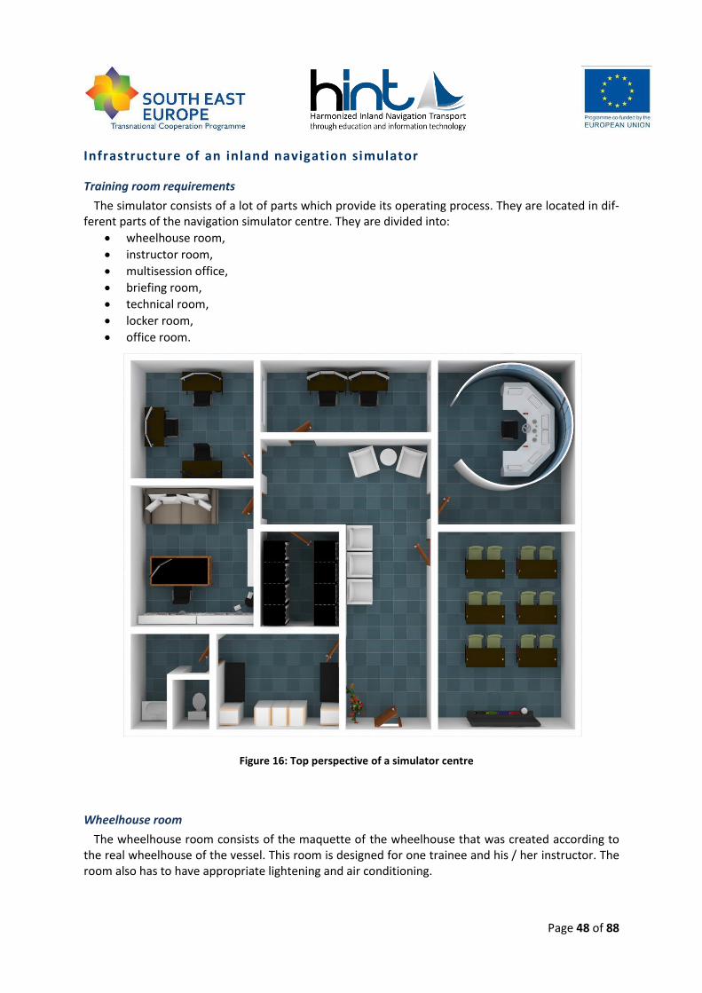
Page 48 of 88
Infrastructure of an inland navigation simulator
Training room requirements
The simulator consists of a lot of parts which provide its operating process. They are located in dif-ferent parts of the navigation simulator centre. They are divided into:
wheelhouse room,
instructor room,
multisession office,
briefing room,
technical room,
locker room,
office room.
Figure 16: Top perspective of a simulator centre
Wheelhouse room
The wheelhouse room consists of the maquette of the wheelhouse that was created according to the real wheelhouse of the vessel. This room is designed for one trainee and his / her instructor. The room also has to have appropriate lightening and air conditioning.
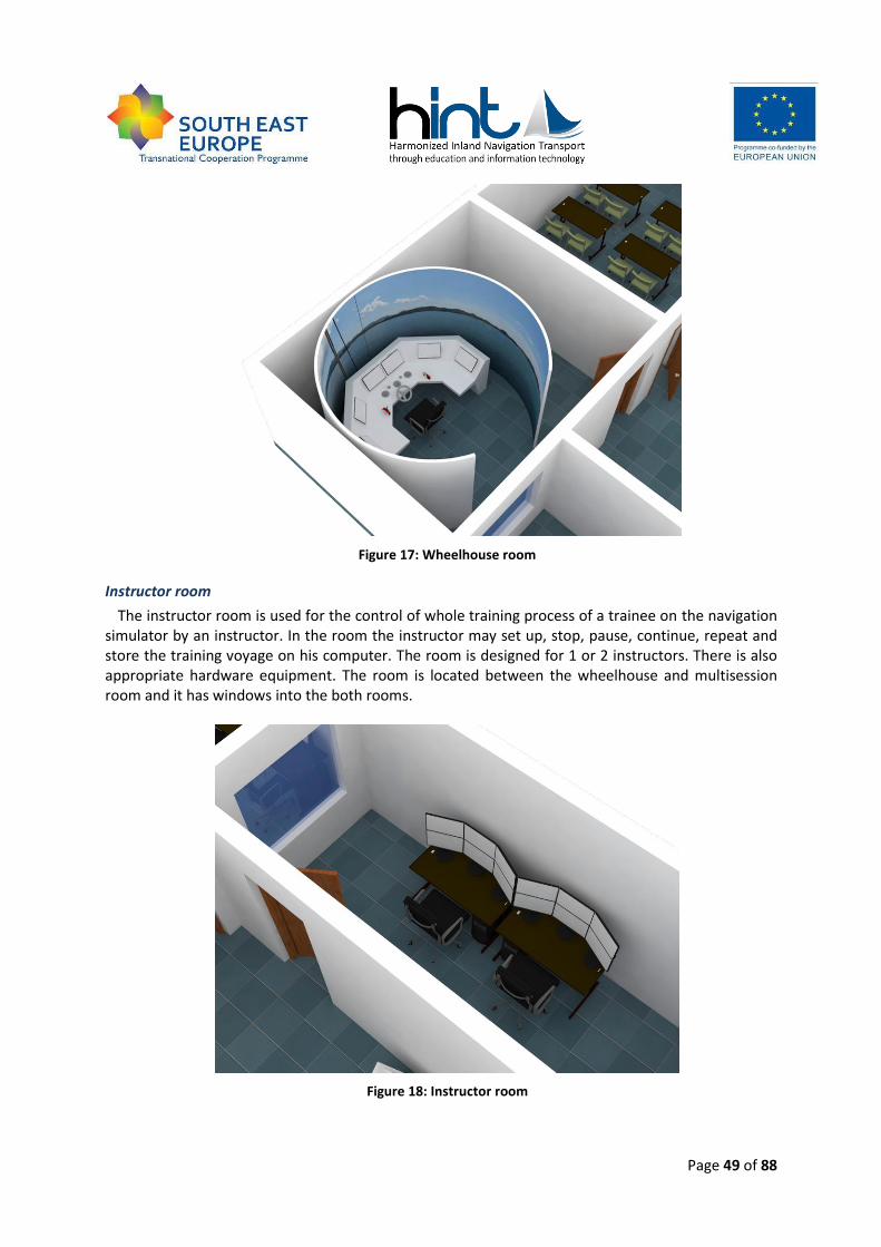
Page 49 of 88
Figure 17: Wheelhouse room
Instructor room
The instructor room is used for the control of whole training process of a trainee on the navigation simulator by an instructor. In the room the instructor may set up, stop, pause, continue, repeat and store the training voyage on his computer. The room is designed for 1 or 2 instructors. There is also appropriate hardware equipment. The room is located between the wheelhouse and multisession room and it has windows into the both rooms.
Figure 18: Instructor room
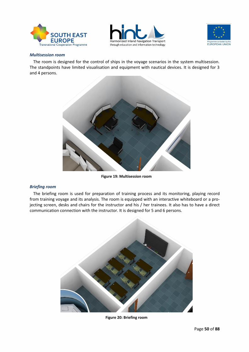
Page 50 of 88
Multisession room
The room is designed for the control of ships in the voyage scenarios in the system multisession. The standpoints have limited visualisation and equipment with nautical devices. It is designed for 3 and 4 persons.
Figure 19: Multisession room
Briefing room
The briefing room is used for preparation of training process and its monitoring, playing record from training voyage and its analysis. The room is equipped with an interactive whiteboard or a pro-jecting screen, desks and chairs for the instructor and his / her trainees. It also has to have a direct communication connection with the instructor. It is designed for 5 and 6 persons.
Figure 20: Briefing room
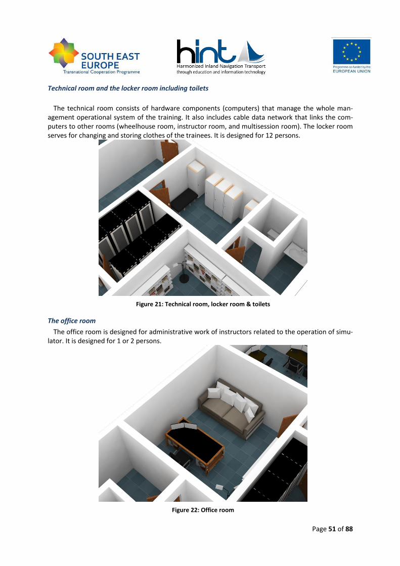
Page 51 of 88
Technical room and the locker room including toilets
The technical room consists of hardware components (computers) that manage the whole man-
agement operational system of the training. It also includes cable data network that links the com-puters to other rooms (wheelhouse room, instructor room, and multisession room). The locker room serves for changing and storing clothes of the trainees. It is designed for 12 persons.
Figure 21: Technical room, locker room & toilets
The office room
The office room is designed for administrative work of instructors related to the operation of simu-lator. It is designed for 1 or 2 persons.
Figure 22: Office room
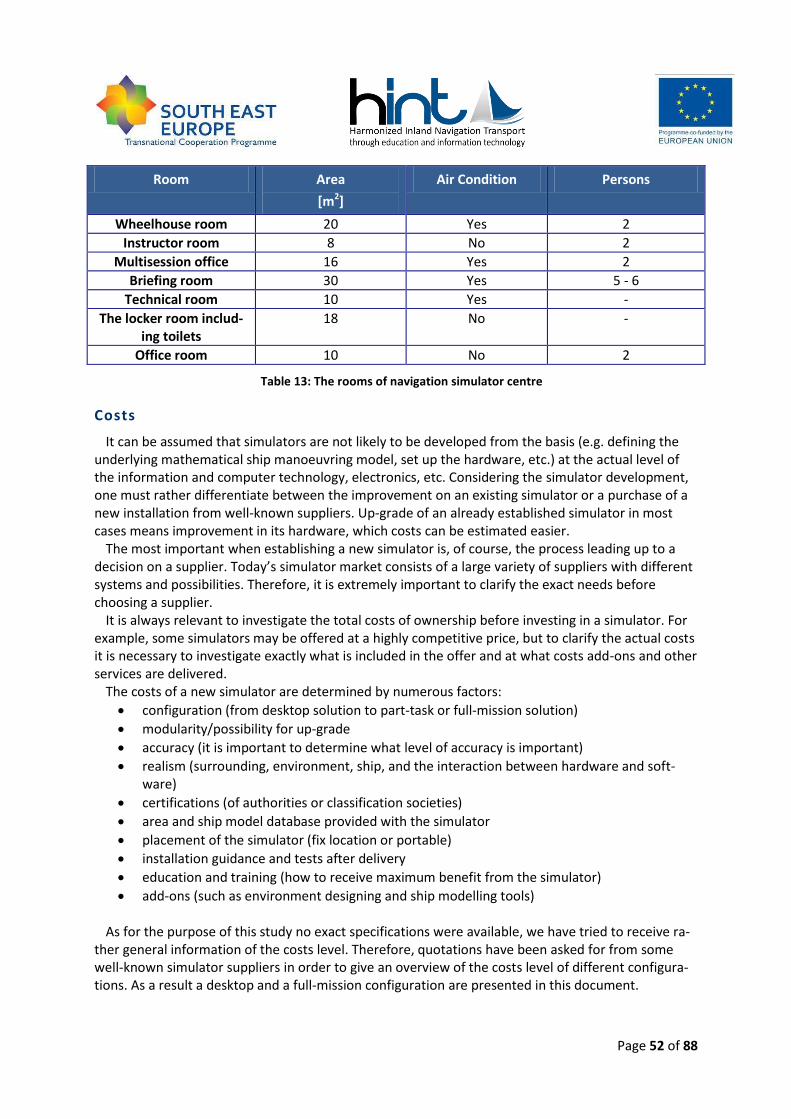
Page 52 of 88
Room Area
[m2]
Air Condition Persons
Wheelhouse room 20 Yes 2
Instructor room 8 No 2
Multisession office 16 Yes 2
Briefing room 30 Yes 5 - 6
Technical room 10 Yes -
The locker room includ-ing toilets
18 No -
Office room 10 No 2
Table 13: The rooms of navigation simulator centre
Costs
It can be assumed that simulators are not likely to be developed from the basis (e.g. defining the underlying mathematical ship manoeuvring model, set up the hardware, etc.) at the actual level of the information and computer technology, electronics, etc. Considering the simulator development, one must rather differentiate between the improvement on an existing simulator or a purchase of a new installation from well-known suppliers. Up-grade of an already established simulator in most cases means improvement in its hardware, which costs can be estimated easier.
The most important when establishing a new simulator is, of course, the process leading up to a decision on a supplier. Today’s simulator market consists of a large variety of suppliers with different systems and possibilities. Therefore, it is extremely important to clarify the exact needs before choosing a supplier.
It is always relevant to investigate the total costs of ownership before investing in a simulator. For example, some simulators may be offered at a highly competitive price, but to clarify the actual costs it is necessary to investigate exactly what is included in the offer and at what costs add-ons and other services are delivered.
The costs of a new simulator are determined by numerous factors:
configuration (from desktop solution to part-task or full-mission solution)
modularity/possibility for up-grade
accuracy (it is important to determine what level of accuracy is important)
realism (surrounding, environment, ship, and the interaction between hardware and soft-ware)
certifications (of authorities or classification societies)
area and ship model database provided with the simulator
placement of the simulator (fix location or portable)
installation guidance and tests after delivery
education and training (how to receive maximum benefit from the simulator)
add-ons (such as environment designing and ship modelling tools) As for the purpose of this study no exact specifications were available, we have tried to receive ra-
ther general information of the costs level. Therefore, quotations have been asked for from some well-known simulator suppliers in order to give an overview of the costs level of different configura-tions. As a result a desktop and a full-mission configuration are presented in this document.
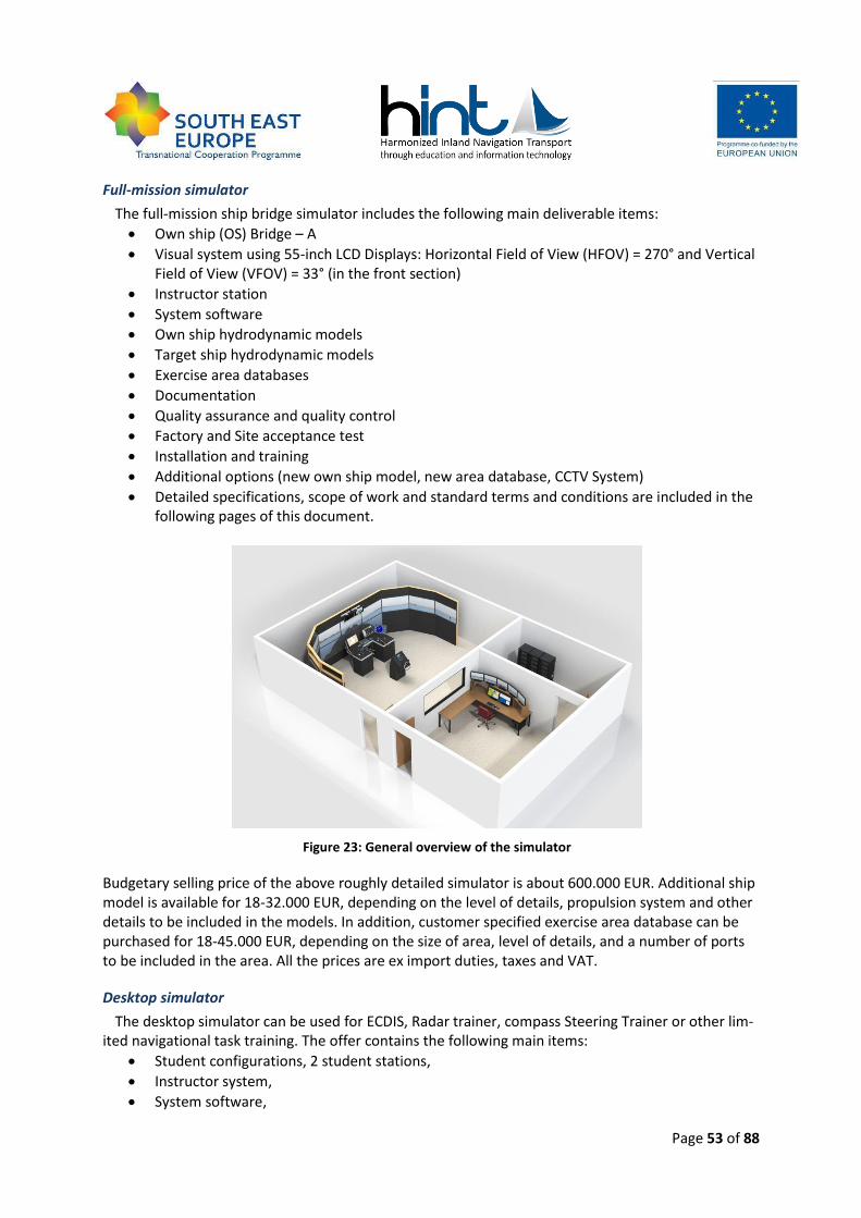
Page 53 of 88
Full-mission simulator
The full-mission ship bridge simulator includes the following main deliverable items:
Own ship (OS) Bridge – A
Visual system using 55-inch LCD Displays: Horizontal Field of View (HFOV) = 270° and Vertical Field of View (VFOV) = 33° (in the front section)
Instructor station
System software
Own ship hydrodynamic models
Target ship hydrodynamic models
Exercise area databases
Documentation
Quality assurance and quality control
Factory and Site acceptance test
Installation and training
Additional options (new own ship model, new area database, CCTV System)
Detailed specifications, scope of work and standard terms and conditions are included in the following pages of this document.
Figure 23: General overview of the simulator
Budgetary selling price of the above roughly detailed simulator is about 600.000 EUR. Additional ship model is available for 18-32.000 EUR, depending on the level of details, propulsion system and other details to be included in the models. In addition, customer specified exercise area database can be purchased for 18-45.000 EUR, depending on the size of area, level of details, and a number of ports to be included in the area. All the prices are ex import duties, taxes and VAT.
Desktop simulator
The desktop simulator can be used for ECDIS, Radar trainer, compass Steering Trainer or other lim-ited navigational task training. The offer contains the following main items:
Student configurations, 2 student stations,
Instructor system,
System software,
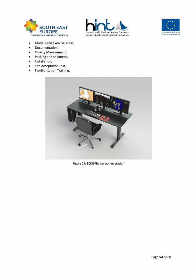
Page 54 of 88
Models and Exercise areas,
Documentation,
Quality Management,
Packing and shipment,
Installation,
Site Acceptance Test,
Familiarisation Training.
Figure 24: ECDIS/Radar trainer station
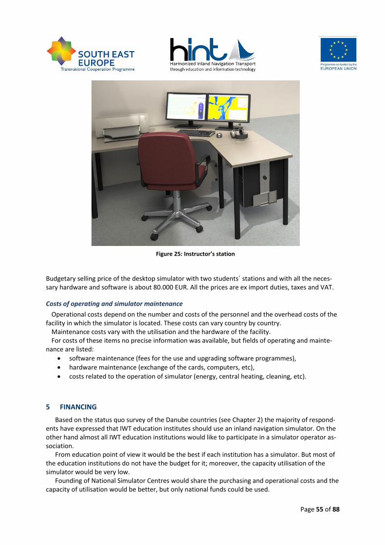
Page 55 of 88
Figure 25: Instructor’s station
Budgetary selling price of the desktop simulator with two students´ stations and with all the neces-sary hardware and software is about 80.000 EUR. All the prices are ex import duties, taxes and VAT.
Costs of operating and simulator maintenance
Operational costs depend on the number and costs of the personnel and the overhead costs of the facility in which the simulator is located. These costs can vary country by country.
Maintenance costs vary with the utilisation and the hardware of the facility. For costs of these items no precise information was available, but fields of operating and mainte-
nance are listed:
software maintenance (fees for the use and upgrading software programmes),
hardware maintenance (exchange of the cards, computers, etc),
costs related to the operation of simulator (energy, central heating, cleaning, etc).
5 FINANCING
Based on the status quo survey of the Danube countries (see Chapter 2) the majority of respond-ents have expressed that IWT education institutes should use an inland navigation simulator. On the other hand almost all IWT education institutions would like to participate in a simulator operator as-sociation.
From education point of view it would be the best if each institution has a simulator. But most of the education institutions do not have the budget for it; moreover, the capacity utilisation of the simulator would be very low.
Founding of National Simulator Centres would share the purchasing and operational costs and the capacity of utilisation would be better, but only national funds could be used.

Page 56 of 88
Establishing the International Association of Danube Navigation Simulator Centres seems to be the most feasible from the economical point of view. In this case the countries could use even the national or international funds for building simulator centres, maintaining and developing simulators, and for organization of national and international trainings (trainer and student exchange, travel, etc). The most expensive part of the simulator is the software background, which could be shared among centres of the association.
The following chapters give some guide on funding programmes, even for individual or coopera-tive Danube Navigation Simulator purchasing and operating. It is important to note that the national and international programmes and the funding systems are changing in time of writing the Danube Navigation Simulator Study. It is possible that some programme is available only for a while or has not been started yet.
National funding opportunities
Private or national funds are available only for individual navigation simulator purchasing, main-taining and operating. The following tables show some examples of national funding programmes, based on information from HINT partners and the National Action Plans of NELI project.
Austria:
Mobilität der Zukunft (Mobility of the Future)
This national programme supports research and development projects contributing to societal chal-lenges in the field of transport and mobility, such as passenger mobility, cargo mobility, vehicle tech-nologies and traffic infrastructure.
Further information
Austrian Research Promotion Agency (FFG)
Link https://www.ffg.at/mobilitaetderzukunft
Table 14: National funding opportunities in Austria
Slovak Republic:
Operational Programme Research and Development
The operational programme is mainly aimed at “modernization and increase of effectiveness of the support system for research and development and improvement of universities' infrastructure in such a way that they contribute to the economy competitiveness increase, regional disparities de-crease, creation of new innovative (high-tech) small and medium-sized enterprises, creation of new jobs and improvement of conditions of the education process at universities”.
Further information
Ministry of Transport, Construction and Regional Development of the Slovak Republic
Link http://www.nsrr.sk/en/operational-programmes/research-and-development/
Page 57 of 88
KEGA
The main objective of the "Projects" is an online solution for administration of the entire lifecycle submitted / solved / financed / finished projects within the grant systems of MŠVVandŠ SR.
Further information
The Ministry of Education, Science, Research and Sport of the Slovak Republic
Link http://www.portalvs.sk/en/projekty
Table 15: National funding opportunities in the Slovak Republic
Hungary:
Széchenyi 2020
Comprehensive development plan for operative development programmes, in which the following planned programmes are interesting for Danube Navigation Simulator:
Research, technology and innovation development.
Access to information and communication technologies, improvement of quality of the use of technologies.
Encouragement of employment and work mobility.
Investments into education, skills development and lifelong learning.
Further information
Link www.szechenyi2020.hu
Human Resource Development Programme (EFOP)
From several priorities the “Infrastructure investments for growing knowledge capital “can be appli-cable for Danube Navigation Simulator.
Further information
Link http://www.palyazat.info/palyazatok/emberi-eroforras-fejlesztesi-operativ-program-efop
Integrated Transport Development Programme (IKOP)
From several priorities the "Improving International (TEN-T), rail and waterway networks" can be ap-plicable for Danube Navigation Simulator.
Further information
Link http://www.palyazat.info/palyazatok/integralt-kozlekedesfejlesztesi-operativ-program-ikop
Table 16: National funding opportunities in Hungary
Page 58 of 88
Croatia:
Supporting programme for inland waterway transport based on de minimis state support
Through this program incentives are carried out for development of inland waterway transport through the de minimis aid. Conditions, criteria and manners of exercising the rights for the grant award are determined below. Eligible for companies which core business is related to IWT.
Further information
Ministry of the Sea, Transport and Infrastructure
Link http://www.mppi.hr/UserDocsImages/POTPORE%20BRD-UPL%204-6_13.pdf
Granting scholarships for water transport and nautical department students
Ministry of Maritime Affairs, Transport and Infrastructure annually grants scholarships to students of water transport and nautical department students. In the academic year 2013/2014 Ministry has awarded 17 scholarships to students of scarce professions. Eleven scholarships are granted to students of Nautical department at Vocational high school (Sisak) and six scholarships are granted to students of Faculty of Maritime Studies. Scholarships for boatmasters were initiated due to lack of experts and in order to increase the inter-est in scarce professions in inland waterway shipping.
Further information
Ministry of the Sea, Transport and Infrastructure
Link http://www.mppi.hr/default.aspx?id=10358
Table 17: National funding opportunities in Croatia
Serbia:
No specific funding programmes for IWT are available in Serbia
Bulgaria:
There are no national programs funding the education and training initiatives.
Romania:
SOP HRD Sectorial Operational Programme for Human Resources Development
Actions supporting linking lifelong learning to the labour market, increasing adaptability of workers and enterprises, promoting active employment measures. The programme is applicable for:
Schools, universities, research centres;
Authorised training providers;
Chambers of commerce and industry;
Unions and employers;
Page 59 of 88
SMEs.
Further information
Managing Authority: The Ministry of Labour, Family and Social Protection
Link http://www.finantare.ro/pos-dru-2010-programul-operational-sectorialdezvoltarea-resurselor-umane_ghid-2010.html http://posdru.edu.ro/index.php/articles/c409/ http://www.fonduri-structurale.ro/Detaliu.aspx?t=resurseumane
Table 18: National funding opportunities in Romania
Ukraine:
There are no specific national programs funding the education and training initiatives in IWT.
International funding opportunities
This survey addresses primarily funding instruments available at European level and at national ones, as a future Danube Navigation Simulator holds a transnational (Danube-wide) character and demands and therefore also transnational funding schemes.
Following potential funding instruments have been identified being accessible between 2014 and 2020 and eventually having affinity for the realisation of the future Danube Navigation Simulator.
Horizon 2020 (FP7)
Horizon 2020 is the biggest EU research and innovation programme ever. Almost €80 billion of funding have been available over seven years (2014 to 2020) – in addition to private and national public investment this money will also attract. Horizon 2020 will help to achieve smart, sustainable and inclusive economic growth. The goal is to ensure that Europe produces world-class science and technology, removes barriers to innovation and makes it easier for the public and private sectors to work together in delivering solutions to big challenges our society faces to.
The Horizon 2020 programme sections are:
Excellent Science
Industrial Leadership
Societal Challenges
European Institute of Innovation and Technology
Euratom
CEF (TEN-T)
As of January 2014, the European Union has a new transport infrastructure policy that connects the continents between East and West, North and South. This policy aims to close the gaps between Member States’ transport networks, remove bottlenecks that still hamper the smooth functioning of the internal market and overcome technical barriers such as incompatible standards for railway traf-fic. It promotes and strengthens seamless transport chains for passengers and freight, while keeping up with future technological trends. This will help the economy in its recovery and growth, with a budget of €26 billion up to 2020.
Page 60 of 88
The infrastructure development of the trans-European transport network is closely linked to the implementation and further advancement of EU transport policy. When, in the past, TEN-T policy was merely perceived as a funding instrument for major projects, it has now grown into a genuine policy which:
Reinforces the network approach, thereby establishing a coherent basis for the identification of projects and for service provision in line with relevant European objectives
Sets standards for the entire network – existing and planned parts – which integrate EU legis-lation in force and lead the way infrastructure-wise to achieve key policy objectives. Existing standards include, in particular, those sets in the fields of railway policy, transport telematics or safety. New policy approaches are enabled in fields such as clean power for transport and other innovative areas, the link between TEN-T and urban mobility or sustainable and high-quality services for freight and passengers.
Highlights the importance of nodes as an integral part of the network: maritime ports and airports as Europe’s gateways, inland ports and rail road terminals as key infrastructure for inter-modal transport chains as well as urban nodes as the origin and destination of the ma-jority of journeys on the trans-European transport network.
Notably, through the new core network corridor approach advance sustainable transport so-lutions which lead the process towards the achievement of the European Union’s long-term transport policy objectives (meeting future mobility needs while ensuring resource efficiency and reducing carbon emissions).
Marco Polo (follow up)
Between 2003 and 2013 Marco Polo aimed to ease road congestion and its attendant pollution by promoting a switch to greener transport modes for European freight traffic. Railways, sea-routes and inland waterways have spare capacity. Companies with viable projects to shift freight from roads to greener modes can turn to Marco Polo for financial support. More than 500 companies have already done so successfully since the programme was launched in 2003.
Five types of projects which shift freight from Europe’s congested roads onto rail, short-sea ship-ping routes and inland waterways, or which avoid road transport, were eligible for Marco Polo grants. The main category concerns direct modal-shift projects (switching to another mode of transport such as rail or sea). The other four include catalyst actions which promote modal shift, mo-torways of the sea actions between major ports, traffic avoidance actions which reduce transport volumes, and common learning actions.
ETC local and cross-border
The European Territorial Cooperation (ETC) is one objective of the Cohesion policy that provides a framework for implementing joint actions and for exchanging experience among different national, regional and local agents. Within this objective three programme types have been differentiated: cross-border, transnational and interregional cooperation through which the EU’s territorial integra-tion and cohesion are to be advanced.
The European Territorial Cooperation financed by the European Regional Development Fund re-mains a separate objective of cohesion policy after 2013, as well. However, it is regulated by a sepa-rate act due to specialities of programmes. European Territorial Cooperation Programmes can be divided into three categories:
Page 61 of 88
1) cross-border cooperation- funding for projects involving regions and local authorities on ei-ther side of a common border, such as projects that aim to develop the cross-border use of infrastructure;
2) transnational cooperation- funding for projects between national, regional and local entities in larger geographical areas;
3) interregional cooperation- to foster sharing good practice on innovation, energy efficiency, urban development and other themes;
New elements of the regulation are of the thematic concentration, close relation with EU2020 Strategy, increased result-orientation of investments and the territorial approach. Provisions on thematic concentration and investment priorities improve the strategic focus of programmes. Ac-cording to the proposed regulation, in case of the cross-border and transnational cooperation mini-mum 80% of EU funds have to be spent on 4 thematic objectives.
According to the current state of ongoing negotiations on 2014-2020 budget, resources for the ETC goal shall amount to 2.75 % of the global resources available from the cohesion Funds, which means 8.9 billion euros. It shall be allocated as following: 74, 06% for CBC programmes, 20,36% for transnational and 5,58% for interregional cooperation.
By focusing on the most local level, the cross-border cooperation, projects can be realised, which will be suggested and implemented by a very limited geographical local region, characterised normal-ly of being a border region.
ETC transnational (i.e. Danube programme, Central Europe programme)
According to the proposal, the European Commission has proposed that the present area of the South East Europe Programme Transnational Cooperation Programme will be covered in the next programming period 2014-2020 by two transnational programmes: Danube and South East Gateway (renamed later on Adriatic-Ionian). These two new programmes will support the development and implementation of two Macro Regional Strategies: Danube and Adriatic-Ionian regions.
The Danube Programme will cover parts of 9 EU countries (Austria; Bulgaria; Croatia; Czech Re-public; Germany (Baden-Württemberg and Bavaria) not the whole territory; Hungary; Romania; Slo-vakia; Slovenia) and 5 non-EU countries (Bosnia and Herzegovina; the Republic of Moldova; Monte-negro; Serbia; Ukraine (not the whole territory), having the same geographical scope than the EU Strategy for the Danube Region.
Thematic priorities of the Danube programme will be defined in line with the relevant draft EC legislation, the national priorities of Partner States, and will reflect the needs of the programme area. Topics to be addressed by programme priorities may include many traditional transnational coopera-tion topics, like innovation, transport, environment, etc.
Other transnational programmes for the Danube regions would be available since 2014 (e.g. Cen-tral Europe programme), but will not be further elaborated, as comparable with the future Danube programme.
ETC international (i.e. INTERREG VC)
INTERREG IVC provided funding between 2007 and 2013 for interregional cooperation across Eu-rope. It was implemented under the European Community’s territorial co-operation objective and financed through the European Regional Development Fund (ERDF). The overall objective of the IN-TERREG IVC Programme was to improve the effectiveness of regional policies and instruments. A pro-ject builds on the exchange of experience among partners who were ideally responsible for the de-velopment of their local and regional policies.
Page 62 of 88
It can be estimated that the future INTERREG VC programme will follow the same basic principles between 2014 and 2020 as the INTERREG IVC did.
Operational Programme Transport (SOPT)
The Operational Programme is a European programme under the Convergence objective co-funded by European Regional Development Fund (ERDF) and the Cohesion Fund (CF). There are Op-erational Programmes (OPs) available for several topics, such as OP Transport (= SOPT), Education etc. OPs are available in several European countries.
In order to achieve the objective of the SOPT it is proposed to allocate the relevant EU and State funds for transport towards the implementation of the following priority axes:
Priority axis 1: Modernization and development of TEN-T priority axes aiming at sustainable
transport system integrated with EU transport networks
This priority axis aims at enhancing the territorial cohesion between Romania and the EU member states, by significantly reduced travel times with improved safety and quality of ser-vice to principal destinations, domestic as well as Europe-wide, for both passengers and freight, along the TEN-T priority axes 7, 18 and 22.
The objective will be achieved through the development and upgrading of motorways and railways, and water transport infrastructure, with a view to improve the quality, efficiency and speed of transport services, door-to-door, and increase volume of freight and passenger traffic from eastern to western Romania.
Priority axis 2: Modernization and development of the national transport infrastructure outside
the TEN-T priority axes aiming at a sustainable national transport system
This priority axis aims at modernizing and developing road, rail, water transport and air transport infrastructure located on the national network outside the TEN-T priority axes and promotes appropriate balance among modes of transport.
Its objective is to increase passenger and freight traffic with the higher degree of safety, speed and quality of service including rail inter-operability; in light of the cohesion policy’s objective of developing secondary network connections.
Priority axis 3: Modernization of transport sector aiming at the higher degree of environmental
protection, human health and passenger safety
This priority axis aims at implementing the principles of sustainable development of the transport sector in Romania, as per the Cardiff conclusions of the European Council (1998) and the European Strategy for Sustainable Development (Gothenburg 2001). It will promote increased levels of safety, minimize adverse effects on the environment as well as promote inter-modal and combined transport.
European Social Fund 2014–2020
The ESF is one of the five European Structural and Investment Funds (ESIF). These have operated under a common framework and pursue complementary policy objectives since 2014. They are the main source of investment at EU level to help Member States to restore and increase growth and ensure job rich recovery while ensuring sustainable development, in line with the Europe 2020 objec-tives.
Objectives for the ESF in 2014-2020:

Page 63 of 88
Getting people into jobs: the ESF will support organisations around the EU to put in place projects aimed at training people and helping them get work. Initiatives supporting entre-preneurs with start-up funding and companies which need to cope with restructuring or a lack of qualified workers will also be funded. Helping young people enter the labour market will be a top priority for the ESF in all EU countries.
Social inclusion: employment is the most effective way of giving people independence, finan-cial security and a sense of belonging. The ESF will continue to finance many thousands of projects that help people in difficulty and those from disadvantaged groups to get skills and jobs and have the same opportunities as others do.
Better education: Across the EU the ESF is financing initiatives to improve education and training and ensure young people to complete their education and get the skills that make them more competitive on the job market. Reducing school drop-out is a priority here, along with improving vocational and tertiary education opportunities.
Stronger public administration: The ESF will support Member States’ efforts to improve the quality of public administration and governance and so support their structural reforms by giving them the necessary administrative and institutional capacities.
The ESF objectives for 2014-2020 “Getting people into jobs” and “Better education” correspond
excellently with the objectives and ideas of a future Danube School Ship, as this concept also wants to stimulate education and training for future working staff in the European inland waterway sector and foster life-long-learning by offering training facilities on board of vessels.
European Social Fund 2014 – 2020:
The European Social Fund will also support measures to reinforce the education and training systems necessary for adapting skills and qualifications of the labour force to work in sectors related to energy and environment.
The European Social Fund has enabled people to use ICT better, to match more effectively peo-ple’s skills to employers’ needs, and particularly to ensure that older workers have appropriate ICT skills.
Lifelong Learning programme (LLL)
As the flagship European Funding programme in the field of education and training, the Lifelong Learning Programme (LLP) enables individuals at all stages of their lives to pursue stimulating learn-ing opportunities across Europe. It is an umbrella programme integrating various education and training initiatives. LLP is divided into four sectorial sub programmes and four so called 'transversal' programmes.
The sectorial sub programmes focus on different stages of education and training and continuing previous programmes:
Comenius for schools
Erasmus for higher education
Leonardo da Vinci for vocational education and training
Grundtvig for adult education From International Danube Navigation Simulator point of view the listed programmes can be ap-
plicable as follows:
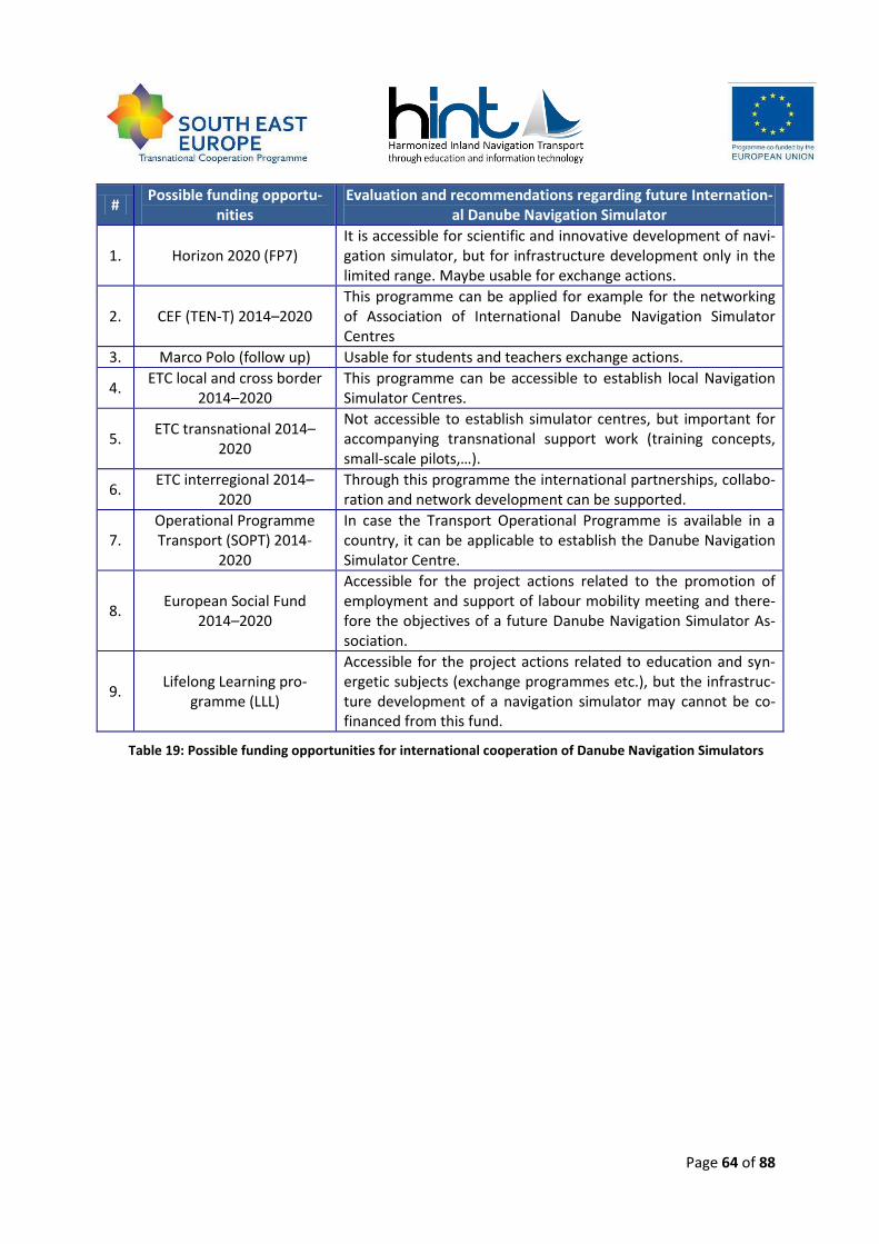
Page 64 of 88
# Possible funding opportu-
nities Evaluation and recommendations regarding future Internation-
al Danube Navigation Simulator
1. Horizon 2020 (FP7) It is accessible for scientific and innovative development of navi-gation simulator, but for infrastructure development only in the limited range. Maybe usable for exchange actions.
2. CEF (TEN-T) 2014–2020 This programme can be applied for example for the networking of Association of International Danube Navigation Simulator Centres
3. Marco Polo (follow up) Usable for students and teachers exchange actions.
4. ETC local and cross border
2014–2020 This programme can be accessible to establish local Navigation Simulator Centres.
5. ETC transnational 2014–
2020
Not accessible to establish simulator centres, but important for accompanying transnational support work (training concepts, small-scale pilots,…).
6. ETC interregional 2014–
2020 Through this programme the international partnerships, collabo-ration and network development can be supported.
7. Operational Programme Transport (SOPT) 2014-
2020
In case the Transport Operational Programme is available in a country, it can be applicable to establish the Danube Navigation Simulator Centre.
8. European Social Fund
2014–2020
Accessible for the project actions related to the promotion of employment and support of labour mobility meeting and there-fore the objectives of a future Danube Navigation Simulator As-sociation.
9. Lifelong Learning pro-
gramme (LLL)
Accessible for the project actions related to education and syn-ergetic subjects (exchange programmes etc.), but the infrastruc-ture development of a navigation simulator may cannot be co-financed from this fund.
Table 19: Possible funding opportunities for international cooperation of Danube Navigation Simulators
Page 65 of 88
6 VALIDATION
The chapter is about the validation process of the Danube navigation simulator that was done by the relevant institutions of the project countries such as:
state authorities,
education institutions,
carriers and port operators
and other institutions that work in the field of inland water transport into the Danube region.
6.1 Approach
The basis for the validation of the concept of the Danube navigation simulator into the Danube re-gion is presented in the chapters 1 to 5 of this document. It consists of the following fields, such as:
status quo analysis:
o Are the results of status quo and demand analysis in the accordance with your country?
simulator classification: o Is the suggested classification structure correct and useful for inland navigation simula-
tors?
Danube navigation simulator:
o Does the concept deal with all important elements of a full bridge inland navigation simulator?
o Are the descriptions and levels of simulator elements clearly and well defined?
o Based on the concept could you define the properties of a simulator which you would need for the education of IWT personnel?
o Could you estimate the costs of a simulator?
financing:
o Based on the funding opportunities could a Danube Navigation Simulator be financed on national or on international level? What kind of funding would you recommend for the Danube Navigation Simulator? (on EU or national level)
o What kind of economic structure could you imagine for operation of Danube navigation simulators? (e.g. international/national or public/private company(ies), independent simulators, association for simulator operation, etc.)
other Comments
The validation of the concept was done by appropriate organisations on the national level.
Because the final version of the concept of the Danube Navigation Simulator Requirements had had over 60 pages, KVD and BME decided to prepare a comprehensive overview of the results of the concept (Annex 2). This overview was sent to the relevant institutions by the project partners that had already participated into the interview related to status quo analysis of navigation simulators. (Annex 1). The validation of the concept was done only the national level.
Page 66 of 88
6.2 National validation feedback
6.2.1 Validation from Austria
Partner responsible for validation: viadonau
Validation feedback from 1 IWT Education Institution The five Austrian stakeholders that were interviewed for the requirement analyses were invited to
validate the finalised Danube Navigation Simulator Concept. Validation feedback was received from one education institution. The respondents are an inland navigation teacher at this school as well as a captain on board of a passenger vessel.
Status quo analysis The Austrian stakeholder agrees with the results of the concept.
Simulator classification The suggested classification structure is correct and clear for the inland navigation expert. It seems to be adequate as a base to create a Danube Navigation Simulator.
Danube Inland Navigation Simulator Concept The description of the concept is clear and well defined. The respondent would appreciate to be able to use the simulator to train skippers and crew in extreme situations (e.g. storms, wind, rain, fog, dismemberment, fire on board, leakage, evacuation).
Financing The simulator shall be financed on an international level (Danube riparian countries and Eu-ropean Commission). The navigation simulator shall be operated by an international, public company that allows renting the simulator also to other private institutions.
Page 67 of 88
6.2.2 Validation from Slovakia
Partner responsible for validation: KVD
Validation feedback from state authorities: - Ministry of Transport, Construction and Regional De-
velopment of the Slovak Republic - Waterborne Transport Development Agency - Transport Office
carrier + port operator:
- Slovak Shipping and Ports education institution:
- Maritime School in Bratislava - DGSA Consulting
other organisations:
- Slovak Navigation Congress The validation process of the concept of the Danube navigation simulator was done under the Slo-
vak national workshop of the project HINT that took place in Bratislava on June, 4th 2014. The De-partment of Water Transport (KVD partner) invited the organizations (state authorities, education institutions, carriers and other organizations) that had been interviewed under the activity related to the status quo and demands of navigation simulators.
Jan Šlesinger presented the concept of the Danube Navigation Simulator (DNS). At the beginning of
his presentation he talked about the results of the questionnaires (interviews) that had been con-ducted between the IWT organizations of the project countries in October 2013. Then he talked about the things related to the concept DNS like dynamic modeling, visualization of environment in-cluding visualization techniques, selection of vessel, hydro technical works on the Danube including simulated stretches. At the end he presented what this simulator looked like.
Status quo analysis The Slovak stakeholders agreed with the results of the status quo analysis. They did not have any comments to it.
Simulator classification The Slovak stakeholders agreed with the prepared simulation classification. They said the quality of simulator depended on a lot of factors like target group of users, the activities that should be trained etc.
Danube Inland Navigation Simulator Concept
The stakeholders agreed with the structure of the concept. There were two comments to this part. Roman Cabadaj (Waterborne Transport Development Agency) asked about the con-formity between the environment in real navigation conditions and simulated environment.
Page 68 of 88
He said that it had to be very hard to simulate the water flows under the dam. Jan Šlesinger answered that the conformity depended on a lot of factors like relevant data about river bed, type of a vessel that was simulated, the quality of programming works and other factors. Vladimír Holčík (Slovak national congress) was interested in multisession (simulation of navi-gation at least two vessels on the waterway). He also suggested the courses for other IWT personal like staff of lock chambers.
Financing
The stakeholders suggest using some EU or national funds / programmes for financing of the simulator. KVD partner has got its own simulator that has already been upgraded through the structural fund. KVD has operated this simulator since 2009 and it is used only on the ed-ucational level of the students.
Page 69 of 88
6.2.3 Validation from Hungary
Partner responsible for validation: BME - Budapest University of Technology and Economics
Validation feedback from 1 Administration 1 Public IWT education institutions 1 Private IWT education institutions 1 Cargo ship operator/ship owners 1 Passenger ship operator/ ship owners
Validation of the Danube Navigation Simulator Concept was fulfilled with personal interviews with
all the stakeholders that were asked for the Danube Navigation Simulator status quo. The main top-
ics of these conversations were based on the DNS Validation questionnaire.
The conclusions of different topics are:
Status Quo Analysis
Interviewed stakeholders agree with the results of the status quo and demand analysis. After
reading through the Danube Navigation Simulator Concept neither partner was changed his view.
Simulator Classification
The stakeholders had positive feedback about the classification of inland navigation simulators.
The education institutions and the authority expressed that in the future the types should be
subdivided according to the education purposes. The ship owners and the education institutes
expressed the need for a legal regulation, which gave more detailed description of the simulator
classes.
Danube Inland Navigation Simulator Concept.
The interviewed people gave positive feedback about the concept. An education institute and a ship owner missed the definition of emergency and internal communication equipment, but they agreed this cannot be base of a misunderstanding if the simulator bridge layout fulfils the stand-ards and requirements of regulations.
The ship owners mentioned that the concept would be more accurate if the description of simu-lator elements contained the names and numbers of the relevant international standards.
The ship owners expressed that they did not want to define the properties of an inland naviga-tion simulator, because they send their crew only to certified courses (this means that the simu-lator is also certified). The education institutes told about the concept that the concept is a good basis by the first step of a simulator purchase, but during the process more details have to be cleared.
About simulator cost the stakeholders cannot have more information than the DNS concept.

Page 70 of 88
Financing
The stakeholders of authority and the public education institute could imagine (with low chance)
to purchase an inland navigation simulator from national education programme budget, but all
interviewed stakeholders indicated that international funds could be more available.
The asked partners can imagine several ways of operation of the Danube navigation simulators,
but most of the stakeholders taught that the most effective would be an international associa-
tion who operates the simulators. But the non member institutes could also rent time in the
Danube navigation simulators.
Based on the interviews it is noted that the education institutes and the authority taught an own
simulator more effective/comfortable from education point of view.
Are any aspects you do not agree with?
It was not mentioned in the DNS concept, but most of stakeholders expressed that training on an
inland navigation simulator did not replace the on board training, however the simulator as an
education tool would be useful.
Do you have any supplements or change proposals?
All of the interviewed partners agreed that the application of navigation simulators in the crew
training have to be regulated by international standards and regulations, which are parts of the
education and training harmonisation. Unless this the simulators will not be commonly used due
to the prices.
Other Comments
There was no other comments.
Page 71 of 88
6.2.4 Validation from Croatia
Partner responsible for validation: FPZ - Faculty of Transport and Traffic Sciences
Validation feedback from 2 IWT Education Institution 2 Cargo Vessel Operator
The validation of the Danube navigation simulator concept was conducted with all the stakeholders
that were interviewed for the Danube navigation simulator. Stakeholders that were interviewed are:
Danube Lloyd Ltd.,
Brodocentar Ltd.,
Faculty of Transport and Traffic Sciences of University of Zagreb
Vocational School Sisak
Regarding the Status quo and demand analysis of the concept all of the stakeholders agree that purchase or rent of simulator is a good idea. Also, all of the interviewed partners consider that classi-fication structure is correct and useful for inland navigation simulator.
One stakeholder stated that concept does not include all important elements of a full bridge in-land navigation simulator, but other three partners agree with the proposed concept.
Furthermore, the same stakeholder stated that descriptions and levels of simulator elements are not clearly and well defined explaining that simulator should clearly define which ship types will be simulated and include all aspects which will be encountered in practice. Other three stakeholders do not agree with that statement. They consider that it is necessary to integrate all specifics of water-ways and inland navigation in simulator.
Regarding to the financing, all of stakeholders consider that simulator should be financed from EU funds, not from local institution budget, because most of professional staff will not find job in Croatia. Three of four partners stated that education should be carried out on some independent simulator or on some other existing institution.
All of stakeholders stated no aspects they do not agree with. Two of partners have a few proposals. One suggests dissemination of leaflets to ship crew to get
insight with advantage of using simulator for education purposes and other partner stated that teachers also have to be trained to work on simulator.
Finally, all of stakeholders stated that nautical simulator is a good idea and it will create a posi-tive effect on staff education (in terms of reducing stress, making the routine to resolve problems).
Page 72 of 88
6.2.5 Validation from Serbia
Partner responsible for validation: SBBH – School of shipping, shipbuilding and hydrobuilding
Validation feedback from 1 State owned shipping company 2 Public IWT education institutions
The participants in the validation consider the navigation simulator an interesting and useful tool to
have in one’s institution. However, the problem could be that the stakeholders are not as interested
as the education institutions are.
General conclusion of Serbian stakeholders is that training on an inland navigation simulator did
not replace the on board training.
Validation of the Danube Navigation Simulator Concept was fulfilled with personal interviews with
some stakeholders that were asked for the Danube Navigation Simulator status quo and one stake-
holder who were not asked. The main topics of these conversations were based on the DNS Valida-
tion questionnaire.
The conclusions of different topics are:
Status Quo Analysis
Interviewed stakeholders agree with the results of the status quo and demand analysis. The analysis
was done in great detail. The proper questions on the questionnaire resulted in accurate analysis. The results
show a useful side of the navigation simulator. However, it also shows that there is a not too much interest
among stakeholders for the procurement of simulators.
Simulator Classification
The stakeholders had positive feedback about the classification of inland navigation simulators.
Classification structure is correct and complete and it describes all the possible variants of the inland
navigation simulator. One of the stakeholders considers that class E, exhibition inland navigation
simulator, is unnecessary.
Danube Inland Navigation Simulator Concept.
The interviewed people gave positive feedback about the concept. Based on the concept all the requirements for simulator training of IWT personnel can be defined. Education institutes consider that it has not covered all the emergency situations such as simulation of fire or hull sinking. Also, the concept does not cover ship stability problems, loading and unloading operations, communica-tion among crew members and the main bridge.
As for the expenses, the stakeholders could not determine the cost considering the data presented,
it is possible they could amount up to 1.000.000 euros. What’s certain is that they exceed the fund-
ing opportunities in Serbia.

Page 73 of 88
Financing
The Serbian stakeholders consider that the best possible solution concerning the finances are in-
ternational funds, a necessary help should be established on an international level.
Are any aspects you do not agree with?
In DNS concept there are no special parts with which they disagree.
Do you have any supplements or change proposals?
All the important are mentioned. It is certain that the concept has opened some new questions, which
would change or add some other elements.
Other Comments
, The most important for training of crew members (secondary school level) is practice on board. Naviga-
tion simulator can be very useful for university level, like the concept of research inland navigation simulator.
Page 74 of 88
6.2.6 Validation from Bulgaria
Partner responsible for validation: FPZ - Faculty of Transport and Traffic Sciences
Validation feedback from 4 cargo ship operators: Bulgarian River Shipping JSCo., Executive Agency for Exploration and Maintenance of the Danube River (EAEMDR), Cosmos Energy LTD, Rubiships LTD. 1 private IWT education institution Seaman centre, Ruse
The answers to the questions are as follows:
Status quo analysis All stakeholders agree with the obtained results.
Simulator classification All stakeholders agree with proposed structure of the simulator.
Danube Inland Navigation Simulator Concept : All stakeholders agree that the concept deals with all important elements of a full bridge nav-igation simulator, but 20 % of them proposed to be added “hands-free” option by pedals. All stakeholders agree with the descriptions and levels of simulators, only one in the face of the Private IWT education institute wants more detailed description. All stakeholders like simulator of the class AA and class S. Therefore they propose the simu-lator to have maximal possibilities – all river vessels types and conditions. All stakeholders cannot the answer for the question related to the costs of a simulator. Only one expect the simulator costs can be around 2 000 000 euro.
Financing: Almost all stakeholders propose funding on international level. Only one suggests that a mixed financing on national and on international level whit participation of private compa-nies. All companies proposed any association for simulator operation, where will participate public and private structures in IWT.
Are there any aspects you do not agree with? At this point all responded that they had no comments.
Do you have any supplements or change proposals? The main proposals are: to simulate the movement of the bridge – up and down; The bridge to have a camera to see what's under it; The captain can see from the bridge on the 360 degrees; Captains to be educated for work with documents; To be created an international education staff with members from each country on the Danube river.

Page 75 of 88
Other Comments All respondents have no comments.
Page 76 of 88
6.2.7 Validation from Romania
Partner responsible for validation: CERONAV Validation feedback from 1 IWT Education Institution
1 Port Operator 2 Shipping companies
Status Quo Analysis Interviewed stakeholders agree with the results of the status quo and demand analysis. Union of Romanian Inland Ports (UPIR) believes that the chapter Conclusions should have referred to the CCNR document “Features of the simulator for inland navigation”.
Simulator Classification Positive feedback from all interviewed stakeholders, who consider it well structured, with the remark however that classification should wither consist of simulators for IWT professional only or types of equipment should be useful for IWT professionals.
Danube Inland Navigation Simulator Concept. Strong positive feedback to all questions in the questionnaire.
Financing All interviewed stakeholders indicated Connecting Europe Facility and the Danube Transnational Programme.
Are any aspects you do not agree with? Three stakeholders consider that simulation equipment for IWT professionals is rather too so-phisticated for the target group addressed and one stakeholder does not agree with cost of equipment.
Do you have any supplements or change proposals? Professional level/degree of trainer working with high/complete level of simulation equip-
ment should be defined; Simulation concept should be in line with education and training harmonization activities; Equipment should include specific facilities for train the trainer.
Other Comments Requirements regarding training of IWT professionals on simulators should be harmonized in
the Danube region countries;
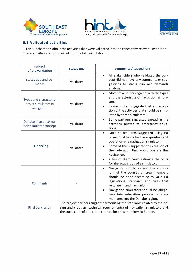
Page 77 of 88
6.3 Validated activit ies
This subchapter is about the activities that were validated into the concept by relevant institutions. These activities are summarized into the following table.
subject of the validation
status quo comments / suggestions
status quo and de-mands
validated
All stakeholders who validated the con-cept did not have any comments or sug-gestions to status quo and demands analysis.
Types and characteris-tics of simulators in
navigation validated
Most stakeholders agreed with the types and characteristics of navigation simula-tors.
Some of them suggested better descrip-tion of the activities that should be simu-lated by these simulators.
Danube inland naviga-tion simulator concept
validated Some partners suggested spreading the
activities related to emergency situa-tions.
Financing
validated
Most stakeholders suggested using EU or national funds for the acquisition and operation of a navigation simulator.
Some of them suggested the creation of the federation that would operate this navigation.
a few of them could estimate the costs for the acquisition of a simulator.
Comments -
Navigation simulators and the curricu-lum of the courses of crew members should be done according to valid EU legislations, standards and rules that regulate inland navigation.
Navigation simulators should be obliga-tory into education process of crew members into the Danube region.
Final conclusion The project partners suggest harmonising the standards related to the de-sign and creation (technical requirements) of navigation simulators and the curriculum of education courses for crew members in Europe.

Page 78 of 88
LIST OF ANNEXES
Annex 1 Questionnaire Danube Navigation Simulator
Annex 2 Executive summary
Annex 3 The list of the organizations that validated the concept per countries
Page 79 of 88
ANNEX 1
Questionnaire Danube Navigation Simulator
1. Experience
1.1. Does your organisation have experience with navigation simulators?
Yes, we have experience with maritime navigation simulator.
Yes, we have experience with inland navigation simulator.
No.
1.2. Does your organisation own any simulators?
Yes No
If yes, indicate which type of simulator: ______________________________________________
1.3. Does your organisation plan to buy or rent a navigation simulator?
Yes No
2. User groups
2.1. For which job profiles do you think inland navigation simulator training could be relevant ?
Ship crew at management level (Boatmaster, officers, etc.)
Ship crew on deck at operational level (deckhands, helmsman, boatswain, etc.)
Ship machinery crew at operational level
Other: ..............................................................
2.2. Who would be the users of an inland navigation simulator in your organisation?
Students*……..
Apprentices*…….
IWT experts*…….
Others*……………………………………………………………..
Nobody
* How many
Page 80 of 88
2.3. Estimation: How many days would your country/institution/school use the simulator per year?
________________________
3. Education
3.1. For which topics do you think an inland navigation simulator could be used?
Navigation
Local Knowledge Requirements (LKR)
Using radar
Using VHF radio device
Using ECDIS device
Using AIS device
Others: ......................................
3.2. Do you think that the use of suitable inland navigation simulators can replace the practice time on board?
No, the practice time cannot be replaced.
Yes, .............................% of practice time can replaced by using a suitable inland navigation sim-ulator.
4. Use of Inland navigation simulator
4.1. What kind of navigation exercise has to be simulated by an inland navigation simulator?
Passing and overtaking vessel
Mooring
Anchoring
Locking
Convoy set up
Specific manoeuvres
Navigation in different weather conditions (fog, wind, rain, snow, etc.)
Navigation in complex current stream
Navigation in channel and in shallow water; grounding and squat
Emergency situations
Navigation and communication events (use of radar, radio, AIS, ECDIS, etc.)

Page 81 of 88
4.2. What types of ships should be simulated by a Danube inland navigation simulator?
Single vessel
Convoy
Other: .................................
4.3. Do you think it is necessary to simulate real stretches of the Danube?
Yes, the whole Danube has to be simulated
Yes, the different exercises have to cover the most difficult navigation stretches on the Danube
No, the river/weather/surroundings/etc. have to be simulated according to the education target
4.4. Please describe which stretches of the Danube have to be simulated, and why?
Difficult stretches:…………………………………………………………………………………………………..
Ports:………………………………………………………………………………………………………………………..
Locks:………………………………………………………………………………………………………………………..
Others:……………………………………………………………………………………………………………………..
4.5. What are the minimum requirements of the bridge layout of an inland navigation simu-lator?
Please specify with some words: .........................................................................................................................................................................................................................................................................................................................................................................................................................................................................................................................................
5. Financing
5.1. Do you think that every IWT education institute should have or rent or share use of an Inland Navigation Simulator?
Yes.
Yes, but just the institutes which train the navigation personnel.
No, but a mandatory use of a simulator centre per country would be useful.
No, but a voluntary use of a simulator centre per country would be useful.
No, the use of an inland navigation simulator is voluntary.
Other: ...............................................................

Page 82 of 88
5.2. Would you be interested to make use of an Inland Navigation Simulator?
Yes, because: _____________________________________________________________________
No, because: _____________________________________________________________________
5.3. Would you be interested to participate in an international association running the Simula-tor?
Yes, because: _____________________________________________________________________
No, because: _____________________________________________________________________
5.4. Would you be willing to financially contribute to the purchase and/or operation of the Inland Navigation Simulator?
Yes, because: _____________________________________________________________________
No, because: _____________________________________________________________________
6. General
6.1 What is the type of your organisation?
Public IWT education institute.
Private IWT education institute.
Passenger ship operator / ship owner.
Cargo ship operator / ship owner.
Public authority or other administration institution.
Other: ..................................
6.2 Contact Details (optional)
Name:
Organisation
Email:
6.3 Are you interested in further information?
Yes No

Page 83 of 88
7. Comments:
Page 84 of 88
ANNEX 2
Danube Navigation Simulator Concept
Executive Summary
Need for the Danube Navigation Simulator Navigation simulators are commonly used in maritime crew training, but in inland navigation it is a
new, dynamically developing training method. However, the maritime experience provides the basis for simulator application in inland navigation research and training, the inland navigation simulators are new born techniques due to the specialities of inland navigation. Because of this the basic re-quirements and concepts of inland navigation simulator trainings have to be defined, like in maritime education. Requirements in the Danube region
In October 2013 the responsible partners conducted the interviews with the national stakeholders. Over 50 organisations (cargo/passenger operators, education institutions (private/public) and au-thorities) from different Danube countries filled the questionnaire focused on the needs of the Dan-ube Navigation Simulator. The basic goal was to analyse the requirements in the field of inland navi-gation simulators in the Danube countries. About 25 % of the organisations have already had some experience with the navigation simulators. Only 2 partners from Slovakia and Ukraine have had ex-perience with the inland navigation simulators (University of Zilina, Slovakia and ONMA, Ukraine). A few organisations are planning to buy or rent the simulator. It depends mainly on their financial situ-ation. Nowadays, most of them do not have enough funds to buy their own simulator. One way how to solve this problem is to establish an international association that could buy and operate it.
The Danube Navigation Simulator should be used for training of these job positions:
ship crew at management level (Boatmasters, captains, etc.),
ship crew on the deck at operational level (deckhands, boatswains, etc.). According to the survey the target group of the simulator should be mostly students and appren-
tices. The respondents suggest the training of mainly the following topics: navigation and manoeu-vring, using of radar, I-ECDIS and AIS.
About 50 % of the respondents think that the simulator can replace practical training on the ves-
sel. The survey was also aimed at the analysis of the relevant exercises which should be trained on the simulator.
Training scenario should consist of the following activities: passing and overtaking the vessel, moor-ing, anchoring, locking, convoy set up, specific manoeuvres, navigation in the different weather conditions (fog, wind, rain, snow, etc.), navigation in a complex current stream, navigation in a chan-nel and in shallow water; grounding and squat, emergency situations, navigation and communication events (use of radar, radio, AIS, ECDIS, etc.). The most preferred education topic is navigation, but all activities in the wheelhouse should be trained. All respondents consider that not only one type of the vessel should be simulated. They would like to simulate a single vessel and also a convoy.
Simulation of the Danube is very difficult, because some parts of the Danube are not regulated (the middle and lower part). The river bed in these areas is unstable.
Page 85 of 88
Most of the organisations are interested in using the navigation simulator. Only less than 20 % of
them would not like to use it for navigation purposes. The participation in financing of the simulator depends on the financial situation of a particular or-
ganisation. The private or public education institutions would like to participate in financing of the simulators, but it will depend on the way of financing. Other institutions are not interested in buying or renting the simulator. Summary of Danube Navigation Simulator Concept Dynamical Model
The principle of navigation simulation is the dynamical model of the vessel and the environment. The natural sciences are trying to describe reality by various quality models. Therefore, the vessel and the environment models for inland navigation simulation can be also on the different level.
For the basic level of navigation simulation the simple dynamical models with less accuracy can be enough, but for the higher level of simulation the precision of models has to be high. The higher the quality of the model, the greater technical background is required.
The level of navigation simulation model is defined by the number of considered effects and its modelling quality. This study defines three levels (low, middle and high) in dynamical modelling of the vessel and the environment.
Ship Types The simulated ship type is one of the most important parts in the preparation of the concept of the
Danube Navigation Simulator. While well-defined vessel types can be simulated in Western European united waterways, the ships on the Danube are very different in size, even in functionality. Because of this fact only general ship types and special vessels can be defined for navigation simulation on the Danube Navigation Simulator. Visualisation and Layout of the Inland Navigation Simulator
Visualisation of the environment for the inland navigation simulator must be based on minimum requirements for a sectorial view of the wheelhouse on a real vessel. It consists of technical perfor-mance of visualisation and visualisation of the environment, which should truly correspond to the real environment. Required visualisation of the environment according to the difficulty of simulation and fulfilment of navigation training has to be done for all navigation objects and characteristics. Navigation Environment on the Danube and Local Knowledge Requirements
On the inland waterways there are a lot of hydrotechnical facilities which significantly affect navi-gation conditions and boatmen. Depending on the difficulty of simulation, the particular facilities have to be simulated (locks, bridges, ports etc.). The list of the Local Knowledge Requirements pro-vides the overview of difficult stretches of the Danube in each country. Navigation Devices of the Inland Navigation Simulator
Navigation devices on the vessel are an inseparable part of navigation. They have to be simulated similarly to the real vessel navigation. Technical design and location have to be also identical. The
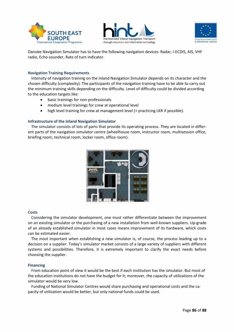
Page 86 of 88
Danube Navigation Simulator has to have the following navigation devices: Radar, I-ECDIS, AIS, VHF radio, Echo-sounder, Rate of turn indicator.
Navigation Training Requirements Intensity of navigation training on the Inland Navigation Simulator depends on its character and the
chosen difficulty (complexity). The participants of the navigation training have to be able to carry out the minimum training skills depending on the difficulty. Level of difficulty could be divided according to the education targets like:
basic trainings for non-professionals
medium level trainings for crew at operational level
high level training for crew at management level (+ practicing LKR if possible). Infrastructure of the Inland Navigation Simulator
The simulator consists of lots of parts that provide its operating process. They are located in differ-ent parts of the navigation simulator centre (wheelhouse room, instructor room, multisession office, briefing room, technical room, locker room, office room).
Costs Considering the simulator development, one must rather differentiate between the improvement
on an existing simulator or the purchasing of a new installation from well-known suppliers. Up-grade of an already established simulator in most cases means improvement of its hardware, which costs can be estimated easier.
The most important when establishing a new simulator is, of course, the process leading up to a decision on a supplier. Today’s simulator market consists of a large variety of suppliers with different systems and possibilities. Therefore, it is extremely important to clarify the exact needs before choosing the supplier. Financing
From education point of view it would be the best if each institution has the simulator. But most of the education institutions do not have the budget for it; moreover, the capacity of utilizations of the simulator would be very low.
Funding of National Simulator Centres would share purchasing and operational costs and the ca-pacity of utilization would be better, but only national funds could be used.

Page 87 of 88
The establishment of the International Association of Danube Navigation Simulator Centres seems to be the most feasible from economical point of view. In this case the countries could use even the national or international funds for building of simulator centres, maintaining and developing simula-tors, and for organizing national and international trainings (trainer and student exchange, travel, etc).
Contact details:
Andrej David – University of Zilina, Slovakia, [email protected], Csaba Hargitai – Budapest University of Technology and Economics, Hungary, cshar-
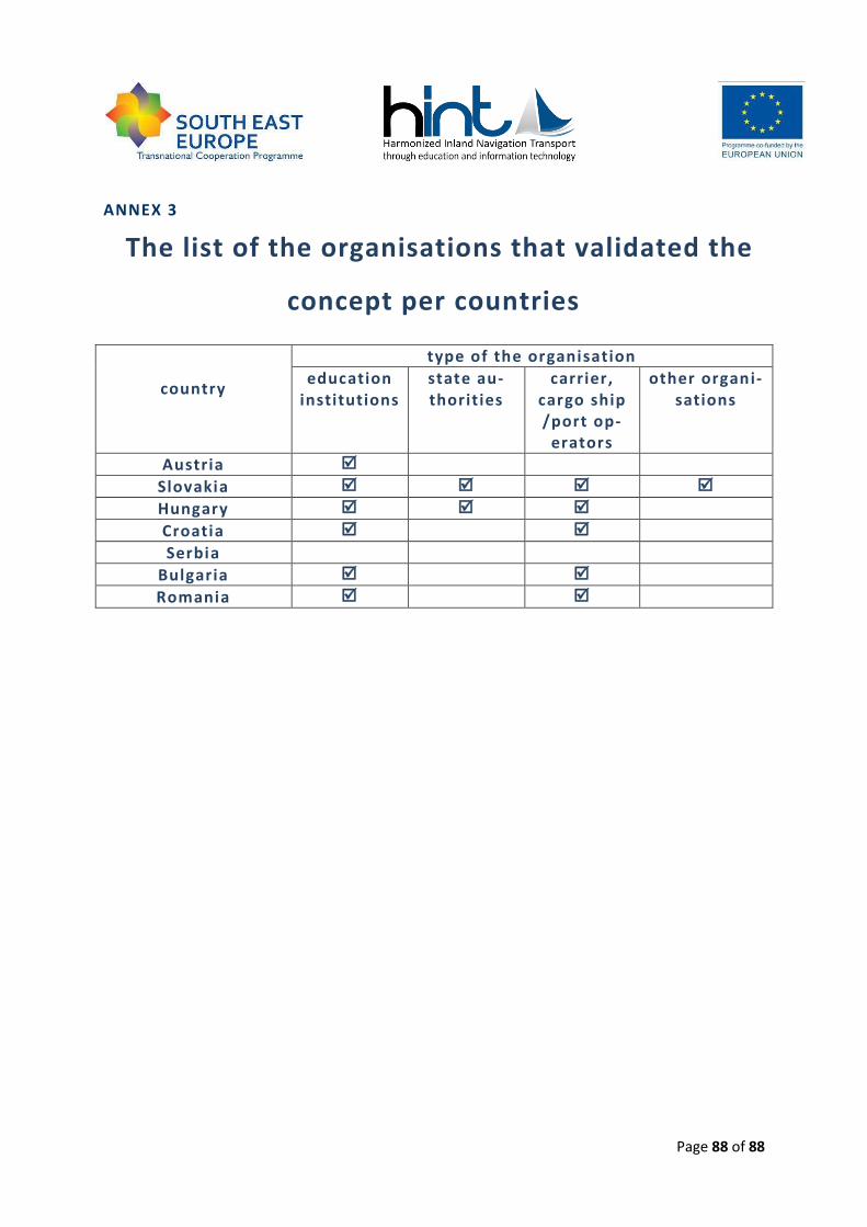
Page 88 of 88
ANNEX 3
The list of the organisations that validated the
concept per countries
country
type of the organisation
education institutions
state au-thorities
carrier, cargo ship /port op-
erators
other organi-sations
Austria
Slovakia
Hungary
Croatia
Serbia
Bulgaria
Romania