12H - publicdocs.txdot.gov · Gray c 169-7-16 U.S. 60 333,800.00 Hidalgo C 255-8-14 U.S. 281...
77
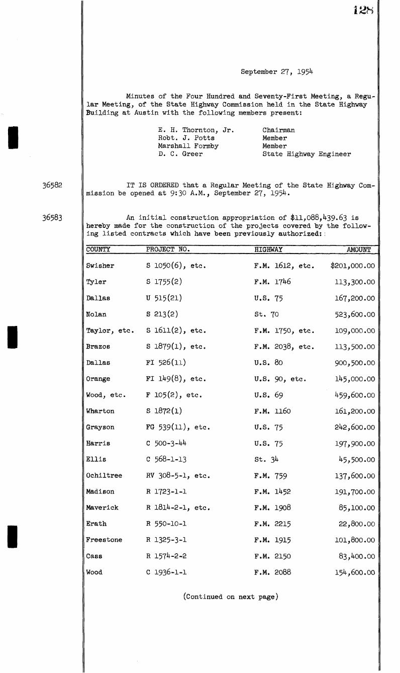
12H i 36582 36583 1 1 September 27, 1954 Minutes of the Four Hundred and Seventy-First Meeting, a Regu- lar Meeting, of the State Highway Commission held in the State Highway Building at Austin with the following members present: E. H. Thornton, Jr. Root. J. Potts Marshall Formby D. C. Greer Chairman Member Member State Highway Engineer IT IS ORDERED that a Regular Meeting of the State Highway Com- mission be opened at 9:30 A.M., September 27, 1954. An initial construction appropriation of $11,088,439.63 is hereby made for the construction of the projects covered hy the follow- ing listed contracts which have been previously authorized:. COUNTY PROJECT NO. HIGHWAY AMOUNT Swisher S 1050(6), etc. F.M. 1612, etc. $201,000.00 Tyler S 1755(2) F.M. 1746 113,300.00 Dallas u 515(21) U.S. 75 167,200.00 Nolan s 213(2) st. 70 523,600.00 Taylor, etc. S 1611(2), etc. F.M. 1750, etc. 109,000.00 Brazos S 1879(1), etc. F.M. 2038, etc. 113,500.00 Dallas FI 526(11) U.S. 80 900,500.00 Orange FI 149(8), etc. U.S. 90, etc. 145,000.00 Wood, etc. F 105(2), etc. U.S. 69 459,600.00 Wharton s 1872(1) F.M. 1160 161,200.00 Grayson FG 539(H), etc. U.S. 75 242,600.00 Harris c 500-3-44 U.S. 75 197,900.00 Ellis c 568-1-13 St. 34 45,500.00 Ochiltree RV 308-5-1, etc. F.M. 759 137,600.00 Madison R 1723-1-1 F.M. 1452 191,700.00 Maverick R 1814-2-1, etc. F.M. 1908 85,100.00 Erath R 550-10-1 F.M, 2215 22,800.00 Freestone R 1325-3-1 F.M. 1915 101,800.00 Cass R 1574-2-2 F.M. 2150 83,400.00 Wood c 1936-1-1 F.M. 2088 154,600.00 (Continued on next page)
Transcript of 12H - publicdocs.txdot.gov · Gray c 169-7-16 U.S. 60 333,800.00 Hidalgo C 255-8-14 U.S. 281...
12H
i 36582
36583
1
1
September 27, 1954
Minutes of the Four Hundred and Seventy-First Meeting, a Regular Meeting, of the State Highway Commission held in the State Highway Building at Austin with the following members present:
E. H. Thornton, Jr. Root. J. Potts Marshall Formby D. C. Greer
Chairman Member Member State Highway Engineer
IT IS ORDERED that a Regular Meeting of the State Highway Commission be opened at 9:30 A.M., September 27, 1954.
An i n i t i a l construction appropriation of $11,088,439.63 is hereby made for the construction of the projects covered hy the following listed contracts which have been previously authorized:.
COUNTY PROJECT NO. HIGHWAY AMOUNT
Swisher S 1050(6), etc. F.M. 1612, etc. $201,000.00
Tyler S 1755(2) F.M. 1746 113,300.00
Dallas u 515(21) U.S. 75 167,200.00
Nolan s 213(2) st. 70 523,600.00
Taylor, etc. S 1611(2), etc. F.M. 1750, etc. 109,000.00
Brazos S 1879(1), etc. F.M. 2038, etc. 113,500.00
Dallas FI 526(11) U.S. 80 900,500.00
Orange FI 149(8), etc. U.S. 90, etc. 145,000.00
Wood, etc. F 105(2), etc. U.S. 69 459,600.00
Wharton s 1872(1) F.M. 1160 161,200.00
Grayson FG 539(H), etc. U.S. 75 242,600.00
Harris c 500-3-44 U.S. 75 197,900.00
E l l i s c 568-1-13 St. 34 45,500.00
Ochiltree RV 308-5-1, etc. F.M. 759 137,600.00
Madison R 1723-1-1 F.M. 1452 191,700.00
Maverick R 1814-2-1, etc. F.M. 1908 85,100.00
Erath R 550-10-1 F.M, 2215 22,800.00
Freestone R 1325-3-1 F.M. 1915 101,800.00
Cass R 1574-2-2 F.M. 2150 83,400.00
Wood c 1936-1-1 F.M. 2088 154,600.00
(Continued on next page)
12U
September 27, 1954
;inued --
COUNTY PROJECT NO. HIGHWAY AMOUNT
Washington C 315-7-3 st. 90 $ 204,000.00
Goliad c 516-2-7 st. 239 143,000.00
Donley- c 310-1-10 st. 70 119,500.00
Nueces C 102-2-15, etc. U.S. 77 341,800.00
Tom Green c 69-7-22 u.s. 87 22,300.00
Bee C 100-8-16, etc. U.S. 181, etc. 9,400.00
Hidalgo 8 1967(1) F.M. 2062 36,800.00
Robertson s 1882(1) F.M. 2096 188,200.00
San Patricio s 191+2(1) F.M. IO69 76,100.00
Castro 8 1262(2) F.M. 1057 143,200.00
Ector s 1900(1) P.M. 2019 119,900.00
Travis Ul 200(17), etc. U.S. 81 773,500.00
Johnson F 1093(2) St. 174 117,800.00
Dallas, etc. FI 526(10) U.S. 80 922,600.00
Be l l s 1817(1) P.M. 2086 137,000.00
Panola c 394-1-19 St. 149 224,200.00
Delta R 1097-5-1 F.M. 2127 62,600.00
Wilbarger R 1856-2-1 F.M. 2072 54,400.00
Williamson c 986-1-5 F.M. 619 50,300.00
Gray c 169-7-16 U.S. 60 333,800.00
Hidalgo C 255-8-14 U.S. 281 16,900.00
Harrison C 632-3-6, etc. F.M. 134, etc. 310,000.00
Grimes C 1400-2-1 F.M. 1774 117,300.00
Montgomery c 523-10-1 F.M. 1488 57,400.00
Jim Wells C 87-1-22, etc. U.S. 59, etc. 145,800.00
Grayson, etc. 0 45-4-16, etc. U.S. 82 162,900.00
Williamson C 337-2-4 st. 29 163,100.00
Dallas C 9-2-15 st. 78 120,300.00
Henderson C 164-1-8, etc. st. 31 108,200.00
(Continued on next page)
I
I
I
iau
September 27, 1954
tinued —
COUNTY PROJECT NO. HIGHWAY AMOUNT
Cooke C 195-1-25 U.S. 77 | 17,800.00
E l Paso R 1-5-5. etc. F.M. 259, etc. 79,000.00
Jack 0 249-7-19 U.S. 281 13,900.00
Denton C 196-1-12, etc. U.S. 77 937,419.63
Floyd S 1753(1), etc. F.M. 97 3,500.00
Armstrong MC 788-3-3 F.M. 294 18,300.00
Rusk M 138-4-15, etc. St. 26 73,000.00
Ward M 292-4-12 St. 82 4,800.00
Victoria M 497-5-2 F.M. 1302 4,100.00
Be l l M 836-3-4 F.M. 439 6,900.00
Cass M 1758-1-2 F.M. 1841 6,200.00
Pt. Bend M 543-3-4 F.M. 762 7,800.00
Hidalgo M 1804-1-3 F.M. 1926 1,000.00
Navarro M 1289-1-2 F.M. 1126 39,200.00
Taylor M 733-3-10 F.M. 126 8,500.00
Titus M 734-1-4 F.M. 127 7,500.00
Newton R 1300-1-8 F.M. 1414 4,000.00
Donley M 310-1-11 st. 70 4,000.00
Falls M 382-2-6 St. 7 14,400.00
Guadalupe M 29-2-23 u.s. 90 23,500.00
Hays M 471-2-9 St. 21 41,000.00
Hidalgo M 255-8-16 U.S. 281 2,200.00
Jones M 157-5-17 u.s. 277 6,500.00
Tom Green M 69-7-29 u.s. 87 21,700.00
Williamson M 440-i-n st. 195 15,700.00
Freestone M 17 -E -8 Complete Construc 6,500.00 tion of Section Warehouse
Madison M 17-L-8 Complete Construc 6,500.00 tion of Section Warehouse
(Continued on next page)

36583 Con ;inued
36584
I!!
September 2J, 1954
COUNTY PROJECT NO. HIGHWAY AMOUNT
De Witt M 13-P-9 Complete Addition to District Office
$ 25,000.00
Val Verde M 22-7-8 U.S. 90 25,000.00
Brazos M 506-1-15 F.M. 60 22,000.00
McLennan M 14-8-17 U.S. 81 15,000.00
Lubbock M 53-1-27 U.S. 84 1,470.00
Lynn M 68-2-17 U.S. 87 2,310.00
Victoria M 143-10-6 U.S. 87 21,100.00
Calhoun M 432-1-12 F.M. 404 10,000.00
Hidalgo R 1804-1-4 F.M. 1926 26,000.00
Calhoun M 180-1-15 St. 35 59,200.00
Matagorda M 603-1-5 F.M. 459 3,900.00
Hunt M 136-1-25 St. 24, etc. 40,000.00
Donley M 310-1-12 St. 70 14,200.00
Wilson M 15-R-10 Warehouse Site 800.00
Travis B 34-A-I+49 Air Condition Reproduction and Records Building
8,340.00
TOTAL $11,088,439.63
State Funds chargeable for a l l "RV" projects or marked with an asterisk "Farm to Market Road Fund Account", from
projects designated as "R" or (*) are to be charged to the S. B. 287.
The following agreements supplemental to contracts previously approved and entered into having been examined and the terms and conditions having been found satisfactory, and i t appearing that an additiona l appropriation w i l l not be required, are hereby approved:
TQM GREEN COUNTY on U. S. HIGHWAY 87, project F 412(4), Cage Brothers, contractors, provides for adding 31 cubic yards of Cement Stabi l i z e d Rip Rap to the contract at the agreed price of $12.00 per cubic yard; estimated increase in project cost $372.00.
ANDERSON AND FREESTONE COUNTIES on U. S. HIGHWAYS 79 AND 84, projects F 450(4) and F 453(21), John F. Buckner and Sons and R. C. Buckner, contractors, provides for adding 100 cubic yards of Class "A" Concrete (Encasing Steel Piling) to the contract at the agreed price of $63.00 per cubic yard; estimated increase in project cost $6,300.00.
HARRIS COUNTY on U. S. HIGHWAY 90, project FI 1039(6), Gulf B i t u l i t h i c Company, contractors, provides for substituting approximately
(Continued on next page)

36584 Con
132
September 2J, 1954
inued -«
400 hours of the added item, "Rolling (Heavy Pneumatic)", for approximately 458 hours of light pneumatic r o l l i n g shown on the plans, at the agreed price of $4.75 per hour for Heavy Pneumatic Rolling; estimated re duction in project cost $125.50.
VICTORIA COUNTY on U. S. HIGHWAY 77, project F 1025(l), Helden fels Brothers, contractors, provides for replacing bridge structure on Kuy Creek through increased quantities of contract items at contract prices and the added items of Class "A" Concrete (Slabs and Bents) at the agreed price of $47.00 per cubic yard, Steel H Pi l i n g (I2"xl2"x53#) at the agreed price of $6.95 per linear foot, and Removing Old Structures (Large) at the agreed price of $435.00 per each; estimated increase in project cost $24,894.30.
GUADALUPE COUNTY on U. S. HIGHWAY 90A, project C 25-4-17, Ernest Loyd, contractor, provides for the substitution of 2500 gallons of RC-2 Asphalt for an equal quantity of MC-3 Asphalt, shown on the original plans for surfacing, at the agreed price of 13^ per gallon for RC-2 Asphalt, which is the same as contract price on MC-3 Asphalt; no change in project cost.
WALKER COGNTY on FARM TO MARKET ROAD 1902, project R 1809-2-1, Dan Pennington, contractor, provides for adding the item of "Stripping" to the contract at the agreed price of 10?f per cubic yard; estimated i n crease in project cost $265.60.
HIDALGO COUNTY on U. S. HIGHWAY 83, project C 39-4-35, E. B. Darby and Company, Inc., contractors, provides for the substitution of 7,984 tons of Type B, Cold Mix Limestone Rock Asphalt Pavement for an equal quantity of Type A, Cold Mix Limestone Rock Asphalt Pavement at the agreed price of $6.39 per ton for Type B Cold Mix Limestone Rock Asphalt Pavement, which is the same as contract price; no change in project cost.
WHEREAS, in the following counties, engineering and t r a f f i c i n vestigations have heen made to determine the maximum, reasonable, and prudent speeds on the sections of
COUNTY DIST. DESCRIPTION ZONE SPEED
McLennan
McLennan
U. S. HIGHWAY 81 from Station kfk / 61, C 14-8-16, north of Elm Mott, northerly to a point 0.50 mile north of West at Station 8?6 / 50, C 14-8-16, a distance of 7.6ll miles approximately,
G. S. HIGHWAY 8 l from the North City Limit of Bellmead at Station 91 / 00, C 14-9-14, northerly to the South City Limit of Lacy-Lakeview at Station 103 / 68, C 14-9-14, a distance of 0.24 mile approximately, and from the North City Limit of Lacy-Lakeview at Station 273 / 60, C 14-9-14, northerly to Station 430 / 16, C 14-9-14, north of Elm Mott, a distance of 2.965 miles approximately,
45
45
(Continued on next page)
36585 Continued - -
I
I
I
September 27, 1954
COUNTY DIST. DESCRIPTION ZONE SPEED
Harris
Harris
Harris
Refugio
12 U. S. HIGHWAY 75 from a point 1.148 40 miles west of Farm to Market Road 528 at Station 767 / 00, C 500-3-45, easterly to a point 0.424 mile east of Farm to Market Road 528 at Station 850 / 00, G 500-3-45, a distance of 1.572 miles approximately,
12 FARM TO MARKET ROAD 528 from a point 30 1.25 miles southwest of State Highway 3 at Station 539 / 00, 0 98I-I-6, northeasterly to i t s intersection with State Highway 3 at Station 605 / 00, C 98I-I-6, a distance of 1.25 miles approximately,
12 FARM TO MARKET ROAD I960 from a point 40 0.50 mile west of U. 8. Highway 59 at Station 6 / 35.6, C 1685-3-1, easterly to the West City Limit of Humble at Station 47 / 27.76, C 1685-3-I, a distance of 0.775 mile approximately, and from the East City Limit of Humble at Station 71 / 80, C 1685-3-1, easterly to i t s intersection with Atascocita Ferry Road at Station 379 / 56.74, C 1685-3-I, a distance of 5.829 miles approximately,
16 STATE HIGHWAY 113 from Station 22 / 40 95.6, C 350-1-4, near Austwell, northwesterly to i t s intersection with State Highway 35 at Station 257 / 37.5, 0 350-1-4, a distance of 4.382 miles approximately, and from i t s intersection with State Highway 35 in Tivoli at Station 0 / 32, C 349-1-4, northwesterl y to i t s intersection with G. S. Highway 77 at Station 566 / 70, 0 349-1-4, a distance of 10.726 miles approximately ,
San Patricio 16
Jefferson
STATE HIGHWAY 234 from the West City 45 Limit of Odem at Station l6 / 75, C 507-1-7, westerly to i t s intersection with State Highway 9 at Station 338 / 46, C 507-1-7, a distance of 6.4 miles approximately,
20 G. S. HIGHWAY 69 from a point 0.166 40 mile north of Farm to Market Road 365 at Station 576 / 24, C 65-8-45, southeasterly to the North City Limit of Port Arthur at Station 755 / 00, C 65-8-45, a distance of 3.385 miles approximately,
(Continued on next page)
36585 Con
36586
134
September 27, 1954
inued --
COUNTY DIST. DESCRIPTION ZONE SPEED
Hidalgo & 21 U. S. HIGHWAY 28l from Station 767 / 45 Cameron 00, C 220-3-7, near La Paloma in
Cameron County, westerly to a point 2.3 miles west of Santa Maria in Hidalgo County at Station 223 / 98, C 220-2-5, a distance of 14.659 miles approximately,
where construction projects are in progress; and
WHEREAS, i t has been determined by these engineering and traff i c investigations that the maximum, reasonable, and prudent speeds on the sections of highways described herein are as tabulated under the heading, "Zone Speed;"
NOW, THEREFORE, THE STATE HIGHWAY COMMISSION hereby declares and fixes the maximum, reasonable, and prudent speed limits on the sections of highways described herein to be as tabulated under the heading, "Zone Speed;" and i t i s ordered that the State Highway Engineer be authorized to proceed with the erection of appropriate signs showing the maximum speed limits as tabulated under the heading, "Zone Speed." Upon completion of each construction project a l l such signs applying to that project shall be removed. The completion and/or acceptance of each project shall cancel the provisions of this Minute applying to said project.
WHEREAS, in the following counties, engineering and t r a f f i c investigations have been made to determine the maximum, reasonable and prudent speeds on the sections of
COUNTY DIST. DESCRIPTION
Erath
Erath
Erath
Erath
U. S. HIGHWAY 67 from Milepost 0.18, C 259-1-1, east of Stephenville to the East City Limit at Milepost 0.295, C 259-1-1, a distance of 0.12 mile approximately, and the SOUTH LANE of G. 8. Highway 67 from Milepost 0.295, 0 259-1-1, westerly to Milepost 1.10, C 259-1-1, a distance of 0.8l mile approximately,
U. S. HIGHWAY 377 from a point 0.15 mile east of the East City Limit of Stephenville at Milepost 0.07, C 80-1-1, westerly to the East City Limit of Stephenville at Milepost 0.22, C 80-1-1, a distance of 0.15 mile approximately,
STATE HIGHWAY 108 from the North City Limit of Stephenville at Milepost 0.92, C 343-4-1, northerly to Milepost 1.20, C 343-4-1, a distance of 0.28 mile approximately,
FARM TO MARKET ROAD 8 NORTH LANE from the East City Limit of Stephenville at Milepost 0.53, C 550-2-1, easterly to Milepost 1.30, C 550-2-1, a distance of 0.77 mile approximately, and SOUTH LANE from the East City Limit of Stephenville at
(Continued on next page)

36586 Conbinued. -
1;%
September 27, 1954
COUNTY DIST. DESCRIPTION
Erath
Palo Pinto
Palo Pinto
Palo Pinto
Palo Pinto
Palo Pinto
Palo Pinto
Palo Pinto
Palo Pinto
Palo Pinto
Milepost O.63, G 550-2-1, easterly to Milepost 1.30, C 550-2-1, a distance of O.67 mile approximately,
FARM TO MARKET ROAD 914 from the South City Limit of Stephenville at Milepost 1.155, C 550-3-1, southerly to Milepost 1.355, C 550-3-1, a distance of 0.20 mile approximately,
U. S. HIQHWAY l80 from Station 1247 / 00, C 7-10, easterly through Palo Pinto (unincorporated) to Station 1295 / 00, C 7-10, a distance of 0.91 mile approximately,
U. S. HIGHWAY 180 from a point 0.70 mile west of Mineral Wells at Station 1842 / 00, C 7-10, easterly to the West City Limit of Mineral Wells at Station 1879 / 00, C 7-10, a distance of 0.70 mile approximately,
U. S. HIGHWAY 281 from the North City Limit of Mineral Wells at Station 10 / 00, C 249-8, northerly to Station 18 / 00, 0 249-8, a distance of 0.15 mile approximately,
STATE HIGHWAY l6 from the North City Limit of Strawn at Station 178 / 60, C 7-T&8, northerly to Station 193 / 00, C 7-7&8, a distance of 0.27 mile approximately,
STATE HIGHWAY l6 from a point 0.19 mile south of Strawn at Station 114 / 00, C 7-7, northerly to the South City Limit of Strawn at Station 123 / 80, C 7-7, a distance of 0.19 mile approximately,
STATE HIGHWAY 108 from the East City Limit of Strawn at Station 18 / 30, C 343-1, easterly to Station 24 / 00, C 343-1, a distance of 0.11 mile approximately,
STATE HIGHWAY 108 from a point 0.62 mile west of the West City Limit of Mingus at Station 77 / 00, C 343-1, easterly to the West City Limit of Mingus at Station 110 / 00, C 343-1, a distance of 0.62 mile approximately,
STATE HIGHWAY 193 from a point 0.26 mile west of Gordon at Station 143 / 00, C 438-1, easterly to the West City Limit of Gordon at Station 157 / 20, C 438-I, a distance of 0.26 mile approximatel y ,
STATE HIGHWAY 254 from the East City Limit of Graford at Station 1274 / 50, C 539-4, easterly to Station 1288 / 65, C 539-4, a distance of 0.27 mile approximately,
(Continued on next page)

September 27, 1954
36586 Con ,inued —
COUNTY DIST. DESCRIPTION
Palo Pinto 2 FARM TO MARKET ROAD 4 from Station 716 / 00, C 314-6-5, southerly through Santo (unincorporated to Station 120 / 00, C 314-6-1, a distance of O.85 mile approximately,
Tarrant 2 STATE HIGHWAY 183 from the Northeast City Limit of Westworth Village at Station 209 / 59, C 94-5, northeasterly to the Southwest City Limit of River Oaks at Station 215 / 93.3, C 94-5, a distance of 0.12 mile approximately,
Wood 10 FARM TO MARKET ROAD 14 from a point 0.60 mile north of Hawkins at Station 865 / 32, C 492-3, southerly to the North City Limit of Hawkins at Station 897 / 00, C 492-3, a distance of 0.60 mile approximately, and from the South City Limit of Hawkins at Station 994 / 60, C 492-3, southerly to Station 1015 / 72, C 492-3, a distance of 0.40 mile approximately,
Galveston 12 STATE HIGHWAY 348 from i t s intersection with State Highway 3 easterly to the West City Limit of Texas City, a distance of 1.05 miles approximately,
Gonzales 13 U. S. HIGHWAY 90 from Station 1621 / 20, C 29-5, easterly through Harwood (unincorporated) to Station 1634 / 40, C 29-5, a distance of 0.25 mile approximately,
as evidenced by the plans for these zones in the f i l e s of the Texas Highway Department, which are hereby approved; and
WHEREAS, i t has been determined by these engineering and traff i c investigations that the maximum, reasonable, and prudent speeds for the sections of highways described above are as shown on the aforementioned plans;
NOW, THEREFORE, THE STATE HIGHWAY COMMISSION hereby declares and fixes the maximum, reasonable, and prudent speed limits to be as shown on the aforementioned plans; and i t is ordered that the State Highway Engineer be authorized to proceed with the erection of appropriate signs showing the maximum speed limits.
36587 IT IS ORDERED BY THE COMMISSION that the assumption of State maintenance on the following highways be approved as of the dates indicated below:
COUNTY HWY.NO. OFFICIAL DATE OF
LIMITS LENGTH STATE ASSUMPTION OF MAINTENANCE
Delta FM 1530 Int. with FM 128 to road int. 1.655 August 13, 195% 1.6 Mi. north of Rattan
Crosby FM 651 Floyd County Line to South Edge 5.149 August 1, 1954 of Blanco Canyon
(Continued on next page)
36587 Con
t t *>*
September 27, 1954
inued
COUNTY HWY.NO. LIMITS OFFICIAL DATE OF
LENGTH STATE ASSUMPTION OF MAINTENANCE
Crosby
Terry
Terry
Scurry
Coryell
Gregg
Rusk
Wood
Austin
Matagorda
Waller
Calhoun
Colorado
Bastrop
Llano
Comal
Kerr
FM IO63 3 Mi. east of Cone to Int. with 5.523 FM 651
FM 300 Present End of FM 300 (3 Ml. 3-302 south of Gomez) to GS 62, 8 Mi. S.W. of Brownfield
FM 2066 FM 211 to US 62 at Brownfield 9.055
FM 1607 2.7 Mi. S.W. of Snyder to 2.687 GS 180 near Snyder
FM 1783 Slater to Connection with 12.041 FM 116, 4 Mi. S.W. of Gatesv i l l e
FM 2207 Je t . S t . 135, 2.5 M i . south of 5.040 US 271 to Je t . FM 1252
FM 1251 0.8 Mi. east of Church H i l l to 4.845 Rusk-Panola County Line
FM 1767 Rains-Wood County Line to Jet. 2.505 with FM 17, 3 Mi. west of Yantis
FM 332 Washington-Austin County Line 2.933 to Jet. with FM 109
FM 2031 South Edge 18' Concrete Pave- 6.579 ment on State 60 to Shore line of Gulf of Mexico
FM 1887 130 Feet north of Clear Creek 6.323 Bridge to Jet. with FM 359 at Monaville
FM 1289 7.514 Mi. S.E. of Jet. St. 238 3.716 to Jet. St. 185
FM 155 9.383 Mi. south of Jet. US 90 2.110 to Colorado-Lavaca County Line
FM 1319 7.085 Mi. south of St. 71 to- 7.248 ward String Prairie to Int. FM 535 near Rosanky
RM 93 0.6 Mi. east of Sandy Creek to 3.938 3.8 Mi. west of Llano-Burnet County Line
FM I863 Schoenthal Road to Jet. St. 46 4.902
FM 1350 Jet. FM 480 in Center Point to 2.111 Jet. St. 27
August 1, I954
August 13, I954
August 13, 1954
August 9, 1954
August 20, 1954
August 6, 1954
August 24, 1954
August 28, 1954
August 9, 1954
August 26, 1954
August 9, 1954
August 24, 1954
June 1, 1954
August 30, 1954
August 19, 1954
May 7, 1954
February 28, 1954
(Continued on next page)
las
September 27, 1954
36587 Con ;inned -
HWY.NO. LIMITS OFFICIAL DATE OF
LENGTH STATE ASSGMPTION OF MAINTENANCE
FM 1273 2.477 Mi. west of St. 16 to 2.477 Jet. St. 16
FM 2045 Jet. US 77 in Kingsville, east 3-362 along Santa Gertrudis Ave. to King Ranch Road
FM 111 Connection with FM 111 at Dean- 5.694 v i l l e to Connection with FM 976 near Birch
FM 485 Jet. with US 190 at Buckholts 7.102 to Connection with present FM 485 at Yarrelton
FM 429 Road Int. S.E. of Terrell to 3.428 0.9 Mi. north of Blackjack
FM 96 End FM 96 at Antioch to Jet. 8.720 US 59 at Queen City
FM 2152 County Road, S.E. via Greenhill 6.184 to Jet. US 271 north of Mt. Pleasant
FM 1176 Brown-Coleman County Line to 0.730 Jet. FM 586
FM 1176 County Road Int. 8.?4 Mi. south 7.425 of Santa Anna to Coleman-Brown County Line
FM 1767 0.127 Mi. west of Rains-Wood 0.127 County Line to Rains-Wood County Line
FM 1874 Jet. with FM 422, 1.0 Mi. west 5.466 of England to Jet. with St. 199
FM 293 Potter County Line to 12.0 Mi. 1.599 west of Panhandle
FM 293 Jet. with FM 683, northerly to 2.014 Spur Jet. with FM 293, 0.3 Mi. east
of Potter County Line
FM 1342 Jet. with FM 293, 5.0 Mi. west 4.853 of Panhandle, north and west to Road Intersection
FM 2 l 6 l Jet. with US 60 at Lee Switch, 5.239 south to Jet. with GS 66
FM 293 Jet. State 136 to Carson County 1.101 Line
March 3, 1954
August 18, 1954
August 11, 1954
August 12, 1954
August 4, 1954
August 20, 1954
August 26, 1954
August 10, 1954
August 10, 1954
September 1, 1954
September 4, 1954
September 3, 1954
September 3, 1954
September 3, 1954
September 13,1954
September 3, 1954
(Continued on next page)

36587 Con ; inued
COUNTY
I Hockley-
Ector
Sutton
Gregg
Walker
36588
I COUNTY
September 27, 1954
HWY.NO. LIMITS OFFICIAL DATE OF
LENGTH STATE ASSUMPTION OF MAINTENANCE
FM 41 FM 300, east to 3.30 Mi. west of St. 51
2.610 September 1, 1954
FM 866 Jet. St. 158, Goldsmith to Jet. 5.875 St. 302
FM 1962 US 290, 3.9 Mi. east of Sonora 13.200 northeast
FM 1845 Intersection with St. 26, 2.0 Mi. southwest of Longview to Jet. with St. 149
3.28?
FM 1902 County Road Intersection, 6.496 6.496 Mi. west of Jet. with US 75 to Jet. with U.S. 75, north of Huntsville
September 9, 1954
September 2, 1954
September 6, 1954
September 15,1954
TOTAL 188.651
In the following listed counties the State Highway Engineer i s directed to proceed in the most feasible and economical manner with the work described at the estimated costs shown:
HWY.NO. LIMITS & LENGTH TYPE OF WORK AMOUNT
Bexar
Bexar
Brown
Callahan
Chambers
US 281 Fr. Loop 13, south - 1.2 Mi.
US 90 Fr. Medina County Line to Loop 13 - 10.9 Mi.
US 183 Fr. May to Eastland County Line - 7.5 Mi.
US 283 Fr. Shackelford County Line to Baird - 8.2 Mi.
St. 124 Fr. Spindletop Bayou to Big Elm Bayou - 6.0 Mi.
Widen base and resurface
Resurface
$ 14,300.00
38,800.00
Construct flexible 26,500.00 base shoulders
Level up course 10,000.00
I
Denton
Fort Bend
Harris
US 77 Fr. Denton to Lake Dallas 8.4 Mi.
US 59 Near Richmond
St. 73 Intersection with Holland Avenue in Jacinto City
To supplement funds 20,000.00 previously authorized for M-367-I-18 for reconditioning hase and resurfacing
Surface shoulders 20,000.00
Clean and paint 10,000.00 Brazos River Bridge
Construct necessary 1,500.00 acceleration and deceleration lanes
(Continued on next page)
36588 Con ,inued
141
September 27, 1954
COUNTY HWY.NO. LIMITS & LENGTH TYPE OF WORK AMOUNT
I Jackson
Kaufman
Montgomery
Nueces
Rockwall
Stonewall
Zapata
St. 35 Fr. Calhoun County Line to Matagorda County Line - 10.8 Mi.
US 175 Fr. Kaufman to Henderson County Line (Sections) -1.5 Mi.
St. 105 Fr. 0.9 Mi. west of Montgomery, east - 1.2 Mi.
St. 44 In Robstown at Circle near Missouri-Pacific Overpass
St. 205 Fr. 3.3 Mi. south of Rockwall to Kaufman County Line (Sections) - 2.0 Mi.
US 38O Fr. Aspermont to Kent County Line - 19.54 Mi. (Sections)
US 83 Fr. Starr County Line to 4.0 Mi. south of San Ygnacio (Sections)
Repairs to expansion joints in concrete pavement
Level up course
Resurface
$ 5,000.00
7,500.00
2,500.00
Sodding and instal- 3,000.00 lation of sprinkling system
Recondition base and 10,000.00 resurface
Removal of sand from right-of-way
9,800.00
Repair and place ad- 10,000.00 ditional riprap at drainage structures
I TOTAL $188,900.00
36589 In the following l i s t e d counties the State Highway Engineer is directed to proceed in the most feasible and economical manner with the work described at the estimated costs shown:
COUWTY F.M. NO. LIMITS & LENGTH TYPE OF WORK AMOUNT
I
Borden
Fort Bend
Lamar
Scurry
Taylor
Taylor
Travis
1584 Fr. Dawson County Line to Howard County Line - 8.8 Mi.
1092 Fr. US 90-A at Stafford to St. 6 northwest of DeWalt -3.8 Mi.
195 Fr. US 82 in Paris, north -0.42 Mi.
1231 Fr. 8.0 Mi. north of Snyder to Kent County Line - 7-9 Mi.
1235 2.7 Mi. southeast of Merkel
6l4 Fr. Ovalo, east - 6.4 Mi.
620 Fr. 2.2 Mi. north of Bee Caves, north - 0.6 Mi.
Resection
Recondition base and resurface
Recondition base and resurface
Resection
Construct bridge over Mulberry Creek
Resection
Improve sight distance
$ 5,800.00
23,200.00
3,700.00
5,400.00
17,000.00
4,800.00
16,500.00
(Continued on next page)
141
September 27, 1954
36589 Con ; inued —
COUNTY F.M. NO. LIMITS & LENGTH TYPE OF WORK AMOUNT
Victoria kok Fr. Victoria, south - 1.6 Mi. To supplement funds $ 10,600.00 previously authorized for M-432-2-9 for reconditioning base and resurfacing and adding item of widening shoulders and resectioning
TOTAL $ 87,000.00
36590 IT IS ORDERED BY THE COMMISSION that the State Highway Engineer be and is hereby authorized to proceed with work on the following proposed projects, at an estimated cost of $81,380.00.
COUNTY LOCATION DESCRIPTION AMOUNT
Montague Bowie Move and convert storage building into S o i l Lab.
$ 1,700.00
Hutchinson Borger Fencing new warehouse site 4,500.00
Armstrong Claude Construct Section Warehouse 23,000.00
Ward Monahans Recondition Resident Engineer's and Maintenance Foreman's Office
1,500.00 j
Martin Stanton Repair storm damage to warehouse 1,800.00
Limestone Ft. Parker State Park
Ground improvements, fencing, drives and parking areas, water and sewer systems
10,800.00
Limestone Ft. Parker State Park
Construct service station and covered wash and grease rack
4,700.00
Bexar San Antonio Construct addition to Expressway Engineer's Office
1,500.00
Aransas Rockport Extension of water line to serve warehouse site
1,500.00
Nueces Corpus Christ!
Construct addition to District Laboratory
2,000.00
Freestone F a i r f i e l d Ground improvements, drives and walks
2,500.00
Madison Madisonv i l l e
Construct material storage building
6,780.00
Madison Madisonv i l l e
Construct equipment storage building
7,720.00
Madison Madisonv i l l e
Construct warehouse service station
3,480.00
(Continued on next page)

36590 Con
36591
142
September 27, 195k
inued
COUNTY LOCATION DESCRIPTION AMOUNT
Kinney Brackettv i l l e
Construct warehouse service station
$ 2,800.00
Kinney Brackettv i l l e
Construct loading ramp and asphalt tank support
2,300.00
Kinney Brackettv i l l e
Ground improvements, drives, and parking areas
2,800.00
IT IS ORDERED BY THE COMMISSION that an appropriation of $20,020.07 be made to reimburse the Maintenance Contingent Funds of Dist r i c t s 5, 8, 12, 19 and 21 for expenditures incurred in installing traff i c signal lights at the following locations in those Districts.
District 5: One Traffic Signal Installation Fixed-Time Signal at Intersection S.H. 214 and Avenue D in Muleshoe, Bailey County
District 8:
District
1.
2.
12: 1.
Two Traffic Signal Installations Flashing Beacon at Intersection S.H. 36 and S.H. 279 in Cross Plains, Callahan County Fixed-Time Signal at Intersection U.S. 83 and South Third Street in Hamlin, Jones County
$ 886.21
1,488.96
3-
5.
6.
7.
District 19: 1.
2.
District 21: 1.
Seven Traffic Signal Installations . . . . Fixed-Time Signal at Intersection S.H. 35 and F.M. 518 in Pearland, Brazoria County Special Drawbridge Signals on High Island Drawbridge Over Intracoastal Canal on S.H. 124 Near High Island, Galveston County Fixed-Time Signal at Intersection S.H. 3 and F.M. 518 in League City, Galveston County Semi-Traffic-Actuated Signal at Intersection U.S. 59 and L i t t l e York School Road, North of Houston, Harris County Flashing Beacon at Intersection U.S. 75 and Friendswood Road (Ext. P.M. 528) in Harris County Flashing Beacon at Intersection S.H. 146 and Shoreacres Boulevard in Shoreacres, Harris County Flashing Beacon at Intersection U.S. 90 and Runnenburg Road, South of Crosby, Harris County
11,349.40
Two Traffic Signal Installations Flashing Beacon at Intersection S.H. 26 and F.M. 729 in Lone Star, Morris County Flashing Beacon at Intersection S.H. 26 and F.M. 250 in Lone Star, Morris County
1,293.04
Seven Traffic Signal Installations . . . . Flashing Beacon at Intersection S.H. 107 and F.M. 506 in Santa Rosa, Cameron County
(Continued on next page)
5,002.46

36591 Con
I
36592
I 36593
36594
36595
I 36596
143
September 27, 1954
inued --
2. Semi-Traffic-Actuated Signal at Intersection U.S. 83 and West Street in La Feria, Cameron County
3. Flashing Beacon at Intersection S.H. kk and Main Street in Freer, Duval County
h. Flashing Beacon at Intersection U.S. 59 and S.H. 339 in Benavides, Duval County
5. Flashing Beacon at Intersection U.S. 59 with Viggie and Smith Streets in Hebbronville, Jim Hogg County
6. Flashing Beacon at Intersection U.S. 59 with S.H. 285 and Galbraith Street in Hebbronville, Jim Hogg County
7. Flashing Beacon at Intersection U.S. 59 and F.M. 2050 in Bruni, Webb County
IT IS ORDERED BY THE COMMISSION that an appropriation in the amount of $13,440.00 be and is hereby made to reimburse the following Districts for sale of junk and unserviceable equipment.
DISTRICT NO.
4 10 12 14 15 22 24
AMOUNT
$ 3,050.00 280.00 460.00
1,210.00 1,730.00 6,350.00 360.00
$ 13.440.00
IT IS ORDERED BY THE COMMISSION that an appropriation of $220,673'78 he and is herehy made to pay for maintenance equipment, the purchase of which has heretofore been authorized by the Commission, as per l i s t attached to this Minute for ready reference.
IT IS ORDERED BY THE COMMISSION that the State Highway Engineer be authorized to proceed with the purchase of needed replacement higbway maintenance equipment in the amount of $177,275.00 as per l i s t attached with the understanding that Minutes requesting appropriation of funds are to be submitted after equipment has been delivered.
IT IS ORDERED BY THE COMMISSION that the State Highway Engineer be authorized to proceed with the purchase of needed replacement automotive equipment, including trucks, pickups, carryalls and station wagons, in the amount of $48,990.00 as per l i s t attached with the under' standing that Minutes requesting appropriation of funds are to be submitted after equipment has been delivered.
IT IS ORDERED BY THE COMMISSION that the State Highway Engineer be authorized to proceed with the purchase of additional highway equipment and automotive units in the amount of $177,869.00 as per l i s t attached with the understanding that Minutes requesting appropriation of funds are to be submitted after equipment has been delivered.
36597
I 36598
I 36599
I
144
September 27, 1954
IT IS ORDERED BY THE COMMISSION that an appropriation of $6,835.27 be and is hereby made for Budget 34, Authorization 766, to pay for the purchase of permanent stockroom equipment for the new warehouse in District No. 3, Wichita F a l l s , Texas.
WHEREAS, in BEXAR COUNTY, on STATE HIGHWAY 346, the County purchased certain lands for highway right-of-way which was conveyed to the State by Harlandale Housing Corporation by deed dated January 16, 1954, recorded in Volume 3469, Page 85 and by Thurman Barrett by deed dated January 16, 1954, recorded in Volume 3465, Page 175 of the Deed Records of Bexar County, Texas; and
WHEREAS, due to the relocation of the section of said highway, a portion of such land is no longer needed for highway purposes and is not needed for use of citizens as a road; and
WHEREAS, Bexar County, by Resolution dated July 21, 1954, has requested that such land be conveyed to Harlandale Housing Corporation and Thurman Barrett in exchange for other land needed for right-of-way on the new location; and
WHEREAS, the Attorney General, by opinion dated September 1, 1954, has approved the proposed exchange of land between the State of Texas and the Harlandale Housing Corporation and Thurman Barrett as being in conformity with the provisions of Article 6673a, Vernon's C i v i l Statutes;
NOW, THEREFORE, IT IS ORDERED that the State Highway Engineer be and is hereby directed to request the Governor to execute proper deeds conveying the tracts of land referred to above to Harlandale Housing Corporation and Thurman Barrett.
WHEREAS, in COMANCHE COUNTY, on STATE HIGHWAY 6, the State occupied and used certain lands for right-of-way and a drainage channel intended to have heen conveyed to the State by a deed executed by Jno. N. Quails and wife, Ruth Keller Quails, on November 6, 1948, recorded in Volume 249, Page 263, Deed Records of Comanche County and an easement executed by the same parties on the same day, recorded in Volume 249, Page 246, Deed Records of Comanche County; and
WHEREAS, the property is erroneously described in each instrument as being a part of three acres out of H. and T. C. Railway Survey, Abstract 487, conveyed by P. R. Johnson to J. N. Quails, by deed dated the third day of May, 1943, and recorded in Volume 221, Page 312, Deed Records of Comanche County, Texas, since the metes and bounds descriptions in these instruments actually describe two tracts of land which are a part of a 40.36 acre tract of land out of H. and T. C. Railway Survey, Abstract 487, conveyed by P. R. Johnson and wife to Ruth Keller Quails, et v i r , J. N. Quails by deed dated November 18, 1943, recorded in Volume 223, Page 221, Deed Records of Comanche County; and
WHEREAS, the grantors have requested that the State of Texas execute proper correction instruments to rectify the errors contained in the property descriptions in the deed and easement referred to hereinabove, in order to remove clouds from the t i t l e to each of the tracts of land affected by the erroneous property descriptions used in the deed and easement aforementioned; and
WHEREAS, the Attorney General, by opinion dated September 21, 1954, has indicated that the execution of proper correction instruments to rectify the aforementioned errors i s in conformity with the provisions of Article 6673s., Vernon's C i v i l Statutes;
(Continued on next page)

145
36599 Con
I 36600
I
36601
I
September 27, 1954
inued
NOW, THEREFORE, IT IS ORDERED that the State Highway Engineer be and is hereby directed to request the Governor to execute proper correction instruments in order to rectify errors contained in the original instruments of conveyance described herein.
WHEREAS, in EASTLAND COUNTY, on U. S. HIGHWAY 80, the County purchased certain land for highway right-of-way which was conveyed to the State by Tom Harrell by deed dated May 20, 1920, recorded in Volume 19k, Page 435, and by Tom Harrell et a l by deed dated July 29, 1929, recorded in Volume 306, Page 195 of the Deed Records of Eastland County, Texas; and
WHEREAS, due to the construction of a section of said highway on new location, such land is no longer needed for highway purposes and is not needed for use of citizens as a road; and
WHEREAS, Eastland County, by Resolution dated Apr i l 5, 1954, has requested that such land be conveyed to A. 0. Tindall in exchange and as part consideration for other land needed for right-of-way on the new location which was conveyed to the State by A. 0. Tindall et ux by deed dated August 6, 1952, recorded in Volume 468, Pages 96-97, Deed Records of Eastland County; and
WHEREAS, the Attorney General, by opinion dated September 21, 1954, has approved the proposed exchange of land between the State of Texas and A. 0. Tindall as being in conformity with the provisions of Article 6673a, Vernon's C i v i l Statutes;
HOW, THEREFORE, IT IS ORDERED that the State Highway Engineer be and is hereby directed to request the Governor to execute a proper deed conveying the surplus tract of land referred to above to A. 0. Tindall in exchange for land needed for right-of-way for the highway on new location.
WHEREAS, in HARRIS COUNTY, near U. S. HIGHWAY 75 EXPRESSWAY, the County purchased an easement interest in certain land for a drainage channel, which was conveyed to the State by Christine Molk by Easement dated February 10, 1947, recorded in Volume 1572, Page 42, Deed Records of Harris County, Texas, and
WHEREAS, the fee in land under and on each side of this easement has been acquired by Evangelical Lutheran Texas Synod; and
WHEREAS, the Evangelical Lutheran Texas Synod has proposed that the drainage ditch be moved to near the west line of the Evangelical Lutheran Texas Synod property and has agreed to convey to the State an easement for the relocation of the drainage ditch in exchange for the easement interest acquired by the State from Christine Molk, described hereinabove, and has agreed to construct at i t s own expense, under the supervision of the Highway Department, a drainage ditch on the proposed new location adequate to replace the present drainage ditch; and
WHEREAS, Harris County, by Resolution dated July 29, 1954, has requested that the State of Texas convey to the Evangelical Lutheran Texas Synod the easement interest originally acquired from Christine Molk in exchange for an easement on a tract of land on which to relocate the drainage ditch; and
(Continued on next page)
36601 Con
I
36602
I
36603
I
14C
September 27, 1954
inued
WHEREAS, the Attorney General, by opinion dated September 14, 1954, has approved the proposed exchange of land interests between the State of Texas and the Evangelical Lutheran Texas Synod as being in conformity with the provisions of Article 6673a, Vernons C i v i l Statutes;
NOW, THEREFORE, IT IS ORDERED that the State Highway Engineer be and is hereby directed to request the Governor to execute a proper instrument conveying the easement interest in the tract of land referred to above to Evangelical Lutheran Texas Synod in exchange for an easement on other land on which the drainage ditch is to be constructed on new location.
WHEREAS, in JACK COUNTY on STATE HIGHWAY 24, the City of Jacks boro acquired an easement interest in certain land used for right-of-way in widening the highway, which was conveyed to the State by Jackshoro Independent School District by easement dated October 23, 1951, recorded in Volume 172, Page 234, Deed Records of Jack County, Texas; and
WHEREAS, a portion of the land on which the easement was conveyed i s no longer needed for highway purposes; and
WHEREAS, the Board of Commissioners of the City of Jackshoro by Resolution dated July 8, 1954, has requested that the State convey to Jackshoro Independent School District the easement interest i t owns in the land no longer needed for highway purposes; and
WHEREAS, the Attorney General by opinion dated September 17, 1954, has approved the proposed conveyance of this surplus land interest to Jackshoro Independent School District as being in conformity with the provisions of Article 6673a, Vernon's C i v i l Statutes;
NOW, THEREFORE, IT IS ORDERED that the State Highway Engineer be and is hereby directed to request the Governor to execute a proper instrument conveying the easement interest in the tract of land referred to above to Jackshoro Independent School District.
WHEREAS, in PALO PINTO COUNTY, on U. S. HIGHWAY 28l in the City of Mineral Wells, a tract of land was conveyed to the State of Texas hy the City of Mineral Wells hy deed dated December 30, 1935, recorded in Volume 170, Page 251, Deed Records of Palo Pinto County, Texas, for use in part by the State for the development of a roadside park and in part for right-of-way for the above highway; and
WHEREAS, the deed contains a reversionary clause providing that t i t l e to the land conveyed by the City of Mineral Wells shall revert to the City when no longer used by the State for the purpose for which i t vas conveyed; and
WHEREAS, by Minute No. 32436, passed by the Commission on July 22, 1952, this roadside park vas removed from the State Highway System and released and transferred to the City of Mineral Wells; and
WHEREAS, in the development and maintenance of the roadside park, the State used a portion of the land conveyed by the aforementioned deed and, in addition, occupied and used an additional area of land adjoining the land conveyed by the City of Mineral Wells; and
(Continued on next page)

36603 Con ;inued
3660!+
Mi
September 27, 1954
WHEREAS, the City of Mineral Wells has requested that the State convey to the City t i t l e to that portion of the land conveyed originally to the State "by the City which i s not now needed for highway purposes and the State's interest acquired in the additional land occupied by the State in the maintenance of the aforementioned roadside park, thus honoring in part the reversionary clause in the original conveyance and trans ferring a l l interest owned by the State in the lands previously used for roadside park purposes and not now needed for highway purposes; and
WHEREAS, the Attorney General, by opinion dated August 27, 1954, has approved the conveyance of this surplus property to the City of Mineral Wells as beingin compliance with Article 6673a, Vernon's C i v i l Statutes;
NOW, THEREFORE, IT IS ORDERED that the State Highway Engineer be and is hereby directed to request the Governor to execute a deed conveying the surplus property referred to above to the City of Mineral Wells.
WHEREAS, in TARRANT COUNTY, in connection with the construction of a MILITARY ACCESS ROAD connecting the south entrance of Carswell Air Force Base with U. S. Highway 183, under Federal Project No. AD-5, in cooperation with the United States Bureau of Puhlic Roads, t i t l e to certain tracts of land used for right-of-way was conveyed to the State of Texasj and
WHEREAS, the limits of Carswell Air Force Base have been extended to envelop two of these tracts of land described in a deed executed by William Dwight Dobson and wife, Mary Dobson, on March 5, 1953, recorded in Volume 2542, Page 223, Deed Records of Tarrant County and a deed executed by Homer Priddy and wife, Yetta Priddy, on March 19, 1953, recorded in Volume 2547, Page 513, Deed Records of Tarrant County, within the limits of Carswell Air Force Base as extended; and
WHEREAS, payment for the tracts of land described was made with Federal funds deposited in trust with the State for the purpose thus, in effect, providing for t i t l e to the two tracts of land to be held in trust by the State of Texas for the United States of America; and
WHEREAS, the United States of America, through the Corps of Engineers, U. S. Army, and the U. S. Bureau of Public Roads, has requested that the State transfer t i t l e to these two tracts of land to the United States of America; and
WHEREAS, these tracts of land are not needed for highway purposes since they do not l i e upon a road that is a part of the State Highway System; and
WHEREAS, the Attorney General, by opinion dated September 20, 1954, has indicated that the proposed conveyance of t i t l e to the two tracts of land described above to the United States of America is in conformity with the provisions of Article 6673a, Vernon's C i v i l Statues;
NOW, THEREFORE, IT IS ORDERED that the State Highway Engineer be and is hereby directed to request the Governor to execute a proper instrument conveying t i t l e to the two tracts of land described above to the United States of America.
36605
I
36606
I
I
September 27, 1954
WHEREAS, in ORANGE COUNTY, on STATE HIGHWAY 8?, the County purchased certain land for highway purposes which was conveyed to the State by Miss Carrie L. Brown et a l by deed dated May 10, 1938, recorded in Volume 6 l , Page 40, Deed Records of Orange County, Texas; and
WHEREAS, due to the closing of a County road formerly intersecting State Highway 87, the above land is no longer needed for highway purposes; and
WHEREAS, Orange County, by Resolution dated June 9, 1954, has requested that said land be conveyed to Harry L. Sutton and Tom Rogers, present abutting property owners; and
WHEREAS, the Attorney General, by opinion dated September 21, 1954, has approved the proposed conveyance of this surplus land to Harry L. Sutton and Tom Rogers as being in conformity with the provisions of Article 6673a, Vernon's C i v i l Statutes;
NOW, THEREFORE, IT IS ORDERED that the State Highway Engineer be and is hereby directed to request the Governor to execute a proper deed conveying the tract of land referred to above to Harry L. Sutton and Tom Rogers.
WHEREAS, in AUSTIN COUNTY on FARM TO MARKET HIGHWAY 1088, the County purchased certain land for use as right-of-way for the above highway which was conveyed to the State of Texas by Robert Goebel et ux, by deed dated July 18, 1949, recorded in Volume 175, Pages 193-195; C. H. Hassler et us, by deed dated July l4, 1949, recorded in Volume 175, Pages 199 to 201; L. S. Hillboldt et a l , by deed dated July 18, 1949, recorded in Volume !75, Pages 206-208; Lee Roy Hillboldt et ux, by deed dated August 4, 1950, recorded in Volume 183, Pages 423 and 424; Lee Roy Hillboldt et ux, by deed dated July 18, 1949, recorded in Volume 175, Pages 204 to 206; and Ervin Kinkier et ux, by deed dated July 20, 1949, recorded in Volume !75, Pages 2l4 to 2l6; Deed Records of Austin County, Texas; and
WHEREAS, the right-of-way being used for the above highway at the time the foregoing conveyances were made conveying land for use as additional right-of-way continued to be used by the State for highway right-of-way, there being no record t i t l e held by the State to such land; and
WHEREAS, the above highway has been constructed on a new location and the County has acquired certain land for use as right-of-way on the new location which was conveyed to the State of Texas by Robert Goebel et ux, by deed dated July 9, 1953, recorded in Volume 207, Pages 9 to 12; Ervin Kinkier et ux, by deed dated July 6, 1953, recorded in Volume 207, Pages 7 to 9; and Lee Roy Hillboldt et ux, by deed dated July 14, 1953, recorded in Volume 207, Pages 15 to 17; Deed Records of Austin County, Texas; and a tract of land from Walter Hillboldt by condemnation proceedings of record in Volume D, Page 217, C i v i l Minutes of the County Court of Austin County, Texas; and
WHEREAS, a portion of the above lands acquired by the State prior to 1953 are no longer needed for highway purposes because subsequent to the construction of the above highway on present location, portions of the highway on the old location were closed and are no longer in use by the public as a road; and
WHEREAS, by agreement between the Commissioners Court of Austin County and the property owners, the surplus tracts of land are proposed to be conveyed in exchange as part consideration for the lands hereinabove mentioned conveyed as right-of-way for the highway on the present location; and
(Continued on next page)
36606 Con
36607
36608
14!)
September 27, 1954
inued --
WHEREAS, the Commissioners Court of Austin County by appropriate Resolution dated June 1, 1954, has requested that the State convey the several tracts of surplus land to the owners of abutting property in consummation of the exchange agreements by means of which the right-of-way on the present location was obtained; and
WHEREAS, the proposed exchange of properties was approved by the Attorney General by opinion dated September 21, 1954, as being in conformity with the provisions of Article 6673a, Vernon's C i v i l Statutes;
NOW, THEREFORE, IT IS ORDERED that the State Highway Engineer be and is hereby directed to request the Governor to execute proper deeds conveying the surplus tracts of land in consummation of an exchange of old right-of-way for new to: August Hassler, a feme sole, Alice Hassler Sens, Lola Belle Hassler Hillboldt and Evelyn Hassler Reitsch; Robert Goebel; Ervin Kinkier; Lee Roy Hillboldt; and Walter Hillboldt.
WHEREAS, in BOWIE COUNTY near the present intersection of U. S, HIGHWAY 82 AND STATE HIGHWAY 26 in De Kalb, the County purchased a tract of land which was conveyed to the State by Mrs. Cora A. Capron by deed dated January 29, 1931, recorded in Volume 141, Page 107, Deed Records of Bowie County, Texas, which was intended to be used as right-of-way for present State Highway 26 (formerly State Highway l l ) ; and
WHEREAS, none of the land was used because the highway was actually constructed on a different location; and
WHEREAS, this land is not now needed for highway purposes; and
WHEREAS, the Reorganized Church of Latter Day Saints is the owner of a tract of land abutting a portion of the tract of land conveyed by the deed mentioned above; and
WHEREAS, the Commissioners Court of Bowie County by Resolution dated September 13, 1954, has requested that the State convey to the Church that portion of the aforementioned tract of land which abuts or lie s within the limits of the Church property; and
WHEREAS, the Attorney General, by opinion dated September 23, 1954, has approved the proposed conveyance of such land to the Reorganized Church of Latter Day Saints as being in conformity with provisions of Article 6673a, Vernon's C i v i l Statutes;
NOW, THEREFORE, IT IS ORDERED that the State Highway Engineer be and is hereby directed to request the Governor to execute a proper deed conveying the above-described portion of the surplus tract of land to the Reorganized Church of Latter Day Saints.
WHEREAS, in DIMMIT COUNTY on U. S. HIGHWAY 277 the County purchased certain land for right-of-way to be used in widening the highway which consisted of strips of land 15 feet wide on each side of the then existing highway, which land was conveyed to the State of Texas by Z. T. Nesbit by deed dated November 24, 1928, recorded in Volume 53, Pages 275 and 276, Deed Records of Dimmit County, and Mary E. Mathis et a l by deed dated January 17, 1929, recorded in Volume 53, Pages 235 and 236, Deed Records of Dimmit County; and
(Continued on next page)
36608 Confirmed - -
150
September 27, 1954
WHEREAS, at the time the ahove tracts of land, were conveyed to the State additional land consisting of a strip TO feet in width lying between the 15-foot strips of land conveyed by the above deeds had been used as right-of-way for the highway and were continued in use u n t i l the present time without the State having record t i t l e to the land; and
WHEREAS, a portion of the land conveyed by the aforementioned deeds and a portion of the land occupied and used by the State as right-of-way for the above highway is no longer needed for highway purposes because the highway has been constructed on new location and certain sections of the old location of the highway have been abandoned and the land is no longer in use for public road purposes; and
WHEREAS, the County obtained land for use as right-of-way for the construction of the highway on i t s present location which was conveyed to the State by Ewing Halsell by deed dated October 30, 1953, recorded in Volume 107, Pages 73 and 74, Deed Records of Dimmit County, and by Morgan E. Weathers and wife by deed dated October 12, 1953, recorded in Volume 107, Pages 67 to 69, Deed Records of Dimmit County; and
WHEREAS, the Commissioners Court by Resolution dated August 23, 1954, has requested that the State convey to Ewing Halsell and Morgan E. Weathers, in exchange as part consideration for the land conveyed by these grantors by the above-mentioned deeds for use as right-of-way for the highway on i t s present location, the tracts of land that have become surplus to the needs of the Highway Department as a result of closing the section of the old location of the highway; and
WHEREAS, this proposed exchange of properties was approved by the Attorney General by Opinion dated September 21, 1954, as being in conformity with the provisions of Article 6673a, Vernon's C i v i l Statutes;
NOW, THEREFORE, IT IS ORDERED that the State Highway Engineer be and is hereby directed to request the Governor to execute proper deeds conveying the surplus tracts of land to Ewing Halsell and Morgan E. Weathers in exchange for the land conveyed to the State by them for right-of-way on the highway on i t s present location.
WHEREAS, in NOLAN COUNTY on U. S. HIGHWAY 80 east of Sweetwater, I. M. Newman donated to the State a tract of land used as a roadside park site which was conveyed by deed dated June 18, 1935, recorded in Volume 88, Page 163, Deed Records of Nolan County; and
WHEREAS, in the widening of U. S. Highway 80 recently a portion of this land was used for right-of-way; and
WHEREAS, the remaining portion of the original tract of land is unsuitable for use as a roadside park, being inaccessible because of the construction of the highway on a much lower grade, and is no longer neede|ji for highway purposes; and
WHEREAS, the conveyance of this surplus tract of land to the original grantor has been approved by the Attorney General by opinion dated September 21, 1954, as being in conformity with the provisions of Article 6673a, Vernon's C i v i l Statutes;
NOW, THEREFORE, IT IS ORDERED that the State Highway Engineer be and is hereby directed to request the Governor to execute a proper deed conveying this surplus tract of land to I. M. Newman.
36610
I
36611
36612
I 36613
36614
36615
I 36616
51
September 27, 1954
WHEREAS, the o f f i c i a l s of the Texas Garden Clubs, Inc., have proposed to the Texas Highway Department that they desire to assume the obligation and responsibility for a campaign entitled "Don't Be a Litter, bug," in an endeavor to add to the cleanliness of the roadsides on the Texas road system;
NOW, THEREFORE, BE IT ORDERED that the State Highway Engineer extend to the o f f i c i a l s of the Texas Garden Clubs, Inc., the commendation of the Texas Highway Commission for their unselfish and public spirited objective in assuming the obligation of carrying on the proposed "Don't Be a Litterbug" campaign in Texas.
In ANDERSON COUNTY, on bids received September l4, 1954, contract for construction of grading, structures, base and surfacing from Yard east to Cook's Store, a distance of 4.569 miles on FARM TO MARKET ROAD 321, Control R 892-1-3, is awarded to E. W. Hable & Sons, Corslcana, Texas, for $62,975-55, which is the lowest and best bid.
In ATASCOSA COUNTY, on bids received September 14, 1954, contract for construction of grading, structures, base and surfacing from 3.7 miles south of Charlotte, southeast to State Highway 173, a distance of 9.857 miles on FARM TO MARKET ROAD iko, Control 748-5-3, Federal Proj' ect S l455(l), is awarded to Killian-House Company, San Antonio, Texas, for $79,998-o4, which is the lowest and best bid, subject to the concurrence of the Bureau of Public Roads.
In AUSTIN COUNTY, on bids received September 15, 1954, contract for construction of grading, structures, base and surfacing from State Highway 36 in Wallis south to Fort Bend County Line, a distance of I.798 miles on FARM TO MARKET ROAD 1952, Control 527-4-1, Federal Project S 1977(1), is awarded to J. W. Perry, San Antonio, Texas, for $48,937.61, which i s the lowest and best bid, subject to the concurrence of the Bureau of Public Roads.
In BANDERA COUNTY, on bids received September 15, 1954, contract for construction of grading, structures, base and surfacing from State Highway 16, 3«5 miles north of Medina, northwest 5-0 miles, a distance of 4.945 miles on FARM TO MARKET ROAD 2107, Control R 2019-1-1, is awarded to Ernest Loyd, Fort Worth, Texas, for $46,475.00, which is the lowest and best bid.
In BELL COUNTY, on bids received September 14, 1954, contract for construction of grading, structures, base and surfacing from 6.3 miles east of Bartlett, east to Milam County Line, a distance of 2.914 miles on FARM TO MARKET ROAD 1236, Control 1201-4-3, Federal Project S 1915(l), is awarded to Fred Hall & Son, Valley M i l l s , Texas, for $33,477'08, which is the lowest and best bid, subject to the concurrence of the Bureau of Public Roads.
In BOWIE COUNTY, on bids received September l4, 195k, contract for construction of grading, structures, base and surfacing from U. S. Highway 82 at Leary, northeast and south to U. S. Highway 82, 2.0 miles west of Nash, a distance of 5.817 miles on FARM TO MARKET ROAD 2148, Con trols R 2048-1-1 and R 2050-1-1, is awarded to H. V. Carver, Inc., Atlanta, Texas, for $75,908.83, which is the lowest and best bid.

15%
September 27, 1954
36617
I 36618
36619
36620
I 36621
36622
36623
I 36624
In BRAZORIA COUNTY, on bids received September 14, 1954, contract for construction of Oyster Creek Bridge and approaches 4.1 miles north of Freeport, a distance of 0.454 mile on FARM TO MARKET ROAD 523, Control 1003-1-14, is avarded to Austin Bridge Company, Dallas, Texas, for $79,544.94, vhich is the lovest and best bid.
In BURNET COUNTY, on bids received September 15, 1954, contract for construction of grading, structures, base and surfacing from Bertram northvest to Farm to Market Road 963, a distance of 8.984 miles on FARM TO MARKET ROAD 1174, Control R 1349-2-1, is avarded to M. E. Ruby, San Marcos, Texas, for $85,846.02, vhich is the lovest and best bid.
In CALLAHAN COUNTY, on bids received September 14, 1954, contract for construction of structures between Clyde and Oplin, a distance of 0.074 mile on FARM TO MARKET ROAD 6ok, Control 974-1&2-4&4, is awarded to Harry Campbell, Abilene, Texas, for $30,330.44, which is the lowest and best bid.
In COLLIN COUNTY, on bids received September 15, 1954, contract for construction of grading, structures, base and surfacing from Climax, north to Farm to Market Road 545, a distance of ?.6o4 miles on FARM TO MARKET ROAD 1377, Control R 1391-1-4, i s awarded to R. W. McKinney, Nacogdoches, Texas, for $192,050.55, which is the lowest and best bid.
In COLLIN AND FANNIN COUNTIES, on bids received September 14, 1954, contract for construction of grading, structures, base and surfacing from Pike north to Fannin County line and from State Highway 78, 3.0 miles west of Leonard, north to U. S. Highway 69, a distance of 4.231 miles on FARM TO MARKET ROAD 981, Controls 1012-3-2 and V 1012-4-2, Federal Project 8 1285(1), i s awarded to R. W. McKinney, Nacogdoches, Texas, for $76,399.15, which is the lowest and best bid, subject to the concurrence of the Bureau of Public Roads.
In COLORADO COUNTY, on bids received September 14, 1954, contract for construction of Cummins Creek, Cummins Creek Relief and Red-gate Creek Bridges and approaches between Columbus and Frelsburg, a distance of 1.287 miles on FARM TO MARKET ROAD 109, Control 716-2-7, is awarded to Austin Bridge Company, Dallas, Texas, for $176,218.07, which is the lowest and best bid.
In COOKE COUNTY, on bids received September 14, 1954, contract for construction of grading, structures, base and surfacing from 4.0 miles north of Farm to Market Road 1200, north to Sivells Bend, a distance of 10.207 miles on FARM TO MARKET ROAD 1201, Controls R 1356-1-4 and 1356-1-3, Federal Project 8 1969(1), i s awarded to Ernest Loyd, Fort Worth, Texas, for $178,922.94, which is the lowest and best bid, subject to the concurrence of the Bureau of Public Roads.
In COTTLE COUNTY, on bids received September 15, 1954, contract for construction of grading, structures, base and surfacing from Chalk, north and east to Hackberry, a distance of 7.848 miles on FARM TO MARKET ROADS IO38 AND 1278, Controls R 760-I-3 and R 2049-1-1, is awarded to Cage Brothers, San Antonio, Texas, for $134,401.30, which is the lowest and best bid.

36625
I 36626
36627
I 36628
36629
36630
I 36631
_5?>
September 27, 1954
In DALLAM COUNTY, on bids received September 15, 1954, contract for construction of grading, structures, culvert lengthening, bridge widening, foundation course and two course surface treatment from 5»9 miles northwest of Dalhart to 1.9 miles southeast of Texline (Sections), a distance of 1.056 miles on U. S. HIGHWAY 87, Control 40-l,2&3-15,8&21, State Project C-40-l,2&3-15,8&21, is awarded to B e l l , Braden, Barker & Gilvin, Inc., Amarillo, Texas, for $71,249.19, which is the lowest and best bid.
In DENTON COUNTY, on bids received September 15, 1954, contract for construction of grading, structures, base and surfacing from 3-4 miles north of State Highway 24 to Farm to Market Road 4-28 and from 4.1 miles north of Denton, south to U. S. Highway 77, a distance of 5.951 miles on FARM TO MARKET ROADS 1385 AND 2164, Controls R 1315-I-6 and R 2054-1-1, i s awarded to W. S. Crawford Co. and R. N. Adams, Dallas, Texas, for $168,333-33, which is the lowest and best bid.
In DENTON COUNTY, on bids received September l k , 1954, contract for construction of grading, structures, base and surfacing from present end of Farm to Market Road 1830, south to Bartonville; from Bartonville, east to U. S. Highway 77; from U. S. Highway 377, east to Farm to Market Road 1830, a distance of 11.456 miles on FARM TO MARKET ROADS 1830, IO78 AND 1172, Controls 1785-1-2, 1950-1-1 and R 1310-1-6, Federal Projects S 1988(1) and S 1988(2), i s awarded to W. S. Crawford Company and R. N. Adams, Dallas, Texas, for $229,369.65, which is the lowest and best bid, subject to tbe concurrence of the Bureau of Public Roads.
In EASTLAND AND COMANCHE COUNTIES, on bids received September 14, I954, contract for construction of grading, structures, base and surfacing from Farm to Market Road 1027, east to Farm to Market Road 1477 at Sipe Springs and from 3.0 miles south of Sipe Springs south to State Highvay 36, a distance of 8.114 miles on FARM TO MARKET ROADS 587 AND 1477, Controls R 1036-2&1-1&5 and R 1366-1-2, is avarded to B. G. Brown & Company and J. A. Fruit, San Angelo, Texas, for $132,350.20, vhich is the lowest and best bid.
In ECTOR COUNTY, on bids received September 7, 1954, contract for construction of hot mix asphaltic concrete pavement in Odessa from 17th Street north to 46th Street, a distance of 1.996 miles on STATE HIGHWAY 51, Control 228-6-10, is awarded to C. Hunter Strain, San Angelo, Texas, for $21,917*55, which i s the lowest and best bid.
In EDWARDS COGNTY, on bids received September 15, 1954, contract for widening grading, structures, base and surfacing from Rocksprings east to Real County Line, a distance of 16.584 miles on U. S. HIGHWAY 377 AND STATE HIGHWAY 4 l , Control 201-5-6, is awarded to Holland Page, Austin, Texas, for $284,059.04, vhich is the lovest and best bid.
In ELLIS COUNTY, on bids received September l4, 1954, contract for construction of grading, structures, base and surfacing from 1.0 mile south of Howard to State Highvay 34 and from present end of Farm to Market Road l l 8 l , north to approximately 1.4 miles east of Telico, a distance of 5.907 miles on FARM TO MARKET ROADS 877 AND l l 8 l , Controls II6O-I-6 and 1974-1-1, Federal Projects S 1990(1) and S 1989(1), is awarded to Adams Brothers, Kaufman, Texas, for $134,287.31, which is the lovest and best bid, subject to the concurrence of the Bureau of Public Roads.
36632
36633
36634
36635
36636
36637
36638
154
September 27, 1954
In GRAY COUNTY, on bids received September 14, 1954, contract for construction of North Fork Red River Bridge and approaches 8.5 miles south of Pampa, a distance of 0.597 mile on FARM TO MARKET ROAD 749, Control R 310-4-7, is awarded to Cooper and Woodruff, Amarillo, Texas, for $73,193.71, which i s the lowest and best bid.
In GRIMES COUWTY, on bids received September l k , 1954, contract for replacing Holland Creek Bridge and widening four others between Navasota and Anderson, a distance of 0.471 mile on STATE HIGHWAY 9Q Control 315-3&4-I6&I4, State Project C-315-3&4-16&14, is awarded to R. B Butler, Inc., & J. H. Howard, Bryan & Madisonville, Texas, for $104,313.94, which i s the lowest and hest "bid.
In HALE COUNTY, on bids received September 14, 1954, contract for construction of grading, structures, base and surfacing from State Highway 19k near Edmonson east through Finney to Farm to Market Road 400 and from Swisher County Line south 4.4 miles, a distance of 16.794 miles on FARM TO MARKET ROADS 788 AND 400, Controls 1906-I-I and 1907-2-1, Fed eral Projects S 1952(1) and S 195l(l), is awarded to B e l l , Braden, Barker & Gilvin, Inc., Amarillo, Texas, for $172,154.65, which is the lowest and best bid, subject to the concurrence of the Bureau of Public Roads.
In HARDEMAN COUNTY, on bids received September 15, 1954, contract for construction of grading, structures, base and surfacing from U. S. Highway 287, 8.0 miles east of Quanah, north 4.8 miles and from near F.W. & D. R.R. in Chillicothe, north 4.6 miles, a distance of 9.474 miles on FARM TO MARKET ROADS 2007, 2006 AND 91, Controls 1917-1-1, 1916-1-1 and 702-2-7, Federal Projects 8 1936(1) and S 1937(1), is awarded to Cooper and Woodruff, Amarillo, Texas, for $143,142.78, which is the lowest and best bid, subject to the concurrence of the Bureau of Public Roads.
In HARDIN COUNTY, on bids received September 14, 1954, contract for construction of grading, structures, base and surfacing from present end of Farm to Market Road 421, southwest to State Highway 326, a distance of 2.804 miles on FARM TO MARKET ROAD 421, Control 813-3-4, i s awarded to R. C. Buckner, Jacksonville, Texas, for $98,952.06, which is the lowest and best bid.
In HARRIS COUNTY, on bids received September 15, 1954, contract for clearing and grubbing from San Jacinto Ordnance Depot to Magnolia Avenue east of Houston, a distance of 4.036 miles on STATE HIGHWAY 73, Control 508-I-11, is awarded to Robert Lange, Inc., Brenham, Texas, for $25,112.34, which is the lowest and best bid.
In HARRIS COUNTY, on bids received September 15, 1954, contract for construction of grading, structures, base, Farm to Market Road 528 grade separation and Duraco pavement on U. S. Highway Frontage Roads between Friendswood Road and 0.22 mile southeast of Farm to Market Road 52£ and from State Highway 3 to 0.19 mile southwest of G. S. Highway 75, a distance of 0.792 mile on 0. S. HIGHWAY 75 AND FARM TO MARKET ROAD 528, Controls 500-3-45 and 981-1-6, Federal Projects FI 466(29) and 8 312(2), is awarded to M & N Construction Company, Inc., Houston, Texas, for $305,033.87, which is the lowest and best bid, subject to the concurrence of the Bureau of Public Roads.
36639
36640
36641
36642
36643
36644
36645
55
September 27, 1954
In HARRIS COUNTY, on "bids received September 14, 1954, contract for construction of grading, structures, shell concrete hase, foundation course, surfacing and hot mix asphaltic concrete pavement from 0.5 mile west of U. S. Highway 59 to 5«9 miles east of Humble, a distance of 7*063 miles on FARM TO MARKET ROAD i960, Control 1685-3-I, Federal Project S l868(l), is awarded to Gulf B i t u l i t h i c Company, Houston, Texas, for $232,892.54, which is the lowest and hest bid, subject to the concurrence of the Bureau of Public Roads.
In HARRISON COUNTY, on bids received September 15, 1954, contract for construction of grading, structures, base and surfacing from Farm to Market Road 134 at Caddo State Park, northeast 4.5 miles, a distance of 4.480 miles on FARM TO MARKET ROAD 2198, Control R 208-4-1, is awarded to McMillin-Burkett Construction Company, Texarkana, Texas, for $76,018.89, which is the lowest and best bid.
In HIDALGO AND CAMERON COUNTIES, on bids received September l k , 1954, contract for widening grading, structures, surfacing and cold mix limestone rock asphalt pavement from La Paloma to 2.3 miles west of Hidalgo County Line, a distance of 14.659 miles on U. S. HIGHWAY 28l, Control 220-2&3-5&7, i s awarded to Ballenger Construction Company, San Benito, Texas, for $456,996.65, which is the lowest and best bid.
In HILL COGNTY, on bids received September 15, 1954, contract for construction of grading, structures, base and surfacing from Farm to Market Road 310 at Vaughan, northeast to State Highway 22 at Peoria, a distance of 5.933 miles on FARM TO MARKET ROAD 1947, Control R I83O-I-I, is awarded to John F. Buckner & Sons, Cleburne, Texas, for $88,195.49, which is the lowest and best bid.
In HOWARD COUNTY, on bids received September 15, 1954, contract for construction of T. & P. Railway Overpass 5 miles west of Big Spring, a distance of 0.086 mile on U. S. HIGHWAY 80, Control 5-5-19, Federal Project FGI-235(22), is awarded to C. H. Harrison Co., Waco, Texas, for $78,126.35, which is the lowest and best bid, subject to the concurrence of the Bureau of Public Roads.
In HOWARD COGNTY, on bids received September 15, 1954, contract for construction of grading, structures, base and surfacing from G. S. Highway 80 near Coahoma, south 12.9 miles, a distance of 12.909 miles on FARM TO MARKET ROAD 821, Control 1156-2-3, Federal Project S l602(2), i s awarded to Cage Brothers, San Antonio, Texas, for $138,457.03, which is the lowest and best bid, subject to the concurrence of the Bureau of Public Roads.
In HUDSPETH COUNTY, on bids received September l4, 1954, contract for construction of grading, structures, base and surfacing from 3.3 miles west of Allamore east to Culberson County Line, a distance of 9.443 miles on U. S. HIGHWAY 80, Control 2-10-11, Federal Project FI 558(13), is awarded to Hugh McMillan, E l Paso, Texas, for $569,574.80, which is the lowest and best bid, subject to the concurrence of the Rureau of Public Roads.
(Continued on next page)
36646
36647
36648
36649
36650
36651
36652
is* ;
September 2?, 1954
In HUNT COUNTY, on bids received September 15, 1954, contract for construction of grading, structures, roadbed treatment and concrete pavement from U. S. Highway 6?T south of Greenville to U. S. Highway 67, 1.7 mile east of Greenville, a distance of 2.531 miles on G. 8. HIGHWAY 67, Control 9-13-98=10, Federal Projects FI-8O0(8) and FGI-800(9), is awarded to Texas B i t u l i t h i c Company, Dallas, Texas, for $1,142,999.87, which is the lowest and best bid, subject to the concurrence of the Bureau of Public Roads.
Ia IRION COUNTY, on bids received September l4, 1954, contract for construction of grading, structures, base and surfacing from U. S. Highway 6? at Barnhart, north 8.0 miles, a distance of 7.999 miles on FARM TO MARKET ROAD 2008, Control R 1648-5-1, is awarded to Cage Brothers, San Antonio, Texas, for $98,620.74, which is the lowest and best bid.
In JACKSON COUNTY, on bids received September 15, 1954, contract for construction of grading, structures, shell concrete base and Duraco pavement in Edna between Elm Street and Blackjack Street, a distance of 0.298 mile on STATE HIGHWAY 111, Control 346-7-6, is awarded to Marvin Brown, Inc., Houston, Texas, for $53,935*79, which is the lowest and best bid.
In KERR AND KIMBLE COUNTIES, on bids received September 14, 1954, contract for construction of grading, structures, base and surfacing from 8.8 miles north of State Highway 27, north to U. S. Highway 290, a distance of 2.971 miles on FARM TO MARKET ROAD 479, Control 829-2&5-3&1, Federal Project S 538(2), is awarded to Cage Brothers, San Antonio, Texas, for $23,194.17, which is the lowest and best bid, subject to the concurrence of the Bureau of Public Roads.
In McCULLOCH COUNTY, on bids received September l k , 1954, contract for widening bridges 7«3 miles west of Brady, 11.4 miles west of Brady and 14.5 miles west of Brady, a distance of 0.031 mile on U. S. HIGHWAY 87, Control 70-6-10, State Project C-70-6-10, is awarded to J.W. Perry, San Antonio, Texas, for $21,380.29, which is the lowest and best bid.
In McLENNAN COUNTY, on bids received September 14, 1954, contract for widening culverts, base and resurfacing with hot mix asphaltic concrete pavement from U. S. Highway 84 at Clifton Street in Waco to 0.5 mile north of West (incorporated), a distance of 15.144 miles on U. S. HIGHWAY 81 AND LOOP 2, Controls 14-12-8 and 14-8&9-16&14, Federal Proj-ects 139(9) and (lO), is awarded to C. Hunter Strain, San Angelo, Texas, for $278,033.14, which is the lowest and best bid, subject to the concurrence of the Bureau of Public Roads.
In REFUGIO COGNTY, on bids received September 14, 1954, contract for construction of grading, base and surfacing from Austwell nortbjf. west to State Highway 35 at Maudlow and from Tivoli northwest to U. S. Highway 77 at Inari, a distance of 15.108 miles on STATE HIGHWAY 113, Controls 349-1-4 and 350-1-4, Federal Projects S 1997(1) and (2), is awarded to J. M. Dellinger, A Partnership, Corpus Chrlsti, Texas, for $175,857.37, which is the lowest and best bid, subject to the concurrence of the Bureau of Public Roads: the contract to provide for cold mix limestone rock asphalt pavement according to the regular bid.
.57
September 27, 1954
In SAN PATRICIO COUWTY, on bids received September 15, 1954, contract for construction of grading, structures, base and surfacing from U. S. Highway 77 in Odem west to State Highway 9 north of Edroy and from State Highways 9 and 234 in Edroy north to Farm to Market Road 630, a distance of 9.897 miles on STATE HIGHWAY 234 AND FARM TO MARKET ROAD 2187, Controls 507-1-7 and R 2026-1-1, Federal Project S 1968(1), is awarded to Heldenfels Brothers, Corpus Christi, Texas, for $115,930.31, which is the lowest and best bid, subject to the concurrence of the Bureau of Public Roads.
In TARRANT COUNTY, on bids received September 14, 1954, contract for construction of grading, structures and concrete pavement and base and surfacing on frontage roads from U. S. Highway 8l-A, south 6.3 miles, a distance of 6.345 miles on U. 8. HIGHWAY 8 l , Control 14-2-13, Federal Project FI 473(12), is awarded to L. H. Lacy Company, Dallas, Texas, for $624,743.7^, which is the lowest and best bid, subject to the concurrence of the Bureau of Public Roads.
In TRINITY COUWTY, on bids received September 14, 1954, contract for construction of grading, bridges, and bridge videning from 2.467 miles east of East City Limit Line of Groveton to 0.397 mile east of the east end of Piney Creek Bridge (2 sections), a distance of 1.401 miles on STATE HIGHWAY 94, Control 319-2-12, State Project C-319-2-12, is avarded to R. B. Butler, Inc., & J. H. Howard, Bryan & Madisonville, Texas, for $93,4l6.31, vhich is the lovest and best bid.
In WALKER COUNTY, on bids received September 15, 1954, contract for replacing West Fork San Jacinto River Bridge and McGary Creek Bridge west of Huntsville, a distance of 0.186 mile on STATE HIGHWAY 45, Control 212-2-4, State Project C-212-2-4, is awarded to Menefee Bros., Center, Texas, for $104,208.42, which is the lowest and best bid.
In WASHINGTON COUNTY, on "bids received September 15, 1954, contract for widening concrete pavement and cold mix limestone rock asphalt pavement in the City of Brenham, a distance of 1.933 miles on U. S. HIGHWAY 290 AND STATE HIGHWAY 36, Controls 186-5-5, 187-1-3 and 114-9&10-14& 24, is awarded to Marvin Brown, Inc., Houston, Texas, for $74,010.38, which is the lowest and best bid.
In WILBARGER COGNTY, on bids received September 15, 1954, contract for construction of grading, structures, base and surfacing from 1.0 mile north of E l l i o t t , north and west to U. S. Highway 70, a distance of 2.938 miles on FARM TO MARKET ROAD 1763, Control l6 l 6 - l - 2 , Federal Project S 1552(2), i s awarded to A. L. Sheppard, Vernon, Texas, for $44,661.44, which is the lowest and best bid, subject to the concurrence of the Bureau of Public Roads.
In GREGG COGNTY, on bids received u n t i l 10:00 A.M., September 17, 1954, at Tyler, Texas, the contract for construction of a Resident Engineer's Office on the Maintenance Warehouse site at Longview, Gregg County, Job M-10-C-12, is awarded to Mills Lumber Company, level & Hutchins Blvd., Longview, Texas (Gregg County), for $12,800.00, which is the lowest and best bid.
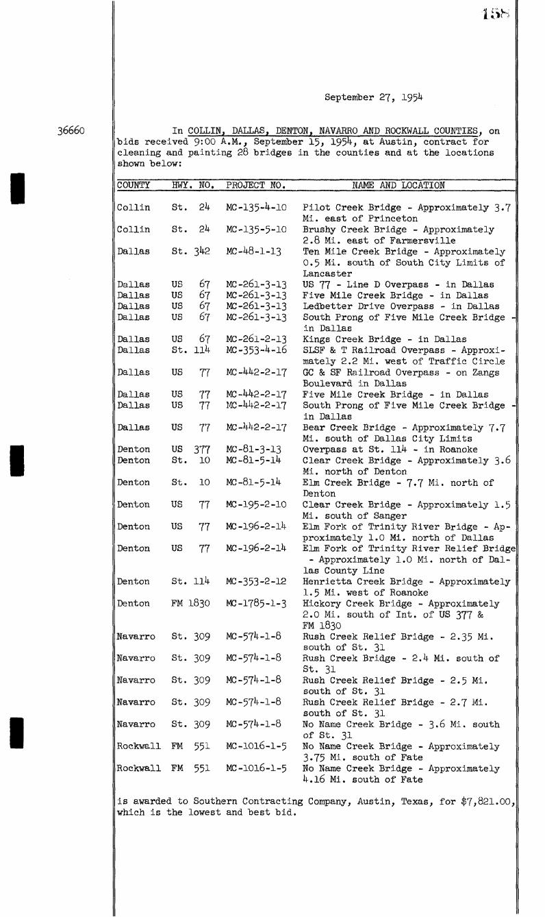
36660
5h
September 27, 1954
In COLLIN, DALLAS, DEBTOR, NAVARRO AND ROCKWALL COUNTIES, on bids received 9:00 A.M., September 15, 1954, at Austin, contract for cleaning and painting 28 bridges in the counties and at the locations shown below:
COUNTY HWY. NO. PROJECT NO. NAME AND LOCATION
Collin
Collin
St. 24
St. 24
MC-135-4-10
MC-135-5-10
Pilot Creek Bridge - Approximately 3«7 Mi. east of Princeton Brushy Creek Bridge - Approximately 2.8 Mi. east of Farmersville Ten Mile Creek Bridge - Approximately 0.5 Mi. south of South City Limits of Lancaster US 77 - Line D Overpass - in Dallas Five Mile Creek Bridge - in Dallas Ledbetter Drive Overpass - in Dallas South Prong of Five Mile Creek Bridge in Dallas Kings Creek Bridge - in Dallas SLSF & T Railroad Overpass - Approximately 2.2 Mi. west of Traffic Circle GO & SF Railroad Overpass - on Zangs Boulevard in Dallas Five Mile Creek Bridge - in Dallas South Prong of Five Mile Creek Bridge in Dallas Bear Creek Bridge - Approximately 7«7 Mi. south of Dallas City Limits Overpass at St. 114 - in Roanoke Clear Creek Bridge - Approximately 3.6 Mi. north of Denton Elm Creek Bridge - 7.7 Mi. north of Denton Clear Creek Bridge - Approximately 1.5 Mi. south of Sanger Elm Fork of Trinity River Bridge - Approximately 1.0 Mi. north of Dallas Elm Fork of Trinity River Relief Bridge - Approximately 1.0 Mi. north of Dal
las County Line Henrietta Creek Bridge - Approximately 1.5 Mi. west of Roanoke Hickory Creek Bridge - Approximately 2.0 Mi. south of Int. of US 377 & FM 1830 Rush Creek Relief Bridge - 2.35 Mi. south of St. 31 Rush Creek Bridge - 2.4 Mi. south of St. 31 Rush Creek Relief Bridge - 2.5 Mi. south of St. 31 Rush Creek Relief Bridge - 2.7 Mi. south of St. 31 No Name Creek Bridge - 3'6 Mi. south of St. 31 No Name Creek Bridge - Approximately 3.75 Mi. south of Fate No Name Creek Bridge - Approximately 4.16 Mi. south of Fate
is awarded to Southern Contracting Company, Austin, Texas, for $7,821.00, which is the lowest and "best bid.
Dallas St. 342 MC-48-1-13
Dallas US 67 MC-261-3-13 Dallas US 67 MC-261-3-13 Dallas us 67 MC-26I-3-I3 Dallas us 67 MC-261-3-13
Dallas us 67 MC-261-2-13 Dallas St. 114 MC-353-4-16
Dallas us 77 MC-442-2-17
Dallas us 77 MC-442-2-17 Dallas us 77 MC-442-2-17
Dallas us 77 MC-442-2-17
Denton us 377 MC-81-3-13 Denton St. 10 MC-81-5-14
Denton St. 10 MC-81-5-14
Denton us 77 MC-195-2-10
Denton us 77 MC-196-2-14
Denton us 77 MC-196-2-14
Denton St. 114 MC-353-2-12
Denton FM 1830 MC-1785-1-3
Navarro St. 309 MC-574-1-8
Navarro St. 309 MC-574-1-8
Navarro St. 309 MC-574-1-8
Navarro St. 309 MC-574-1-8
Navarro St. 309 Me-574-1-8
Rockwall FM 551 MC-1016-1-5
Rockwall FM 551 MC-1016-1-5

36661
36662
36663
36664
5! i
September 27, 1954
In DE WITT COUWTY, on bids received u n t i l 2:00 P.M., September 15, 1954, the contract for construction of an addition to the Dist r i c t Headquarters Building at Yoakum, De Witt County, Job M-13-P-9, i s awarded to R. B. Butler, Inc., P. 0. Box k f l , Bryan, Texas, for $72,260.00, which is the lowest and best bid.
In KAUFMAN COUNTY, on bids received 2:00 P.M., September 2, 1954, at Dallas, contract for repairs to Trinity River Bridge at E l l i s -Kaufman County Line on STATE HIGHWAY 34, Control 173-2-20, Maintenance Project 173-2-20, is awarded to Austin Bridge Company, Dallas, Texas, for $4,405.49, which is the lowest and best bid.
WHEREAS, in ANGELINA COUNTY in the City of Lufkin, an o f f i c i a l request has been made by the City Commission for an extension of STATE HIGHWAY 94 from i t s present terminus at 1st Street to a connection with the U. S. Highway 59 Expressway on the east side of Lufkin; and
WHEREAS, a study of the highway routes at Lufkin, as well as tr a f f i c flow data, indicates the desirability of such an extension;
NOW, THEREFORE, BE IT ORDERED that State Highway 94 in the City of Lufkin be extended from i t s present terminus at 1st Street generally along Dozier Avenue, 4th Street and Lufkin Avenue extended to a connection witb tbe U. S. Highway 59 Expressway, a distance of approximately 0.42 mile; and
IT IS FURTHER ORDERED that upon acceptance of this proposal by the City of Lufkin, surveys and plans be developed covering the improvement of the LUFKIN AVENUE EXTENSION on this designation to provide a pavement approximately 60' in width with a minimum right-of-way of 80' under the standard municipal policy provisions with an estimated State cost of $50,000.00 and estimated local cost of $25,000.00, said project to be brought back to the attention of the Highway Commission for finance when details concerning plans and right-of-way and agreements have been completed; and
IT IS FURTHER ORDERED that said State Highway 94 Extension shall have been completed in accordance with this Order, the G. S. HIGHWAY 69 BUSINESS ROUTE within the City of Lufkin shall be changed to f o l low said State Highway 94 Extension into the downtown area of Lufkin.
This Order is conditioned upon the acceptance of the provisions of same by the City of Lufkin and i f not accepted 120 days from the date of the Order i t shall be automatically cancelled.
WHEREAS, in ATASCOSA COUNTY, STATE HIGHWAY 346 in the vi c i n i t y of the City of Poteet has been constructed on a new location which is remote from the business d i s t r i c t ; and
WHEREAS, i t is desirable to provide the traveling public with a business route through the City of Poteet; and
WHEREAS, the City of Poteet, acting through i t s constituted authorities, has requested that the old route be maintained and marked as a Business Route;
NOW, THEREFORE, IT IS ORDERED that the old route of State Highway 346 which extends from a junction with State Highway 346 northeast of
(Continued on next page)
36664 Con;inued -
36665
36666
36667
September 27, 1954
Poteet through the business d i s t r i c t of Poteet to a junction with State Highway 346 south of Poteet, a distance of approximately 1.7 miles, be and is hereby designated as a BUSINESS ROUTE; and
FURTHER, that this business route shall be eligible for consideration for State maintenance in i t s present condition in conformity with the current maintenance policies of the Department; and
FURTHER, that by this designation the State shall in no way obligate i t s e l f to participate in any reconstruction or major improvement of the existing f a c i l i t i e s ; and
FURTHER, that this Order become effective immediately for the convenience and guidance of the traveling public.
In BEXAR COUNTY, IT IS ORDERED that the portion of Minute Order 34 $84 which authorized the construction of shoulders on LOOP 13 from U.S. Highway 28l north of San Antonio, east a distance of 3*4 miles, at an estimated cost of $30,000.00, be and is hereby cancelled and in l i e u thereof the State Highway Engineer is directed to proceed in the most feasible and economical manner with the following work at the estimated cost as shown:
HWY. LIMITS LENGTH TYPE OF WORK EST. COST
US 0.6 Mi. south of Medina 156' Widen Palo Blanco $ 38,000.00 281 River Cr. Br.
US 11.5 Mi. south of San 826.7' Remove & Replace Rai l 18,200.00 28l Antonio on Medina River Br.
In BOSQUE COUNTY on FARM TO MARKET ROAD 927, from Iredell to Walnut Springs, a distance of approximately 9.6 miles, the condition of Minute Order 32384 having been complied with, the State Highway Engineer is directed to proceed in the most feasible and economical manner with the construction of grading, structures and surfacing, at an estimated cost of $277,500.00.
WHEREAS, in BRAZORIA COUNTY, FARM TO MARKET HIGHWAY l460 has been constructed on new location from a junction with Farm to Market Highway 523 northeast of Velasco, southeasterly to a point southeast of the Intracoastal Waterway; and
WHEREAS, as a result of such construction, the old location of Farm to Market Highway 1460 described as follows is no longer needed for highway purposes:
From the intersection with Farm to Market Highway 523 in Velasco to a point southeasterly of the Intracoastal Waterway, a total distance of approximately hmiles; and
WHEREAS, right-of-way for the construction of Farm to Market Highway 1460 on new location was furnished to the State Highway Department by Brazoria County;
NOW, THEREFORE, IT IS ORDERED BY THE COMMISSION that the above described old location of Farm to Market Highway 1460 be and is hereby released and transferred to Brazoria County; and
(Continued on next page)
36667 Con
36668
36669
36670
36671
1W
September 27, 1954
inued —
FURTHER, that the State Highway Engineer i s directed to notify Brazoria County of this Commission action.
In BRAZORIA COUNTY at ANGLETON, IT IS ORDERED BY THE COMMISSION that the State Highway Engineer he and i s hereby authorized to proceed with the work of constructing a Resident Engineer's Office at an e s t i mated cost of $14,000.00.
WHEREAS, in CALLAHAN AND EASTLAND COGNTIES, STATE HIGHWAY 36 has been constructed on a new location; and
WHEREAS, a portion of the old route w i l l continue to serve a considerable area consisting of small truck farms; and
WHEREAS, Callahan and Eastland Counties have o f f i c i a l l y requested that this portion of the old route, of which approximately 2.8 miles are in Callahan County and 0.9 mile is in Eastland County, be designated a Farm to Market Road with the mileage charged against their respective Farm to Market Road quotas;
NOW, THEREFORE, IT IS ORDERED that the portion of the old route of State Highway 36, which extends from the City of Cross Plains in Callahan County easterly to a junction with State Highway 36 in Eastland County, a distance of approximately 3.7 miles, be and is hereby designated as a FARM TO MARKET ROAD; and
FGRTHER, that the State Highway Engineer i s directed to notify Callahan and Eastland Counties of this Commission action.
In CORYELL COUNTY on STATE HIGHWAY 36, from State Reform School to Hamilton County Line, a distance of approximately 13•3 miles, the reconstruction of grading, structures and surfacing, as authorized by Minute Order 33218, is expected to exceed the original allotment of funds and the State Highway Engineer is directed to proceed with construction of the project as planned, at a revised estimated cost of $397,000.00.
WHEREAS, in DALLAS COUNTY, U.S. HIGHWAY 75 has been constructed on new location from the end of F.I. 832(12) 1948 in Hutchins south to the junction of present G. S. Highway 75 at or near Malloy Bridge Road; and
WHEREAS, as a result of such construction, the section of old U. S. Highway 75 described as follows is no longer needed for highway purposes:
Beginning at the intersection of the old and new locations of U. S. Highway 75 in the City of Hutchins and extending southward to the intersection of the old and new location of U. S. Highway 75 at or near Malloy Bridge Road, a total distance of approximately 7-255 miles; and
WHEREAS, right-of-way for the construction of U. S. Highway 75 on new location was furnished to the State Highway Department by Dallas County;
(Continued on next page)
36671 Corninuea —
36672
36673
36674
36675
IGLf
September 27, 1954
NOW, THEREFORE, IT IS ORDERED by the Commission that the ahove described section of old highway be and is hereby released and transferred to Dallas County; and
FURTHER, that the State Highway Engineer is directed to notify Dallas County of this Commission action.
In FALLS COUNTY on STATE HIGHWAY 7 from State Highway 320 west of the Brazos River to Marlin, a distance of approximately 4.0 miles, recent preliminary studies have indicated the need for major improvements as soon as funds are avilable and the State Highway Engineer i s directed to make location surveys and furnish the local authorities with deeds for a minimum of 120' right-of-way with request that right-of-way be secured for the ultimate construction of a two lane f a c i l i t y at an estimated cost of #00,000.00.
The purpose of this Minute is to provide for advance planning and protection of right-of-way required for proposed improvements with the understanding that funds are not presently available for construction. It i s anticipated, however, that funds w i l l be allocated from future programs of work for the construction of this section in proper sequence with other needed construction work.
In JACKSON COUNTY on U. B. HIGHWAY 59, IT IS ORDERED that the portion of Minute Order 34614, which authorized the construction of shoulders from Edna east 1.0 mile, at an estimated cost of $14,800.00, he and is hereby cancelled and in li e u thereof the State Highway Engineer is directed to proceed in the most feasible and economical manner with the construction of shoulders on G. S. Highway 59 from 4 miles west of E l Toro to the Victoria County Line, a distance of approximately 0.8 mile, at an estimated cost of $14,800.00.
WHEREAS, in JEFF DAVIS COGNTY, Commission Minute Order 36459, dated August 23, 1954, provided for maximum speeds on the section of
G. S. HIGHWAY 90 from Station 949 / 62, C 20-4, southerly through Valentine (unincorporated) to Station 1006 / 29, C 20-5, a distance of 1.07 miles approximately; and
WHEREAS, the City of Valentine is incorporated and has the authority to regulate the speeds on this section of highway;
NOW, THEREFORE, IT IS ORDERED BY THE STATE HIGHWAY COMMISSION that the part of Commission Minute Order 36459 vhich established the speed limits on the above described section of G. 8. Highway 90 be cancelled.
WHEREAS, in JEFFERSON COUNTY, at and near the City of Port Arthur, the old route of U. S. HIGHWAY 96 was abandoned to Jefferson County when the new route was established and b u i l t between Port Arthur and Beaumont; and
WHEREAS, later t r a f f i c developed to such a degree that Jefferson County approached the Highway Commission with the proposal that the old route be redesignated as a State Highway and taken back into the State Highway System for maintenance; and
(Continued on next page)
36675 Con;irmed —
36676
36677
36678
163
September 27, 1954
WHEREAS, the Highway Commission granted this request and designated the route as STATE HIGHWAY 347; and
WHEREAS, the portion of said route in the City of Port Arthur was generally satisfactory for t r a f f i c at that time, said existing route was marked as State Highway 3^7; and
WREREAS, t r a f f i c has now developed to a degree making i t advisable to modify the description of the route at Port Arthur;
NOW, THEREFORE, BE IT ORDERED that the route of STATE HIGHWAY 347 in Port Arthur be revised to follow Stadium Road between Twenty-F i f t h Street and the intersection with State Highway 87 at Sixteenth Street, and the State Highway Engineer is hereby directed to prepare this route for marking and signing in order that State Highway 3 7 traff i c may be transferred to this new route effective December 15, 1954, at which time the section of the present highway within the City of Port Arthur shall be automatically relinquished to the local government unit.
In JIM HOGG COUNTY, at Hebbronville, IT IS ORDERED BY THE COMMISSION that an appropriation in the amount of $3,600.00 be and is hereby made to cover the cost of purchasing approximately five acres of land from Julian R. Cantu for a warehouse site on State Highway 285.
WHEREAS, in KERR COUNTY, FARM TO MARKET HIGHWAY 689 in the v i c i n i t y of Turtle Creek has been constructed on new location; and
WHEREAS, as a result of such construction, the section of old Farm to Market Highway 689 described as follows i s no longer needed for higbway purposes:
Beginning at the intersection of the old and new locations of Farm to Market Highway 689 at approximately Station 309 / 70 on the new location and extending in a southerly direction to another junction of the old and new locations of Farm to Market Highway 689 at approximately Station 355 / 24 on the new location, a distance of 0.77 mile; and
WHEREAS, right-of-way for the construction of Farm to Market Highway 689 on new location was furnished to the State Highway Department by Kerr County;
NOW, THEREFORE, IT IS ORDERED BY THE COMMISSION that the above described section of old highway be and is hereby released and transferred to Kerr County; and
FGRTRER, that the State Highway Engineer is directed to notify Kerr County of this Commission action.
September 28, 1954
WHEREAS, the various laws of the State of Texas set forth certain conditions relating to the employment of persons under the age of seventeen years; and
(Continued on next page)
36678 Con
I 36679
3668O
I
I 3668I
; inued
1G4
September 28, 1954
WHEREAS, in the best interest of the Department i t is desirable that a minimum age for employment be established;
NOW, THEREFORE, IT IS ORDERED by the Commission that effective December 1, 1954, any employee of the Highway Department must be at least seventeen years of age.
In BRISCOE COUNTY, on FARM TO MARKET ROAD 146, from end of existing Farm to Market Road 146, south to original Farm to Market Road 1304, a distance of approximately 5.092 miles, the construction of grading, structures, base and surfacing is expected to exceed the original allotment of funds and the State Highway Engineer is hereby directed to proceed with the work as planned at a revised estimated cost of $148,700
WHEREAS, in EL PASO COUNTY the Texas Highway Department, the City of E l Paso and the County of E l Paso hy Minute Number 35228, wbicb has been accepted by the City and County, have agreed jointly to a proposed plan for the ultimate development of the INTERSTATE ROUTE through and adjacent to the City of E l Paso from Courchesne School to a connection with U. S. Highway 80 near i t s junction with Farm to Market Road 76 near the East City Limits of E l Paso; and
WHEREAS, the City of E l Paso has requested that the Freeway Minute Order Number 35228 be extended from Courchesne School to a point on U. S. Highway 80 north of the Cross Roads at White Spur; and
WHEREAS, the anticipated rapid development of the area requires that immediate steps be taken for the protection of right-of-way required for the ultimate development to Expressway standards along a route to be approved by the State Highway Engineer;
NOW, THEREFORE, IT IS ORDERED by the State Highway Commission that the FREEWAY designation and other pertinent provisions of Minute Number 35228 be extended from Courchesne School to the New Mexico State Line and upon request by the local authorities the State Highway Engineer is directed to furnish the City and County with right-of-way requirements along proposed Interstate route on condition the City of E l Paso w i l l declare the portion of the Interstate route lying within the corporate limits of E l Paso a Freeway in accordance with the provisions of House B i l l 451, 52nd Legislature, and execute the Texas Highway Department's standard forms for construction and maintenance of highway projects i n side incorporated ci t i e s and towns, and with the understanding that a minimum of 300' right-of-way w i l l be required over the entire distance between Courchesne School and the New Mexico State Line with additional widths where needed through rough terrain and at t r a f f i c interchanges; and
FURTHER, that this Minute shall not become operative u n t i l accepted by the proper o f f i c i a l s of the City of E l Paso and i f not accepted within 90 calendar days i t shall become automatically cancelled.
In HARRISON COUNTY on U. S. HIGHWAY 80 from Hallsville to the Louisiana State Line, a distance of approximateiy 32.0 miles, recent pre liminary studies have indicated the need for major improvements as soon as funds are available and the State Higbway Engineer is directed to make
(Continued on next page)

36681 Con ; inued -
36682
36683
36684
36685
1K5
September 28, 1954
location surveys and furnish the local authorities with deeds for a mini mum of 300' right-of-way with request that right-of-way be secured for the ultimate construction of a minimum four-lane f a c i l i t y with controlled access at an estimated cost of $10,000,000.00.
The purpose of this Minute is to provide for advance planning and protection of right-of-way required for proposed Improvements with the understanding that funds are not presently available for construction. I t is anticipated, however, that funds w i l l be allocated from future programs of work for the construction of this section in proper sequence with other needed construction work.
It is understood that this action does not alter or defer any improvements now programmed or authorized for construction on U. S. Highway 80 in the City of Marshall or in Harrison County.
In JASPER COUNTY on FARM TO MARKET ROAD 105, the State Highway Engineer is directed to proceed in the most feasible and economical manner with the installation of automatic grade crossing protective devices at the G. C. & S. F. Railroad crossing at Evadale, at an estimated cost of $7,000.00.
WHEREAS, in McCULLOCH COUNTY, highway planning data indicates the merit of the designation, construction and maintenance of a road extending from Farm to Market Road 503 at Doole, east to U. S. Highway 283 at Fife; and
WHEREAS, the Highway Commission recognizes the importance of such a road as a needed travel f a c i l i t y to serve a large area of West Texas, as well as for local service;
NOW, THEREFORE, IT IS ORDERED that a FARM TO MARKET ROAD be and is hereby designated extending from Farm to Market Road 503 at Doole, east to U. S. Highway 283 at Fife, a distance of approximately I3.6 miles, subject to the condition that a minimum 120 foot right-of-way w i l l be furnished free of cost to the State.
This action is taken in the interest of advance planning with the understanding that funds are not presently available for construction. It i s anticipated that funds w i l l be allotted for construction from future programs of work u n t i l the road is completed in i t s entirety.
At such time as the County shall accept the provisions of this Order and agree to the furnishing of the required right-of-way, the State Highway Engineer is directed to proceed with location surveys, preparation of right-of-way deeds and to turn over such deeds to the County for the securing of the right-of-way.
In McLENNAN COUNTY at Waco, IT IS ORDERED BY THE COMMISSION that an appropriation in the amount of $16,100.00 be and is hereby made to cover the cost of purchasing 8.007 acres of land from W. W. Kethan for a warehouse and Resident Engineer's Office site and District storage area on U. 8. Highway 8k.
In MONTAGUE, CLAY AMD WICHITA COUNTIES, i t is the Intent of the Highway Commission to develop the route of U. S. HIGHWAY 287 from the Wise-Montague County Line to Wichita Falls hy stages to ultimate standard
(Continued on next page)
36685 Con
36686
36687
iw ;
September 28, 1954
inued
of an Expressway to consist of through lanes designed for greatest service and safety to through t r a f f i c , supported by Frontage Roads as required for service to abutting and adjacent areas and for control of access. Control of access to and from abutting and adjacent areas is essential to the function of the f a c i l i t y as an Expressway, and the State Highway Engineer is directed to coordinate future planning, the acquisition of right-of-way, and the control of access under the authority of a Freeway designation as required by House B i l l 451, 52nd Legislature.
WHEREAS, in the following counties, engineering and t r a f f i c investigations have been made to determine the maximum, reasonable, and prudent speeds on the sections of
COUNTY DIST. DESCRIPTION
Morris 19 U. S. HIGHWAY 67 from the East City Limit of Omaha at Station 282 / 82, C 10-8, easterly to Station 256 / 42, C 10-8, a distance of 0.50 mile approximately,
Morris 19 STATE HIGHWAY 26 from the North City Limit of Omaha at Station 34 / 32, 0 85-1, northerly to Station 7l / 81, C 85-1, a distance of O.7l mile app rox imately,
Morris 19 STATE HIGHWAY 26 from the South City Limit of Omaha at Station 36 / 43, C 84-1, southerly to Station 52 / 80, C 84-1, a distance of 0.31 mile approximately,
Gpshur 19 STATE HIGHWAY 26 from Station 1195 / 44, C 392-2, southerly through New Diana (unincorporated) to Station 1225 / 88, C 392-2, a distance of 0.57 mile approximately,
Upshur 19 STATE HIGHWAY 154 from Station 607 / 94, C 402-2, easterly through New Diana (unincorporated) to Station 639 / 62, C 402-2, a distance of 0.60 mile approximately,
as evidenced hy the plans for these zones in the f i l e s of the Texas Highway Department, which are hereby approved; and
WHEREAS, i t has been determined by these engineering and tr a f f i c investigations that the maximum, reasonable, and prudent speeds for the sections of highways described above are as shown on the aforementioned plans;
NOW, THEREFORE, THE STATE HIGHWAY COMMISSION hereby declares and fixes the maximum, reasonable, and prudent speed limits to be as shown on the aforementioned plans; and i t is ordered that the State Highway Engineer be authorized to proceed with the erection of appropriate signs showing the maximum speed limits.
WHEREAS, in NUECES COUNTY in the City of Corpus Chrlsti, agreement has previously been reached between the State Highway Department and the local governmental units relative to the construction of a new multi-lane crossing of U. S. Highway l 8 l at the Corpus Christ! Ship Channel; and
(Continued on next page)

36687 Con ;inued --
1( >«
September 28, 1954
WHEREAS, the location and plans for the development of the Ship Channel crossing project are progressing to a degree that i t is con sidered advisable by a l l of the agencies concerned that advance planning be instituted providing for the ultimate construction of Expressways to properly connect the proposed Channel crossing with existing t r a f f i c generating f a c i l i t i e s so as to serve the orderly accumulation and dispersal of t r a f f i c into and out of the city;
NOW, THEREFORE, the following i n i t i a l proposal i s tendered to the City of Corpus Chrlsti and Nueces County:
The Texas Highway Department w i l l :
1. Provide a l l engineering services necessary for the proper design and construction of the f a c i l i t y within i t s responsi b i l i t y .
2. Finance, contract, supervise and construct grading, drainage, surfacing, grade separation and controlled access f a c i l i t i e s within the limits of the right-of-way provided for the expressway f a c i l i t y , a l l in accordance with the established policies heretofore promulgated by the Highway Commission on f a c i l i t i e s of this type.
3- Upon concurrence with this Order by the local government units, proceed with surveys and preparation of right-of-way data on the sections herein outlined in order that this phase of the advance planning may proceed as rapidly as the local government units desire. The sections of the contemplated expressway system on which advance planning is herein authorized are as follows:
a. On U. S. HIGHWAY l 8 l from the south end of the causeway at Nueces Bay to a connection with the downtown street system and the State Highway 9 Expressway and constituting a l l units necessary for adequate connections to the proposed new crossing on the Corpus Chrlsti Ship Channel,
b. On STATE HIGHWAY 9, relocated and extended to provide for an expressway f a c i l i t y , extending from a connection with Shoreline Boulevard westerly to a point at Port Avenue on State Highway 286,
c. On STATE HIGHWAY 286 and generally in the v i c i n i t y of Port Avenue connecting the State Highway 9 Expressway described above with the State Highway kk Expressway as hereinafter described,
d. On STATE HIGHWAY kk, relocated and extended, from a point of connection with Shoreline Boulevard or i t s projection and extending westerly to an intersection and connection with the State Highway 286 Expressway described above;
Provided the City of Corpus Ohristi and Nueces Oounty w i l l : "
1. Declare the portions of the described routes lying within the corporate limits of Corpus Chrlsti as Freeways in accordance with the provision of House B i l l 451, 52nd Legis-
(Continued on next page)
1KH
36687 Confirmed —
36688
36689
September 28, 1994
lature, and execute the Texas Highway Department's standard form for construction and maintenance of highway projects inside incorporated cities and towns,
2. Furnish free of cost to the State and clear of obstructions and encumbrances necessary right-of-way as may be determined upon completion of surveys and design studies generally estimated to be approximately 26k' with an absolute minimum of 220' and additional areas where necessary at major interchanges, etc.
This Order constitutes a tentative proposal for the f i r s t i n crement of advance planning work as a basis for future formal agreements Upon acceptance by the City of Corpus Christi and the County of Nueces, the State Highway Engineer is directed to proceed with the planning operations herein outlined. Ultimate finance and construction w i l l be covered by a formal agreement duly executed by the o f f i c i a l s of the local government units and the Highway Department.
This Order shall become automatically cancelled 180 days from this date unless i t shall have become operative by the acceptances herein provided.
WHEREAS, in the following county, an engineering and t r a f f i c investigation has "been made to determine the maximum, reasonable, and prudent speed on the sections of
COUNTY DIST. DESCRIPTION ZONE SPEEI
Panola 19 STATE HIGHWAY 149 from the North City 30 Limit of Carthage northwesterly for a distance of 0.75 mile approximately, and from a point 4.25 miles northwest of the North City Limit of Carthage to a point 6.75 miles northwest of the North City Limit of Carthage, a distance of 2.50 miles approximately,
where a construction project is in progress; and
WHEREAS, i t has been determined by this engineering and t r a f f i c investigation that the maximum, reasonable, and prudent speed on the sections of highway described herein is as tabulated under the heading, "Zone Speed;"
NOW, THEREFORE, THE STATE HIGHWAY COMMISSION hereby declares and fixes the maximum, reasonable, and prudent speed limit on the sections of highway described herein to be as tabulated under the heading, "Zone Speed;" and i t is ordered that the State Highway Engineer be author ized to proceed with the erection of appropriate signs showing the maximum speed limit as tabulated under the heading, "Zone Speed." Upon completion of the construction project, a l l such signs shall be removed. The completion and/or acceptance of the project shall cancel the provisions of this Minute.
WHEREAS, proper service to the traveling public indicates the desirability of an Information Bureau at or near the City of Amarillo;and
(Continued on next page)

1 ^
Septembers 1954
36689 Oon^inued --
WHEREAS, tbe Oity and Oonnty are now in tne process of securing rigbt-of-way for tbe Expressway tbrongb tbe Oity, and i t would be in order to secure rigbt-of-way for sucb information Bureau at tbis time;
WOW, THEREFORE, IT IS ORDERED by tbeRigbwayOommissiontbat tbe State Rigbway Engineer be directed to investigate tbe possibility of sucb an information Bureau location and i f a suitable site is found tbat maybe provided to tbe Department witbout cost, tbe State Rigbway Engineer is directed to bring tbis matter back to tbe Oommission for approval and financing of improvements.
36690 InSMlTRAWDOREROKEEOORWTlESonR. S. RiORWAy 69, fromState Rigbway 110 in Tyler, soutb to 2.5 miies soutb of Bullard, a distance of approximately 15.6 miles, tbe State Rigbway Engineer is directed to proceed in tbe most feasible and economical manner witb tbe construction of grading and structures, at an estimated cost of $545,000.00, and to i n clude tbe project in tbe 1955 and 1956 Consolidated Rigbway Program for finance.
3669i WHEEEAS, inTAEEA^^^ circumferential t r a f f i c is nov served on tne nortb and vest by State Highvay 183 and v i l l b e served in tne fntnre in tne southvest area hy loon 217 extending fromO. S. Highvay 377 toO. S. Highvay 8 l ; and
WHEHEAS, i t nov appears desirahie to inaugurate advance planning on a similar type of circumferential t r a f f i c service f a c i l i t y in the southeast and northeast areas of the metropolitan area; and
WHEHEAS, such advance planning vould permit the gradual acquisition of rights-of-vay as development taxes place in the eastern area in order that such routing and right-of-vay vould he available vhen and i f funds vould permit construction on same;
WOW, THEHEEOHE, HE1T0H0EHE0 tbat EOOE 217, presently extending fromO. S. Highvay 377 in the vesternportion of Eort Worth to 0. S. Highvay 81 in the southernportion of Eort Worth, he extended fromO. S. Highvay 81 in the southportion of Eort Worth to 0. S. Highvay 80 in the eastern portion of Eort Worthand thence to a proper intersection vith State Highvay 183 and/or 121 as proper engineering planning may dictate. The State HlghvayEnglneer is directed to furnish advance planning information to the local government units in order that a minimum 3^0' vidth rlght-of-vay may he reserved contemplating construction of a four-lane controlled access f a c i l i t y at some future date vhen funds shallhecome available.
36692 WHEREAS, in TRAVIS OOORTYat and near tbe Oity of Austin on 0. S, RIGRWAY 8 i , expressway constrnction nas been completed from tne nortb into tbe Oity of Anstin to 17tb Street and i s nowunder constrnction or financed from 1st Street to tbe connection witbR. S. Rigbway 8i on tbe sontb; and
WREREAS, tbe sectionbetween 17tb Street and 1st Street in tbe Oity of Anstin w i l l soon prove inadequate for tbe t r a f f i c anticipated on ibis route, making i t necessary to provide f a c i l i t i e s to accommodate tbe additional t r a f f i c ioad;
(Continued on next page)
36692 Con
36693
36694
1 ? U
September 28, 1954
inued
NOW, THEREFORE, BE IT ORDERED that advance planning be inaugur ated on that portion of the U. S. Highway 8l route through the City of Austin on what is known as East Avenue between 17th Street and 1st Street and that coordination be maintained in such planning with the government of the City of Austin in order that this information may be available to said unit of government to enable them to properly protect any additiona l right-of-way that may be needed. It is anticipated in this advance planning that the cost of construction of an adequate t r a f f i c f a c i l i t y on this section of a length of 1.1 miles is $1,500,000.00 contemplating f u l l express construction with control of access.
This Order constitutes a tentative proposal for the f i r s t i n crement of advance planning work as a basis for future formal agreements Upon acceptance by the City of Austin, the State Highway Engineer is directed to proceed with the planning operations herein outlined. U l t i mate finance and construction w i l l be covered by a formal agreement duly executed by the o f f i c i a l s of the local government unit and the Highway Department.
In TRAVIS AND WILLIAMSON COUNTIES on U. B. HIGHWAY 8l from 3.8 miles south of the Travis-Williamson County Line to the Williamson-Bell County Line, a distance of approximately 30.0 miles, the Highway Commission hy Minute Number 32115 having declared an intention to develop this section to ultimate standards of a Freeway and recent preliminary studies having indicated the need for major improvements as soon as funds are available, the State Highway Engineer is directed to make location surveys and furnish the local authorities with deeds for a minimum of 300' right-of-way with request that right-of-way be secured for the ultimate construction of a minimum four-lane f a c i l i t y with controlled access at an estimated cost of $7,000,000.00.
The purpose of this Minute is to provide for advance planning and protection of right-of-way required for proposed improvements with the understanding that funds are not presently available for construction. It is anticipated, however, that funds w i l l be allocated from future programs of work for the construction of this section in proper sequence with other needed construction work.
WHEREAS, in the following county, an engineering and t r a f f i c investigation has "been made to determine the maximum, reasonable, and prudent speed on the section of
COUNTY DIST. DESCRIPTION ZONE SPEEI
Wharton 13 U. S. HIGHWAY 59 from Station 395 / 00, 45 0 89-6-10, easterly to Station 656 / 65, C 89-6-IO, a distance of 4.955 miles approximately,
where a construction project is in progress; and
WHEREAS, i t has been determined by this engineering and t r a f f i c investigation that the maximum, reasonable, and prudent speed on the sec tion of higbway described herein is as tabulated under the heading, "Zone Speed;"
(Continued on next page)

171
36694 Con
I 36695
I 36696
36697
I 36698
September 28, 1954
inued --
NOW, THEREFORE, THE STATE HIGHWAY COMMISSION hereby declares and fixes the maximum, reasonable, and prudent speed limit on the section of highway described herein to be as tabulated under the heading, "Zone Speed;" and i t is ordered that the State Highway Engineer be authorized to proceed with the erection of appropriate signs showing the maximum speed lim i t as tabulated under the heading, "Zone Speed." Upon completion of the construction project, a l l such signs shall be removed. The completion and/or acceptance of the project shall cancel the provisions of this Minute.
In WHARTON AND FORT BEND COUNTIES on U. S. HIGHWAY 59 from a point west of the Colorado River at Wharton to a point east of the Brazos River at Richmond, a distance of approximately 32.0 miles, recent preliminary studies have indicated the need for major improvements as soon as funds are available and the State Highway Engineer is directed to make location surveys and furnish the local authorities with deeds for a minimum of 300' right-of-way with request that right-of-way be secured for the ultimate construction of a minimum four-lane f a c i l i t y with controlled access at an estimated cost of $12,000,000.00.
The purpose of this Minute is to provide for advance planning and protection of right-of-way required for proposed improvements with the understanding that funds are not presently available for construction. It i s anticipated, however, that funds w i l l be allocated from future programs of work for the construction of this section in proper sequence with other needed construction work.
In WILBARGER AND WICHITA COUNTIES on U. S. HIGHWAY 28? from Vernon to Wichita F a l l s , a distance of approximately 50.0 miles, recent preliminary studies have indicated the need for major improvements as soon as funds are available and the State Highvay Engineer is directed to make location surveys and furnish the local authorities with deeds for a minimum of 300' right-of-way with request that right-of-way be secured for the ultimate construction of a minimum four-lane f a c i l i t y with controlled access at an estimated cost of $15,000,000.00.
The purpose of this Minute is to provide for advance planning and protection of right-of-way required for proposed improvements with the understanding that funds are not presently available for construction. It i s anticipated, however, that funds w i l l be allocated from future programs of work for the construction of this section in proper sequence with other needed construction work.
In WILSON AND KARNES COUNTIES, on U. S. HIGHWAY l 8 l , from 2.0 miles southeast of Floresville to 0.12 mile southeast of Karnes County Line, a distance of approximately 10.213 miles, the construction of grading, structures, base and surfacing i s expected to exceed the origi n a l allotment of funds and the State Highway Engineer is hereby directed to proceed with the work as planned at a revised estimated cost of $518,000.00.
In KNOX, FOARD, AND BAYLOR COUNTIES, IT IS ORDERED that the time limit set in Minute No. 36168 be extended sixty days, in order that additional consideration may be given to this problem.
-45 > I / *-
,( r'
September 29, 1954
36699 WHEREAS, on September 28, 1954, a representative group of c i t -izens from Wichita Falls and WICHITA COUWTY appeared before the State Highway Commission of Texas and requested assurance that the Texas Highway Department would construct from Wichita Falls to the middle of the Red River, a four-lane divided highway and bridge, to meet a similar f a c i l i t y proposed to be b u i l t to tbe Red River by the Oklahoma Turnpike Authorityj and
WHEREAS, i t i s believed that, for such a f a c i l i t y to be successfully operated from the standpoint of t r a f f i c , i t would require an adequate f a c i l i t y in and through the City of Wichita Falls for convenient origin or dispersal of said t r a f f i c ; and
WHEREAS, the Texas Highway Department has no authority to build or to assist in building any type or any part of a highway f a c i l i t y on which a t o l l or any other form of tax is levied against t r a f f i c desiring to enter upon, travel over, or exit from such f a c i l i t y ;
NOW, THEREFORE, i f right-of-way for an adequate f a c i l i t y in and through Wichita Falls and thence to the Red River is promptly secured, and i f adequate t o l l free f a c i l i t i e s from the proposed new Red River bridge northward along Highways 28l and 277 are assured, the Texas Highway Department w i l l participate f i f t y - f i f t y in the cost of a new toll-free bridge across the Red River and w i l l complete an adeuqate four-lane divided highway from Wichita Falls to the proposed new Red River Bridge not later than the time the proposed Oklahoma t o l l road is ready for operation.
36700 WHEREAS, in WASHINGTON COUWTY, at the request of the local units of government, Minute Order No. 31666, dated February 20, 1952, directed that a study be made of higbway routings at Brenham; and
WHEREAS, this study has been completed and carefully analyzed;
NOW, THEREFORE, BE IT ORDERED that a LOOP OR BELT route be bereby designated, extending from a point on State Highway 36 north of Brenham to U. S. Highway 290 west of Brenham, thence to State Highway 36 and U. S. Highway 290 south and east of Brenham, and the State Highway Engineer is directed to proceed with location surveys and preparation of right-of-way information, based upon a 300' minimum width, in order that the local government units may proceed with the securing of the necessary right-of-way for the proposed improvement, and the State Highway Engineer is directed to report back to the Highway Commission for consideration of finance at such time as right-of-way shall have been secured in accordance with the provisions of this Order.
This Order shall become effective at such time as appropriate resolutions may be received from the City of Brenham and the County of Washington, expressing concurrence in the intent of this Order and tendering necessary cooperation in the securing of right-of-way. In case the provisions of this Order are not accepted by both government units by January 1, 1955, this Order shall be automatically cancelled.
36701 In ANDREWS COUNTY on FARM TO MARKET ROAD 703, from Winkler County Line to Andrews, a distance of approximately 2k.k miles, the State Highway Engineer i s directed to proceed in the most feasible and economical manner with the reconstruction of grading, structures and surfacing, at an estimated cost of $205,000.00.
36702
36703
36704
173
September 29, 1954
WHEREAS, in ARCHER COUNTY, a study of the most needed road improvements has been made and consultations have been held with the appropriate County o f f i c i a l s relative to the road needs of the County;
NOW, THEREFORE, IT IS ORDERED that the following be designated as FARM TO MARKET ROADS, subject to the condition that Archer County w i l l furnish a l l required right-of-way free of cost to the State:
From U. S. Highway 28l at Windthorst, east to Clay County Line, a distance of approximately 1.0 miles.
From Farm to Market Road 1954, 2.5 miles east of Farm to Market Road 368, southeast to State Highway 79, a distance of approximately 5.3 miles.
From Archer City southeast, a distance of approximately 5.9 miles.
At such time as the County shall accept the provisions of this Order and agree to the furnishing of the required right-of-way, the State Highway Engineer is directed to proceed with the engineering development and construction of the projects in the most feasible and economical man ner, at an estimated cost of $188,100.00, and to assume the roads for State maintenance upon completion of the construction herein authorized.
In case right-of-way agreement by the County is not executed within 120 days of the date of this Order, the action herein contained shall be automatically cancelled.
WHEREAS, in AUSTIN COUNTY, a study of the most needed road improvements has been made and consultations have been held with the appropriate County o f f i c i a l s relative to the road needs of the County;
NOW, THEREFORE, IT IS ORDERED that the following be designated as FARM TO MARKET ROADS, subject to the condition that Austin County w i l l furnish a l l required right-of-way free of cost to the State:
From end of Farm to Market Road 2142, 5.5 miles northwest of Sealy, northwest to Farm to Market Road 1088, a distance of approximately 6.0 miles.
From Wallis west to Wharton County Line, a distance of approximately 4.9 miles.
At such time as the County shall accept the provisions of this Order and agree to the furnishing of the required right-of-way, the State Highway Engineer is directed to proceed with the engineering development and construction of the projects in the most feasible and economical man. ner, at an estimated cost of $378,900.00, and to assume the roads for State maintenance upon completion of the construction herein authorized.
In case right-of-way agreement by the County is not executed within 120 days of the date of this Order, the action herein contained shall be automatically cancelled.
WHEREAS, in BASTROP COUNTY, a study of the most needed road improvements has been made and consultations have been held with the appropriate County o f f i c i a l s relative to the road needs of the County;
(Continued on next page)

36704 Continued —
36705
36706
September 29, 1954
NOW, THEREFORE, IT IS ORDERED that the following be designated as FARM TO MARKET ROADS, subject to the condition that Bastrop County w i l l furnish a l l required right-of-way free of cost to the State:
From State Highway 21 at Cedar Creek southeast to Farm to Market Road 20 near Rockne, a distance of approximately 8.0 miles.
From end of Farm to Market Road 2104 south of Paige, east to Lee County Line, a distance of approximately 2.0 miles.
At such time as the County shall accept the provisions of this Order and agree to the furnishing of the required right-of-way, the State Highway Engineer is directed to proceed with the engineering development and construction of the projects in the most feasible and economical manner, at an estimated cost of $183,100.00, and to assume the roads for State maintenance upon completion of the construction herein authorized.
In case right-of-way agreement by the County is not executed within 120 days of the date of this Order, the action herein contained shall be automatically cancelled.
WHEREAS, in BLANCO COUNTY, a study of the most needed road improvements has heen made and consultations have "been held with the appropriate County o f f i c i a l s relative to the road needs of the County;
NOW, THEREFORE, IT IS ORDERED that the following be designated as RANCH TO MARKET ROADS, subject to the condition that Blanco County w i l l furnish a l l required right-of-way free of cost to the State:
From end of Farm to Market Road 1623, 10.2 miles northwest of Blanco, northwest to Gillespie County Line, a distance of approximately 3-3 miles.
From end of Farm to Market Road 1320 northeast to Farm to Market Road 1824 at Sandy, a distance of approximately 4.9 miles.
At such time as the County shall accept the provisions of this Order and agree to the furnishing of the required right-of-way, the State Highway Engineer i s directed to proceed with the engineering development and construction of the projects in the most feasible and economical manner, at an estimated cost of $85,500.00, and to assume the roads for State maintenance upon completion of the construction herein authorized.
In case right-of-way agreement by the County is not executed within 120 days of the date of this Order, the action herein contained shall be automatically cancelled.
WHEREAS, in BORDEN COUNTY, a study of the most needed road improvements has heen made and consultations have been held with the appropriate County o f f i c i a l s relative to the road needs of the County;
NOW, THEREFORE, IT IS ORDERED that a FARM TO MARKET ROAD be des ignated, extending from Farm to Market Road 1957, east to end of Farm to Market Road l6l0, at Scurry County Line, a distance of approximately 2.8 miles, subject to the condition that Borden County w i l l furnish a l l required right-of-way free of cost to the State.
(Continued on next page)
36706 Con
I
36707
I
36708
I
17f
September 29, 1954
inued
At such time as the County shall accept the provisions of this Order and agree to the furnishing of the required right-of-way, the State Highway Engineer is directed to proceed with the engineering development and construction of the project in the most feasible and economical manner, at an estimated cost of $28,000.00, and to assume the road for State maintenance upon completion of the construction herein authorized.
In case right-of-way agreement by the County is not executed within 120 days of the date of this Order, the action herein contained shall be automatically cancelled.
WHEREAS, in BRAZORIA COUNTY, a study of the most needed road improvements has been made and consultations have been held witb the appropriate County o f f i c i a l s relative to the road needs of the County;
NOW, THEREFORE, IT IS ORDERED that the following be designated as FARM TO MARKET ROADS, subject to the condition that Brazoria County w i l l furnish a l l required right-of-way free of cost to the State:
From Farm to Market Road 523 northwest to State Highway 288, a distance of approximately 3.4 miles.
From State Highway 35 northeast via Anchor to State Highway 288, a distance of approximately 10.8 miles.
At such time as the County shall accept the provisions of this Order and agree to the furnishing of the required right-of-way, the State Highway Engineer i s directed to proceed with the engineering development and construction of the projects in the most feasible and economical manner, at an estimated cost of $477,800.00, and to assume the roads for State maintenance upon completion of the construction herein authorized.
In case right-of-way agreement by the County is not executed within 120 days of the date of this Order, the action herein contained shall be automatically cancelled.
WHEREAS, in BREWSTER COUNTY, a study of the most needed road improvements has heen made and consultations have been held vith the appropriate County o f f i c i a l s relative to the road needs of the County:
NOW, THEREFORE, IT IS ORDERED that a RANCH TO MARKET ROAD be designated, extending from U. S. Highvay 90 approximately 2.0 miles east of Marathon northeast to Pecos County Line, a distance of approximately 18.0 miles, subject to the condition that Brewster County w i l l furnish a l l required right-of-way free of cost to the State.
At such time as the County shall accept the provisions of this Order and agree to the furnishing of the required right-of-way, the State Highway Engineer is directed to proceed with the engineering development and construction of the project in the most feasible and economical manner, at an estimated cost of $261,500.00, and to assume the road for State maintenance upon completion of the construction herein authorized.
In case right-of-way agreement by the County is not executed within 120 days of the date of this Order, the action herein contained shall be automatically cancelled.
36709
36710
36711
36712
1?*;
September 29, 1954
WHEREAS, in CALDWELL COUNTY, a study of the most needed road improvements has been made and consultations have been held with the appropriate County o f f i c i a l s relative to the road needs of the Countyj
NOW, THEREFORE, IT IS ORDERED that the following be designated as FARM TO MARKET ROADS, subject to the condition that Caldwell County w i l l furnish a l l required right-of-way free of cost to the State:
From State Highway 80 at Martindale to Guadalupe County Line, a distance of approximately 1.1 miles.
From State Highway 80 at Fentress to Guadalupe County Line, a distance of approximately 0.6 mile.
From Farm to Market Road 20 in Lockhart southeast to Farm to Market Road 86 near Brownsboro, a distance of approximately 9-7 miles.
At such time as the County shall accept the provisions of this Order and agree to the furnishing of the required right-of-way, the State Highway Engineer is directed to proceed with the engineering development and construction of the projects in the most feasible and economical manner, at an estimated cost of $172,100.00, and to assume the roads for State maintenance upon completion of the construction herein authorized.
In case right-of-way agreement by the County i s not executed within 120 days of the date of this Order, the action herein contained shall be automatically cancelled.
In CALDWELL COUWTY on STATE HIGHWAY 304, from Bastrop County Line to Gonzales County Line, a distance of approximately 8.5 miles, the State Highway Engineer is directed to proceed in the most feasible and economical manner with the construction of grading, structures and surfacing, at an estimated cost of $133*000.00.
WHEREAS, in CALHOUN COUNTY, a study of the most needed road improvements has been made and consultations have been held with the appropriate County o f f i c i a l s relative to the road needs of the County;
NOW, THEREFORE, IT IS ORDERED that a FARM TO MARKET ROAD be designated, extending from State Highway 35, 4.2 miles west of Port Lavaca, southwest to County road, a distance of approximately 3.4 miles, subject to the condition that Calhoun County w i l l furnish a l l required right-of-way free of cost to the State.
At such time as the County shall accept the provisions of this Order and agree to the furnishing of the required right-of-way, the State Highway Engineer is directed to proceed with the engineering development and construction of the project in the most feasible and economical manner, at an estimated cost of $79,000.00, and to assume the road for State maintenance upon completion of the construction herein authorized.
In case right-of-way agreement by the County is not executed within 120 days of the date of this Order, the action herein contained shall be automatically cancelled.
In CALLAHAN COUNTY on U. S. HIGHWAY 380, from Shackelford County Line to Eastland County Line, a distance of approximately 2.7 miles, the State Highway Engineer is directed to proceed in the most feasible and economical manner with the construction of grading, structures and surfacing, at an estimated cost of $118,000.00.
36713
I
36714
I
36715
36716
I
17
September 29, 1954
WHEREAS, in CALLAHAN COUNTY, a study of the most needed road improvements has been made and consultations have been held vith the appropriate County o f f i c i a l s relative to the road needs of the County;
NOW, THEREFORE, IT IS ORDERED that a FARM TO MARKET ROAD be designated, extending from U. S. Highvay 80, 5 miles east of Baird, south to road intersection, a distance of approximately 3.5 miles, subject to the condition that Callahan County v i l l furnish a l l required right-of-vay free of cost to the State.
At such time as the County shall accept the provisions of this Order and agree to the furnishing of the required right-of-vay, the State Highvay Engineer is directed to proceed with the engineering development and construction of the project in the most feasible and economical manner, at an estimated cost of $60,000.00, and to assume the road for State maintenance upon completion of the construction herein authorized.
In case right-of-vay agreement by the County is not executed vithin 120 days of the date of this Order, the action herein contained shall be automatically cancelled.
WHEREAS, in CHAMBERS COUWTY, a study of the most needed road improvements has been made and consultations have been held with the appropriate County o f f i c i a l s relative to the road needs of the County;
WOW, THEREFORE, IT IS ORDERED that a FARM TO MARKET ROAD be designated, extending from end of Farm to Market Road 1985, 3-3 miles east of Farm to Market Road 562, east to State Highway 124, a distance of approximately 11.7 miles, subject to the condition that Chambers County w i l l furnish a l l required right-of-way free of cost to the State.
At such time as the County shall accept the provisions of this Order and agree to the furnishing of the required right-of-way, the State Highway Engineer is directed to proceed with the engineering development and construction of the project in the most feasible and economical manner, at an estimated cost of $202,700.00, and to assume the road for State maintenance upon completion of the construction herein authorized.
In case right-of-way agreement by the County is not executed within 120 days of the date of this Order, the action herein contained shall be automatically cancelled.
In CHAMBERS COUNTY on FARM TO MARKET ROAD 563, from 2.7 miles south of Liberty County Line to Turtle Bayou, a distance of approximately 2.6 miles, the State Highway Engineer is directed to proceed in the most feasible and economical manner with the construction of grading, structures and surfacing, at an estimated cost of $101,000.00.
WHEREAS, in CLAY COUNTY, a study of the most needed road improvements has been made and consultations have been held with the appro-priate County o f f i c i a l s relative to the road needs of the County;
NOW, THEREFORE, IT IS ORDERED that the following be designated as FARM TO MARKET ROADS, subject to the condition that Clay County w i l l furnish a l l required right-of-way free of cost to the State:
From end of Farm to Market Road 175, southwest to Jack County Line, a distance of approximately 2.9 miles.
(Continued, on next page)
36716 Oon
367i7
36718
1^
September 29, 1954
inued —
From Archer Oonnty Line east of Windthorst, east to State Highway!^, adistance of approximately 13-3 miles.
At such time as the Oonnty shaii accept the provisions of this Order and agree to the furnishing of the required right-of-way, the State Highway Engineer is directed to proceed with the engineering development and constrnction of the projects in the most feasihle and economical man ner, at an estimated cost of $226,900.00, and to assume the roads for State maintenance upon completion of the construction herein authorized.
In case right-of-way agreement hy the Oounty is not executed within i20 days of the date of this Order, the action herein contained shall he automatically cancelled.
in COLEMAN OOUNTY, a study o i the most needed road improvements has heen made and oonsuitations have heen heid with the appropriate Oounty o i f i o i a i s relative to the road needs of the Oounty;
^ 0 ^ TRER FORE IT 18 ORI^RER that a FARM TO MARKET ROAR he designated, extending irom end o i Farm to Market Road 21^1, 4^ miles sonth o i Ooleman, sonth to Shields and east to O. 8. Righway 28^, a distance of approximately 15.0 miies, suhject to the condition that Ooleman Oonnty w i i i furnish a i i required right-of-way free of cost to the State.
At snch time as the Oonnty shaii accept the provisions of this Order and agree to the furnishing of the required right-of-way, the 8tate Righvay Engineer i s directed to proceed with the engineering development and construction of the project i n the most feasihie and economical manner, at an estimated cost of $210,000.00, and to assume the road for 8tate maintenance upon completion of the construction herein authorized.
In case right-of-way agreement hy the Oounty i s not executed within 120 days of the date of this Order, the action herein contained shall he automatically cancelled.
^880^8, i n OOMANORE OOONTY a study of the most deeded road improvements nas been made and consultations nave heen heid with the appropriate Oonnty o f f i c i a l s relative to the road needs o i the Oonnty;
NOW, THEREFORE, iT i8 ORDERED that the following he designated as EARM TO MARKET R0AD8, suhject to the condition that Oomanche Oounty w i i i fnmish a i i required right-of-way free of cost to the 8tate:
Erom Oomanche, north to Oonnty Road, a distance of approximateiy i2.0 miies.
Erom 8tate Righway 36, 4 ^ i i e s east of Onstine, southwest to Energy, a distance of approximateiy 6.5 miies.
At such time as the Oounty shaii accept the provisions of this Order and agree to the furnishing of the required right-of-way, the 8tate Righway Engineer i s directed to proceed with the engineering development and construction of the projects i n the most feasihie and economical man ner, at an estimated cost of $2^2,000.00, and to assume the roads for 8tate maintenance upon completion of the construction herein authorized.
i n case right-of-way agreement hy the Oounty i s not executed within i20 days of the date of this Order, the action herein contained shaii he automatically canceiied.
1'7I)
September 29, 1954
WHEREAS, in COOKE COUNTY, a study of the most needed road improvements has been made and consultations have been held vith the appropriate County o f f i c i a l s relative to the road needs of the County;
NOW, THEREFORE, IT IS ORDERED that the folloving be designated as FARM TO MARKET ROADS, subject to the condition that Cooke County v i l l furnish a l l required right-of-vay free of cost to the State:
From end of Farm to Market Road 372, east and south to Denton County Line, a distance of approximately 4.0 miles.
From end of Farm to Market Road 678 at Hope, east and north to U. S. Highvay 82, a distance of approximately 7.7 miles.
Erom end of Farm to Market Road 373, 4.5 miles north of Muenster, north to road intersection, a distance of approximately 5.4 miles.
At such time as the County shall accept the provisions of tbis Order and agree to the furnishing of the required right-of-vay, the State Highvay Engineer is directed to proceed vit h the engineering development and construction of the projects in the most feasible and economical manner, at an estimated cost of $246,500.00, and to assume the roads for State maintenance upon completion of the construction herein authorized.
In case right-of-way agreement by the County i s not executed vithin 120 days of the date of this Order, the action herein contained shall be automatically cancelled.
In CRANE COUNTY on FARM TO MARKET ROAD 870, from Crane east to Upton County Line, a distance of approximately 2.2 miles, the State Highway Engineer i s directed to proceed in the most feasible and economi c a l manner with the reconstruction of grading, structures, and surfacing at an estimated cost of $22,000.00.
WHEREAS, in De WITT COUNTY, a study of the most needed road improvements has heen made and consultations have heen held with the appropriate County o f f i c i a l s relative to the road needs of the County;
NOW, THEREFORE, IT IS ORDERED that a FARM TO MARKET ROAD be designated, extending from Farm to Market Road 240 east to U. S. Highway 87, 9 miles northwest of Cuero, a distance of approximately 5.4 miles, subject to the condition that De Witt County w i l l furnish a l l required right-of-way free of cost to the State.
At such time as the County shall accept the provisions of this Order and agree to the furnishing of the required right-of-way, the State Highway Engineer is directed to proceed with the engineering development and construction of the project in the most feasible and economical manner, at an estimated cost of $130,000.00, and to assume the road for Statj^ maintenance upon completion of the construction herein authorized.
In case right-of-way agreement by the County is not executed within 120 days of the date of this Order, the action herein contained shall be automatically cancelled.
1 ^
Septemher29, 1954
36722 In DIMMIT CORRTy on EARM TO MARKET R0AD190, theState Righway Engineer is directed to proceed in the most feasihle and economical manner with the construction of Nneces Eiver and Relief Bridges sonth of Rrundage, at an estimated cost of $60,000.00.
36723 WREREAS,in EASTEANDC0ONTy,astudy of the most needed road improvements has heen made and consultations have heen held with the appropriate Connty o f f i c i a l s relative to the road needs of the Connty;
ROW, TREREEORE, IT IS ORDERED thataEARM TO MARKET ROAD he designated, extending from end of Earm to Market Road 57C, 6 miles east of Eastland, east to Earm to Market Road 571 near Chaney, a distance of approximately 7-2 miles, suhject to the condition that Eastland Connty w i l l fnrnish a l l required right-of-way free of cost to the State.
At such time as the County shall accept the provisions of this Order and agree to the furnishing of the required right-of-way, the State RighwayEngineer is directed to proceed with the engineering development and construction of the project in the most feasihle and economical manner, at an estimated cost of $116,000.00, and to assume the road for State maintenance upon completion of the construction herein authorized.
In case right-of-way agreement hy the County is not executed within 120 days of this Order, the action herein contained shall he automatically cancelled.
36724 WREREAS, i n ROTOR OORNTY, a s t u d y of themost needed r o a d i m -provements has heen made and consultations have heen heid with the appropriate Oonnty o f f i c i a l s relative to the road needs of the Oonnty;
NOW, TREREEORE, iT IS OROERER thataEARMTO MARKET ROAR he designated, extending from State Righway 51 north to 0. S. Righway 80 in Odessa, a distance of approximately 3-7 miies, suhject to the condition that Ector Oonnty w i i i furnish a l l required right-of-way free of cost to the State and w i i i provide for the construction of the section within the city limits of Odessa.
At such time as the Oounty shall accept the provisions of this Order and agree to the furnishing of the required right-of-way, the State RighwayEngineer is directed to proceed with the engineering development and construction of the project in the most feasihle and economical manner, at an estimated cost of $75,000.00, and to assume the road for State maintenance upon completion of the construction herein authorized.
in case right-of-way agreement hy the Oounty is not executed within 120 days of the date of this Order, the action herein contained shaiihe automatically cancelled.
36725 WREREAS, inEEEASOOOORTy, astndyof themostneededroadim-provements has heen mane and consultations have heen held with the appropriate Oonnty o f f i c i a l s relative to the roan needs of the Oonnty;
NOW, TREREEORE, IT IS OREEREOthataEARM TO MARKET ROAR for area development he designated, extending fromEoop 16 i n E l Easo east and southeast to Earm to Market Road 659, 3-0 miles north of Ysleta, a distance of approximately 8-0 miles, snhject to the condition that E l
(Continued on next page)
.81
September 29, 1954
Con ;Inued —
Paso County w i l l furnish right-of-way of a minimum 300 feet in width with additional widths as may be required at road crossings or where rough terrain exists, free of cost to the State.
At such time as the County shall accept the provisions of this Order and agree to the furnishing of the required right-of-way, the State Highway Engineer is directed to proceed with the engineering development and construction of the project in the most feasible and economical manner, at an estimated cost of $380,000.00, and to assume the road for State maintenance upon completion of the construction herein authorized.
In case right-of-way agreement by the County is not executed within 120 days of the date of this Order, the action herein contained shall he automatically cancelled.
WHEREAS, in FAYETTE COUNTY, a study of the most needed road improvements has been made and consultations have heen held with the appropriate County o f f i c i a l s relative to the road needs of the County;
NOW, THEREFORE, IT IS ORDERED that the following he designated as FARM TO MARKET ROADS, suhject to the condition that Fayette County w i l l furnish a l l required right-of-way free of cost to the State:
From State Highway 95 at Cistern east to Farm to Market Road 154 at Muldoon, a distance of approximately 10.3 miles.
From end of Farm to Market Road 956 at Freyburg southwest to U. S. Highway 90 at Engle, a distance of approximately 7.5 miles.
At such time as the County shall accept the provisions of this Order and agree to the furnishing of the required right-of-way, the State Highway Engineer is directed to proceed with the engineering development and construction of the projects in the most feasihle and economical manner, at an estimated cost of $325,000.00, and to assume the roads for State maintenance upon completion of the construction herein authorized.
In case right-of-way agreement hy the County is not executed within 120 days of the date of this Order, the action herein contained shall he automatically cancelled.
WHEREAS, in FISHER COUNTY, a study of the most needed road improvements has been made and consultations have been held with the appropriate County o f f i c i a l s relative to the road needs of the County;
NOW, THEREFORE, IT IS ORDERED that the following be designated as FARM TO MARKET ROADS, subject to the condition that Fisher County w i l l furnish a l l required right-of-way free of cost to the State:
From U. S. Highway 180 south of McCaulley southeast to Jones County Line, a distance of approximately 8.9 miles.
From Farm to Market Road 6 l l at Hohhs west to Scurry County Line, a distance of approximately k . l miles.
(Continued on next page)

36727 Confirmed - -
I
36728
I
36729
I
September 29, 195U
At such time as the County shall accept the provisions of this Order and agree to the furnishing of the required right-of-way, the State Highway Engineer is directed to proceed with the engineering development and construction of the projects in the most feasible and economical manner, at an estimated cost of $145,000.00, and to assume the roads for State maintenance upon completion of the construction herein authorized
In case right-of-way agreement by the County i s not executed within 120 days of the date of this Order, the action herein contained shall be automatically cancelled.
WHEREAS, in FORT BEND COUWTY, a study of the most needed road improvements has been made and consultations have been held with the appropriate County o f f i c i a l s relative to the road needs of the County;
NOW, THEREFORE, IT IS ORDERED that the following be designated as FARM TO MARKET ROADS, subject to the condition that Fort Bend County w i l l furnish a l l required right-of-way free of cost to the State:
From Farm to Market Road 361 at Long Point, northeast to Farm to Market Road 762, a distance of approximately 3.9 miles.
From U. S. Highway 59 at Missouri City, southeast to Blue Ridge Prison Farm, a distance of approximately 4.9 miles.
At such time as the County shall accept the provisions of this Order and agree to the furnishing of the required right-of-way, the State Highway Engineer is directed to proceed with the engineering development and construction of the projects in the most feasible and economical manner, at an estimated cost of $264,500.00, and to assume the roads for State maintenance upon completion of the construction herein authorized
In case right-of-way agreement by the County is not executed within 120 days of the date of this Order, the action herein contained shall be automatically cancelled.
WHEREAS, in GILLESPIE COUNTY, a study of the most needed road improvements has heen made and consultations have heen held with the appropriate County o f f i c i a l s relative to the road needs of the County;
NOW, THEREFORE, IT IS ORDERED that a RANCH TO MARKET ROAD he designated, extending from end of Farm to Market Road 783 northeast of Harper, northeast to Farm to Market Road 648 at Doss, a distance of approximately 8.6 miles, suhject to the condition that Gillespie County w i l l furnish a l l required right-of-way free of cost to the State.
At such time as the County shall accept the provisions of this Order and agree to the furnishing of the required right-of-way, the State Highway Engineer i s directed to proceed with the engineering development and construction of the project in the most feasihle and economical manner, at an estimated cost of $83,500.00, and to assume the road for State maintenance upon completion of the construction herein authorized.
In case right-of-way agreement by the County is not executed within 120 days of the date of this Order, the action herein contained shall be automatically cancelled.
36730
I
36731
I 36732
36733
I
i t r t i
September 29, 1954
WHEREAS, in GONZALES COUNTY, a study of the most needed road improvements has been made and consultations have been held with the appropriate County o f f i c i a l s relative to the road needs of the County;
NOW, THEREFORE, IT IS ORDERED that a FARM TO MARKET ROAD be designated, extending from end of Farm to Market Road 1116, 4.5 miles south of State Highway 97, south toward Pilgrim, a distance of approximately 6.2 miles, subject to the condition that Gonzales County w i l l furnish a l l required right-of-way free of cost to the State.
At such time as the County shall accept the provisions of this Order and agree to the furnishing of the required right-of-way, the State Highway Engineer is directed to proceed with the engineering development and construction of the project in the most feasible and economical manner, at an estimated cost of $140,000.00, and to assume the road for State maintenance upon completion of the construction herein authorized.
In case right-of-way agreement by the County is not executed within 120 days of the date of this Order, the action herein contained shall be automatically cancelled.
In GONZALES COGNTY on STATE HIGHWAY 304, from U. S. Highway 90 north to Caldwell County Line, a distance of approximately 3 A miles, the State Highway Engineer is directed to proceed in the most feasible and economical manner with the construction of grading, structures and surfacing, at an estimated cost of $92,600.00.
In HARDIN COUNTY on FARM TO MARKET ROAD 1293, from Farm to Market Road 787 near Thicket, north and east to Bragg, a distance of approximately 5.2 miles, the construction of grading, structures and surfacing, as authorized hy Minute Orders 33275, 35085 and 35083, is expected to exceed the original allotment of funds and the State Highway Engineer is directed to proceed with construction as planned, at a revised cost of $196,700.00.
WHEREAS, in HARDIN COUNTY, a study of the most needed road improvements has heen made and consultations have been held with the appro priate County o f f i c i a l s relative to the road needs of the County;
NOW, THEREFORE, IT IS ORDERED that a FARM TO MARKET ROAD be designated, extending from end of Farm to Market Road 1293 at Bragg, east to road intersection, a distance of approximately 4.5 miles, subject to the condition that Hardin County w i l l furnish a l l required right-of-way free of cost to the State.
At such time as the County shall accept the provisions of this Order and agree to the furnishing of the required right-of-way, the State Highway Engineer is directed to proceed with the engineering development and construction of the project in the most feasible and economical manner, at an estimated cost of $206,700.00, and to assume the road for State maintenance upon completion of the construction herein authorized.
In case right-of-way agreement by the County i s not executed within 120 days of the date of this Order, the action herein contained shall be automatically cancelled.
36734
36735
36736
184
September 29, 1954
WHEREAS, in HARRIS COUNTY, a study of the most needed road im-provements has heen made and consultations have heen held with the appropriate County o f f i c i a l s relative to the road needs of the County;
NOW, THEREFORE, IT IS ORDERED that the following be designated as FARM TO MARKET ROADS, subject to the condition that Harris County w i l l furnish a l l required right-of-way free of cost to the State:
From U. S. Highway 290, 6.5 miles southeast of Cypress, southwest to U. S. Highway 90 near Katy, a distance of approximately 15.0 miles.
From end of Farm to Market Road 2100, 4.4 miles north of Crosby, north to Huffman, a distance of approximately 4.0 miles.
At such time as the County shall accept the provisions of this Order and agree to the furnishing of the required right-of-way, the State Highway Engineer is directed to proceed with the engineering development and construction of the projects in the most feasible and economical man ner, at an estimated cost of $306,000.00, and to assume the roads for State maintenance upon completion of the construction herein authorized.
In case right-of-way agreement by the County is not executed within 120 days of the date of this Order, the action herein contained shall be automatically cancelled.
In HARRIS COUNTY on FARM TO MARKET ROAD 525, from U. S. Highway 75 east, a distance of approximately 3.4 miles, the State Highway Engineer is directed to proceed in the most feasible and economical manner with the construction of grading, structures and surfacing, at an estimated cost of $87,800.00.
WHEREAS, in HASKELL COUNTY, a study of the most needed road improvements has heen made and consultations have heen held with the appropriate County o f f i c i a l s relative to the road needs of the County;
NOW, THEREFORE, IT IS ORDERED that the following he designated as FARM TO MARKET ROADS, subject to the condition that Haskell County wil] furnish a l l required right-of-way free of cost to the State:
From State Highway 283 at O'Brien west to road intersection, a distance of approximately 7.8 miles.
From U. S. Highway 277 at Weinert east to Throckmorton County Line, a distance of approximately 12.4 miles.
At such time as the County shall accept the provisions of this Order and agree to the furnishing of the required right-of-way, the State Highway Engineer is directed to proceed with the engineering development and construction of the projects i n the most feasihle and economical manner, at an estimated cost of $272,000.00, and to assume the roads for State maintenance upon completion of the construction herein authorized
In case right-of-way agreement hy the County i s not executed within 120 days of the date of this Order, the action herein contained shall he automatically cancelled.
36737
I
36738
I
36739
I
n:
September 29, 1954
WHEREAS, in HAYS COUNTY, a study of the most needed road improvements has heen made and consultations have heen held with the appropriate County o f f i c i a l s relative to the road needs of the County;
NOW, THEREFORE, IT IS ORDERED that a RANCH TO MARKET ROAD be designated, extending from Farm to Market Road 966 northeast to Travis County Line, a distance of approximately 7.9 miles, subject to the condition that Hays County w i l l furnish a l l required right-of-way free of cost to the State.
At such time as the County shall accept the provisions of this Order and agree to the furnishing of the required right-of-way, the State Highway Engineer is directed to proceed with the engineering development and construction of the project in the most feasible and economical manner, at an estimated cost of $103,800.00, and to assume the road for State maintenance upon completion of the construction herein authorized.
In case right-of-way agreement by the County is not executed within 120 days of the date of this Order, the action herein contained shall be automatically cancelled.
WHEREAS, in HOWARD COUNTY, a study of the most needed road improvements has heen made and consultations have heen held with the appropriate County o f f i c i a l s relative to the road needs of the County;
NOW, THEREFORE, IT IS ORDERED that the following he designated as FARM TO MARKET ROADS, suhject to the condition that Howard County w i l l furnish a l l required right-of-way free of cost to the State:
From U. S, Highway 87 at Fairview, west to road intersection, a distance of approximately 5.0 miles.
From end of Farm to Market Road 8l8 at Lomax, east to end of Farm to Market Road 2128, a distance of approximately 7-1 miles.
At such time as the County shall accept the provisions of this Order and agree to the furnishing of the required, right-of-way, the State Highway Engineer is directed to proceed with the engineering development and construction of the projects in the most feasihle and economical man ner, at an estimated cost of $115,000.00, and to assume the roads for State maintenance upon completion of the construction herein authorized.
In case right-of-way agreement hy the County is not executed within 120 days of the date of this Order, the action herein contained shall be automatically cancelled.
WHEREAS, in HUDSPETH COUNTY, a study of the most needed road improvements has heen made and consultations have been held with the appropriate County o f f i c i a l s relative to the road needs of the County;
NOW, THEREFORE, IT IS ORDERED that the following be designated as FARM TO MARKET ROADS, subject to the condition that Hudspeth County w i l l furnish a l l required right-of-way free of cost to tbe State:
From end of Farm to Market Road 1437 at Dell City, north a distance of approximately 3«0 miles.
(Continued on next page)
36739 Con
I
36740
I
36741
I
ia*;
September 29, 1954
Inued --
From Farm to Market Road 1437 at Dell City east 4.0 miles and north 2.0 miles, a distance of approximately 6.0 miles.
At such time as the County shall accept the provisions of this Order and agree to the furnishing of the required right-of-way, the State Highway Engineer is directed to proceed with the engineering development and construction of the projects in the most feasihle and economical man ner, at an estimated cost of $110,000.00, and to assume the roads for State maintenance upon completion of the construction herein authorized.
In case right-of-way agreement hy the County i s not executed within 120 days of the date of this Order, the action herein contained shall he automatically cancelled.
WHEREAS, in JACKSON COUNTY, a study of the most needed road improvements has heen made and consultations have heen held with the appropriate County o f f i c i a l s relative to the road needs of the County;
NOW, THEREFORE, IT IS ORDERED that a FARM TO MARKET ROAD be designated, extending from State Highway 172 at La Ward east to Matagorda County Line, a distance of approximately 9«5 miles, subject to the condition that Jackson County w i l l furnish a l l required right-of-way free of cost to the State.
At such time as the County shall accept the provisions of this Order and agree to the furnishing of the required right-of-way, the State Highway Engineer is directed to proceed with the engineering devel opment and construction of the project in the most feasible and economical manner, at an estimated cost of $302,000.00, and to assume the road for State maintenance upon completion of the construction herein authorized.
In case right-of-way agreement by the County is not executed within 120 days of the date of this Order, the action herein contained shall be automatically cancelled.
WHEREAS, in JASPER COUNTY, a study of the most needed road improvements has been made and consultations have heen held with the appro priate County o f f i c i a l s relative to the road needs of the County;
NOW, THEREFORE, IT IS ORDERED that a FARM TO MARKET ROAD he designated, extending from Evadale to State Highway 62, a distance of approximately 9.5 miles, subject to the condition that Jasper County w i l l furnish a l l required right-of-way free of cost to the State.
At such time as the County shall accept the provisions of this Order and agree to the furnishing of the required right-of-way, the State Highway Engineer is directed to proceed with the engineering devel opment and construction of grading and structures in the most feasible and economical manner, at an estimated cost of $506,000.00, and to assume the road for State maintenance upon completion of the construction here in authorized.
In case right-of-way agreement by the County is not executed within 120 days of the date of this Order, the action herein contained shall be automatically cancelled.
m;
September 29, 1954
36742
36743
36744
36745
WHEREAS, in JASPER COUNTY, a study of the most needed road improvements has heen made and consultations have been held with the appro-priate County o f f i c i a l s relative to the road needs of the County;
NOW, THEREFORE, IT IS ORDERED that a FARM TO MARKET ROAD be designated, extending from U. S. Highway 96, 11.5 miles south of Jasper, northeast to Roganville, a distance of approximately 3-7 miles, subject to the condition that Jasper County w i l l furnish a l l required right-of-way free of cost to the State.
At such time as the County shall accept the provisions of this Order and agree to the furnishing of the required right-of-way, the State Highway Engineer is directed to proceed with the engineering development and construction of the project in the most feasible and economical manner, at an estimated cost of $102,800.00, and to assume the road for State maintenance upon completion of the construction herein authorized.
In case right-of-way agreement by the County is not executed within 120 days of the date of this Order, the action herein contained shall be automatically cancelled.
In JASPER COUNTY the State Highway Engineer is directed to proceed in the most feasihle and economical manner with the following work at the estimated cost as shown:
HWY.OR ROAD LIMITS MILES TYPE OF WORK EST. COST
F.M. 1005 From Erin to Magnolia Springs
F.M. 1408 From St. Hwy. 63 to u. s. 190
P.M. 1747 From St. Hwy. 63 to u. s. 190
3.6 Seal Coat
5.4 Seal Coat
4.9 Seal Coat
$ 6,100.00
8,400.00
7,700.00
In JEFFERSON COUNTY on STATE HIOHWAY 347, from 2.7 miles south of U. S. Highway 69, south a distance of approximately 1.5 miles, the construction of grading, structures and surfacing is expected to exceed the original allotment of funds and the State Highway Engineer is directed to proceed with construction as planned, at an increased cost of $300,000
WHEREAS, in JONES COUNTY, a study of the most needed road improvements has heen made and consultations have heen held with the appropriate County o f f i c i a l s relative to the road needs of the County;
NOW, THEREFORE, IT IS ORDERED that the following be designated as FARM TO MARKET ROADS, subject to the condition that Jones County w i l l furnish a l l required right-of-way free of cost to the State:
From end of Farm to Market Road 1193 at Nugent, southwest to Farm to Market Road 1082, a distance of approximately 6.2 miles.
From Farm to Market Road 126 at Noodle, west and north to Fisher County Line, a distance of approximately 10.2 miles.
At such time as the County shall accept the provisions of this Order and agree to the furnishing of the required right-of-way, the State Highway Engineer is directed to proceed with the engineering development and construction of the projects in the most feasible and economical man ner, at an estimated cost of $279,000.00, and to assume the roads for State maintenance upon completion of the construction herein authorized.
(Continued on next page)
36?45 Con tinned
36746
36747
36748
.HS
September 29, 1954
In case right-of-way agreement hy the County is not executed within 120 days of the date of this Order, the action herein contained shall he automatically cancelled.
In KENT COUNTY on FARM TO MARKET ROAD 948, from Dickens County Line south, a distance of approximately 9>2 miles, the State Highway Engineer is directed to proceed in the most feasible and economical manner with the construction of grading, structures and surfacing, at an estimated cost of $165,000.00.
WHEREAS, in KENT COUNTY, a study of the most needed road improvements has been made and consultations have heen held with the appropriate County o f f i c i a l s relative to the road needs of the County;
NOW, THEREFORE, IT IS ORDERED that the following be designated as FARM TO MARKET ROADS, subject to the condition that Kent County w i l l furnish a l l required right-of-way free of cost to the State:
From end of Farm to Market Road 1986, 4 miles west of Jayton, northwest to end of Farm to Market Road 1228, a distance of approximately 7.0 miles.
From end of Farm to Market Road 643, west to Farm to Market Road 948, a distance of approximately 1.0 miles.
At such time as the County shall accept the provisions of this Order and agree to the furnishing of the required right-of-way, the State Highway Engineer is directed to proceed with the engineering development and construction of the projects in the most feasihle and economical manner, at an estimated cost of $81,000.00, and to assume the roads for State maintenance upon completion of the construction herein authorized.
In case right-of-way agreement by the County is not executed within 120 days of the date of this Order, the action herein contained shall he automatically cancelled.
WHEREAS, in KINNEY COUNTY, a study of the most needed road improvements bas been made and consultations have been held with the appropriate County o f f i c i a l s relative to the road needs of the County;
NOW, THEREFORE, IT IS ORDERED that a RANCH TO MARKET ROAD he designated, extending from State Highway 131, 2.0 miles south of Spofford, southwest to Maverick County Line, a distance of approximately 10.5 miles, suhject to the condition that Kinney County w i l l furnish a l l required right-of-way free of cost to the State.
At such time as the County shall accept the provisions of this Order and agree to the furnishing of the required right-of-way, the State Highway Engineer is directed to proceed with the engineering development and construction of the project in the most feasible and economical manner, at an estimated cost of $90,000.00, and to assume the road for State maintenance upon completion of the construction herein authorized.
In case right-of-way agreement hy the County i s not executed within 120 days of the date of this Order, the action herein contained shall be automatically cancelled.
36749
36750
36751
<U
September 29, 1954
WHEREAS, in LAVACA COUNTY, a study of the most needed road improvements has heen made and consultations have been held with the appropriate County o f f i c i a l s relative to the road needs of the County;
NOW, THEREFORE, IT IS ORDERED that the following be designated as FARM TO MARKET ROADS, subject to the condition that Lavaca County w i l l furnish a l l required right-of-way free of cost to the State:
From end of Farm to Market Road I89I west to State Highway 95 north of Shiner, a distance of approximately 3.6 miles.
From end of Farm to Market Road 532, east to U. S. Highway 77, a distance of approximately 4.2 miles.
At such time as the County shall accept the provisions of this Order and agree to the furnishing of the required right-of-way, the State Highway Engineer is directed to proceed with the engineering development and construction of the projects in the most feasible and economical man ner, at an estimated cost of $207,000.00, and to assume the roads for State maintenance upon completion of the construction herein authorized.
In case right-of-way agreement by the County is not executed within 120 days of the date of this Order, the action herein contained shall be automatically cancelled.
WHEREAS, in LEE COUNTY, a study of the most needed road improve ments has heen made and consultations have heen held with the appropriate County o f f i c i a l s relative to the road needs of the County;
NOW, THEREFORE, IT IS ORDERED that the following he designated as FARM TO MARKET ROADS, subject to the condition that Lee County w i l l furnish a l l required right-of-way free of cost to the State:
From Farm to Market Road 696 near Bastrop County Line north to Williamson County Line, a distance of approximately 4.7 miles.
From Farm to Market Road 448 northwest to Bastrop County Line, a distance of approximately 5.1 miles.
At such time as the County shall accept the provisions of this Order and agree to the furnishing of the required right-of-way, the State Highway Engineer is directed to proceed with the engineering development and construction of the projects in the most feasible and economical manner, at an estimated cost of $105,700.00, and to assume the roads for State maintenance upon completion of the construction herein authorized,
In case right-of-way agreement by the County is not executed within 120 days of the date of this Order, the action herein contained shall be automatically cancelled.
In LIBERTY COUNTY on FARM TO MARKET ROAD 1008, from 6 miles west of Dayton to Harris County Line, a distance of approximately 3.9 miles, the construction of grading, structures and surfacing, as authorized by Minute Order 35121, is expected to exceed the original allotment of funds and the State Highway Engineer is directed to proceed with construction as planned, at a revised cost of $235,300.00.
36752
36753
36754
an
September 29, 1954
WHEREAS, in LIBERTY COUNTY, a study of the most needed road improvements has heen made and consultations have heen held with the appropriate County o f f i c i a l s relative to the road needs of the County;
NOW, THEREFORE, IT IS ORDERED that a FARM TO MARKET ROAD be designated, extending from end of Farm to Market Road 1008, 1.1 miles north of Kenefick, north, a distance of approximately 4.1 miles, subject to the condition that Liberty County w i l l furnish a l l required right-of-way free of cost to the State.
At such time as the County shall accept the provisions of this Order and agree to the furnishing of the required right-of-way, the State Highway Engineer is directed to proceed with the engineering development and construction of the project in the most feasible and economical manner, at an estimated cost of $157,600.00, and to assume the road for State maintenance upon completion of the construction herein authorized.
In case right-of-way agreement by the County i s not executed within 120 days of the date of this Order, the action herein contained shall be automatically cancelled.
In LIBERTY COUNTY the State Highway Engineer is directed to proceed in the most feasible and economical manner with the following work at the estimated cost as shown:
HWY.OR ROAD LIMITS MILES TYPE OF WORK EST. COST
F.M. 1413 From U.S. 90 south & 5.2 Seal Coat east to State 146
F.M. 1008 From State 321 west 6.0 Seal Coat
F.M. 686 From F.M. 1008 north 2.1 Seal Coat & west
F.M. 563 From 1.2 Mi. N. of Chambers Co. Line, north
F.M. 1011 From St. 146 west & north
F.M. l 4 l l From F.M. 1011 west
2.5 Reconst. Gr., Strs. & Surf.
3.4 Seal Coat
1.2 Seal Coat
8,000.00
9,300.00
3,300.00
92,400.00
5,300.00
2,000.00
WHEREAS, in LLANO COUNTY, a study of the most needed road improvements has heen made and consultations have been held with the appro priate County o f f i c i a l s relative to the road needs of the County;
NOW, THEREFORE, IT IS ORDERED that the following be designated as RANCH TO MARKET ROADS, subject to the condition that Llano County w i l l furnish a l l required right-of-way free of cost to the State:
From State Highway 29 east of Llano northeast to State Highway 26l, a distance of approximately 12.5 miles.
From end of Farm to Market Road 152 at Castell, west to Mason County Line, a distance of approximately 0.5 mile.
(Continued on next page)

36754 Con
36755
36756
im
September 29, 1954
inued
At such time as the County shall accept the provisions of this Order and agree to the furnishing of the required right-of-way, the State Highway Engineer i s directed to proceed with the engineering development and construction of the projects in the most feasihle and economical man ner, at an estimated cost of $119,600.00, and to assume the roads for State maintenance upon completion of the construction herein authorized.
In case right-of-way agreement hy the County is not executed within 120 days of the date of this Order, the action herein contained shall be automatically cancelled.
WHEREAS, in MARTIN COUNTY, a study of the most needed road improvements has heen made and consultations have heen held with the appro-priate County o f f i c i a l s relative to the road needs of the County;
NOW, THEREFORE, IT IS ORDERED that the following he designated as FARM TO MARKET ROADS, subject to the condition that Martin County w i l l furnish a l l required right-of-way free of cost to the State:
From end of Farm to Market Road E718, 10 miles north of Farm to Market Road 87, north to Dawson County Line, a distance of approximately 5.8 miles.
From State Highway 137, 1 mile north of Flower Grove, west to proposed Farm to Market Road, a distance of approximately 6.0 miles.
At such time as the County shall accept the provisions of this Order and agree to the furnishing of the required right-of-way, the State Highway Engineer is directed to proceed with the engineering development and construction of the projects in the most feasihle and economical man ner, at an estimated cost of $76,000.00, and to assume the roads for State maintenance upon completion of the construction herein authorized.
In case right-of-way agreement by the County is not executed within 120 days of the date of this Order, the action herein contained shall be automatically cancelled.
WHEREAS, in MASON COUNTY, a study of the most needed road improvements has heen made and consultations have been held with the appro-priate County o f f i c i a l s relative to the road needs of the County;
NOW, THEREFORE, IT IS ORDERED that the following be designated as RANCH TO MARKET ROADS, subject to the condition that Mason County w i l l furnish a l l required right-of-way free of cost to the State:
From U. S. Highway 87 near Beaver Creek northeast to Llano County Line, a distance of approximately 9.8 miles.
From U. S. Higbway 87 north of Loyal Valley, south through Loyal Valley to U. S. Highway 87, a distance of approximately 1.5 miles.
At such time as the County shall accept the provisions of this Order and agree to the furnishing of the required right-of-way, the State Highway Engineer i s directed to proceed with the engineering development
(Continued on next page)
36756 Con
I 36757
I
36758
I
1U
September 29, 1954
inued —
and construction of the projects in the most feasihle and economical man-ner, at an estimated cost of $97,000.00, and to assume the roads for State maintenance upon completion of the construction herein authorized.
In case right-of-way agreement hy the County is not executed within 120 days of the date of this Order, the action herein contained shall he automatically cancelled.
WHEREAS, in MATAGORDA COUNTY, a study of the most needed road improvements has been made and consultations have been held with the appropriate County o f f i c i a l s relative to the road needs of the County;
NOW, THEREFORE, IT IS ORDERED that the following be designated as FARM TO MARKET ROADS, subject to the condition that Matagorda County w i l l furnish a l l required right-of-way free of cost to the State:
From State Highway 35 at Markham south to Buckeye, a distance of approximately 3.6 miles.
From end of Farm to Market Road 1096, 2.5 miles southwest of Wadsworth, southwest to intersection of Farm to Market Road 460 and Farm to Market Road 1095, a distance of approximately 10.3 miles.
At such time as the County shall accept the provisions of this Order and agree to the furnishing of the required right-of-way, the State Highway Engineer is directed to proceed with the engineering development and construction of the projects in the most feasible and economical man ner, at an estimated cost of $470,900.00, and to assume the roads for State maintenance upon completion of the construction herein authorized.
In case right-of-way agreement by the County is not executed within 120 days of the date of this Order, the action herein contained shall be automatically cancelled.
WHEREAS, in McCULLOCH COUNTY, a study of the most needed road improvements has heen made and consultations have heen held v i t h the appropriate County o f f i c i a l s relative to the road needs of the County;
NOW, THEREFORE, IT IS ORDERED that a FARM TO MARKET ROAD be designated, extending from U. S. Highvay 87 in Brady, west to end of Farm to Market Road 2028, a distance of approximately 7.0 miles, subject to the condition that McCulloch County w i l l furnish a l l required right-of-way free of cost to the State.
At such time as the County shall accept the provisions of this Order and agree to the furnishing of the required right-of-way, the State Highway Engineer is directed to proceed with the engineering development and construction of the project in the most feasible and economical manner, at an estimated cost of $91,000.00, and to assume the road for State maintenance upon completion of the construction herein authorized.
In case right-of-way agreement by the County is not executed within 120 days of the date of this Order, the action herein contained shall be automatically cancelled.
36759
36760
36761
36762
1U%
September 29, 1954
In MIDLAND COUNTY on FARM TO MARKET ROAD 307, from State Highway 158, east a distance of approximately 3.0 miles, the State Highway Engineer is directed to proceed in the most feasible and economical manner with the reconstruction of grading, structures and surfacing, at an estimated cost of $34,000.00.
WHEREAS, in MILLS COUNTY, a study of the most needed road improvements has heen made and consultations have heen held with the appro priate County o f f i c i a l s relative to the road needs of the County;
NOW, THEREFORE, IT IS ORDERED that a FARM TO MARKET ROAD be designated, extending from Farm to Market Road 575, 6 miles northeast of Goldthwaite, northeast to road intersection, a distance of approximately 5-1 miles, subject to the condition that Mills County w i l l furnish a l l required right-of-way free of cost to the State.
At such time as tbe County shall accept the provisions of this Order and agree to the furnishing of the required right-of-way, the State Highway Engineer is directed to proceed with the engineering development and construction of the project in the most feasible and economical manner, at an estimated cost of $75,000.00, and to assume the road for State maintenance upon completion of the construction herein authorized.
In case right-of-way agreement by the County is not executed within 120 days of the date of this Order, the action herein contained shall be automatically cancelled.
WHEREAS, in MITCHELL COUNTY, a study of the most needed road improvements has been made and consultations have been held with the appropriate County o f f i c i a l s relative to the road needs of the Countyj
NOW, THEREFORE, IT IS ORDERED that the following be designated as FARM TO MARKET ROADS, suhject to the condition that Mitchell County w i l l furnish a l l required right-of-way free of cost to the State:
From State Highway 101, 7 miles north of Colorado City, west to Colorado River, a distance of approximately 5.0 miles.
From State Highway 208, 8 miles south of Colorado City, east to end of Farm to Market Road 6kk, a distance of approximately 6.1 miles.
At such time as the County shall accept the provisions of this Order and agree to the furnishing of the required right-of-way, the State Highway Engineer is directed to proceed with the engineering development and construction of the projects in the most feasible and economical manner, at an estimated cost of $120,000.00, and to assume the roads for State maintenance upon completion of the construction herein authorized.
In case right-of-way agreement by the County is not executed within 120 days of the date of this Order, the action herein contained shall he automatically cancelled.
WHEREAS, in MONTAGUE COUNTY, a study of the most needed road improvements has been made and consultations have been held with the appropriate County o f f i c i a l s relative to the road needs of the County;
(Continued on next page)
36762 Con
36763
36764
1U4
September 29, 1954
inued --
NOW, THEREFORE, IT IS ORDERED that the following he designated as FARM TO MARKET ROADS, suhject to the condition that Montague County w i l l furnish a l l required right-of-way free of cost to the State:
From end of Farm to Market Road 677 at Hardy, southwest to Forestburg, a distance of approximately h.k miles.
From end of Farm to Market Road 677 at Capp's Corner, north to I l l i n o i s Bend, a distance of approximately 3.0 miles.
From U. S. Highway 8 l at Sunset, east to road intersect i o n , a distance of approximately 7.1 miles.
At such time as the County s h a l l accept the provisions of t h i s Order and agree to the furnishing of the required right-of-way, the State Highway Engineer i s directed to proceed with the engineering development and construction of the projects i n the most feasible and economic a l manner, at an estimated cost of $247,300.00, and to assume the roads for State maintenance upon completion of the construction herein authorized.
In case right-of-way agreement by the County is not executed within 120 days of the date of t h i s Order, the action herein contained s h a l l be automatically cancelled.
In NEWTON COUNTY the State Highway Engineer i s directed to proceed i n the most feasible and economical manner with the following work at the estimated cost as shown:
HWY.OR ROAD LIMITS MILES TYPE OF WORK EST. GOBI
F.M. 1414 From State 8? east 6.1
F.M. 1414 3-2 Ml. and 5.4 Mi. N.E. of State 8?
Seal Coat
Two Structures
F.M. 363 From State 87 east 5.0 Reconst. Gr., Strs. & Surf.
$ 9,500.00
16,900.00
112,700.00
WHEREAS, i n NEWTON COUNTY, a study of the most needed road improvements has heen made and consultations have heen held v i t h the appro-priate County o f f i c i a l s r e l a t i v e to the road needs of the County;
NOW, THEREFORE, IT IS ORDERED that a FARM TO MARKET ROAD he designated, extending from end of Farm to Market Road 208l, h . l miles southeast of State Highway 87, southeast, a distance of approximately 3-1 miles, suhject to the condition that Newton County w i l l furnish a l l required right-of-way free of cost to the State.
At such time as the County s h a l l accept the provisions of t h i s Order and agree to the furnishing of the required right-of-way, the State Highway Engineer i s directed to proceed with the engineering development and construction of the project i n the most feasible and economical manner, at an estimated cost of $88,300.00, and to assume the road f o r State maintenance upon completion of the construction herein authorized.
In case right-of-way agreement by the County i s not executed within 120 days of the date of t h i s Order, the action herein contained s h a l l be automatically cancelled.
^5
September 29, 1994
WHEREAS, inNOEANOOONTy, a stndyof themost needed road improvements bas been made and consultations bave been held witb tbe appro priate Oonnty o f f i c i a l s relative to tbe road needs of tbe Oonnty;
NOW, TREREEORE, ITlSOROEREOthataEARMTOMARKETROAOhe designated, extending from end of Earm to Market Road 808 at Maryneal, nortbeast to State Rigbway 70, a distance of approximately 11.0 miles, subject to tbe condition tbat Nolan Oonnty w i l l fnrnisb a l l required rigbt-of-way free of cost to tbe State.
At sucb time as tbe Oounty sball accept tbe provisions of tbis Order and agree to tbe furnishing of tbe required rigbt-of-way, tbe State Rigbway Engineer isdirectedtoproceedwitbtbeengineering development and construction of tbe project in tbe most feasible and economical manner, at an estimated cost of $1^8,000.00, and to assume tbe road for State maintenance upon completion of tbe construction herein authorized.
In case rigbt-of-way agreement by tbe Oounty is not executed witbin 120 days of tbe date of tbis Order, tbe action herein contained sball be automatically cancelled.
In ORANGE COUNTY on G. S. HIGHWAY 90, from Navy Street west, a distance of approximately 1.4 miles, the State Highway Engineer is d i rected to proceed in the most feasible and economical manner with the construction of grading and structures on frontage roads, at an estimated] cost of $82,000.00.
In ORANGE GOUNTY the State Highway Engineer i s directed to pro ceed in the most feasihle and economical manner with the following work at the estimated cost as shown:
HWY.OR ROAD LIMITS MILES TYPE OF WORK EST. COST
F.M. 406 From U. S. 90 south 2.2 to F.M. 105
F.M. 105 From F.M. ko6 west 2.1 to F.M. hoQ
Reconst. Gr., Strs. & Surf.
Add'l. Surf.
$ 108,800.00
13,200.00
WHEREAS, in ORANGE COUNTY, a study of the most needed road improvements has heen made and consultations have heen held with the appro priate County o f f i c i a l s relative to the road needs of the County;
NOW, THEREFORE, IT IS ORDERED that a FARM TO MARKET ROAD be designated, extending from end of Farm to Market Road 406, 1.3 miles northeast of State Highway 62, northeast to Farm to Market Road 1130, a distance of approximately 1.2 miles, suhject to the condition that Orange County w i l l furnish a l l required right-of-way free of cost to the State.
At such time as the County shall accept the provisions of this Order and agree to the furnishing of the required right-of-way, the State Highway Engineer is directed to proceed with the engineering development and construction of the project in the most feasible and economical manner, at an estimated cost of $51,900.00, and to assume the road for State maintenance upon completion of the construction herein authorized.
In case right-of-way agreement by the County is not executed within 120 days of the date of this Order, the action herein contained shall be automatically cancelled.

36769
36770
36771
36772
36773
^
September 29, 1954
WREREAS, in FEOOS OOUNTY, a study of the most needed road improvements has heen made and consultations have heen heid with the appropriate Oonnty o f f i c i a l s relative to the road needs of the Connty;
N ^ TOEREFORE IT IS ORREREP that a F A ^ TO MARKET ROAR he designated, extending from end of Farm to Market Road 1214, 19 miies sonth of Fort Stockton, sonth to Rrewster Oonnty l i n e , a distance of approximateiy 2 .4 miles, suhject to the condition that Fecos Oonnty w i l l fnmish a l l required right-of-way free of cost to the State.
At snch time as the Oonnty shall accept the provisions of this Order and agree to the furnishing of the reonired right-of-way, the State Righway Engineer i s directed to proceed with the engineering development and construction of grading and structures i n the most feasihle and economical manner, at an estimated cost of $110,000.00, and to assume the road for State maintenance upon completion of the construction herein authorized.
In case right-of-way agreement hy the Oounty i s not executed within 120 days of the date of this Order, the action herein contained shall he automatically cancelled.
In PECOS AND CROCKETT COUNTIES on FARM TO MARKET ROAD 305, at Pecos River, a distance of approximately 0.5 mile, the State Highway Engineer is directed to proceed in the most feasihle and economical manner with construction of Pecos River Bridge and approaches, at an e s t i mated cost of $35,000.00.
In REAL COUNTY on STATE HIGHWAY 55, from Camp Wood to Barks-dale, a distance of approximately h.O miles, the State Highway Engineer is directed to proceed in the most feasihle and economical manner with the reconstruction of grading, structures and surfacing, at an estimated cost of $180,000.00.
WHEREAS, in REEVES COUNTY, a study of the most needed road improvements has heen made and consultations have heen held with the appro-priate County o f f i c i a l s relative to the road needs of the County;
NOW, THEREFORE, IT IS ORDERED that a FARM TO MARKET ROAD be designated, extending from U. S. Highway 285, 3 miles south of Pecos, southeast to end of Farm to Market Road 1450 at Pecos County Line, a distance of approximately 25.0 miles, suhject to the condition that Reeves County w i l l furnish a l l required right-of-way free of cost to the State.
At such time as the County shall accept the provisions of this Order and agree to the furnishing of the required right-of-way, the State Highway Engineer is directed to proceed with the engineering development and construction of the project in the most feasihle and economical manner, at an estimated cost of $275,000.00, and to assume the road for State maintenance upon completion of the construction herein authorized.
In case right-of-way agreement by the County is not executed within 120 days of the date of this Order, the action herein contained shall be automatically cancelled.
WHEREAS, in SAN SABA COUNTY, a study of the most needed road improvements has been made and consultations have been held with the appropriate County o f f i c i a l s relative to the road needs of the County;
(Continued on next page)
1 ^
September 29, 1954
36773 Oontinned --
NOW, THEREFORE, iTiSORREREEtbataPARM TO MARKET ROAR be designated, extending from end of Earm to Market Road 500, 9-8 miies nortbwest of State Rigbway i 6 , nortbwest, a distance of approximateiy 5-0 miies, subject to tbe condition tbat San Saba Oounty w i i i furnisb a i i required rigbt-of-way free of cost to tbe State-
At sucb time as tbe Oounty sbaiiaccept tbe provisions of tbis Order and agree to tbe fnrnisbing of tbe required rigbt-of-way, tbe Stat^ HigbwayEngineer is directed to proceed witb tbe engineering development and construction of tbe project in tbe most feasible and economical manner, at an estimated cost of $80,000-00, and to assume tbe road for State maintenance upon completion of tbe construction berein autborized-
in case rigbt-of-way agreement by tbe Oounty is not executed witbin i20 days of tbe date of tbis Order, tbe action berein contained sbaii be automatically canceiied-
36774 inSHAOKEEPORROOONTyonOA S- HiOHWAy 380, fromMorantoOai-iaban Oounty Eine, a distance of approximateiy 2-7 miies, tbe State Rigbway Engineer is directed to proceed in tbe most feasible and economical manner witb tbe construction of grading, structures and surfacing, at an estimated cost of $i06,000-00-
36775 WHEREAS,in SHA0KEEP0R0 0OONTY,astudy of tbe most needed road improvements bas been made and consultations bave been beid witb tbe appropriate Oounty o f f i c i a l s relative to tbe road needs of tbe Oounty;
ROW, TREREEORE, iTiSORRERERtbataPARM TO MARKET ROAO be designated, extending from end of Earm to Market Road 576, west to 0- S-Rigbway 283, a distance of approximateiy 2-6 miies, subject to tbe condition tbat Sbackeiford Oounty w i i i furnisb a i i required rigbt-of-way free of cost to tbe State-
At sucb time as tbe Oounty sbaii accept tbe provisions of tbis Order and agree to tbe fnrnisbing of tbe required rigbt-of-way, tbe State Rigbway Engineer is directed to proceed witb tbe engineering development and construction of tbe project in tbe most feasible and economical manner, at an estimated cost of $4i,000-00, and to assume tbe road for State maintenance upon completion of tbe construction berein autnorized-
in case rigbt-of-way agreement by tbe Oounty is not executed witbin i20 days of tbe date of tbis Order, tbe action berein contained sbaii be automatically canceiied-
36776 WREREAS, in STEPHENS 000WTY, ast u d y o f tbemostneededroad improvements bas been made and consultations bave been beid witb tbe appropriate Oounty o f f i c i a l s relative to tbe road needs of tbe Oounty;
NOW, TREREEORE, iTiSOROEREOtbataPARM TO MARKET ROAR be designated, extending fromEarm to Market Road 7i7, iO miies soutb of Oaddo, east to Paio Einto Oounty i i n e , a distance of approximateiy 7-0 miies, subject to tbe condition tbat Stephens Oounty w i i i furnisb a i i required rigbt-of-way free of cost to tbe State-
At sucb time as tbe Oounty sbaii accept tbe provisions of tbis Order and agree to tbe fnrnisbing of tbe required rigbt-of-way, tbe Stat^ Higbway Engineer is directed to proceed witb tbe engineering development and construction of tbe project in tbe most feasible and economical manner, at an estimated cost of $i03,000-00, and to assume tbe road for State maintenance upon completion of tbe construction berein autborized-
(Oontinned on next page)
36776 Con sinued
36777
36778
36779
1UH
September 29, 1954
In case right-of-way agreement by the County is not executed within 120 days of the date of this Order, the action herein contained shall be automatically cancelled.
WHEREAS, in STONEWALL COUNTY, a study of the most needed road improvements has been made and consultations have been held with the appropriate Connty o f f i c i a l s relative to the road needs of the County;
NOW, THEREFORE, IT IS ORDERED that the following be designated as FARM TO MARKET ROADS, subject to the condition that Stonewall County w i l l furnish a l l required right-of-way free of cost to the State:
From end of Farm to Market Road 2211, east to Farm to Market Road 6l0 at Aspermont, a distance of approximately 5.1 miles.
From end of Farm to Market Road 1646, 6 miles north of Swenson, north, a distance of approximately 4.6 miles.
At such time as the County shall accept the provisions of this Order and agree to the furnishing of the required right-of-way, the State Highway Engineer is directed to proceed with the engineering development and construction of the projects in the most feasible and economical man ner, at an estimated cost of $106,000.00, and to assume the roads for State maintenance upon completion of the construction herein authorized.
In case right-of-way agreement by the County is not executed within 120 days of the date of this Order, the action herein contained shall be automatically cancelled.
WHEREAS, in TAYLOR COUNTY, a study of the most needed road improvements has heen made and consultations have heen held with the appro priate County o f f i c i a l s relative to the road needs of the County;
NOW, THEREFORE, IT IS ORDERED that a FARM TO MARKET ROAD he designated, extending from end of Farm to Market Road 2046, 9 miles west of Bradshaw, northwest to U. S. Highway 277, a distance of approximately 6.6 miles, suhject to the condition that Taylor County w i l l furnish a l l required right-of-way free of cost to the State.
At such time as the County shall accept the provisions of this Order and agree to the furnishing of the required right-of-way, the State Highway Engineer is directed to proceed with the engineering development and construction of the project in the most feasihle and economical manner, at an estimated cost of $76,000.00, and to assume the road for State maintenance upon completion of the construction herein authorized.
In case right-of-way agreement hy the County is not executed within 120 days of the date of this Order, the action herein contained shall he automatically cancelled.
WHEREAS, in TERRELL COUNTY, a study of the most needed road improvements has heen made and consultations have heen held with the appropriate County o f f i c i a l s relative to the road needs of the County;
(Continued on next page)
36779 Con
36780
36781
1%
September 29, 1954
inued --
NOW, THEREFORE, IT IS ORDERED that a FARM TO MARKET ROAD be designated, extending from end of Farm to Market Road 1749, 8 miles south of Pecos County Line, south to end of Farm to Market Road 1217, a distance of approximately 10.0 miles, subject to the condition that Terrell County w i l l furnish a l l required right-of-way free of cost to the State.
At such time as the County shall accept the provisions of this Order and agree to the furnishing of the required right-of-way, the State Highway Engineer is directed to proceed with the engineering development and construction of the project in the most feasible and economical manner, at an estimated cost of $160,000.00, and to assume the road for State maintenance upon completion of the construction herein authorized.
In case right-of-way agreement hy the County is not executed within 120 days of the date of this Order, the action herein contained shall be automatically cancelled.
WHEREAS, in THROCKMORTON COUNTY, a study of the most needed road improvements has been made and consultations have been held with the appropriate County o f f i c i a l s relative to the road needs of the County^
NOW, THEREFORE, IT IS ORDERED that the following be designated as FARM TO MARKET ROADS, suhject to the condition that Throckmorton County w i l l furnish a l l required right-of-way free of cost to the State:
From end of Farm to Market Road 1720, northwest to Haskell County Line, a distance of approximately 3»0 miles.
From U. 8. Highway 283 at the intersection of Farm to Market Road 923, east and south to road intersection, a distance of approximately 3.5 miles.
At such time as the County shall accept the provisions of this Order and agree to the furnishing of the required right-of-way, the State Highway Engineer is directed to proceed with the engineering development and construction of the projects in the most feasihle and economical manner, at an estimated cost of $93,000.00, and to assume the roads for State maintenance upon completion of the construction herein authorized.
In case right-of-way agreement by the County is not executed within 120 days of the date of this Order, the action herein contained shall be automatically cancelled.
WHEREAS, in TRAVIS COUNTY, a study of the most needed road improvements has heen made and consultations have heen held with the appropriate County o f f i c i a l s relative to the road needs of the County;
NOW, THEREFORE, IT IS ORDERED that the following be designated as RANCH TO MARKET ROADS, subject to the condition that Travis County w i l l furnish a l l required right-of-way free of cost to the State:
From Farm to Market Road 620 at Hickmuntown, southeast to North City Limit of Austin, a distance of approximately 9.k miles.
(Continued on next page)
36781 Con
36782
36783
36784
i *w mi
September 29, 1954
-j inued
From Ranch to Market Road 93 near Bee Cave, southeast to West City Limit of Austin, a distance of approximately 12.4 miles.
At such time as the County shall accept the provisions of this Order and agree to the furnishing of the required right-of-way, the State Highway Engineer is directed to proceed with the engineering development and construction of the projects in the most feasible and economical man ner, at an estimated cost of $160,300.00, and to assume the roads for State maintenance upon completion of the construction herein authorized.
In case right-of-way agreement by the County is not executed within 120 days of the date of this Order, the action herein contained shall be automatically cancelled.
WHEREAS, in TYLER COUNTY, a study of the most needed road improvements has been made and consultations have been held with the appro priate County o f f i c i a l s relative to the road needs of the County;
NOW, THEREFORE, IT IS ORDERED that a FARM TO MARKET ROAD be designated, extending from end of Farm to Market Road 1943, 3 miles west of U. 8. Highway 69, west and south, a distance of approximately 5.0 miles, subject to the condition that Tyler County w i l l furnish a l l required right-of-way free of cost to the State.
At such time as the County shall accept the provisions of this Order and agree to the furnishing of the required right-of-way, the State Highway Engineer is directed to proceed with the engineering development and construction of the project in the most feasible and economical manner, at an estimated cost of $170,000.00, and to assume the road for State maintenance upon completion of the construction herein authorized.
In case right-of-way agreement hy the County is not executed within 120 days of the date of this Order, the action herein contained shall be automatically cancelled.
In TYLER COUNTY, on FARM TO MARKET ROAD 92, from 7.2 miles north of Hardin County Line north, a distance of approximately 11.5 miles, the State Highway Engineer is directed to proceed in the most feasihle and economical manner with the work of placing seal coat, at an estimated cost of $18,000.00.
In UVALDE COUNTY the State Highway Engineer is directed to proceed in the most feasihle and economical manner with the following work at the estimated cost as shown:
HWY.OR F.M. LIMITS MILES TYPE OF WORK EST. COST
F.M. 140 From 12.0 miles 4.0 south of Uvalde southeast to Zavala County Line
F.M. 187 From 10.5 miles 6.5 south of Sabinal south to Zavala County Line.
Gr., Strs. & Surf.
Gr., Strs. & Surf.
$ 60,000.00
157,500.00
36785
36786
36787
2 0 ;
September 29, 1954
WHEREAS, i n VICTORIA COUNTY, a study of the most needed road improvement has heen made and consultations have been held with the appropriate County o f f i c i a l s r e l a t i v e to the road needs of the County;
NOW, THEREFORE, IT IS ORDERED that a FARM TO MARKET ROAD be designated, extending from U. S. Highway 87 at Placedo northeast to Mi t c h e l l Siding, a distance of approximately 4.5 miles, subject to the condition that V i c t o r i a County w i l l furnish a l l required right-of-way free of cost to the State.
At such time as the County s h a l l accept the provisions of t h i s Order and agree to the furnishing of the required right-of-way,the State Highway Engineer i s directed to proceed with the engineering development and construction of the project i n the most feasible and economical manner, at an estimated cost of $114,000.00, and to assume the road for State maintenance upon completion of the construction herein authorized.
In case right-of-way agreement by the County i s not executed within 120 days of the date of th i s Order, the action herein contained s h a l l be automatically cancelled.
In WARD COUNTY the State Highway Engineer i s directed to proceed i n the most feasible and economical manner with the following work at the estimated cost as shown:
HWY.OR F.M. LIMITS MILES TYPE OF WORK EST. COST
F.M. 1219 From State 82 west 6.2 & south to U.S. 80 at Wlckett
F.M. 1219 From State 82 at 4.9 Royalty west & north
Reconst. Gr., Strs. & Surf.
Reconst. Gr., Strs. & Surf.
$ 44,500.00
45,000.00
WHEREAS, i n WHARTON COUNTY, a study of the most needed road im provements has been made and consultations have heen held with the appropriate County o f f i c i a l s r e l a t i v e to the road needs of the County;
NOW, THEREFORE, IT IS ORDERED that the following he designated as FARM TO MARKET ROADS, subject to the condition that Wharton County w i l l furnish a l l required right-of-way free of cost to the State:
From end of Farm to Market Road l l 6 o north and east to State Highway 71, a distance of approximately 4.2 miles.
From Farm to Market Road ,961 west to State Highway 71 near New Taiton, a distance of approximately 8.9 miles.
From Colorado County Line to Austin County Line, a d i s tance of approximately 3.4 miles.
At such time as the County s h a l l accept the provisions of t h i s Order and agree to the furnishing of the required right-of-way, the State Highway Engineer i s directed to proceed with the engineering development and construction of the projects i n the most feasihle and economical man ner, at an estimated cost of $445,100.00, and to assume the roads for State maintenance upon completion of the construction herein authorized.
(Continued on next page)

36787 Con ; inued --
I 36788
I 36789
I
September 29, 1954
In case right-of-way agreement hy the County is not executed within 120 days of the date of this Order, the action herein contained shall he automatically cancelled.
WHEREAS, in WICHITA COUNTY, a study of the most needed road improvements has heen made and consultations have heen held with the appropriate County o f f i c i a l s relative to the road needs of the County;
NOW, THEREFORE, IT IS ORDERED that the following he designated as FARM TO MARKET ROADS, suhject to the condition that Wichita County w i l l furnish a l l required right-of-way free of cost to the State:
From end of Farm to Market Road 1206, northeast to Farm to Market Road 368, a distance of approximately 5.2 miles.
From State Highway 258 north to proposed Farm to Market Road at Valley View, a distance of approximately 1.2 miles.
At such time as the County shall accept the provisions of this Order and agree to the furnishing of the required right-of-way, the State Highway Engineer is directed to proceed with the engineering development and construction of the projects in the most feasihle and economical manner, at an estimated cost of $54,400.00, and to assume the roads for State maintenance upon completion of the construction herein authorized.
In case right-of-way agreement hy the County i s not executed within 120 days of the date of this Order, the action herein contained shall be automatically cancelled.
WHEREAS, in WILBARGER COUNTY, a study of the most needed road improvements has heen made and consultations have heen held with the appropriate County o f f i c i a l s relative to the road needs of the County;
NOW, THEREFORE, IT IS ORDERED that the following he designated as FARM TO MARKET ROADS, subject to the condition that Wilbarger County w i l l furnish a l l required right-of-way free of cost to the State:
From U. S. Highway 28? at Harrold, southwest to road i n tersection, a distance of approximately 4.1 miles.
From end of Farm to Market Road 1810, east to U. way 70, a distance of approximately 4.1 miles.
S. High-
From U. S. Highway 287, 0.2 mile north of Pease River, east to U. S. Highway 283, a distance of approximately 3.5 miles.
At such time as the County shall accept the provisions of this Order and agree to the furnishing of the required right-of-way, the State Highway Engineer is directed to proceed with the engineering development and construction of the projects in the most feasihle and economical man ner, at an estimated cost of $171,800.00, and to assume the roads for State maintenance upon completion of the construction herein authorized.
In case right-of-way agreement by the County is not executed within 120 days of the date of this Order, the action herein contained shall be automatically cancelled.
36790
36791
36792
20%
September 29, 1954
WHEREAS, in WILLIAMSON GOUNTY, a study of the most needed road improvements has been made and consultations have been held with the appropriate County o f f i c i a l s relative to the road needs of the County;
NOW, THEREFORE, IT IS ORDERED that the following be designated as FARM TO MARKET ROADS, subject to the condition that Williamson County w i l l furnish a l l required right-of-way free of cost to the State:
From G. S. Highway 183 at Leander northeast to U. S. Highway 8 l at Georgetown, a distance of approximately 11.9 miles.
From end of Farm to Market Road 1660 at Norman's Store southeast to Farm to Market Road 973 at Rice's Crossing, a distance of approximately 2.9 miles.
From Farm to Market Road 619 west of Beaukiss south to Lee County Line, a distance of approximately 1.2 miles.
At such time as the County shall accept the provisions of this Order and agree to the furnishing of the required right-of-way, the State Highway Engineer is directed to proceed with the engineering development and construction of the projects in the most feasihle and economical man ner, at an estimated cost of $214,200.00, and to assume the roads for State maintenance upon completion of the construction herein authorized.
In case right-of-way agreement by the County is not executed within 120 days of the date of this Order, the action herein contained shall he automatically cancelled.
In WINKLER COUNTY on FARM TO MARKET ROAD 8?4, from State Highway 82 east to Farm to Market Road 703, a distance of approximately 9.1 miles, the State Highway Engineer is directed to proceed in the most feasihle and economical manner with the reconstruction of grading, structures and surfacing, at an estimated cost of $65,000.00.
WHEREAS, in YOUNG COUWTY, a study of the most needed road improvements has been made and consultations have been held vi t h the appropriate County o f f i c i a l s relative to the road needs of the County;
NOW, THEREFORE, IT IS ORDERED that the following be designated as FARM TO MARKET ROADS, subject to the condition that Young County w i l l furnish a l l required right-of-way free of cost to the State:
From Farm to Market Road 209 at Murray north to State Highway 24, a distance of approximately 9.5 miles.
From end of Farm to Market Road 2075, east to State Highway 24, a distance of approximately 3.1 miles.
At such time as the County shall accept the provisions of this Order and agree to the furnishing of the required right-of-way, the State Highway Engineer is directed to proceed with the engineering development and construction of the projects in the most feasible and economical ma.n ner, at an estimated cost of $158,500.00, and to assume the roads for State maintenance upon completion of the construction herein authorized.
In case right-of-way agreement by the County is not executed within 120 days of the date of this Order, the action herein contained shall be automatically cancelled.

36793
36794
3 795
36796
September 29, 1954
In ZAVALA COUNTY the State Highway Engineer is directed to pro ceed in the most feasihle and economical manner with the following work at the estimated cost as shown:
HWY.OR F.M. LIMITS MILES TYPE OF WORK EST. COST
F.M. 140 From Uvalde County 9.5 Line southeast to Frio County Line
F.M. 187 From Uvalde County 2.1 Line south to F.M. 140
Gr., Strs. & Surf.
Gr., Strs. & Surf.
$ 140,000.00
31,500.00
In SHACKELFORD COGNTY on U. S. HIGHWAY l80, in the City of Albany, from Railroad Street to the East City Limits, a distance of approximately 1.0 miles, the City having complied with the provisions of Minute 3^456, the State Highway Engineer is directed to proceed in the most feasible and economical manner with the widening of pavement at an estimated cost of $90,000.00.
The funds previously made available for investigation and plan ning vork under I.P.E. Authorizations during the present f i s c a l year having been exhasted in the reimbursement of District I.P.E. Budgets, IT IS HEREBY ORDERED that an additional appropriation in the amount of $1,500,000.00 be made to cover authorized investigation and planning vork during the present f i s c a l year. This appropriation is made vi t h the understanding that this fund i s to he used by the Austin Office and the Districts on a basis of the needs of each, and the State Highvay Engineer is authorized to direct distribution of this fund and the issuance of authorizations for investigation and planning work on programmed projects and such other meritorious preliminary vork as may be authorized.
IT IS ORDERED that the Regular Meeting of the State Highway Commission be closed at 4:00 P.M., September 29, 1954.
--00OOOO00--
I hereby certify that the above and foregoing pages constitute the f u l l , true and correct record of a l l proceedings and o f f i c i a l orders of the State Highway Commission at i t s Four Hundred and Seventy-First Meeting, a Regular Meeting, held in Austin, Texas, on September 27, 28 and 29, 1954.
% ^ U J t L " t ^ U ^ j ) Chief Minute Clerk | State Highway Department of Texas