2011webdocs.alterra.wur.nl/internet/corporate/prodpubl/boekj...Wageningen UR (University & Research...
59
voorbeelden van onderzoek en onderwijs | examples of research and education Environmental Sciences 2011
Transcript of 2011webdocs.alterra.wur.nl/internet/corporate/prodpubl/boekj...Wageningen UR (University & Research...
Environmental S
ciences 2011W
ageningen UR
voorbeelden van onderzoek en onderwijs | examples of research and education
Environmental Sciences2011

voorbeelden van onderzoek en onderwijs | examples of research and education
Environmental Sciences2011
2
Een boeiende uitdaging
An exciting challenge
Iedereen heeft iets met natuur en landschap. ‘Groen’ is een soort eerste levens behoefte. De discussie over het belang van natuur en landschap wordt steeds actueler, zeker nu het beleid van de overheid verandert. Minder financiering, meer decentrali satie en meer aandacht voor de rol van het bedrijfsleven. Een gouden tijd voor een organisatie als de Environmental Sciences Group (ESG) van Wageningen UR (University & Research centre), want juist nu is er behoefte aan nieuwe inzichten, nieuwe ver gezichten, nieuwe kennis die toegepast kan worden onder nieuwe omstandigheden. De ESG ontwikkelt die kennis, met wetenschappelijk onderzoek ten dienste van de samenleving. Kennis, niet alleen over natuur, landschap en de ruimtelijke inrichting daarvan, maar ook over het belang van de bodem en (grond)water daarbij, en over de invloed van het klimaat en sociaaleconomische veranderingen in de maatschappij. Kennis die door de nieuwste, door de ESG zelf ontwikkelde technieken op het gebied van geoinformatie inzichtelijk kan worden gemaakt. Met deze kennis kan niet alleen de rijksoverheid verder, bijvoorbeeld in een nieuwe rol als initiator of aanjager achter de schermen, maar alle stakeholders profiteren ervan, van belangengroeperingen tot het bedrijfsleven, van natuurorganisaties tot lagere overheden, en van landbouw organisaties tot terreineigenaren. Het natuurdebat wordt te veel gepolariseerd, er is wel degelijk synergie mogelijk tussen natuur, economie en samenleving. Dat is de grootste uitdaging waar wij als ESG het afgelopen jaar voor stonden, en ook de komende jaren voor staan.
Veel van onze onderzoekers hebben in 2011 weer relevante bijdragen geleverd aan de kennisontwikkeling op het gebied van natuur en landschap, bodem en waterbeheer, en de doorwerking daarvan bij burgers en beleid. Zoals Frank Berendse, met zijn boek ‘Natuur in Nederland’ (hij schoof ook bij staatssecretaris Bleker aan tafel om van gedachten te wisselen over het natuurbeleid), of Marten Scheffer met een indrukwekkend aantal publicaties over omslagpunten in de natuur, of Pavel Kabat die het succesvolle onderzoekprogramma Klimaat voor Ruimte afsloot met een praktijkboek over klimaatadaptatie en een groot symposium, Peter Visschedijk en Robbert Snep met hun
Everyone feels a connection to nature and the landscape: ‘green’ is one of life’s necessities. Discussing the importance of nature and landscape is becoming increasingly relevant, especially in light of changes in government policy characterised by fewer subsidies, more decentralisation and more emphasis on the role of the private sector. This provides a golden opportunity for an organisation such as the Environmental Sciences Group (ESG) at Wageningen UR (University & Research centre), because especially now there is a need for new insights, new visions and new knowledge that can be applied under new circumstances. The ESG is developing that knowledge base through scientific research in service of the community. Knowledge not only about nature, landscape and spatial planning, but also about the contextual significance of soil and (ground) water and the influence of the climate and socioeconomic changes in society. Knowledge that can be made comprehensible using the newest geoinformation techniques developed by the ESG itself. This knowledge makes advances possible not only for the government, for example in a new role as initiator or behindthescenes driving force. It also provides benefits for all stakeholders, from special interest groups to business, from conservation and environmental organisations to local government, and from agricultural organisations to land owners. The nature debate is becoming much too polarised; synergy is most certainly possible between nature, economics and community. This is the biggest challenge ESG has faced in the past year, and will face in coming years.
In 2011, many of our researchers have again made relevant contributions to the development of knowledge in the fields of nature and landscape, soil and wa ter management, and to the impact of this knowledge on the public and policymakers. Good examples of these contributions are: Frank Berendse with his book ‘Natuur in Nederland’ (he also sat down with Henk Bleker, the Dutch Minister for Agriculture and Foreign Trade, to talk about nature policy); Marten Scheffer with an impressive number of publications on tipping points in nature; Pavel Kabat, who rounded off the successful ‘Climate changes Spatial Planning’ research programme with a large symposium and a
3
onderzoek naar groen in de stedelijke omgeving, Piet Verdonschot en Anna Besse met hun onderzoek naar het vlieggedrag van steekmuggen, Christy van Beek met haar werk aan het verbeteren van de voedselvoorziening in Ethio pië, Arnold van Vliet met zijn Natuurkalender, enzovoort. Ook de manifestatie ‘De Groene Golflengte’, een reeks debatten over de toekomst van natuur en landschap, hoort daarbij. En niet te vergeten Lieke Verhelst en de ruim veertig ESGmedewerkers en studenten die in hun vrije tijd na de tsunami de kaart van Japan bijwerkten ten behoeve van de hulpdiensten.
De relatie tussen onderzoek en samenleving is en blijft voor de ESG een belangrijk item. Dat die relatie aan het veranderen is, moge duidelijk zijn. Burgers willen en krijgen steeds meer invloed op het beleid, en de visie van een onderzoeker, hoe wetenschappelijk gefundeerd ook, is niet langer de enige visie die in het maatschappelijke of politieke debat een rol speelt. Kijk maar naar de discussies over klimaatverandering, of CO2opslag, of het kappen van bomen in bosgebieden bij woonwijken. Burgers willen niet alleen meepraten, maar ook mee beslissen. Dat vergt een verbreding in het denken van wetenschappers. Universiteiten en onderzoekinstituten zijn geen gesloten bolwerken, nooit geweest ook, maar nog meer dan in het verleden moeten zij open staan voor de samenleving. Tot voor kort was het onderzoek erg op Den Haag gericht, of op Brussel. Maar het beleid wordt als het ware meer en meer in de samenleving zelf gemaakt. We moeten als onderzoekers dan ook meer rapporteren aan die samenleving. Op de eerste plaats moeten we natuurlijk de resultaten van wetenschappelijk onderzoek rapporteren, en feiten tegenover meningen stellen, maar we moeten ons tegelijkertijd realiseren dat mondige burgers met behulp van bijvoorbeeld Wikipedia óók veel weten. En in ieder geval een mening hebben. Als onderzoekers moeten we meer het debat aangaan, kwetsbaarheid tonen, feiten leveren en de discussie over de maatschappelijke consequenties daarvan in alle openheid aangaan. Dat is een boeiende uitdaging voor de ESG.
Kees Slingerlandalgemeen directeur
handbook about climate adaptation; Peter Visschedijk and Robbert Snep with their research on green in the urban environment; Piet Verdonschot and Anna Besse with their study of mosquito flight behaviour; Christy van Beek with her work on improving the food supply in Ethiopia; Arnold van Vliet with his Nature Calendar; and the list goes on. The ‘Groene Golflengte’ (‘Green Wavelength’) event, a series of debates on the future of nature and landscape, also belongs on this list. As do Lieke Verhelst and the more than forty ESG staff and students who, in their spare time, updated the map of Japan to assist aid workers there after the tsunami.
The relationship between research and the community is and remains an important issue for the ESG. That the relationship is changing is evident. The public wants and is having more influence on policy, and the vision of a researcher, no matter how scientifically based, is no longer the only vision with a role in the social or political debate. Consider the discussions about climate change, or CO2 storage, or the felling of trees in forested areas near residential neighbourhoods. Citizens not only want to contribute to discussions, they also want to have a voice in decisions. This requires that scientists think more expansively. Universities and research institutes are not closed bastions, nor have they ever been; but now more than ever, they must be open to the community. Until recently, research was very much aimed at The Hague or Brussels. But policy is becoming more and more a product, as it were, of society. In the first place, of course, we must report the results of scientific research and place facts in relation to opinions. At the same time we must realise that vocal citizens, aided by sources such as Wikipedia, also know a great deal – and, in any case, have an opinion. As researchers we must be prepared to enter into debate, show that we are not infallible, provide facts and discuss their societal consequences in all openness. That is an exciting challenge for the ESG.
Kees Slingerlandmanaging director

4
5
Inhoudsopgave
Index
1 Ecosystemen | Ecosystem studies 6
2 Landschap | Landscape research 14
3 Waterbeheer | Water management 20
4 Bodem | Soil science 26
5 ISRIC | World Soil Information 32
6 Geo-informatie | Geoinformation 38
Bijlagen | Appendix 46
1EcosystemenEcosystem studies
7
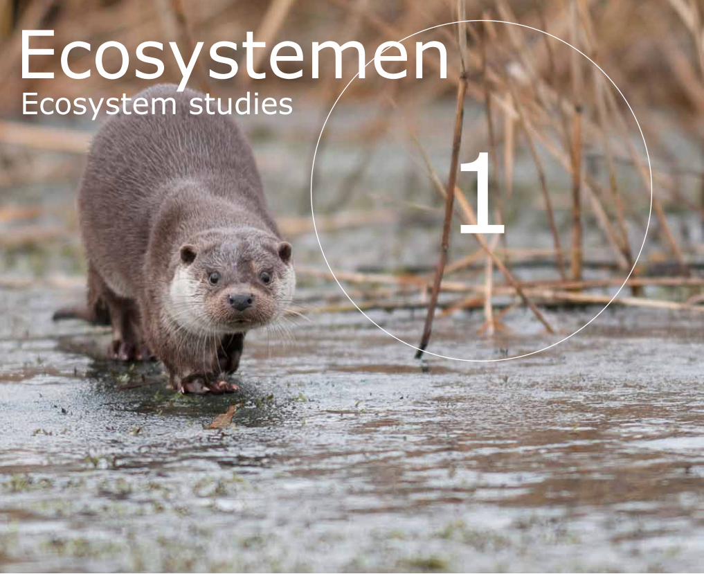
Zowel in Nederland als in de rest van Europa richt het natuur beleid zich sterk op het behoud en verhogen van de biodiver siteit. Hierbij worden drie verschillende niveaus onderscheiden, die onderling sterk samenhangen: diver siteit in ecosystemen, in soorten, en in genen. Een ecosysteem als geheel en de indi viduele soorten die daar deel van uit maken kunnen niet zonder elkaar voortbestaan. Maar soorten zijn daarnaast ook afhankelijk van voldoende genetische variatie. Diversiteit aan genetisch bepaalde eigenschappen bepaalt voor een groot deel de mogelijkheid van een soort en diens populaties om zich aan te passen aan een veranderende leefomgeving. Genetische verarming en inteelt vormen een bedreiging voor kleine populaties en kunnen leiden tot een verminderde overleving en reproductie.
Deze aandacht voor verschillende diversiteitsniveaus weer spiegelt zich in de actuele thema’ s in het natuurbeheer. Beheer en beleidsgericht ecologisch onderzoek richt zich onder meer op het belang van soortenrijkdom voor behoud van ecosysteemfuncties, en de duurzame instandhouding van populaties van kwetsbare en bedreigde soorten (o.a. door bepaling van de minimaal nood zakelijke populatiegrootte en mate van isolatie). Deels kan hiervoor gebruik worden gemaakt van conventionele methoden, zoals de bepaling van soortenrijkdom op basis van uiterlijke kenmerken, en gedetailleerde demografische studies.
In the Netherlands, as in the rest of Europe, nature policy is highly focused on preserving and increasing biodiversity. A distinction is made between three interdependent levels: diversity of ecosystems, species and genes. An ecosystem as a whole and the individual species it includes cannot survive independent of one another. Furthermore, species are dependent on sufficient genetic variation. Diversity of genetically determined characteristics largely dictates how a species and its populations can adapt to a changing environment. Genetic impoverishment and inbreeding represent a threat to small populations, and can lead to decreased survival and reproduction.
This attention to various levels of diversity is reflected in current themes in nature management. Management and policyoriented ecology research includes a focus on the importance of species richness for the conservation of ecosystem functions and the sustainable preservation of populations of fragile and threatened species (for example, by determining the minimum required population size and degree of isolation). This can be done, in part, using conventional methods, such as the determination of relative species abundance on the basis of external characteristics, and detailed demographic studies.
Biodiversiteit, natuurbeheer en nieuwe moleculaire technieken
Biodiversity, nature management and new molecular techniques
Contact Jack Faber, Arjen de Groot, Ivo Laros, Hugh Jansman
8
Steeds vaker zijn echter ook moleculaire technieken beschikbaar en voordelig in gebruik, omdat ze sneller antwoord geven op een vraag of minder verstoring veroorzaken aan de onderzochte dieren of planten. Daarnaast leveren moleculaire methoden ongekende nieuwe mogelijkheden. Nu het gebruik ervan in sneltreinvaart gemakkelijker en goedkoper wordt, o.a. door ontwikkelingen in forensisch misdaadonderzoek, zijn dergelijke technieken steeds beter toepasbaar in ecologisch onderzoek.
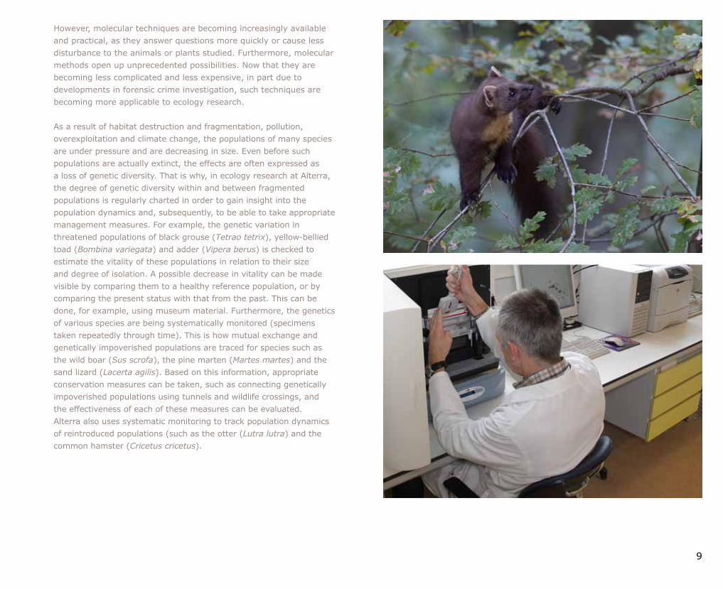
Als gevolg van de vernietiging en versnippering van leefgebied, vervuiling, overexploitatie en klimaatverandering staan de populaties van veel soorten onder druk, en nemen af in grootte. Nog voordat zulke populaties daadwerkelijk uitsterven, uiten de gevolgen zich vaak in de vorm van verlies van genetische diversiteit. In het ecologisch onderzoek van Alterra wordt daarom regelmatig ingezet op het in kaart brengen van de mate van genetische diversiteit binnen en tussen versnipperde populaties, om inzicht te krijgen in de populatiedynamiek en vervolgens de juiste beheersmaatregelen te kunnen nemen. Zo wordt de genetische variatie in bedreigde populaties van onder andere de korhoen (Tetrao tetrix), geelbuikvuurpad (Bombina variegata) en adder (Vipera berus), getoetst om een inschatting te maken van de levensvatbaarheid van deze populaties, in relatie tot hun omvang en mate van isolatie. Een eventuele af name in vitaliteit kan zichtbaar worden gemaakt door een vergelijking met een gezonde referentiepopulatie of door de status te vergelijken met die uit het verleden, bijvoorbeeld door gebruik te maken van museummateriaal. Daarnaast worden diverse soorten syste matisch genetisch gemonitord (herhaalde monstername door de tijd heen). Voor o.a. het wild zwijn (Sus scrofa), de boommarter (Martes martes) en de zandhagedis (Lacerta agilis) worden zo onderlinge uitwisseling en genetisch verarmde populaties opgespoord. Op basis daarvan kunnen de juiste beheersmaatregelen worden genomen, zoals het verbinden van genetisch verarmde populaties door tunnels en ecoducten, en kan tevens de effec tiviteit van deze maatregelen worden getoetst. Ook voor het volgen van de populatiedynamiek van geherintroduceerde populaties (zoals de otter (Lutra lutra) en de hamster (Cricetus cricetus) maakt Alterra gebruik van systematische monitoring.
JanuariDocent van het jaar
Gert Peek, docent Bodemkunde, is in januari 2011 verkozen tot Wagenings Docent van het Jaar. Aan de verkiezing namen 1200 studenten deel. Op basis van o.a vakken evaluaties en scores van afgelopen jaren was er een voorselectie gemaakt van 171 docenten, waaruit de studenten konden kiezen. Daaruit werden vijf docenten genomineerd, waarvan er vier van de ESG afkomstig waren. Behalve Gert Peek waren dat Jan Willem van Groenigen (Bodemvruchtbaarheid), Ute SassKlaassen (Bosecologie) en Paul Torfs (Hydrologie). Een jury van zeven studenten bepaalde de einduitslag. De prijs is bedoeld om kwalitatief hoog onderwijs aan de universiteit te stimuleren.
JanuaryTeacher of the Year
Gert Peek, soil sciences lecturer, was elected ‘Wageningen Teacher of the Year’ by 1200 students in January 2011. A preliminary selection of 171 teachers was made based on feedback including course evaluations and scores from previous years. Nominations followed for five of those teachers, four of whom were from the ESG: Gert Peek, Jan Willem van Groenigen (soil fertility), Ute SassKlaassen (forest ecology) and Paul Torfs (hydrology). A jury of seven students determined the final outcome. The title is awarded at the university to encourage highquality education.
9
However, molecular techniques are becoming increasingly available and practical, as they answer questions more quickly or cause less disturbance to the animals or plants studied. Furthermore, molecular methods open up unprecedented possibilities. Now that they are becoming less complicated and less expensive, in part due to developments in forensic crime investigation, such techniques are becoming more applicable to ecology research.
As a result of habitat destruction and fragmentation, pollution, overexploitation and climate change, the populations of many species are under pressure and are decreasing in size. Even before such populations are actually extinct, the effects are often expressed as a loss of genetic diversity. That is why, in ecology research at Alterra, the degree of genetic diversity within and between fragmented populations is regularly charted in order to gain insight into the population dynamics and, subsequently, to be able to take appropriate management measures. For example, the genetic variation in threatened populations of black grouse (Tetrao tetrix), yellowbellied toad (Bombina variegata) and adder (Vipera berus) is checked to estimate the vitality of these populations in relation to their size and degree of isolation. A possible decrease in vitality can be made visible by comparing them to a healthy reference population, or by comparing the present status with that from the past. This can be done, for example, using museum material. Furthermore, the genetics of various species are being systematically monitored (specimens taken repeatedly through time). This is how mutual exchange and genetically impoverished populations are traced for species such as the wild boar (Sus scrofa), the pine marten (Martes martes) and the sand lizard (Lacerta agilis). Based on this information, appropriate conservation measures can be taken, such as connecting genetically impoverished populations using tunnels and wildlife crossings, and the effectiveness of each of these measures can be evaluated. Alterra also uses systematic monitoring to track population dynamics of reintroduced populations (such as the otter (Lutra lutra) and the common hamster (Cricetus cricetus).
10
Het bepalen van de genetische verwantschap tussen populaties en individuen is voor Alterra een handig hulpmiddel voor het beantwoorden van ecologische beheer en beleidsvragen. Zo kan bijvoorbeeld de herkomst van nieuw gevestigde populaties worden bepaald (zoals van het wild zwijn) of kan een selectie worden gemaakt van geschikte donorpopulaties voor herintroductie (otter, hamster). Moderne genetische markers bieden ook de mogelijkheid om individuele dieren van elkaar te onderscheiden en hun ouders en grootouders te identificeren. Op basis van deze informatie worden, bijvoorbeeld voor bedreigde (korhoen) of geherintroduceerde populaties (otter) diverse dierecologische processen in beeld gebracht, zoals het voort plantingssucces en het aantal dieren dat bij voortplanting betrokken is. Genetische verwantschapsbepaling wordt daarnaast gebruikt voor forensisch onderzoek. Door ouderschaps bepaling van dieren in gevangenschap kan worden onderzocht of de opgegeven ouders de werkelijke ouders zijn, of dat mogelijk sprake is van illegale wildvang.
Waar mogelijk maakt Alterra gebruik van monstermethoden waarbij het vangen of verstoren van dieren niet nodig is. Zo wor den genetische profielen verkregen uit achtergelaten eischalen, veren, geweien, vervellingshuiden, haren of uitwerpselen.
The determination of genetic connectivity among populations and individuals helps Alterra answer ecology management and policy questions. For example, the origin of newly established populations can be determined in this way (e.g. for the wild boar), or a selection can be made from appropriate donor populations for reintroduction (otter, hamster). Modern genetic markers also make it possible to distinguish individual animals from one another and to identify their parents and grandparents. This information is used, for example for threatened (black grouse) or reintroduced populations (otter), to map various animal ecological processes such as the reproduction success and the number of animals involved in reproduction. Determination of genetic connectivity is also used for forensic research. Parental determination of animals in captivity can be used to investigate whether the declared parents are the actual parents, or perhaps there has been illegal trapping of wild animals.
Wherever possible, Alterra employs sampling methods in which the capture or disturbance of animals is unnecessary. Genetic profiles, for example, are obtained from abandoned egg shells, feathers, antlers, shed skin, hair or excrement.
FebruariGroeiseizoen maand langer
In februari 2011 bestond de Natuurkalender van initiatiefnemer Arnold van Vliet precies tien jaar. Uit de waar nemingen blijkt dat het vroege voorjaar nu gemiddeld 17 dagen eerder begint dan halverwege vorige eeuw, terwijl de winter juist negendagen later begint. Gedurende de afgelopen 10 jaar was het groeiseizoen bijna een maand langer dan 50 tot 70 jaar geleden. Uit de meer dan 120.000 waarnemingen die de Natuurkalender bevat blijkt dat het ritme van de meeste planten en dieren nauw samenhangt met de temperatuur. De gemiddelde jaar temperatuur ligt inmiddels 1,3 graad Celsius hoger dan halverwege de vorige eeuw.
FebruaryGrowth season a month longer
February 2011 was the tenyear mark for the Nature Calendar started by Arnold van Vliet. Observations reveal that early spring now begins an average of 17 days earlier than it did halfway through the last century, while the winter actually starts nine days later than it used to. The growth season in the past ten years was nearly a month longer than it was 50 to 70 years ago. The more than 120,000 observations included in the Nature Calendar show that the biorhythm of most plants and animals is closely tied to temperature. The average annual temperature is now 1.3 degrees Celsius higher than it was in the middle of the twentieth century.
11
12
13
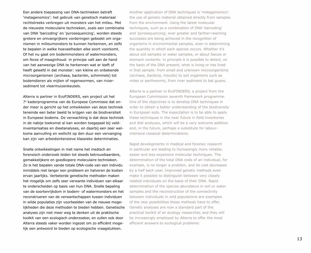
Een andere toepassing van DNAtechnieken betreft ‘meta genomics’: het gebruik van genetisch materiaal rechtstreeks verkregen uit monsters van het milieu. Met de nieuwste mole culaire technieken, zoals een combinatie van DNA ‘barcoding’ en ‘pyrosequencing’, worden steeds grotere en omvangrijkere vorderingen geboekt om organismen in milieumonsters te kunnen herkennen, en zelfs te bepalen in welke hoeveelheden elke soort voorkomt. Of het nu gaat om bodemmonsters of watermonsters, om feces of maaginhoud: in principe valt aan de hand van het aanwezige DNA te herkennen wat er leeft of heeft geleefd in dat monster: van kleine en onbekende microorganismen (archaea, bacteriën, schimmels) tot bodemdieren als mijten of regen wormen, van riviersediment tot vleermuizenkeutels.
Alterra is partner in EcoFINDERS, een project uit het 7e kaderprogramma van de Europese Commissie dat onder meer is gericht op het ontwikkelen van deze techniek teneinde een beter beeld te krijgen van de biodiversiteit in Europese bodems. De verwachting is dat deze techniek in de nabije toekomst al kan worden toegepast bij veldinventarisaties en dieetanalyses, en daarbij een zeer welkome aanvulling en wellicht op den duur een vervanging kan zijn van arbeidsintensieve klassieke determinaties.
Snelle ontwikkelingen in met name het medisch en forensisch onderzoek leiden tot steeds betrouwbaardere, gemakkelijkere en goedkopere moleculaire technieken. Zo is het bepalen vande totale DNAcode van een individu inmiddels niet langer een probleem en halveren de kosten ervan jaarlijks. Verbeterde genetische methoden maken het mogelijk om zelfs zeer ver wante individuen van elkaar te onderscheiden op basis van hun DNA. Snelle bepaling van de soortenrijkdom in bodem of watermonsters en het reconstrueren van de verwantschappen tussen individuen in wilde populaties zijn voorbeelden van de nieuwe mogelijkheden die deze methoden te bieden hebben. Genetische analyses zijn niet meer weg te denken uit de praktische toolkit van een ecologisch onderzoeker, en zullen ook door Alterra steeds vaker worden ingezet om zo efficiënt mogelijk een antwoord te bieden op ecologische vraagstukken.
Another application of DNA techniques is ‘metagenomics’: the use of genetic material obtained directly from samples from the environment. Using the latest molecular techniques, such as a combination of DNA ‘barcoding’ and ‘pyrosequencing’, ever greater and fartherreaching successes are being achieved in the recognition of organisms in environmental samples, even in determining the quantity in which each species occurs. Whether it’s about soil samples or water samples, or about faeces or stomach contents: in principle it is possible to detect, on the basis of the DNA present, what is living or has lived in that sample: from small and unknown microorganisms (archaea, bacteria, moulds) to soil organisms such as mites or earthworms, from river sediment to bat guano.
Alterra is a partner in EcoFINDERS, a project from the European Commission seventh framework programme. One of the objectives is to develop DNA techniques in order to obtain a better understanding of the biodiversity in European soils. The expectation is to be able to apply these techniques in the near future in field inventories and diet analyses, which will be a very welcome addition and, in the future, perhaps a substitute for labourintensive classical determinations.
Rapid developments in medical and forensic research in particular are leading to increasingly more reliable, easier and less expensive molecular techniques. The determination of the total DNA code of an individual, for example, is no longer a problem, and its cost decreases by a half each year. Improved genetic methods even make it possible to distinguish between very closely related individuals on the basis of their DNA. Rapid determination of the species abundance in soil or water samples and the reconstruction of the connectivity between individuals in wild populations are examples of the new possibilities these methods have to offer. Genetic analyses are now a standard part of the practical toolkit of an ecology researcher, and they will be increasingly employed by Alterra to offer the most efficient answers to ecological problems.
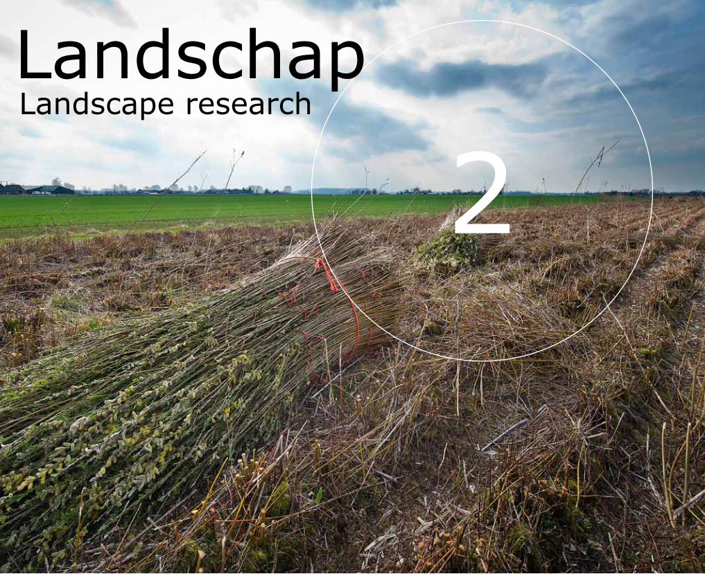
2LandschapLandscape research
15
In agrarische landschappen vormen natuurlijke patronen en processen een essentieel onderdeel van de landbouwsystemen. In toenemende mate krijgen deze landschappen te maken met geleidelijke of plotselinge veranderingen in de externe omgeving. Deze veranderingen kunnen liggen op het terrein van klimaat (droogte en overstromingen), gezondheid (epidemieën), grondstoffen (kunstmestprijzen), afzetmarkten (prijzen van zuivel en vlees) of economie (schaalvergroting). Het vermogen om met deze externe veranderingen om te gaan kan worden begrepen met behulp van het concept ‘veerkracht’.
Veerkracht kan gedefinieerd worden als het vermogen van een systeem om externe verstoringen op te vangen zonder verlies van bestaande functies of structuur. Deze definitie wordt veel gebruikt om veerkracht van eco systemen te analyseren. Een klassiek voorbeeld is hoeveel aanvoer van nutriënten een ecosysteem met helder water en planten kan doen omslaan in troebel water met algen. Er is dan sprake van een ‘shift’. Steeds meer wordt veerkracht ook toegepast op sociaalecologische systemen. Hierbij ligt de nadruk op perioden van langzame en snelle veranderingen en effecten daarvan op verschillende tijd en ruimteschalen. Ook begrippen als aanpassingsvermogen en omvormbaarheid spelen hierbij een grote rol.
In agrarian landscapes, natural patterns and processes form an essential part of the agricultural systems. These landscapes are being increasingly subjected to gradual or sudden changes in different spheres of the external environment, such as climate (drought and flooding), health (epidemics), raw materials (chemical fertiliser prices), markets (price of dairy and meat products) or the economy (increases in scale). The concept of ‘resilience’ can help us to understand the ability of landscapes to cope with these external changes. Resilience can be defined as the capacity of a system to respond to external disturbances without the loss of existing functions or structure. This definition is used widely in analysis of ecosystem resilience. A classic example is the amount of nutrient input required to transform an ecosystem with clear water and plants into one consisting of turbid water and algae. This transformation is called a ‘shift’. The concept of resilience is also increasingly being applied to socialecological systems. Here the emphasis is on periods of slow and rapid changes and the effects of these on different temporal and spatial scales. Concepts such as adaptability and transformability play an important role in this.
De veerkracht van agrarische landschappen
The resilience of agrarian landscapes
Contact Marthijn Sonneveld, Kasper Kok, Ilse Geijzendorffer, Edo Gies
16
Agrarische landschappen worden voor een belangrijk deel gebruikt en beheerd door agrariërs om de meeste bekende dienst te leveren, namelijk voedsel. Daarnaast worden veel andere diensten geleverd, zoals het zuiveren van lucht, het bewaren van cultureel en aardkundig erfgoed, vastlegging van koolstof en een kwalitatieve ruimte voor recreatie of wonen. Agrarische landschappen worden om dit scala aan diensten door vele verschillende actoren binnen onze maatschappij gewaardeerd en gebruikt. Een hoge mate van veerkracht in dit verband impliceert dus daarom niet alleen een instandhouding van het producerend vermogen maar ook een instandhouding of verbetering van andere functies.
Hoewel de Nederlandse agrarische landschappen van oudsher een belangrijke bijdrage leveren aan de economische successen van de nationale agrosector zien we concrete uitdagingen in het licht van toekomstige externe veranderingen. Veel regio’s kampen met krimpende aantallen boerenbedrijven wat zorgt voor spanning in het in stand houden van de leefbaarheid. Agrarische landschappen zijn, als zij niet veerkrachtig zijn, bijzonder vatbaar voor veranderingen. Voorbeelden zijn: te weinig flexibiliteit om de gevolgen van klimaatsverandering op te kunnen vangen, ziekten en plagen hebben meer vrij spel, maar ook het ontbreken van toekomstmogelijkheden voor boerenzonen en dochters brengt de voorzetting van agrarische activiteiten in Nederland in gevaar. De belangen voor een veerkrachtig agrarisch landschap zijn dus groot en liggen bij vrijwel alle actoren van de maatschappij.
In de voorbije decennia is vooral de productieintensivering beloond. Dit heeft geleid tot een hoge mate van afhankelijkheid van de toeleverende en afnemende sectoren (en daarmee een sterke gevoeligheid in prijswisselingen van bijvoorbeeld aardolie) en een vergaande rationalisering en homogenisering van het landschap met bijbehorend verlies van aardkundige waarden en biodiversiteit. Een sterke verandering in negatieve richting kan regionaal grote economische en sociale consequenties hebben.
Agrarian landscapes are largely used and managed by farmers in the delivery of the most obvious service ‒ that of food. But these landscapes provide many other services too, such as air purification, the maintenance of cultural and geological heritage, carbon storage and qualitative space for recreation and living. Agrarian landscapes are valued and used by many different actors within society for this range of services that they provide. In this context, a high degree of resilience implies therefore not only the maintenance of productive capacity but also the maintenance or improvement of other functions.
Although Dutch agrarian landscapes have traditionally made an important contribution to the economic success of the national agricultural sector, we now see particular challenges arising in the light of future external changes. Many regions are faced with declining numbers of farms and as a result maintaining liveability is becoming increasingly difficult. If they are not resilient, agrarian landscapes are likely to succumb to adverse changes. For example they may have too little flexibility to respond to climate change, or disease and pests may gain the upper hand. Moreover, the lack of future prospects for farmers’ offspring is endangering the continuation of farming in the Netherlands. A resilient agrarian landscape is of vital importance to almost all sectors of society. The stakes are therefore high.
In recent decades intensification of production has led to economic gains. However, this has resulted in a high degree of dependence of both the supply and market sectors (and with it a heightened sensitivity to price fluctuations such as those of oil) and extensive rationalisation and homogenisation of the landscape with concomitant losses of geological values and biodiversity. A strong change in a negative direction can have large regional economic and social consequences.
17
MaartActualisatie kaart Japan
Zo'n veertig studenten en medewerkers hebben in maart 2011 bij wijze van humanitaire actie gewerkt aan het actualiseren van de kaart van Japan na de verwoestende tsunami. Bestaande kaarten waren na de ramp niet bruikbaar meer. Wegen waren onbegaanbaar geworden, gebouwen stonden er niet meer. Hulpverleners kunnen zich dan niet meer oriënteren. Via Open Street Map en speciale software brachten Lieke Verhelst en collega’s bestaande kaarten met behulp van satellietfoto’s in overeenstemming met de nieuwe situatie. De actie vond plaats na werktijd, om aan te geven dat het om een donatie ging van onze kennis aan de hulpverlening in Japan.
MarchUpdating the map of Japan
As a humanitarian gesture following the destruction caused by the tsunami, approximately forty students and staff worked in March 2011 on an update of the map of Japan. Existing maps were no longer usable after the disaster: roads had become inaccessible, buildings had disappeared, and aid workers couldn’t get their bearings. Using Open Street Map and special software, and with the aid of satellite photos, Lieke Verhelst and colleagues brought existing maps into agreement with the new situation. The mapping took place after work hours to indicate that we were donating our expertise to help aid workers Japan.
Er zijn nu kansen om aan de veerkracht van het landschap te werken door diversifiëring, door het ondersteunen van duurzame productie met agroecologische systemen en door de toenemende maatschappelijke betrokkenheid bij een duurzame invulling van het landschap. Dat het Europese Gemeenschappelijk Landbouw Beleid (GLB) ook meer ingevuld wordt richting het gehele pallet aan diensten die landbouw voor de maatschappij kan leveren ondersteunt deze insteek.
Een van de belangrijkste maatschappelijke discussies ten aanzien van de agrarische systemen in Nederland gaat over de grootschalige ontwikkelingen in de veehouderij: het debat over megastallen. Voor en tegenstanders van megastallen zijn het er over eens dat een veehouderijbedrijf moet passen in zijn omgeving, niet alleen economisch, maar ook landschappelijk, ruimtelijk en sociaalcultureel. De grootte van een bedrijf op zich is ondergeschikt in de discussie. Ruimtelijke ordening is momenteel het belangrijkste instrument van provincies en gemeenten en deze stuurt met name op omvang. Uit onderzoek blijkt dat dit instrument echter tekort schiet om invulling te kunnen geven aan de nietruimtelijke aspecten van de maatschappelijke discussies over bijvoorbeeld dierenwelzijn, diergezondheid en volksgezondheid. Voor een veerkrachtige veehouderij zullen agrarische ondernemers het gesprek met hun omgeving moeten aangaan. Omgevingsgericht produceren door ondernemers (transparant, duurzaam, sociaal ingebed) lijkt daarmee ‘nieuwe ondernemerschapskwaliteiten’ te vereisen.
There are now opportunities to improve the resilience of the landscape through diversification, agroecological systems that support sustainable production and through the increasing social commitment to sustainable landscape implementation. This approach is also underpinned by the European Common Agricultural Policy (CAP), which is starting to shift towards a range of services that agriculture can supply to society.
One of the most important public debates concerning agrarian systems in the Netherlands centres around developments in the scale of livestock farming: the debate on ‘megastalls’. Supporters and opponents of these largescale livestock accommodation facilities agree that a livestock farm needs to fit in with its surroundings, not only in economic terms, but also in terms of landscape, and the spatial and sociocultural environment. The farm size itself is not the main focus of the debate. Regional planning is at present the most important instrument that provincial and municipal authorities have at their disposal, and this is based on size. Research has shown, however, that this instrument fails through its inability to take into account the nonspatial aspects of public debates on, for example, animal welfare, animal health and public health. For livestock farming to become resilient, farmers will have to engage in dialogue with others in their immediate surroundings. Environmentoriented production by entrepreneurs (transparent, sustainable and socially embedded) seems to require ‘new qualities of entrepreneurship’.
18
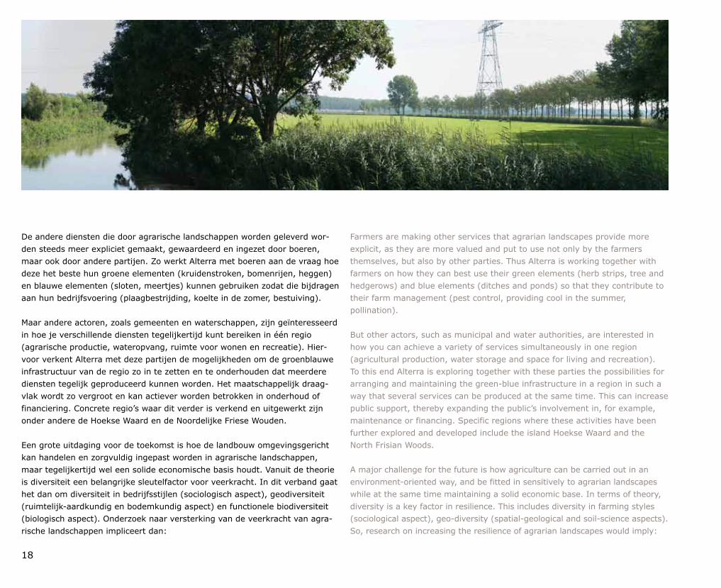
De andere diensten die door agrarische landschappen worden geleverd worden steeds meer expliciet gemaakt, gewaardeerd en ingezet door boeren, maar ook door andere partijen. Zo werkt Alterra met boeren aan de vraag hoe deze het beste hun groene elementen (kruidenstroken, bomenrijen, heggen) en blauwe elementen (sloten, meertjes) kunnen gebruiken zodat die bijdragen aan hun bedrijfsvoering (plaagbestrijding, koelte in de zomer, bestuiving).
Maar andere actoren, zoals gemeenten en waterschappen, zijn geïnteresseerd in hoe je verschillende diensten tegelijkertijd kunt bereiken in één regio (agrarische productie, wateropvang, ruimte voor wonen en recreatie). Hiervoor verkent Alterra met deze partijen de mogelijkheden om de groenblauwe infrastructuur van de regio zo in te zetten en te onderhouden dat meerdere diensten tegelijk geproduceerd kunnen worden. Het maatschappelijk draagvlak wordt zo vergroot en kan actiever worden betrokken in onderhoud of financiering. Concrete regio’s waar dit verder is verkend en uitgewerkt zijn onder andere de Hoekse Waard en de Noordelijke Friese Wouden.
Een grote uitdaging voor de toekomst is hoe de landbouw omgevingsgericht kan handelen en zorgvuldig ingepast worden in agrarische landschappen, maar tegelijkertijd wel een solide economische basis houdt. Vanuit de theorie is diversiteit een belangrijke sleutelfactor voor veerkracht. In dit verband gaat het dan om diversiteit in bedrijfsstijlen (sociologisch aspect), geodiversiteit (ruimtelijkaardkundig en bodemkundig aspect) en functionele biodiversiteit (biologisch aspect). Onderzoek naar versterking van de veerkracht van agrarische landschappen impliceert dan:
Farmers are making other services that agrarian landscapes provide more explicit, as they are more valued and put to use not only by the farmers themselves, but also by other parties. Thus Alterra is working together with farmers on how they can best use their green elements (herb strips, tree and hedgerows) and blue elements (ditches and ponds) so that they contribute to their farm management (pest control, providing cool in the summer, pollination).
But other actors, such as municipal and water authorities, are interested in how you can achieve a variety of services simultaneously in one region (agricultural production, water storage and space for living and recreation). To this end Alterra is exploring together with these parties the possibilities for arranging and maintaining the greenblue infrastructure in a region in such a way that several services can be produced at the same time. This can increase public support, thereby expanding the public’s involvement in, for example, maintenance or financing. Specific regions where these activities have been further explored and developed include the island Hoekse Waard and the North Frisian Woods.
A major challenge for the future is how agriculture can be carried out in an environmentoriented way, and be fitted in sensitively to agrarian landscapes while at the same time maintaining a solid economic base. In terms of theory, diversity is a key factor in resilience. This includes diversity in farming styles (sociological aspect), geodiversity (spatialgeological and soilscience aspects). So, research on increasing the resilience of agrarian landscapes would imply:
19
AprilEconomische schade stikstof
In Edinburgh is in april 2011 het eerste grootschalige Europese onderzoek naar de stikstofproblematiek gepresenteerd. Stikstof is nodig om een groeiende wereldbevolking te voeden, maar vervuilt lucht, bodem en water. Het onderzoek wees uit dat stikstofvervuiling de Europese burger jaarlijks 150 tot 740 euro kost, in totaal naar schatting 70 tot 320 miljard euro. Dat is ruim twee keer zo veel als de extra winst die in de Europese landbouw wordt gemaakt door stikstofhoudende mest stoffen te gebruiken. Het onderzoek werd uitgevoerd door 200 experts uit 21 landen en 89 organisaties, waaronder vanuit de ESG Wim de Vries, Oene Oenema en Hans Kros.
AprilFinancial damage from nitrogen
In Edinburgh in April 2011, the first largescale European study on nitrogen issues was presented. Nitrogen is necessary to feed the growing world population, yet it pollutes the air, soil and water. The study showed that nitrogen pollution costs the European citizen 150 to 740 euros, adding up to an estimated 70 to 320 billion euros. That is more than twice as much as the extra profit earned in European agriculture by using nitrogencontaining fertilisers. The study was carried out by 200 experts from 21 countries and 89 organisations. Wim de Vries, Oene Oenema and Hans Kros represented the ESG.
• Een accent op de vervlechting tussen de natuurlijke factoren (bodem, hydrologie, biodiversiteit) en het management van de boer. Er kan optimaler gebruik worden gemaakt van het agroecosysteem in de brede zin van diensten en verbreding binnen het bedrijfssysteem met aandacht voor kringlopen.
• Een bewustere benutting van het agrarische landschap voor alle diensten die zij levert en daarvoor samenwerking met meerdere actoren. Dit vraagt een regiospecifieke aanpak (diversifiëring) en inzicht in de snelle en langzame ‘drivers’ van veranderingen.
• De sturing in de regio moet ruimte bieden om deze diversifiëring tussen bedrijfssystemen in een regio mogelijk te maken en zelfs te stimuleren.
De grootste wetenschappelijke uitdaging zit in het concretiseren van het bredere veerkrachtperspectief in de vorm van modellen en andere methoden die handen en voeten kunnen geven aan dit algemene concept. Hierbij is vooral de samenhang tussen inventarisaties, (ecologische) modellen en meer sociale methoden van belang. Essentieel is dat dit onderzoek in nauwe samenhang plaatsvindt met verschillende actoren die belangen hebben in deze landschappen.
• Emphasis on how the natural factors (soil, hydrology, biodiversity) and the farmer’s management are intertwined. Use of the agroecosystem can be optimised in terms of services offered and by extending the farming system so that cycles are incorporated.
• A more conscious use of the agrarian landscape for all services it supplies and cooperation with several actors for this to take place. This requires a regionspecific approach (diversification) and understanding of the fast and slow ‘drivers’ of change.
• Regional authorities must offer space so that diversification between farming systems in a region is possible and should even stimulate this.
The greatest scientific challenge is to convert the broader perspective on resilience into tangible models and other methods that can help shape this rather general concept. This requires above all cohesion between inventories, (ecological) models and more social methods. It is essential that this research be carried out in close cooperation with the various actors that have a stake in these landscapes.
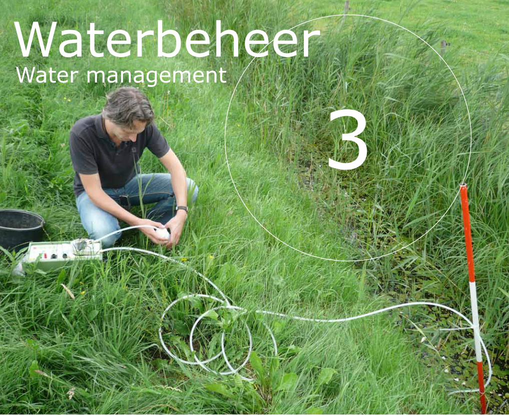
3WaterbeheerWater management
21
Binnen het project Monitoring Stroomgebieden is onderzocht wat de bronnen zijn van de nutriënten in het oppervlaktewater, via welke routes de nutriënten in het water terecht komen en op welke wijze gestuurd kan worden op schoon water.
Het onderzoek concentreerde zich in vier duidelijk van elkaar onderscheiden stroomgebieden. In de veenweidepolder Krimpenerwaard was de invloed van de veenbodem kenmerkend. In de kleipolder Quarles van Ufford speelde het inlaat water een bepalende rol. De twee onderzochte beeksystemen in zandgebieden (Schuitenbeek en Drentse Aa) waren gekozen vanwege de verwachte verschillen in nutriëntenbelasting – de Schuitenbeek hoog en de Drentse Aa laag.
De kwaliteit van het oppervlaktewater is verbeterd in de afge lopen decennia. In alle vier de onderzochte stroomgebieden zijn de concentraties van stikstof in het oppervlaktewater signi ficant afgenomen. Voor fosfor zijn de concentraties in het oppervlaktewater over de gehele meetreeks alleen in de gebieden Drentse Aa en Quarles van Ufford significant dalend. De in de zomer geldende normen vanuit de Kaderrichtlijn Water worden dan ook nog niet overal gehaald. In de Schuitenbeek en de Krimpenerwaard zijn de fosforconcentraties hoger dan de norm die de waterschappen hanteren vanuit de Kaderrichtlijn Water.
The Monitoring Stroomgebieden (Monitoring Catchment Areas) project studied the origins of the nutrients found in surface water, the routes via which the nutrients enter surface water and ways of making the water cleaner.
The research focused on four distinct catchment areas. In the Krimpenerwaard, a peatland polder, the influence of the peat soil was clearly visible. In the Quarles van Ufford polder, where the soil is clayey, the intake water played an important role. The two stream systems in sandy areas that were studied (Schuitenbeek and Drentse Aa) were chosen because of the expected differences in nutrient load – high in the Schuitenbeek and low in the Drentse Aa.
The surfacewater quality has improved over recent decades. In all four catchment areas the surfacewater concentrations of nitrogen have gone down significantly. However, for the entire series of measurements, significant decreases in the surfacewater concentrations of phosphorus were found only in the Drentse Aa and Quarles van Ufford. The summer standards set by the Water Framework Directive have not been achieved everywhere. The phosphorus concentrations in the Schuitenbeek and the Krimpenerwaard are higher than the Water Framework Directive standard that the water boards adhere to.
Sturen op schoon water
Steering towards clean water
Contact Dorothée van TolLeenders
Publicatie | PublicationMartin Woestenburg en Dorothée van TolLeendersSturen op schoon water; eindrapportage project Monitoring Stroomgebieden. 2011. Alterra/Deltares
22
In alle gebieden zijn de stikstofconcentraties in de winterperiode hoger dan in de zomer, omdat het neerslagoverschot dan zorgt voor een grotere uitspoeling. Voor de Drentse Aa en Quarles van Ufford geldt dit ook voor fosfor. De grote vraag in het project was of de veranderingen in de kwaliteit van het oppervlaktewater een resultaat zijn van het mestbeleid. Uit modelberekeningen blijkt dat het mestbeleid invloed heeft gehad op de kwaliteit van het oppervlaktewater. De stikstofconcentraties in het oppervlaktewater zijn in alle gebieden duidelijk lager door het mestbeleid. Vooral in het sterk door de landbouw beïnvloede stroomgebied van de Schuitenbeek is het effect goed zichtbaar. Voor fosfor heeft het mestbeleid ook gewerkt. De fosforpieken in de zomer in de Schuitenbeek zijn bijvoorbeeld verminderd. In Quarles van Ufford is het effect van het mestbeleid op de kwaliteit van het oppervlaktewater in de zomermaanden echter gering.
The nitrogen concentrations in all areas are higher during the winter than in the summer. This is because the precipitation excess causes more leaching. The phosphorus concentrations are also higher in the winter than in the summer in the Drentse Aa and Quarles van Ufford. The main question that the project addressed was whether the changes in quality of the surface water were the result of the Dutch manure policy. Model calculations have shown that this policy has indeed had an effect on the quality of surface water. The surface water nitrogen concentrations are noticeably lower in all areas. The effect is particularly visible in the Schuitenbeek catchment area, an area strongly affected by agriculture. The fertiliser policy has also had a positive effect on phosphorus levels. For example, the summer phosphorus peaks in the Schuitenbeek have declined. In the Quarles van Ufford polder, however, the effect of the fertiliser policy on the quality of surface water during the summer months has been low.
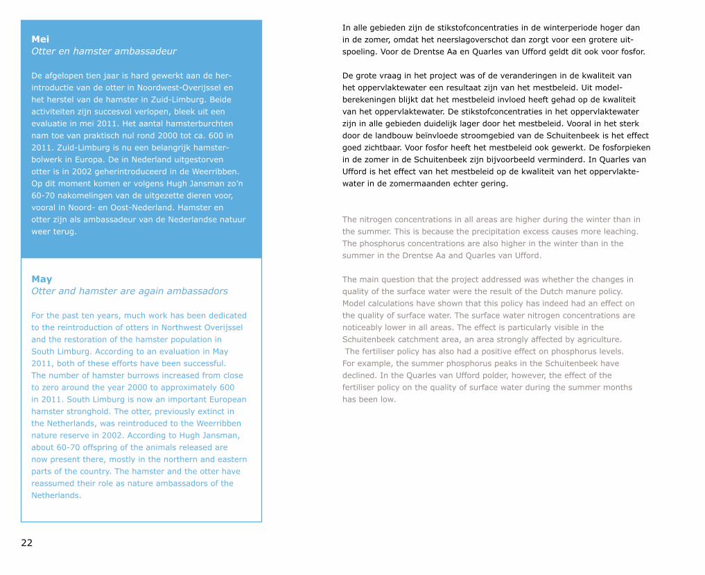
MeiOtter en hamster ambassadeur
De afgelopen tien jaar is hard gewerkt aan de her intro ductie van de otter in NoordwestOverijssel en het herstel van de hamster in ZuidLimburg. Beide activiteiten zijn succesvol verlopen, bleek uit een evaluatie in mei 2011. Het aantal hamster burchten nam toe van praktisch nul rond 2000 tot ca. 600 in 2011. ZuidLimburg is nu een belangrijk hamsterbolwerk in Europa. De in Nederland uit gestorven otter is in 2002 geherintroduceerd in de Weerribben. Op dit moment komen er volgens Hugh Jansman zo’n 6070 nakomelingen van de uitgezette dieren voor, vooral in Noord en OostNederland. Hamster en otter zijn als ambassadeur van de Nederlandse natuur weer terug.
MayOtter and hamster are again ambassadors
For the past ten years, much work has been dedicated to the reintroduction of otters in Northwest Overijssel and the restoration of the hamster population in South Limburg. According to an evaluation in May 2011, both of these efforts have been successful. The number of hamster burrows increased from close to zero around the year 2000 to approximately 600 in 2011. South Limburg is now an important European hamster stronghold. The otter, previously extinct in the Netherlands, was reintroduced to the Weerribben nature reserve in 2002. According to Hugh Jansman, about 6070 offspring of the animals released are now present there, mostly in the northern and eastern parts of the country. The hamster and the otter have reassumed their role as nature ambassadors of the Netherlands.
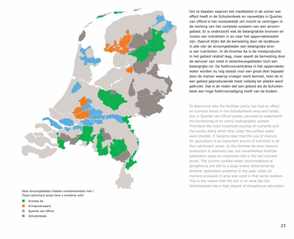
Overeenkomsten met:Drentse Aa
Krimpenerwaard
Quarles van Ufford
Schuitenbeek
23
Deze stroomgebieden hebben overeenkomsten met | These catchment areas have a similarity with:
Drentse Aa
Krimpenerwaard
Quarles van Ufford
Schuitenbeek
Om te bepalen waarom het mestbeleid in de zomer wel effect heeft in de Schuitenbeek en nauwelijks in Quarles van Ufford is het noodzakelijk om inzicht te verkrijgen in de werking van het complete systeem van een stroomgebied. Er is onderzocht wat de belangrijkste bronnen en routes van nutriënten in en naar het oppervlaktewater zijn. Daaruit blijkt dat de bemesting door de landbouw in alle vier de stroomgebieden een belangrijke bron is van nutriënten. In de Drentse Aa is de mestproductie in het gebied relatief laag, maar speelt de bemesting door de aanvoer van mest in akkerbouwgebieden toch een belangrijke rol. De fosforconcentraties in het oppervlaktewater worden nu nog steeds voor een groot deel bepaald door de manier waarop vroeger werd bemest, toen de in een gebied geproduceerde mest volledig ter plekke werd gebruikt. Dat is de reden dat een gebied als de Schuitenbeek een hoge fosforverzadiging heeft van de bodem.
To determine why the fertiliser policy has had an effect on summer levels in the Schuitenbeek area and hardly any in Quarles van Ufford polder, we need to understand the functioning of an entire hydrographic system. Therefore the most important sources of nutrients and the routes along which they enter the surface water were studied. It became clear that the use of manure for agriculture is an important source of nutrients in all four catchment areas. In the Drentse Aa area manure production is relatively low, but nevertheless fertilizer application plays an important role in the soil nutrient levels. The current surfacewater concentrations of phosphorus are still to a large extent determined by fertiliser application practices in the past, when all manure produced in area was used in that same location. This is the reason that the soil in an area like the Schuitenbeek has a high degree of phosphorus saturation.
24
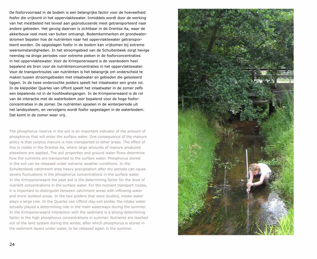
De fosforvoorraad in de bodem is een belangrijke factor voor de hoeveelheid fosfor die vrijkomt in het oppervlaktewater. Inmiddels wordt door de werking van het mestbeleid het teveel aan geproduceerde mest getransporteerd naar andere gebieden. Het gevolg daarvan is zichtbaar in de Drentse Aa, waar de akkerbouw veel mest van buiten ontvangt. Bodemkenmerken en grondwaterstromen bepalen hoe de nutriënten naar het oppervlaktewater getransporteerd worden. De opgeslagen fosfor in de bodem kan vrijkomen bij extreme weersomstandigheden. In het stroomgebied van de Schuitenbeek zorgt hevige neerslag na droge periodes voor extreme pieken in de fosforconcentraties in het oppervlaktewater. Voor de Krimpenerwaard is de veenbodem heel bepalend als bron voor de nutriëntenconcentraties in het oppervlaktewater. Voor de transportroutes van nutriënten is het belangrijk om onderscheid te maken tussen stroomgebieden met inlaatwater en gebieden die geïsoleerd liggen. In de twee onderzochte polders speelt het inlaatwater een grote rol. In de kleipolder Quarles van Ufford speelt het inlaatwater in de zomer zelfs een bepalende rol in de hoofdwatergangen. In de Krimpenerwaard is de rol van de interactie met de waterbodem zeer bepalend voor de hoge fosforconcentraties in de zomer. De nutriënten spoelen in de winterperiode uit het landsysteem, en vervolgens wordt fosfor opgeslagen in de waterbodem. Dat komt in de zomer weer vrij.
The phosphorus reserve in the soil is an important indicator of the amount of phosphorus that will enter the surface water. One consequence of the manure policy is that surplus manure is now transported to other areas. The effect of this is visible in the Drentse Aa, where large amounts of manure produced elsewhere are applied. The soil properties and ground water flows determine how the nutrients are transported to the surface water. Phosphorus stored in the soil can be released under extreme weather conditions. In the Schuitenbeek catchment area heavy precipitation after dry periods can cause severe fluctuations in the phosphorus concentrations in the surface water. In the Krimpenerwaard the peat soil is the determining factor for the level of nutrient concentrations in the surface water. For the nutrient transport routes, it is important to distinguish between catchment areas with inflowing water and more isolated areas. In the two polders that were studied, intake water plays a large role. In the Quarles van Ufford claysoil polder, the intake water actually played a determining role in the main waterways during the summer. In the Krimpenerwaard interaction with the sediment is a strong determining factor in the high phosphorus concentrations in summer. Nutrients are leached out of the land system during the winter, after which phosphorus is stored in the sediment layers under water, to be released again in the summer.
25
JuniNederlanders houden van bossen
Bossen zijn het meest favoriete landschap van de Nederlanders. De web site www.daarmoetikzijn.nl van Martin Goossen bestond in juni 2011 vijf jaar. Bijna 35.000 mensen hebben in die periode op deze site hun voorkeuren voor bepaalde landschappen kenbaar gemaakt. De gemiddelde Nederlander wil het liefst 30% bos hebben in zijn of haar ideale landschap. Daarnaast moet het ook circa 20% water bevatten. Het rapportcijfer voor de gemiddelde aantrekkelijkheid van het landschap rond de eigen woonplaats is 6,9 (op een schaal van 1 tot 10). Naarmate de bezoeker van de website ouder is, vindt deze het landschap rond de eigen woonplaats aantrekkelijker.
JuneThe Dutch like their forests
Forests are the favourite landscape of citizens of the Netherlands. Martin Goossen’s website www.myplacetobe.eu celebrated its fifth anniversary in June 2011. In those five years, nearly 35,000 people declared their preferences for specific landscapes. The average Dutch person wanted his or her landscape to include 30% forest and about 20% water. People awarded an average score of 6.9 (on a scale from 1 to 10) for the attractiveness of the landscape near their homes – and the older the website visitor, the higher the marks.
Na het in kaart brengen van de belangrijkste bronnen en transportroutes is in Monitoring Stroomgebieden voor de gebieden onderzocht hoe kan worden gestuurd op de nutriënten in het oppervlaktewater. De landbouw is in alle gebieden een belangrijke bron voor de nutriënten in het oppervlaktewater. Een deel wordt verklaard door de actuele mestgiften en een groter deel door de oplading van de bodem mede als gevolg van de mestgiften in het verleden. Generiek mestbeleid, het verminderen van de milieubelasting door de bemesting, heeft daardoor een beperkte invloed op de kwaliteit van het oppervlaktewater in de stroomgebieden. Minder of efficiënter bemesten zorgt in alle stroomgebieden voor een relatief snelle vermindering van de stikstofbelasting, maar voor een geringe vermindering van de fosforconcentraties in het oppervlaktewater in stroom gebieden, als gevolg van de fosfaatoplading van de bodem. Een effectieve aanpak van de kwaliteit van het oppervlaktewater betekent een combinatie van gerichte maat regelen en maatwerk. De sturingsmogelijkheden voor de stroomgebieden van de Krimpenerwaard, de Drentse Aa, de Schuitenbeek en Quarles van Ufford zijn erg verschillend. In de Krimpenerwaard kan worden gestuurd op minder en efficiënter bemesten, en is er veel aandacht nodig voor de processen in de waterbodem en de rol van sulfaat in het veen en de waterbodem. In de Drentse Aa is een gerichte sturing in de landbouwgebieden mogelijk om de waterkwaliteit te verbeteren, bijvoorbeeld door andere teelten te stimuleren. Bij de Schuitenbeek moet rekening gehouden worden met de fosfor voorraad in de bodem. In Quarles van Ufford is de rol van het inlaatwater groot. Het effect van deze brongerichte sturingsmogelijkheden kan worden versterkt door het gebied optimaler in te richten, zoals het laten hermeanderen van beken en de aanleg van natuurvriendelijke oevers. Overal blijkt winst mogelijk, mits er gericht gestuurd wordt.
After inventorying the main sources and transport routes for nutrients, the Monitoring Stroomgebieden project went on to examine how nutrient levels in the surface water can be managed. In all areas agriculture is an important source of surfacewater nutrients. This is partly due to current fertiliser application and to a larger extent due to the accumulation in the soil as the result of manuring activities in the past. A general manure policy, aimed at reducing environmental pollution from fertiliser, therefore only has a limited influence on surfacewater quality in the catchment areas. Reduced or more efficient fertiliser application leads to a relatively rapid decline in nitrogen loads in all areas, but relatively small reductions in surfacewater phosphorus concentrations because of the phosphorus accumulation in the soil. An effective approach to improving the quality of surface water requires a combination of specific and tailormade measures. The possibilities for steering these processes in the four different catchment areas vary considerably. In the Krimpenerwaard reduced and more efficient fertiliser application is appropriate, and careful attention must be paid to sediment processes and the role of sulphates in the peat and sediment. In the Drentse Aa water quality can be improved through directed interventions in agricultural areas, for example by encouraging the cultivation of different crops. In the Schuitenbeek area the level of the phosphorus reserves in the soil must be taken into account. In the Quarles van Ufford polder the intake water plays a major role. The effect of sourceoriented control measures can be reinforced by ensuring that an area as a whole is optimally designed, for example by letting streams meander as they used to and by making their banks nature friendly. Gains are possible everywhere, as long as interventions are clearly directed.
4BodemSoil science
27
Klimaatverandering. Voedselzekerheid. Wereldwijde Watervoorziening. Biodiversiteit. Wetenschappers uit allerlei disciplines dragen in multidisciplinaire denktanks intensief bij aan het bedenken van oplossingen voor deze vraagstukken, maar bodemkundigen hebben in deze denktanks en discussies een opmerkelijk bescheiden profiel. Dit is des te opmerkelijker als je de cruciale rol van de bodem in ogenschouw neemt.
Om slechts een paar voorbeelden te noemen. De bodem is één van de grootste koolstofreservoirs op aarde; erg belangrijk dus voor klimaatontwikkeling. De bodem is vanzelfsprekend één van de belangrijkste voorwaarden voor de wereldvoedselproductie. De bodem functioneert als reservoir voor de berging van water, wat onder andere gunstig is tegen overstromingen, en als filter voor de reiniging van water, wat onder andere zorgt voor goed drinkwater. De bodem bevat een ongekende biodiversiteit waarvan we nog slechts een fractie hebben ontdekt, en die een grote invloed uitoefent op de bovengrondse biodiversiteit waar we ons vaak meer zorgen over maken.
Climate change. Food security. Global water supply. Biodiversity. While scientists from many disciplines contribute intensively to the search for solutions to these issues in multidisciplinary thinktanks, soil scientists have kept a remarkably low profile in such thinktanks and discussions . This is even more remarkable if we consider the central importance of soils to all of these issues.
A couple of examples: the soil represents one of the largest carbon reservoirs on earth, and is therefore extremely important for climate development. It goes without saying that soil quality is one of the most important factors for world food production. The soil also functions as a reservoir for storing water, with the additional advantage that it offers protection against flooding. Soil filters water too, thus purifying it and providing us with safe drinking water. Moreover, the world’s soil contains tremendous biodiversity, of which we have discovered only a fraction. This underground diversity has an enormous influence on the aboveground biodiversity, which we often worry about more.
Wageningen Soil Meeting zet bodemkunde op de kaart
Wageningen Soil Meeting puts soil science on the map
Contact Gerben Mol, Saskia Keesstra
28
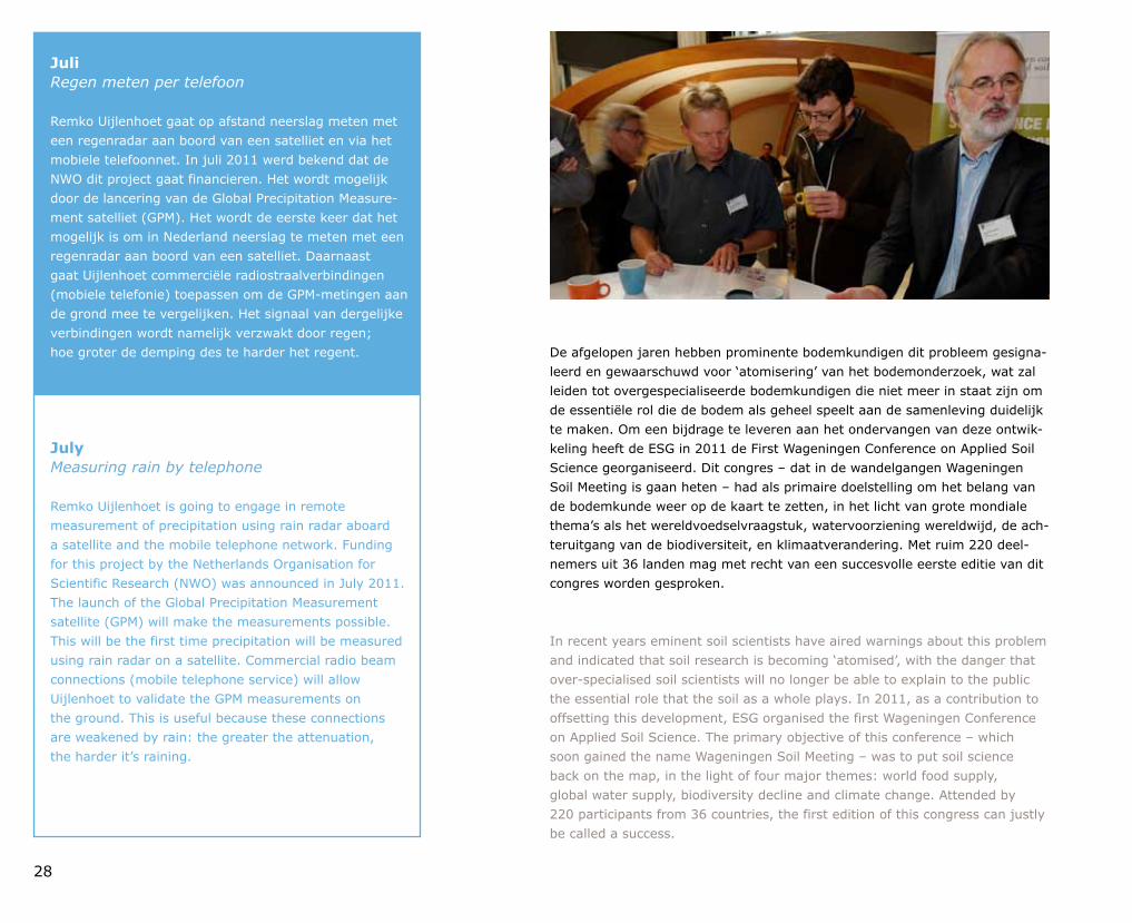
De afgelopen jaren hebben prominente bodemkundigen dit probleem gesignaleerd en gewaarschuwd voor ‘atomisering’ van het bodemonderzoek, wat zal leiden tot over gespecialiseerde bodemkundigen die niet meer in staat zijn om de essentiële rol die de bodem als geheel speelt aan de samenleving duidelijk te maken. Om een bijdrage te leveren aan het ondervangen van deze ontwikkeling heeft de ESG in 2011 de First Wageningen Conference on Applied Soil Science georganiseerd. Dit congres – dat in de wandelgangen Wageningen Soil Meeting is gaan heten – had als primaire doelstelling om het belang van de bodemkunde weer op de kaart te zetten, in het licht van grote mondiale thema’s als het wereldvoedselvraagstuk, watervoorziening wereldwijd, de achteruitgang van de biodiversiteit, en klimaatverandering. Met ruim 220 deelnemers uit 36 landen mag met recht van een succesvolle eerste editie van dit congres worden gesproken.
In recent years eminent soil scientists have aired warnings about this problem and indicated that soil research is becoming ‘atomised’, with the danger that overspecialised soil scientists will no longer be able to explain to the public the essential role that the soil as a whole plays. In 2011, as a contribution to offsetting this development, ESG organised the first Wageningen Conference on Applied Soil Science. The primary objective of this conference – which soon gained the name Wageningen Soil Meeting – was to put soil science back on the map, in the light of four major themes: world food supply, global water supply, biodiversity decline and climate change. Attended by 220 participants from 36 countries, the first edition of this congress can justly be called a success.
JuliRegen meten per telefoon
Remko Uijlenhoet gaat op afstand neerslag meten met een regenradar aan boord van een satelliet en via het mobiele telefoonnet. In juli 2011 werd bekend dat de NWO dit project gaat financieren. Het wordt mogelijk door de lancering van de Global Precipitation Measurement satelliet (GPM). Het wordt de eerste keer dat het mogelijk is om in Nederland neerslag te meten met een regenradar aan boord van een satelliet. Daarnaast gaat Uijlenhoet commerciële radiostraalverbindingen (mobiele telefonie) toepassen om de GPMmetingen aan de grond mee te vergelijken. Het signaal van dergelijke verbindingen wordt namelijk verzwakt door regen; hoe groter de demping des te harder het regent.
JulyMeasuring rain by telephone
Remko Uijlenhoet is going to engage in remote measurement of precipitation using rain radar aboard a satellite and the mobile telephone network. Funding for this project by the Netherlands Organisation for Scientific Research (NWO) was announced in July 2011. The launch of the Global Precipitation Measurement satellite (GPM) will make the measurements possible. This will be the first time precipitation will be measured using rain radar on a satellite. Commercial radio beam connections (mobile telephone service) will allow Uijlenhoet to validate the GPM measurements on the ground. This is useful because these connections are weakened by rain: the greater the attenuation, the harder it’s raining.
29
Een belangrijke manier om ‘atomisering’ te vermijden was de thematische organisatie van het congres. Er was bewust niet gekozen voor traditionele parallelle sessies waar bijvoorbeeld bodemfysici, bodemchemici en bodembiologen apart van elkaar als vakbroeders bijeen zitten. Er was juist voor gekozen om bodemkundigen vanuit de verschillende subdisciplines bijeen te brengen rondom de vier genoemde mondiale thema’s. Aan elk van deze thema’s was een dagdeel gewijd met keynote sprekers, een plenair debat, workshops, masterclasses en presentaties van recent onderzoek. Daarnaast werd er in een vijfde dagdeel nog specifiek aandacht besteed aan het thema Governance & Policy: een crosscutting thema dat van groot belang is voor de daadwerkelijke totstandkoming van oplossingen.
Hoogtepunten waren de tien prominente keynote sprekers en de lancering van het Global Soil Biodiversity Initiative. Om het debat te stimuleren waren de keynote sprekers niet alleen afkomstig uit de wetenschap, maar ook uit het bedrijfsleven en de politiek. Hierdoor kregen de verschillende plenaire sessies een heel divers karakter, variërend van overwegend wetenschappelijk zoals bij Biodiversiteit en Klimaatverandering tot maatschappelijk geëngageerd en oproepend tot actie bij Voedselzekerheid en Governance & Policy. Bij dat laatste thema viel vooral de bevlogen en conceptueel uitdagende toespraak van dr. Ladislav Miko op. Miko zit als Deputy Director General Health and Consumers Policy bij de Europese Commissie in het hart van de Europese politiek.
Op de derde dag van het congres, tijdens de plenaire sessie over Biodiversiteit, werd bekendgemaakt dat vertegenwoordigers van een aantal instituten in de twee dagen ervoor hadden gewerkt aan de totstandkoming van een nauwere samenwerking op het gebied van biodiversiteitsvraagstukken in de vorm van het Global Soil Biodiversity Initiative. Dit initiatief zal een platform worden dat wetenschappelijke kennis over bodembiodiversiteit vertaalt naar praktische mogelijkheden voor milieubeleid en bodembeheer. Op deze wijze wil het bijdragen aan de verbetering van de waterkwaliteit, de voedselproductie, de bodemvruchtbaarheid en de (bio)beheersing van ziektes voor mens en dier. Meer informatie over dit platform is te vinden op www.globalsoilbiodiversity.org.
Atomisation’ was avoided by paying careful attention to the thematic organisation of the congress. A conscious choice was made not to organise parallel sessions, in which soil physicists, soil chemists and soil biologists traditionally gather in separate ‘disciplinary’ groups. Instead, soil scientists from the different subdisciplines were grouped together along the lines of the four global conference themes. A session was devoted to each of these themes, with keynote speakers, plenary debate, workshops, masterclasses and presentations of recent research. A fifth session was also organised to focus specifically on Governance & Policy, a crosscutting theme that is of great importance for actually reaching solutions.
The highlights of the conference were the ten eminent keynote speakers and the launch of the Global Soil Biodiversity Initiative. To stimulate debate, the invited keynote speakers represented not only academia, but also business and politics. As a result, the different plenary sessions were very diverse in character, varying from predominantly scientific in the Biodiversity and Climate Change sessions to featuring social engagement and calls for action in the Food Security and Governance & Policy sessions. The session on the latter theme was marked by the inspiring and conceptually challenging speech by Ladislav Miko, who as Deputy Director General Health and Consumer Policy for the European Commission works right at the heart of European politics.
On the third day of the conference, during the plenary session on Biodiversity, it was announced that representatives from a number of institutes had spent the previous two days working on the establishment of the Global Soil Biodiversity Initiative to enable closer cooperation on biodiversity issues. This initiative will be a platform where scientific knowledge on soil biodiversity is translated into practical options for environmental policy and soil management, thus contributing to the improvement of water quality, food production, soil fertility and (bio) management of human and animal disease. More information about the platform can be found at www.globalsoilbiodiversity.org.
30
AugustusHet steekmuggenexperiment
In augustus 2011 ging onder grote mediaaandacht het muggenexperiment van Piet Verdonschot en Anna Besse van start. Zij lieten enige duizenden steekmuggen los om hun vlieggedrag in kaart te brengen. Want daar was nog weinig van bekend. Als je meer weet over het vlieggedrag kun je bijvoorbeeld bepalen hoe ver een waterberging of een natuurgebied met stilstaand water verwijderd moet zijn van een woonwijk om niet voor overlast te zorgen. Uit de eerste resultaten bleek dat volwassen vrouwtjes, op zoek naar bloed, zich goed kunnen verspreiden over open terrein. De vliegafstand bleek groter dan eerder gedacht, tot minstens 160 meter.
AugustThe mosquito experiment
Much attention from the media accompanied the start, in August 2011, of the mosquito experiment carried out by Piet Verdonschot and Anna Besse. They released thousands of mosquitoes in order to study their flight behaviour, a topic about which little was known. More information on the insects’ habits can help determine how far from water storage or still water in a nature reserve a residential area should be to prevent difficulties. Preliminary results demonstrated that adult females searching for blood can cover large distances over open terrain. They could fly at least 160 metres, farther than was previously thought.
Thematische congressen over de rol van de bodem in mondiale vraagstukken voorzien in een behoefte. Dat bleek al voor het congres doordat het European Soil Bureau Network haar jaarlijkse plenaire bijeenkomst wilde koppelen aan de Wageningen Soil Meeting. Het European Soil Bureau Network is een netwerk van experts dat de Europese Commissie adviseert over vraagstukken die met de bodem te maken hebben. Zij zijn altijd zeer gespitst op manieren om het belang van de bodem voor grote vraagstukken onder de aandacht van beleidsmakers te brengen, en zij zagen de Wageningen Soil Meeting als een uitgelezen bijeenkomst om daarover van gedachten te wisselen en ideeën op te doen.
Tekenend voor de hoeveelheid energie die loskwam tijdens het congres was het werk dat in de pauzes werd verricht door verschillende groepen wetenschappers om papers te schrijven voor een special issue van het tijdschrift Current Opinion in Environmental Sustainability. Het doel van dat issue is – net als bij het congres – om de bodem en de bodemkunde in het perspectief te plaatsen van de grote vraagstukken waar onze samenleving voor staat. Dit wordt gedaan door per thema zowel de keynotes te publiceren als papers die gezamenlijk worden geschreven door de wetenschappers uit de parallelle sessies, per sessie één paper. Aan deze gezamenlijke papers werd tijdens de bijeenkomst al enthousiast gewerkt.
Conferences specifically dedicated to the role of the soil in global issues are meeting a widely felt demand. This was already clear before the 2011 congress took place, as the European Soil Bureau Network (ESBN) decided to organise its annual meeting as a side event to the Wageningen Soil Meeting. The ESBN is a network of experts that advises the European Commission on soil issues. The network is always looking for ways to bring the importance of soil in global environmental issues to the attention of policy makers, and realised that the Wageningen Soil Meeting would be an excellent forum for exchanging ideas on the subject.
The work accomplished by various groups of scientists in the breaks, writing papers for a special edition of the journal Current Opinion in Environmental Sustainability, was an indication of how much energy the congress engendered. The aim of the special edition of the journal – and also of the congress – is to consider soil and soil science from the perspective of the major issues that society faces. This is being done by publishing the keynote addresses and jointly written scientific papers from the parallel sessions, one paper for each session.

31
Tijdens de sluitingssessie waren de deelnemers en de OECD, één van de belangrijkste sponsors van het congres, het er over eens dat deze Wageningen Soil Meeting smaakt naar meer. Een eerste balletje voor een volgend actueel thema werd daarbij direct al opgeworpen: de mondiale run op vruchtbare landbouwgronden (land grabbing), vooral in Afrika. Dat de (toegepaste) bodemkunde leeft en van groot belang is voor het oplossen van mondiale vraagstukken is meer dan duidelijk geworden tijdens dit door de ESG georganiseerde congres.
Keynote presentaties en het abstractbook zijn te downloaden op de website
www.wageningensoilmeeting.wur.nl/UK.
During the closing session, the participants and the representatives of the OECD, one of the most important sponsors of the congress, expressed the hope that this Wageningen Soil Meeting would be the first of many. In fact, for the next meeting, a theme currently in the news was suggested: the global run on fertile agricultural land, land grabbing, particularly in Africa. That applied soil science is alive and kicking and has a vital role to play in solving global issues became abundantly clear during this ESGorganised congress.
Keynote presentations and the book of abstracts can be downloaded from the website
www.wageningensoilmeeting.wur.nl/UK.
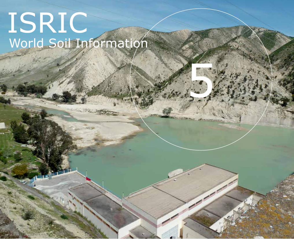
5ISRICWorld Soil Information
33
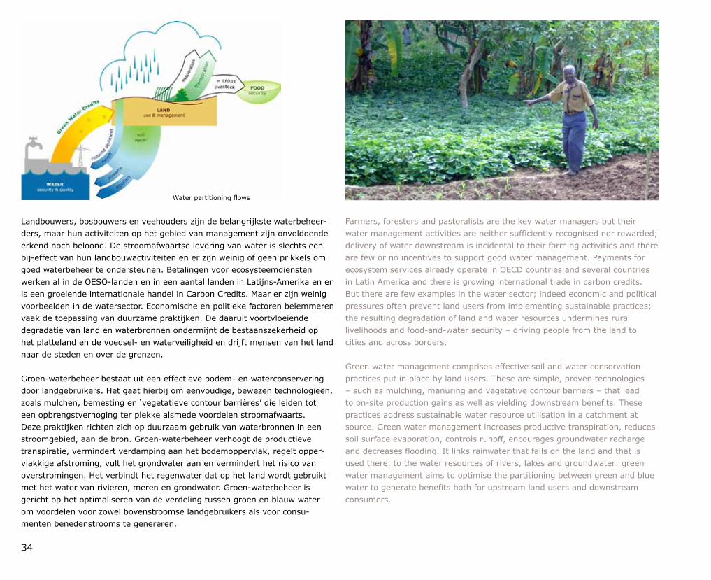
Een tekort aan zoet water brengt de algemene ontwikkeling en het levensonderhoud van bovenstroomse en benedenstroomse gemeenschappen in gevaar – evenals ecosystemen in vele delen van de wereld. De bron van alle zoet water is neerslag. Afhan kelijk van het beheer en gebruik van de bodem kan dit worden afgevoerd als oppervlakteafspoeling, verdamping of infiltratie in de bodem, waar het zowel kan worden gebruikt door planten (‘groen water’) of het grondwater en de bodemvoorraad aan water aanvult (‘blauw water’). Met een goed ‘groenwater management’ kan de hoeveelheid water die infiltreert in de bodem met een factor drie worden verhoogd, met vermindering van bodemerosie, droogte en overstromingen als gevolg. Dit is de meest effectieve en goedkoopste manier om aan de wereldwijde behoefte aan water en een verhoogde waterberging te voldoen, wat een voorwaarde is voor zowel een zekerder landbouw als voor voldoende economische ontwikkelingsmogelijkheden om uit de armoede te kunnen ontsnappen. Dit geldt vooral voor Afrika. Het is de enige manier voor de arme plattelandsbevolking om zich aan te passen aan klimaatverandering, die meer waterstress en minder betrouwbare regenval met zich mee zal brengen. Bovendien zal groenwatermanagement leiden tot verhoging van de opslag capaciteit voor koolstof in de bodem en daarmee bijdragen aan het tegengaan van klimaatverandering.
Shortage of fresh water jeopardizes the overall development and livelihoods of upstream and downstream communities – and ecosystems in many parts of the world. The source of all fresh water is precipitation. Depending on soil use and management, it may be shed as runoff, evaporate, or infiltrate into the soil where it either may be used by plants (green water) or recharge groundwater and stream base flow (blue water). With good green water management, the amount of water that infiltrates into the soil may be increased threefold – with corresponding reduction in soil erosion, drought, and floods. This is the most effective and least costly way to meet the global need for water and increased water storage, which is a prerequisite not only for more secure agriculture but all economic development to lead the way out of poverty. This is especially true for Africa; it is the only way open for poor rural people to adapt to climatic change that will bring increased water stress and lessreliable rainfall. Moreover, green water management will increase carbon storage in the soil and thereby contribute to climate change mitigation.
Green Water Credits: een investerings mechanisme om boeren in duurzaam landbeheer te ondersteunen
Green Water Credits: an investment mechanism to support farmers in sustainable land management
Contact Godert van Lynden
34
Landbouwers, bosbouwers en veehouders zijn de belangrijkste waterbeheerders, maar hun activiteiten op het gebied van management zijn onvoldoende erkend noch beloond. De stroomafwaartse levering van water is slechts een bijeffect van hun landbouwactiviteiten en er zijn weinig of geen prikkels om goed waterbeheer te ondersteunen. Betalingen voor ecosysteemdiensten werken al in de OESOlanden en in een aantal landen in LatijnsAmerika en er is een groeiende internationale handel in Carbon Credits. Maar er zijn weinig voorbeelden in de watersector. Economische en politieke factoren belemmeren vaak de toepassing van duurzame praktijken. De daaruit voortvloeiende degradatie van land en waterbronnen ondermijnt de bestaanszekerheid op het platteland en de voedsel en waterveiligheid en drijft mensen van het land naar de steden en over de grenzen.
Groenwaterbeheer bestaat uit een effectieve bodem en waterconservering door landgebruikers. Het gaat hierbij om eenvoudige, bewezen technologieën, zoals mulchen, bemesting en ‘vegetatieve contour barrières’ die leiden tot een opbrengstverhoging ter plekke alsmede voordelen stroomafwaarts. Deze praktijken richten zich op duurzaam gebruik van waterbronnen in een stroomgebied, aan de bron. Groenwaterbeheer verhoogt de productieve transpiratie, vermindert verdamping aan het bodemoppervlak, regelt oppervlakkige afstroming, vult het grondwater aan en vermindert het risico van overstromingen. Het verbindt het regenwater dat op het land wordt gebruikt met het water van rivieren, meren en grondwater. Groenwaterbeheer is gericht op het opti maliseren van de verdeling tussen groen en blauw water om voordelen voor zowel bovenstroomse landgebruikers als voor consumenten benedenstrooms te genereren.
Farmers, foresters and pastoralists are the key water managers but their water management activities are neither sufficiently recognised nor rewarded; delivery of water downstream is incidental to their farming activities and there are few or no incentives to support good water management. Payments for ecosystem services already operate in OECD countries and several countries in Latin America and there is growing international trade in carbon credits. But there are few examples in the water sector; indeed economic and political pressures often prevent land users from implementing sustainable practices; the resulting degradation of land and water resources undermines rural livelihoods and foodandwater security – driving people from the land to cities and across borders.
Green water management comprises effective soil and water conservation practices put in place by land users. These are simple, proven technologies – such as mulching, manuring and vegetative contour barriers – that lead to onsite production gains as well as yielding downstream benefits. These practices address sustainable water resource utilisation in a catchment at source. Green water management increases productive transpiration, reduces soil surface evaporation, controls runoff, encourages groundwater recharge and decreases flooding. It links rainwater that falls on the land and that is used there, to the water resources of rivers, lakes and groundwater: green water management aims to optimise the partitioning between green and blue water to generate benefits both for upstream land users and downstream consumers.
Water partitioning flows
35
SeptemberZoeken naar de derde weg
In september 2011 vond ‘De Groene Golflengte’ plaats, een debatweek op initiatief van Kees Slingerland om een einde te maken aan de aanhoudende polarisatie in het natuur debat. De overheid trekt zich steeds meer terug, maar wie neemt het stokje over? Provincies, bedrijven, organisaties, burgers? Natuur en sociale en economische ontwikkeling kunnen best samengaan, was een van de conclusies. Met natuurontwikkeling kunnen regio’s nieuwe economische groei creëren, en de kosten van lucht en waterzuivering beperken. In januari 2012 verscheen ‘Zoeken naar de derde weg’, een boekje waarin voortbordurend op de debatten wordt geconcludeerd dat een derde weg, met samenwerking tussen alle stakeholders, mogelijk is.
SeptemberIn search of the third way
The ‘Groene Golflengte’ (‘Green Wavelength’), a debate week set up by Kees Slingerland to end the persistent polarisation of the nature debate, took place in September 2011. Government is bowing out, but who will take its place? Provincial government, businesses, organisations, citizens? One of the conclusions was that it is possible to combine nature with social and economic development. Regions can create new economic growth, and limit the costs of air and water cleanup, by developing nature. In February 2012, ‘Zoeken naar de derde weg’ (‘In search of the third way) was published. The book picks up where the debates left off, concluding that a third way, marked by cooperation among all stakeholders, is possible.
Het Green Water Credits ‘Proofofconcept’ project in het Seboustroomgebied in Marokko (20092011) en de gedetailleerde ontwerpfase van het project in het Upper Tanastroomgebied in Kenia (20072011) hebben een sterke band tussen de bovenstroomse beheersactiviteiten en benedenstroomse waterbaten laten zien. Beide projecten toonden de haalbaarheid van het mechanisme van Green Water Credits aan en lieten tevens een sterke steun zien van land en watergebruikers, alsook van de overheid en de particuliere sector om dit mechanisme uit te voeren. Daarbij waren de gemeenschappelijke publieke en private belangen essentieel. In deze onlangs afgeronde projectfases zijn met hydrologische modellen de belangrijkste bronnen van water voor de grote benedenstroomse gebruikers en ook de brongebieden voor het dichtslibben van rivieren en stuwmeren geïdentificeerd, en zijn instrumenten en indicatoren ontwikkeld voor het op waarde schatten en monitoren van de voordelen. Studies door ISRIC en partners in het project hebben aangetoond dat een beter beheer van bodem en water de erosie vermindert, het grondwater aanvult en de rivierstromen beter reguleert. Volgens de studies zullen de voordelen van een beter beheer van bodem en water beduidend hoger uit vallen dan de kosten. Naast de voordelen benedenstrooms voor (hydro)elektriciteitsopwekking en drinkwater en een verminderd risico van overstromingen, zullen boeren bovenstrooms ook direct profiteren van een hogere productie.
The Green Water Credits ProofOfConcept project in the Sebou basin in Morocco (20092011) and the detailed Design project phase in the Tana Basin in Kenya (20072011) have shown strong links between upstream management activities and downstream water benefits. They also demonstrated both the feasibility of the Green Water Credits mechanism and revealed strong support from land and water users, government and the private sector to implement this mechanism – in which joint public and private ownership is essential. In these recently terminated project phases, key sources of water for the major downstream users and also the areas that are the sources of the siltation of rivers and reservoirs areas have been identified through the use of hydrological models; and tools and indicators have been developed for valuing and monitoring the benefits. Studies by ISRIC and its project partners have shown that improved soil and water management reduces erosion, increases ground water recharge and regulates river base flows. According to the studies, the benefits of better soil and water management far outstrip the costs. Beside downstream benefits for hydropower facilities and urban water provision benefits there will be increased production for upstream farmers. Other benefits are increase carbon sequestration and reduced flood damage.
36
OktoberVoedselzekerheid voor Ethiopië
Bodemvruchtbaarheid is terug op de internationale ontwikkelingsagenda door o.a. de toenemende behoefte aan voedsel en de stijgende kunstmestprijzen. Het CASCAPEproject onder coördinatie van Christy van Beek voor een betere voedselvoorziening in Ethiopië werd, nog geen zes maanden na de start, in oktober 2011 uitgebreid tot een project van maar liefst 10 miljoen euro. Het project zoekt naar ‘best practices’. Daarbij gaat het zowel om technische als om persoonlijke, sociaalculturele of economische zaken, alsmede om gender, voeding en waterbeheer. Wat maakt een ‘best practice’ tot een ‘best practice’? Als je dat weet, weet je ook wat de voorwaarden voor opschaling zijn.
OctoberFood security for Ethiopia
Soil fertility is back on the international development agenda, partly due to increasing needs for food and rising chemical fertiliser prices. The CASCAPE project for improved food supply in Ethiopia, coordinated by Christy van Beek, was extended in October 2011, less than six months after it began, becoming a tenmillioneuro project. The project looks to find best practices: technical or personal, sociocultural or economic, with regard to gender, nutrition and water management. What constitutes a best practice? If you know that, you know the conditions required for upscaling.
De meest effectieve mechanismen moeten worden vastgesteld op basis van locatiespecifieke agrohydrologische en sociaalinstitutionele omstandigheden en lokaal afgestemde conser veringsmaatregelen. Voor dit doel vormt de database van WOCAT, het World Overview of Conservation Approaches and Technologies programma, bestaande uit honderden case studies van duurzaam landgebruik over de hele wereld, een goede basis om de juiste maatregelen te selecteren voor de omstandigheden in de verschillende locaties.
Tijdens de afsluitende workshops gehouden in Kenia en Marokko in 2010 en 2011 zijn relevante financiële mechanismen en institutionele structuren besproken. Contante betaling aan de landbouwers werd in beide landen als mogelijke optie verworpen. Voor het Tana River Basin in Kenia werden fondsen geïdentificeerd om 400.000 kleine boeren te helpen met beter bodem en waterbeheer. Bijdragen van diverse bilaterale en multilaterale donoren (zoals het Internationale Fonds voor Agrarische Ontwikkeling, IFAD) en van private watergebruikers, worden beheerd door het Keniaanse Water Services Trust Fund en de Equity Bank, voor de uitvoering van een beter groenwaterbeheer. Individuele boeren kunnen zo leningen afsluiten ter verbetering van hun productie; gemeenschappen kunnen subsidie krijgen voor bodem en waterconservering, zoals mulchen en het maken van terrassen. De particuliere fondsen komen met name uit het Keniaanse hydroelektriciteitsbedrijf KenGen en het waterleidingbedrijf van Nairobi.
To determine the most effective mechanisms locationspecific agrohydrological and socioinstitutional conditions have to be taken into account as well as locally tuned Sustainable Land Management (SLM) practices. For this purpose, the database compiled by the World Overview of Conservation Approaches and Technologies (WOCAT) programme, comprising hundreds of SLM case studies all over the world, will form a sound basis from which to select appropriate SLM practices for the conditions in individual locations.
During concluding workshops held in Kenya and Morocco in 2010 and 2011 relevant financing mechanisms and institutional structures were discussed – cash payment to farmers was rejected in both countries as a possible option. For the Tana River Basin in Kenya funds were identified to help 400,000 smallholder farmers with soil and water management. USD 60 million from the International Fund for Agricultural Development (IFAD) and from private water users will be managed by the Water Services Trust Fund and the Equity Bank, one of Kenya’s largest banks for the implementation of Green Water Management measures. Individual farmers can take out a loan to improve their production; communities can obtain a grant for soil and water conservation practices such as mulching, conservation tillage, tied ridges and terraces. The private funds come from the Kenya Electricity Generating Company Limited (KenGen) and the Nairobi Water Company.

37
Het ISRIC is soortgelijke projecten op het gebied van Green Water Credits aan het voorbereiden voor de Maghreb in Marokko, Algerije en Tunesië en voor het Yangtsebekken in China. Het project in Kenia zal waarschijnlijk ook een vervolg krijgen: de Nederlandse instituten willen betrokken blijven bij de uitvoeringsfasen door trainingen en monitoring, met behulp van innovatieve methoden zoals remote sensing.
Meer informatie: www.greenwatercredits.net, www.wocat.net
ISRIC is preparing similar Green Water Credits projects for the Maghreb region (Morocco, Algeria, and Tunisia), and is also working on a proposal for China (Yangtze basin). And there will probably be a followup for the Kenya project: Dutch institutes aim to continue to train the Kenyan stakeholders and monitor the effects of the implementation phase, using innovative methods such as remote sensing and GIS.
More information: www.greenwatercredits.net, www.wocat.net
6GeoinformatieGeoinformation
39
In de Europese Landschapsconventie wordt landschap gedefinieerd als ‘een gebied, zoals waargenomen door mensen, waarvan het karakter het resultaat is van de actie en interactie van natuurlijke en/of menselijke factoren’. Deze definitie benadrukt de zintuiglijke relatie tussen de waarnemer en het landschap. Hoewel 'waargenomen door mensen' verwijst naar een holistische ervaring met alle zintuigen, wordt het vaak gereduceerd tot de visuele aspecten. Dit omdat naar schatting 80 procent van de zintuiglijke informatie over de ruimtelijke omgeving uit visuele waarneming komt. Ook het reikwijdte van onze zintuigen speelt hierbij een belangrijke rol. Daarbij kan onderscheid gemaakt worden tussen de 'Nahsicht' en 'Fernsicht'. De Nahsicht (nabijheid) is de omgeving die we kunnen waarnemen en ervaren met al onze zintuigen. De Fernsicht (vergezicht) is het deel van de omgeving die we vooral ervaren door het te zien. Het karakter van landschappen in landelijke en stedelijke gebieden wordt dus voor een belangrijk deel bepaald door visuele aspecten. Sterker nog, het is bepalend voor menselijk gedrag en de waardering van landschappen. Dit maakt het visuele landschap van cruciaal belang voor landschapsplanning, ontwerp en beheer, maar ook voor de monitoring en bescherming van landschappen. Maar hoe kunnen we 'gezicht van het landschap' en de waarneming, beleving en waardering ervan begrijpen? En hoe kunnen we deze inzichten toepassen in landschapsplanning, ontwerp en management?
The European Landscape Convention defines landscape as ‘an area, as perceived by people, which character is the result of the action and interaction of natural and/or human factors’. This definition clearly emphasises the sensory relationship between the observer and the landscape. Although ‘perceived by people’ refers to a holistic experience with all senses, very often it is reduced to the visual aspects. This is because an estimated 80 percent of our sensory input on the spatial environment comes from visual observation. The ‘range' of our senses also plays an important role in this. We can distinguish between the ‘Nahsicht’ and ‘Fernsicht’. The Nahsicht or proximity is the environment we can experience with all our senses; the Fernsicht we can call the landscape and is the part of our environment we mainly experience by vision. The character of rural and urban environments is, to a large extent, built upon visual perception. We can even go so far as to say that this determines human behaviour and appreciation of landscapes. The visual landscape is thus of crucial importance for landscape planning, design and management, as well as for monitoring and protecting landscapes. But how can we comprehend the ‘face of the landscape’ and our perception, experience and appreciation of it? And how can we make this applicable to landscape planning, design and management?
Visueel landschapsonderzoek
Visual landscape research
Contact Ron van Lammeren, Steffen Nijhuis
40
Deze vragen zijn niet nieuw. Nederland kent een lange traditie van visueel landschapsonderzoek (ook wel: landschapsbeeldkartering of fysiognomisch landschapsonderzoek) met een geschiedenis van ruim 50 jaar. Al in de jaren zestig van de vorige eeuw was er aandacht voor het visuele landschap hetgeen expliciet wordt gemaakt door legendaeenheden die verschillende maten van openheid weergeven op de kaart ‘Het landschap van Nederland en aangrenzende gebieden’ uit de Tweede nota ruimtelijke ordening (zie figuur). Deze overheidsbelangstelling en de toenemende wetenschappelijke aandacht voor de menselijke waarneming van de buitenruimte, met name in de Verenigde Staten, inspireert diverse onderzoekers in Wageningen en Delft. Deze startten verschillende onderzoekprojecten naar de visuele waarneming van het landschap. De verschillende invalshoeken en de rijke variatie in onderzoekthematiek en metho diek heeft tot twee onderzoekstromen geleid: het ‘Wageningse onderzoek’ dat zich vooral richt op het rurale gebied en het ‘Delftse onderzoek’ dat zich vooral richt op urbane gebieden en architectuur. Deze onderzoektradities worden bij elkaar gebracht en voortgezet in het boek ‘Exploring the Visual Landscape. Advances in Physiognomic Landscape Research in the Netherlands’, een resultaat van de samenwerking tussen de universiteiten van Delft en Wageningen.
These questions are not new. The Netherlands has a long tradition of research on the visual landscape (also referred to as landscape physiognomy and physiognomic landscape research) stretching back over half a century. In the 1960s visual landscape was already a focus, as can be seen in a map entitled ‘The landscape of the Netherlands and bordering regions’ which was published in the Second National Memorandum on Spatial Planning (see figure). The map presented the Dutch rural landscape as different ‘complexes of open spaces’. Government interest and the increasing academic interest in human perception of outside space, in particular in the United States, has inspired a number of researchers in Wageningen and Delft, who have set up various projects to study visual perception of the landscape. The different approaches and wide variety of research themes and methods have resulted in two research traditions: ‘Wageningen research' which focuses mainly on rural areas and ‘Delft research’ which focuses primarily on urban areas and architecture. These research traditions are brought together and taken a step further in the book ‘Exploring the Visual Landscape. Advances in Physiognomic Landscape Research in the Netherlands', which has been jointly produced by the universities of Delft and Wageningen.
NovemberMeer regen door Nederlandse berg
Ingenieursbureaus, architecten en projectontwikkelaars willen het idee van een twee kilometer hoge berg in Flevoland graag uitvoeren. Ook wielrenners en wintersporters zijn enthousiast. Ronald Hutjes, Herbert ter Maat en Eddy Moors onderzochten de gevolgen van zo’n berg voor het klimaat. Zij deden simulaties van de natte maand augustus 2006, met en zonder een 1500 meter hoge berg in Flevoland. In november 2011 concludeerden zij dat het in Flevoland twee tot drie maal zoveel zou gaan regenen. Flevoland zou gaan lijken op het Noorse Bergen, met een berg om te skiën, maar ook met een jaarlijks Regenfestival en parapluautomaten in de straten.
NovemberMountain in the Netherlands to bring more rain
Engineering firms, architects and developers would like to implement the idea of a 2000metrehigh mountain in the province of Flevoland. Other supporters of the idea include cycling and winter sports enthusiasts. Ronald Hutjes, Herbert ter Maat en Eddy Moors investigated the effects that such a mountain would have on the climate. They ran simulations of the wet month of August 2006, both with and without a 1500metre peak in Flevoland. In November 2011 they concluded that it would rain two or three times as much in that province, causing it to resemble Bergen in Norway, with a mountain to ski on – but with an annual rain festival too, and umbrella dispensers on the streets.
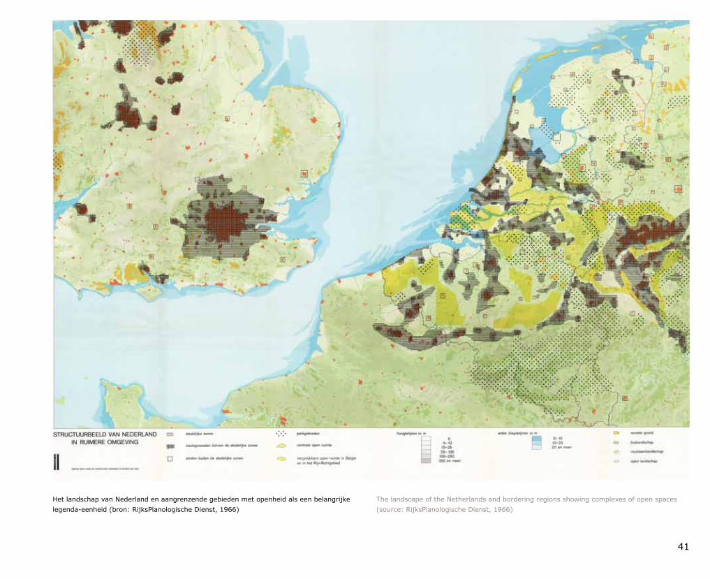
41
Het landschap van Nederland en aangrenzende gebieden met openheid als een belangrijke legendaeenheid (bron: RijksPlanologische Dienst, 1966)
The landscape of the Netherlands and bordering regions showing complexes of open spaces (source: RijksPlanologische Dienst, 1966)
42
Exploring the Visual Landscape beschrijft de lange traditie van visueel landschaps onderzoek die we in Nederland hebben en plaatst deze in een internationale context. Het geeft ook een overzicht van actuele ontwikkelingen in het onderzoekveld en laat beleidstoepassingen zien door een rijk palet aan bijdragen van diverse onderzoekers te presenteren. Visueel landschapsonderzoek wordt daarbij gezien als een inter disciplinaire aanpak waarbij de concepten van (a) landschapsplanning, ontwerp en management, (b) waarnemingsonderzoek en (c) methoden en technieken die op Geografische Informatie Science (GISc) zijn gebaseerd, worden gecombineerd waardoor ze elkaar versterken. De achterliggende gedachte is, dat door integratie van kennis van landschapswaarneming, de technische mogelijkheden van de geoinformatiekunde en methodologie van landschaps architectuur en stedenbouw, een solide basis ontstaat voor het in kaart brengen en beoordelen van het visuele landschap in steden, parken en landelijke gebieden. De huidige stand van het onderzoek toont bijvoorbeeld de grote potentie voor de verwerving van ontwerpkennis door verkenning van landschapsarchitectonische composities van ‘binnenuit’, maar biedt ook mogelijkheden om beschrijving van het landschapskarakter te verrijken met visuele landschapsindicatoren.
Exploring the Visual Landscape describes the long Dutch tradition of visual landscape research, and places it within an international context. The book showcases the latest developments in this research field, and contributions from a broad range of researchers provide a good overview of policy applications. Visual landscape research is regarded as an interdisciplinary approach in which the concepts of (a) landscape planning, design and management, (b) perception research and (c) Geographic Information Science (GISc) methods and techniques are combined and thus mutually reinforce each other. The idea behind this is that by integrating landscape perception data with the technical possibilities that geoinformation science provides and landscape architecture and urban planning methodology, a solid foundation is created upon which the visual landscape in cities, parks and rural areas can be mapped and evaluated. Current research demonstrates great potential for the acquisition of design understanding by examining landscape architectural compositions from ‘inside out’, but it also offers opportunities for enriching landscape character descriptions with visual landscape indicators.
DecemberKlimaat voor Ruimte afgesloten
Het onderzoekprogramma ‘Klimaat voor Ruimte’ bestudeerde in de periode 20062011 de gevolgen van klimaatverandering en manieren om daarmee om te gaan, gericht op het ruimtegebruik. In december 2011 hield het programma haar slotconferentie, waar de resultaten van het programma werden gepresenteerd, onder andere via ‘Ruimte voor Klimaat, praktijkboek voor klimaatbestendig inrichten’ (te downloaden via www.ruimtevoorklimaat.nl). Een boek vol voor beelden van projecten in Nederland waar adaptatie in de praktijk wordt gebracht. Al tijdens het onderzoek is geprobeerd een vertaalslag te maken naar de praktijk. Dat kon, omdat een groot deel van het onderzoek samen met de praktijk in ‘hotspots’ is uitgevoerd.
December
‘Climate changes Spatial Planning’ comes to a close
From 2006 to 2011, the research programme ‘Klimaat voor Ruimte’ (‘Climate changes Spatial Planning’) studied the effects on space utilisation of both climate change and approaches for dealing with it. The final conference took place in December 2011. Presentation of the results included a book containing many examples of projects in the Netherlands in which adaptation is put into practice: ‘Ruimte voor Klimaat, praktijkboek voor klimaatbestendig inrichten’ (‘Space for Climate, A handbook for climateproof spatial planning’; downloadable from www.ruimtevoorklimaat.nl). Practical applications were sought even during the research phase, as a great deal of the research was conducted in ‘hotspots’ together with those involved in realworld practice.
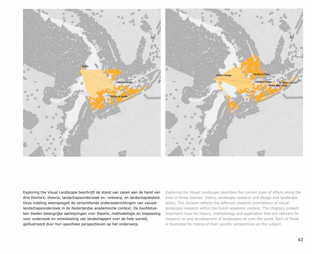
43
Exploring the Visual Landscape beschrijft de stand van zaken aan de hand van drie thema’s: theorie, landschapsonderzoek en ontwerp, en landschapsbeleid. Deze indeling weerspiegelt de verschillende onderzoekrichtingen van visueel landschaps onderzoek in de Nederlandse academische context. De hoofdstukken bieden belangrijke aanwijzingen voor theorie, metho dologie en toepassing voor onderzoek en ontwikkeling van landschappen over de hele wereld, geïllustreerd door hun speci fieke perspectieven op het onderwerp.
Exploring the Visual Landscape describes the current state of affairs along the lines of three themes: theory, landscape research and design and landscape policy. This division reflects the different research orientations of visual landscape research within the Dutch academic context. The chapters present important clues for theory, methodology and application that are relevant for research on and development of landscapes all over the world. Each of these is illustrated by means of their specific perspectives on the subject.
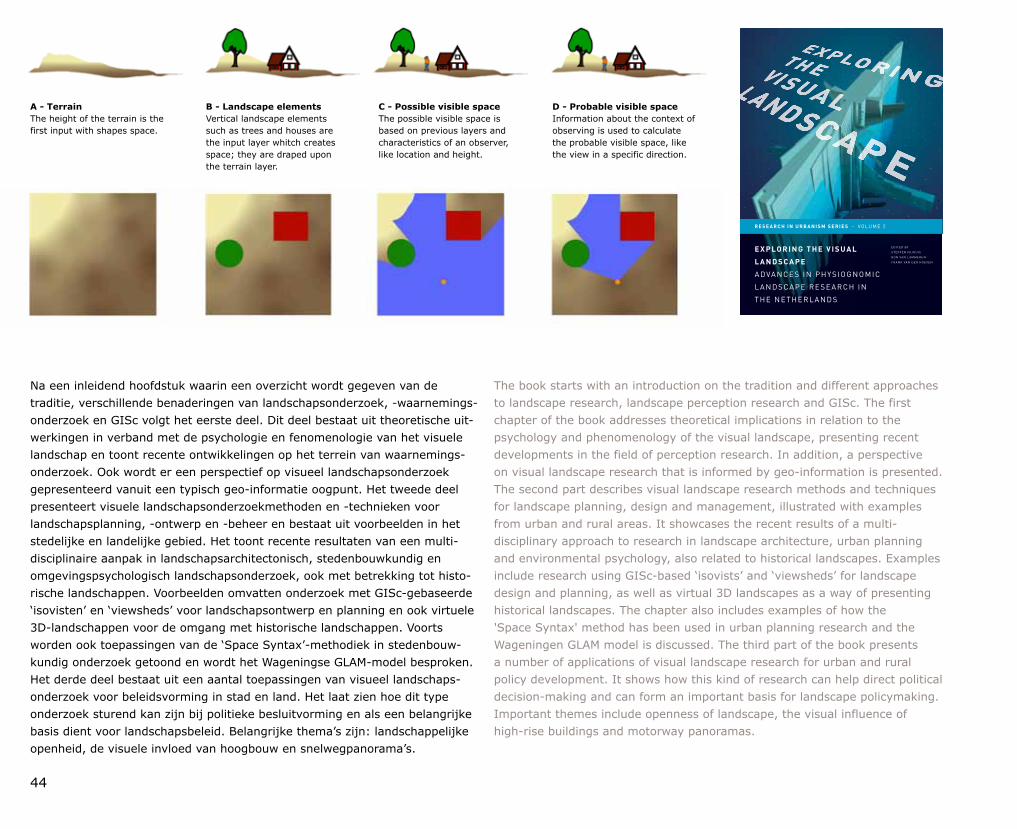
44
Na een inleidend hoofdstuk waarin een overzicht wordt gegeven van de traditie, verschillende benaderingen van landschapsonderzoek, waarnemingsonderzoek en GISc volgt het eerste deel. Dit deel bestaat uit theoretische uitwerkingen in verband met de psychologie en fenomenologie van het visuele landschap en toont recente ontwikkelingen op het terrein van waarnemingsonderzoek. Ook wordt er een perspectief op visueel landschapsonderzoek gepresenteerd vanuit een typisch geoinformatie oogpunt. Het tweede deel presenteert visuele landschapsonderzoekmethoden en technieken voor landschapsplanning, ontwerp en beheer en bestaat uit voorbeelden in het stedelijke en landelijke gebied. Het toont recente resultaten van een multidisciplinaire aanpak in landschapsarchitectonisch, stedenbouwkundig en omgevingspsychologisch landschapsonderzoek, ook met betrekking tot historische landschappen. Voorbeelden omvatten onderzoek met GIScgebaseerde ‘isovisten’ en ‘viewsheds’ voor landschapsontwerp en planning en ook virtuele 3Dlandschappen voor de omgang met historische landschappen. Voorts worden ook toepassingen van de ‘Space Syntax’methodiek in stedenbouwkundig onderzoek getoond en wordt het Wageningse GLAMmodel besproken. Het derde deel bestaat uit een aantal toepassingen van visueel landschapsonderzoek voor beleidsvorming in stad en land. Het laat zien hoe dit type onderzoek sturend kan zijn bij politieke besluitvorming en als een belangrijke basis dient voor landschapsbeleid. Belangrijke thema’s zijn: landschappelijke openheid, de visuele invloed van hoogbouw en snelwegpanorama’s.
The book starts with an introduction on the tradition and different approaches to landscape research, landscape perception research and GISc. The first chapter of the book addresses theoretical implications in relation to the psychology and phenomenology of the visual landscape, presenting recent developments in the field of perception research. In addition, a perspective on visual landscape research that is informed by geoinformation is presented. The second part describes visual landscape research methods and techniques for landscape planning, design and management, illustrated with examples from urban and rural areas. It showcases the recent results of a multidisciplinary approach to research in landscape architecture, urban planning and environmental psychology, also related to historical landscapes. Examples include research using GIScbased ‘isovists’ and ‘viewsheds’ for landscape design and planning, as well as virtual 3D landscapes as a way of presenting historical landscapes. The chapter also includes examples of how the 'Space Syntax' method has been used in urban planning research and the Wageningen GLAM model is discussed. The third part of the book presents a number of applications of visual landscape research for urban and rural policy development. It shows how this kind of research can help direct political decisionmaking and can form an important basis for landscape policymaking. Important themes include openness of landscape, the visual influence of highrise buildings and motorway panoramas.
E X P LO R I N G T H E V I S U A L
L A N D S C A P E
A DVA N C E S I N P H Y S I O G N O M I C
L A N D S CA P E R E S E A R C H I N
T H E N E T H E R L A N D S
E D I T E D B Y
S T E F F E N N I J H U I S
R O N VA N L A M M E R E N
F R A N K VA N D E R H O E V E N
R E S E A R C H I N U R B A N I S M S E R I E S . VO LU M E 2
A - TerrainThe height of the terrain is the first input with shapes space.
B - Landscape elementsVertical landscape elements such as trees and houses are the input layer whitch creates space; they are draped upon the terrain layer.
C - Possible visible spaceThe possible visible space is based on previous layers and characteristics of an observer, like location and height.
D - Probable visible spaceInformation about the context of observing is used to calculate the probable visible space, like the view in a specific direction.
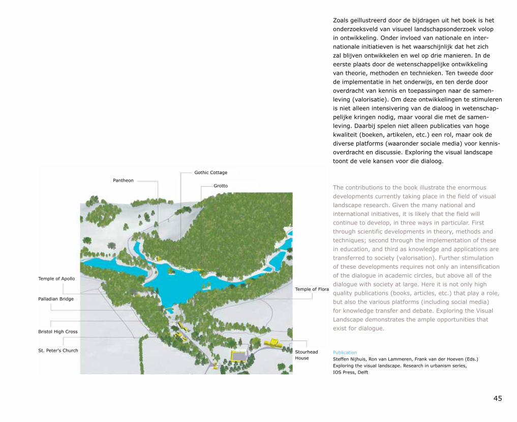
45
The contributions to the book illustrate the enormous developments currently taking place in the field of visual landscape research. Given the many national and international initiatives, it is likely that the field will continue to develop, in three ways in particular. First through scientific developments in theory, methods and techniques; second through the implementation of these in education, and third as knowledge and applications are transferred to society (valorisation). Further stimulation of these developments requires not only an intensification of the dialogue in academic circles, but above all of the dialogue with society at large. Here it is not only high quality publications (books, articles, etc.) that play a role, but also the various platforms (including social media) for knowledge transfer and debate. Exploring the Visual Landscape demonstrates the ample opportunities that exist for dialogue.
Publication Steffen Nijhuis, Ron van Lammeren, Frank van der Hoeven (Eds.) Exploring the visual landscape. Research in urbanism series, IOS Press, Delft
Zoals geïllustreerd door de bijdragen uit het boek is het onderzoeksveld van visueel landschapsonderzoek volop in ontwikkeling. Onder invloed van nationale en internationale initiatieven is het waarschijnlijk dat het zich zal blijven ontwikkelen en wel op drie manieren. In de eerste plaats door de wetenschappelijke ontwikkeling van theorie, methoden en technieken. Ten tweede door de implementatie in het onderwijs, en ten derde door overdracht van kennis en toepassingen naar de samenleving (valorisatie). Om deze ontwikkelingen te stimuleren is niet alleen intensivering van de dialoog in wetenschappelijke kringen nodig, maar vooral die met de samenleving. Daarbij spelen niet alleen publicaties van hoge kwaliteit (boeken, artikelen, etc.) een rol, maar ook de diverse platforms (waaronder sociale media) voor kennisoverdracht en discussie. Exploring the visual landscape toont de vele kansen voor die dialoog.
Pantheon
Gothic Cottage
Grotto
Temple of Flora
Stourhead House
St. Peter's Church
Bristol High Cross
Palladian Bridge
Temple of Apollo
46
De Environmental Sciences Group (ESG) neemt haar maatschappelijke verantwoordelijkheid door een beleid dat gericht is op een balans tussen economische, ecologische en maatschappelijke belangen. De ESG draagt zo bij aan een kwalitatief hoogwaardige en duurzame groene leefomgeving door het doen van fundamenteel en toegepast onderzoek en het geven van academisch onderwijs. De kwaliteit van ons werk staat voorop, waarbij de belangen van mens en milieu in hun onderlinge samenhang worden beschouwd. Medewerkers, studenten, klanten en andere belanghebbenden kunnen erop rekenen dat bij beleidskeuzes aspecten zoals veiligheid, gezondheid, welzijn en milieu worden meegenomen. Communicatie, openheid en het nakomen van afspraken zijn kernbegrippen in de gekozen aanpak.
Organisatiebreed wordt gewerkt aan kwaliteitsverbetering. Het doel is de visitaties als toets van wetenschappelijke kwaliteit succesvol af te ronden. Speerpunten zijn het streven naar tevreden klanten en kwaliteit van onderzoek. Alterra werkt met een kwaliteitsmanagementsysteem volgens de norm ISO 9001:2008. De zorg voor de groene ruimte staat centraal binnen de eigen organisatie. Gestreefd wordt naar continue verbetering van de milieuprestaties. Een actief milieubeleid vormt een integraal onderdeel van de ESG bedrijfsvoering en strategie. De ESG voldoet aan alle van toepassing zijnde milieuwet en regelgeving, evenals het milieubeleid van Wageningen UR en relevante convenanten. De ESG wil een goede en veilige werk omgeving bieden en schade aan de gezondheid van medewerkers en andere betrokkenen voorkomen. Het beleid is erop gericht het personeel te vrijwaren van druk die hun functioneren nadelig kan beïnvloeden.
Door invulling te geven aan de internationale richtlijn NENENISO 26000 wil de ESG op een goede en aantoonbare manier omgaan met haar maatschappelijke verant woordelijkheid (MVO). De principes en thema’s beschreven in deze richtlijn zijn belangrijke uitgangspunten voor de besluitvorming binnen de ESG. Door middel van een zelfverklaring (waarbij de methodiek van de NPR 9026:2011 wordt toegepast) wil de ESG periodiek beoordelen of de MVOprincipes en richtlijnen worden toegepast. Speerpunten voor de komende periode zijn: actieve betrokkenheid van stakeholders, maatschappelijke rol van ESG richting de politiek en MVOaspecten bij de voorbereiding van internationale projectvoorstellen.
The Environmental Sciences Group (ESG) exercises its social responsibility through policy aimed at balancing economic, ecological and social interests. In this way, the ESG contributes to a highquality, sustainable, green environment for conducting basic and applied research and providing academic education. Our first priority is the quality of our work, in which we view the interests of people and those of the environment as being interdependent. Staff, students, clients and other stakeholders can rest assured that aspects such as safety, health, wellbeing and the environment are taken into account in decisions about policy. Our approach reflects the core concepts of communication, openness and integrity.
Quality improvements are in progress across the entire organisation. The goal is successful completion of the inspection process, as a test of scientific quality. A major objective is to strive for client satisfaction and research quality. Alterra adheres to a quality management system in accordance with the ISO 9001:2008 standard. Caring for green space is central to our organisation. We strive for continual improvement in environmental performance, and active environmental policy forms an integral part of ESG management and strategy. The ESG meets the standards of all applicable environmental laws and regulations, and of Wageningen UR environmental policy and relevant agreements. The ESG aims to offer a positive, safe work environment and to prevent damage to the health of personnel and other concerned parties. Policy is in place to protect employees from pressure that could exert a negative influence on their ability to do their jobs.
By adhering to the international guideline NENENISO 26000, the ESG aims to assume its social responsibility (CSR) in a positive, demonstrable manner. The principles and themes described in this guideline are an important basis for decisionmaking within the ESG. The organisation intends to evaluate its adherence to CSR principles and guidelines by means of a statement of selfdeclaration (applying the method in NPR 9026:2011). Spearheads for the foreseeable future are: active involvement of stakeholders; the societal role of the ESG in policy, and CSR aspects in the preparation of international project proposals.
Duurzaamheidsverklaring Environmental Sciences Group Environmental Sciences Group Sustainability Declaration
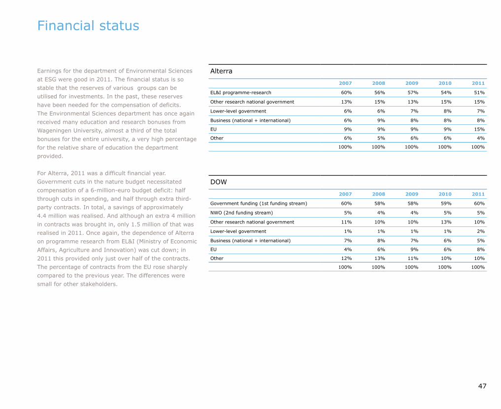
Alterra
2007 2008 2009 2010 2011
EL&I programmeresearch 60% 56% 57% 54% 51%
Other research national government 13% 15% 13% 15% 15%
Lowerlevel government 6% 6% 7% 8% 7%
Business (national + international) 6% 9% 8% 8% 8%
EU 9% 9% 9% 9% 15%
Other 6% 5% 6% 6% 4%
100% 100% 100% 100% 100%
DOW
2007 2008 2009 2010 2011
Government funding (1st funding stream) 60% 58% 58% 59% 60%
NWO (2nd funding stream) 5% 4% 4% 5% 5%
Other research national government 11% 10% 10% 13% 10%
Lowerlevel government 1% 1% 1% 1% 2%
Business (national + international) 7% 8% 7% 6% 5%
EU 4% 6% 9% 6% 8%
Other 12% 13% 11% 10% 10%
100% 100% 100% 100% 100%
47
Financial status
Earnings for the department of Environmental Sciences at ESG were good in 2011. The financial status is so stable that the reserves of various groups can be utilised for investments. In the past, these reserves have been needed for the compensation of deficits. The Environmental Sciences department has once again received many education and research bonuses from Wageningen University, almost a third of the total bonuses for the entire university, a very high percentage for the relative share of education the department provided.
For Alterra, 2011 was a difficult financial year. Government cuts in the nature budget necessitated compensation of a 6millioneuro budget deficit: half through cuts in spending, and half through extra thirdparty contracts. In total, a savings of approximately 4.4 million was realised. And although an extra 4 million in contracts was brought in, only 1.5 million of that was realised in 2011. Once again, the dependence of Alterra on programme research from EL&I (Ministry of Economic Affairs, Agriculture and Innovation) was cut down; in 2011 this provided only just over half of the contracts. The percentage of contracts from the EU rose sharply compared to the previous year. The differences were small for other stakeholders.
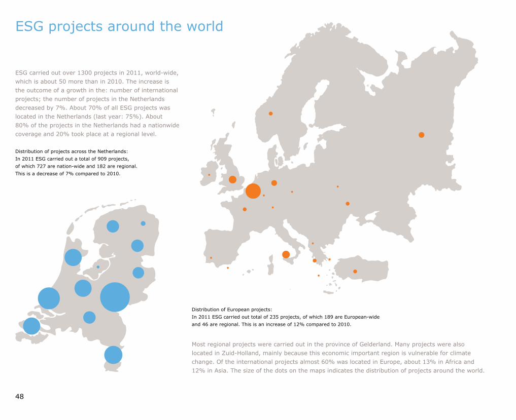
48
ESG carried out over 1300 projects in 2011, worldwide, which is about 50 more than in 2010. The increase is the outcome of a growth in the: number of international projects; the number of projects in the Netherlands decreased by 7%. About 70% of all ESG projects was located in the Netherlands (last year: 75%). About 80% of the projects in the Netherlands had a nationwide coverage and 20% took place at a regional level.
ESG projects around the world
Most regional projects were carried out in the province of Gelderland. Many projects were also located in ZuidHolland, mainly because this economic important region is vulnerable for climate change. Of the international projects almost 60% was located in Europe, about 13% in Africa and 12% in Asia. The size of the dots on the maps indicates the distribution of projects around the world.
Distribution of projects across the Netherlands:In 2011 ESG carried out a total of 909 projects, of which 727 are nationwide and 182 are regional. This is a decrease of 7% compared to 2010.
Distribution of European projects:In 2011 ESG carried out total of 235 projects, of which 189 are Europeanwide and 46 are regional. This is an increase of 12% compared to 2010.
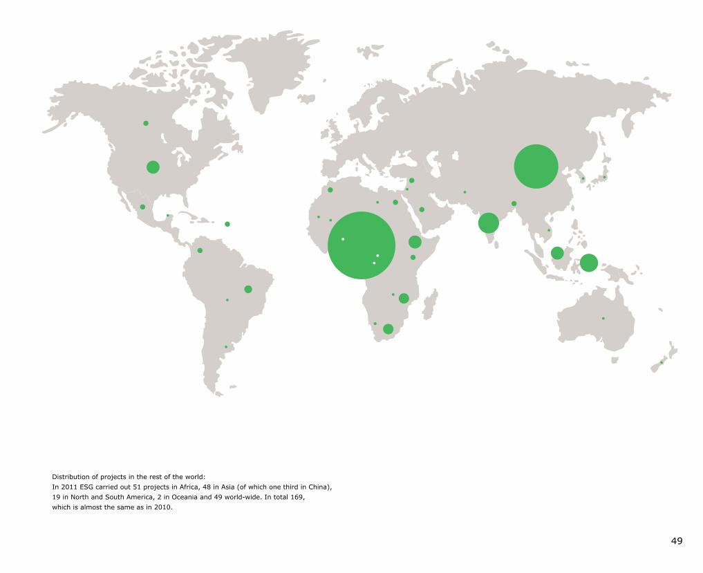
49
Distribution of projects in the rest of the world:In 2011 ESG carried out 51 projects in Africa, 48 in Asia (of which one third in China), 19 in North and South America, 2 in Oceania and 49 worldwide. In total 169, which is almost the same as in 2010.
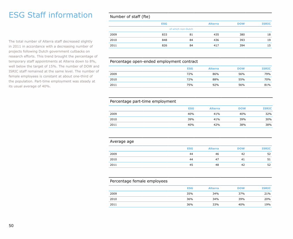
Number of staff (fte)
ESG Alterra DOW ISRIC
of which nonDutch
2009 833 81 435 380 18
2010 848 84 436 393 19
2011 826 84 417 394 15
Percentage openended employment contract
ESG Alterra DOW ISRIC
2009 72% 86% 56% 79%
2010 72% 88% 55% 70%
2011 75% 92% 56% 81%
Percentage parttime employment
ESG Alterra DOW ISRIC
2009 40% 41% 40% 32%
2010 39% 41% 39% 30%
2011 40% 42% 38% 38%
Percentage female employees
ESG Alterra DOW ISRIC
2009 35% 34% 37% 21%
2010 36% 34% 39% 20%
2011 36% 33% 40% 19%
Average age
ESG Alterra DOW ISRIC
2009 44 46 42 52
2010 44 47 41 51
2011 45 48 42 52
50
ESG Staff information
The total number of Alterra staff decreased slightly in 2011 in accordance with a decreasing number of projects following Dutch government cutbacks on research efforts. This trend brought the percentage of temporary staff appointments at Alterra down to 8%, well below the target of 15%. The number of DOW and ISRIC staff remained at the same level. The number of female employees is constant at about onethird of the population. Parttime employment was steady at its usual average of 40%.

Bachelor degree programme
2005 2006 2007 2008 2009 2010 2011
Forest and Nature Management 49 33 20 52 60 48 64
Soil, Water, Atmosphere 38 33 36 47 63 74 59
International Land and Water Management 19 26 42 46 55 34 48
Landscape Architecture and Spatial Planning 42 40 51 46 50 58 59
Environmental Sciences 9 13 13 25 26 24 16
Tourism (new programme in 2010) 27 50
Total 157 145 162 216 254 265 296
Master programme
2005 2006 2007 2008 2009 2010 2011
Climate Studies 5 6 4 5 17 11 13
Environmental Sciences 89 90 69 50 66 67 39
Forest and Nature Conservation 54 66 57 58 67 37 36
Geoinformation Science 29 23 12 20 15 18 15
Hydrology and Water Quality 24 19 17 17 28 10 *
International Land and Water Management 26 30 27 39 45 19 11
Leisure, Tourism and Environment 37 22 33 38 34 29 18
Landscape Architecture and Planning 43 40 33 36 52 27 14
Meteorology and Air Quality 8 10 10 12 12 2 *
Soil Science 7 11 8 9 12 3 *
Urban Environmental Management 30 18 19 10 29 27 29
Earth and Environment 15*
Total 352 335 289 294 377 250 190
* In 2011 the programmes Hydrology and Water Quality, Meteorology and Air Quality and Soil Science combined to form the new master programme Earth and Environment.
Wageningen University total: 1090Environmental Sciences: 296 (27%)
Wageningen University total: 699Environmental Sciences: 190 (27%)
51
Bachelor’s enrolments 2005 – 2011
First years MSc students 2005 – 2011: Master’s enrolments from outside Wageningen
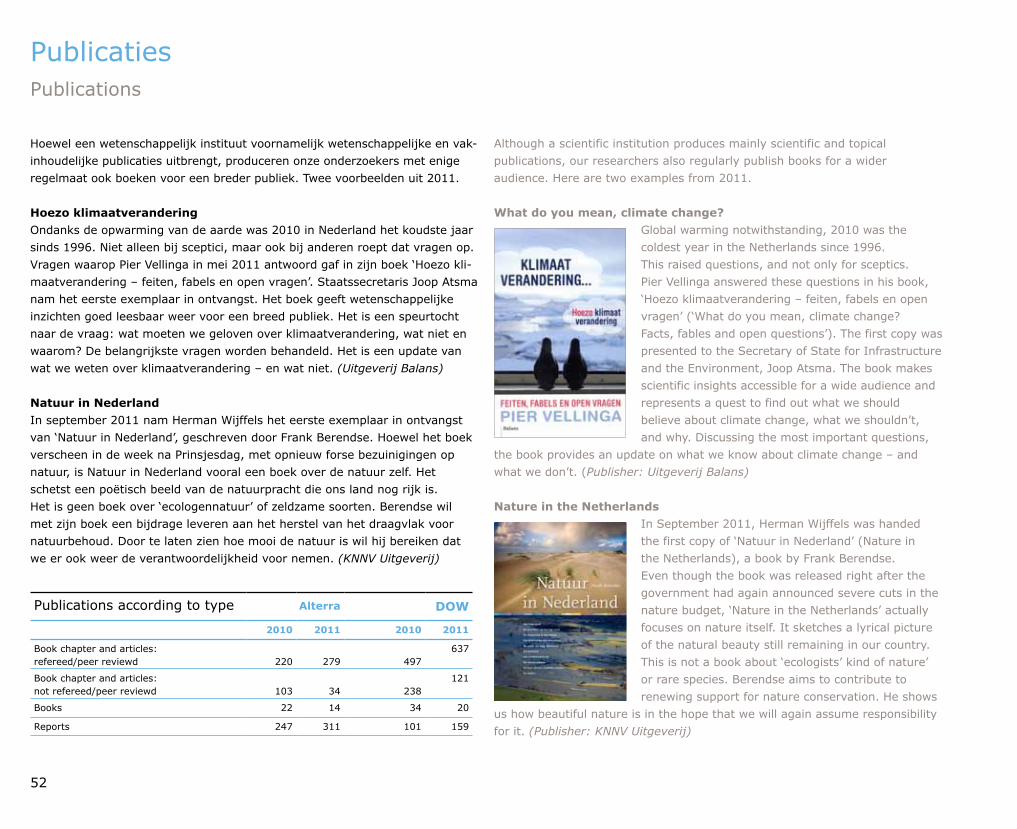
Publications according to type Alterra DOW
2010 2011 2010 2011
Book chapter and articles: refereed/peer reviewd 220 279 497
637
Book chapter and articles: not refereed/peer reviewd 103 34 238
121
Books 22 14 34 20
Reports 247 311 101 159
52
Hoewel een wetenschappelijk instituut voornamelijk wetenschappelijke en vakinhou delijke publicaties uitbrengt, produceren onze onderzoekers met enige regelmaat ook boeken voor een breder publiek. Twee voorbeelden uit 2011.
Hoezo klimaatveranderingOndanks de opwarming van de aarde was 2010 in Nederland het koudste jaar sinds 1996. Niet alleen bij sceptici, maar ook bij anderen roept dat vragen op. Vragen waarop Pier Vellinga in mei 2011 antwoord gaf in zijn boek ‘Hoezo klimaatverandering – feiten, fabels en open vragen’. Staatssecretaris Joop Atsma nam het eerste exemplaar in ontvangst. Het boek geeft wetenschappelijke inzichten goed leesbaar weer voor een breed publiek. Het is een speurtocht naar de vraag: wat moeten we geloven over klimaatverandering, wat niet en waarom? De belangrijkste vragen worden behandeld. Het is een update van wat we weten over klimaatverandering – en wat niet. (Uitgeverij Balans)
Natuur in NederlandIn september 2011 nam Herman Wijffels het eerste exemplaar in ontvangst van ‘Natuur in Nederland’, geschreven door Frank Berendse. Hoewel het boek verscheen in de week na Prinsjesdag, met opnieuw forse bezuinigingen op natuur, is Natuur in Nederland vooral een boek over de natuur zelf. Het schetst een poëtisch beeld van de natuurpracht die ons land nog rijk is. Het is geen boek over ‘ecologennatuur’ of zeldzame soorten. Berendse wil met zijn boek een bijdrage leveren aan het herstel van het draagvlak voor natuurbehoud. Door te laten zien hoe mooi de natuur is wil hij bereiken dat we er ook weer de verantwoordelijkheid voor nemen. (KNNV Uitgeverij)
Although a scientific institution produces mainly scientific and topical publications, our researchers also regularly publish books for a wider audience. Here are two examples from 2011.
What do you mean, climate change?Global warming notwithstanding, 2010 was the coldest year in the Netherlands since 1996. This raised questions, and not only for sceptics. Pier Vellinga answered these questions in his book, ‘Hoezo klimaatverandering – feiten, fabels en open vragen’ (‘What do you mean, climate change? Facts, fables and open questions’). The first copy was presented to the Secretary of State for Infrastructure and the Environment, Joop Atsma. The book makes scientific insights accessible for a wide audience and represents a quest to find out what we should believe about climate change, what we shouldn’t, and why. Discussing the most important questions,
the book provides an update on what we know about climate change – and what we don’t. (Publisher: Uitgeverij Balans)
Nature in the NetherlandsIn September 2011, Herman Wijffels was handed the first copy of ‘Natuur in Nederland’ (Nature in the Netherlands), a book by Frank Berendse. Even though the book was released right after the government had again announced severe cuts in the nature budget, ‘Nature in the Netherlands’ actually focuses on nature itself. It sketches a lyrical picture of the natural beauty still remaining in our country. This is not a book about ‘ecologists’ kind of nature’ or rare species. Berendse aims to contribute to renewing support for nature conservation. He shows
us how beautiful nature is in the hope that we will again assume responsibility for it. (Publisher: KNNV Uitgeverij)
Publicaties Publications
53
Raad van Advies ESG ESG Advisory Board
Chris Kalden directeur Staatsbosbeheer director Staatsbosbeheer (nature management organisation)
Harry Baayen algemeen directeur Deltares managing director Deltares (institute for applied research on water, subsurface and infrastructure)
Rob van Brouwershaven directeur Natuur, Landschap en Platteland, ministerie van Economische Zaken, Landbouw en Innovatie director for Nature, Landscape and Rural Affairs, ministry of Economic Affairs, Agriculture and Innovation
Yttje Feddes Feddes/Olthof Landschapsarchitecten Feddes/Olthof Landscape Architects
Roel Feringa directeur Water, DirectoraatGeneraal Water, ministerie van Infrastructuur en Milieu director of water, Directorate General Water, ministry of Infrastructure and the Environment
Hans Haerkens directeur Haerkens Resultancy director Haerkens Resultancy
Kees Plug directeur Duurzaam produceren, ministerie van Infrastructuur en Milieu (eind 2011 teruggetreden) director of Sustainable production, ministry of Infrastructure and the Environment (stepped down end of 2011)
Sylvo Thijsen adviseur op persoonlijke titel advisor in a personal capacity
Chris Zevenbergen directeur Business Development, Dura Vermeer; hoogleraar afdeling Waterbouwkunde TU Delft director Business Development, Dura Vermeer (building and infrastructure); professor at the Water Engineering Department, Technical University Delft Kees Slingerland algemeen directeur Environmental Sciences Group, Wageningen UR managing director, Environmental Sciences Group, Wageningen UR
Auke de Bruin directeur bedrijfsvoering Environmental Sciences Group, Wageningen UR director of operations, Environmental Sciences Group, Wageningen UR
Henk Wolfert directiesecretaris Environmental Sciences Group, Wageningen UR executive secretary, Environmental Sciences Group, Wageningen UR
54
55
Colofon Colophon
samenstelling en redactie | compilation and editing ESG
teksten en afbeeldingen | text and illustrations ESG
vormgeving | design Wageningen UR, Communication Services
vertaling | translation Sara van OtterlooButler, Diane Schaap
druk | print OBT BV, Den Haag
Dit is een uitgave van de Environmental Sciences Group (ESG) van Wageningen UR (University & Research centre).
De ESG is een samenwerkingsverband tussen het onderzoekinstituut Alterra en het departement Omgevingswetenschappen van Wageningen University.
This is a publication of the Environmental Sciences Group (ESG), Wageningen UR (University & Research centre).
ESG is a cooperation between the research institute Alterra and the department of Environmental Sciences of Wageningen University.

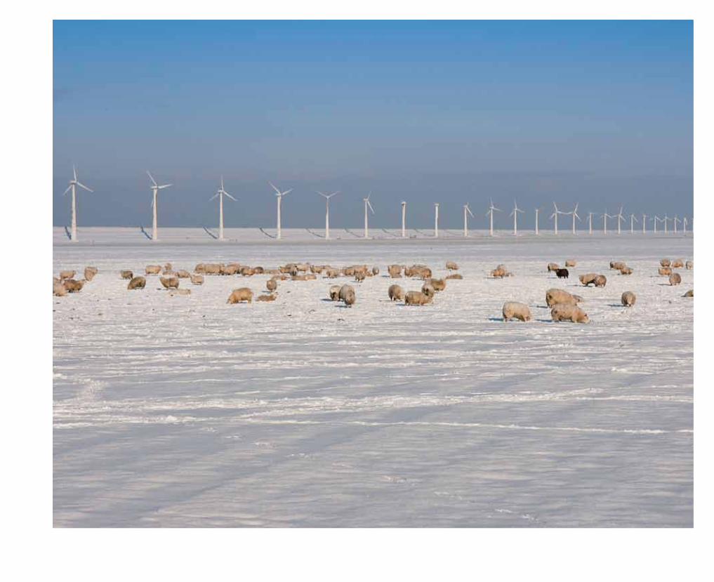
Environmental S
ciences 2011W
ageningen UR

![JOYFIT24ïË# ESSO N M 297 5 aft NEW NEW NEW …...2020/04/01 · JOYFIT24ïË# ESSO N M 297 5 aft NEW NEW NEW NAOMI OR 7Ëä NEW (ËÊI]) JOYFlTõ/uUku NEW LINE LINE Instagram @4430mfwb](https://static.fdocuments.nl/doc/165x107/5f4bbf2e9b9d421760522d2a/joyfit24-esso-n-m-297-5-aft-new-new-new-20200401-joyfit24-esso.jpg)